
Boston Mountains
| Boston Mountains ecoregion | |
|---|---|
Humid subtropical (Cwa ) |
The Boston Mountains is a
The Boston Mountains ecoregion has been subdivided into two Level IV ecoregions.[2][3]
Description
The ecoregion is mountainous, forested, and underlain by
Geology and physiography

The Boston Mountains are a
The area is underlain by Pennsylvanian sandstone, shale, and siltstone, where some folding and faulting has occurred.[5] The sandstone beds become thinner with higher shale content in the west as the mountains decline in elevation.[6]
The range covers an area of 5,770 square miles (14,900 km2)..
General description
The Boston Mountains form the southwestern part of the
Rivers and streams
The Boston Mountains are the source of rivers and streams that flow out from the mountains in all directions. Within a 3 miles (4,800 m) radius of a point just west of the summits discussed above are located the sources of the
In Arkansas, the Boston Mountains are found in the following counties: Boone, Carroll, Cleburne, Conway, Crawford, Franklin, Independence, Johnson, Madison, Newton, Pope, Searcy, Stone, Van Buren, and Washington.
In Oklahoma, the Boston Mountains are found in these counties: Adair, Cherokee, Muskogee, Sequoyah, and Wagoner.
Gallery
Landscapes
-
 Buffalo Wilderness
 -
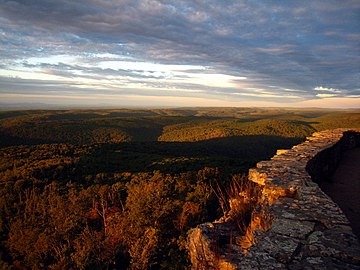
 View from Hawksbill Crag
 -
 Looking east on Gaither Mountain from AR 43. The plateau of the Boston Mountains is clearly visible on the right.
 -
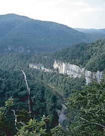 Buffalo River from river trail overlook near Steel Creek in the Boston Mountains
 -
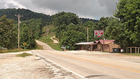 Low Gap community in the Boston Mountains
 -
 White Rock Mountain


See also
- Cookson Hills
- Sam's Throne
- Ecoregions defined by the EPA and the Commission for Environmental Cooperation:
- The conservation group World Wildlife Fundmaintains an alternate classification system:
References
- ^ Arkansas’ Boston Mountains
- ^ a b
 This article incorporates public domain material from Woods, AJ; Foti, TL; Chapman, SS; Omernik, JM; et al. Ecoregions of Arkansas (PDF). United States Geological Survey. (color poster with map, descriptive text, summary tables, and photographs).
- ^ This article incorporates public domain material from Woods, A.J., Omernik, J.M., Butler, D.R., Ford, J.G., Henley, J.E., Hoagland, B.W., Arndt, D.S., and Moran, B.C. Ecoregions of Oklahoma (PDF). United States Geological Survey. Retrieved January 18, 2018.
{{citation}}: CS1 maint: multiple names: authors list (link) (color poster with map, descriptive text, summary tables, and photographs). - ^ "Physiographic divisions of the conterminous U. S." U.S. Geological Survey. Retrieved 2007-12-06.
- ^ "Designing A Future For Arkansas Wildlife". State of Arkansas. Retrieved 2007-12-30.
- ISBN 9780405026591.
boston mountains physiography.
- ^ Gromadzki, Gregory and Richard Marston. "Boston Mountains". Encyclopedia of Oklahoma History and Culture. Accessed September 27, 2016.
- ^ a b Fallsville, Arkansas, 7.5 Minute Topographic Quadrangle, USGS, 1967
- ^ Boston, Arkansas, 7.5 Minute Topographic Quadrangle, USGS, 1973
- ^ [NAD83 geographic coordinates for TWK are N35.8631°, W093.4544°. Coordinates for the four unnamed highest peaks are N35.8607°, W093.4935°; N35.8151°, W093.4968°; N35.8126°, W093.4984°; and N35.7990°, W093.5005°]
External links
- Boston Mountain MLRA description.
- Encyclopedia of Oklahoma History and Culture -" Boston Mountains"
- U.S. Geological Survey Geographic Names Information System: Boston Mountains
Mountains of Arkansas | |
|---|---|
| Ouachita Mountains | |
| Ozarks | |
| Others | |
| Authority control databases: National |
|---|