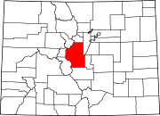
Buckskin Joe, Park County, Colorado
Buckskin Joe | |
|---|---|
 The Park County courthouse, originally built in Buckskin Joe, was later moved to Fairplay, and is now in the South Park City Museum in Fairplay. | |
| Coordinates: 39°17′35.16″N 106°5′17.16″W / 39.2931000°N 106.0881000°W | |
| Elevation | 3,280 m (10,760 ft) |
Buckskin Joe is an
History

The area was first inhabited by Non-Native Americans in 1859 during the
The town was formally organized in September 1860 and named Laurette, a contraction of the first names of the only two women in the camp, the sisters Laura and Jeanette Dodge.
Mining shifted to rich

The placer and vein gold deposits were rich, but were quickly exhausted. By 1866, the town was reported to be deserted, and the courthouse building was moved down the valley to the new county seat of Fairplay. In the late 1950s, Horace Tabor's general store was dismantled, hauled away, and reassembled at the tourist attraction and movie set also called Buckskin Joe, 70 miles (110 km) away from the original site. It remained there until 2011 when it, along with the entire tourist attraction and movie set, was sold to a private collector and moved to a private ranch in western Colorado.[6]
Geography
Buckskin Joe is located about 2 miles (3 km) west of Alma, Colorado at 39°17′35″N 106°05′17″W / 39.2931°N 106.0881°W at an elevation of 10,761 feet (3,280 m).[7]
Notable residents
- John Lewis Dyer, Methodist circuit rider missionary, also arrived in Buckskin Joe in 1861, having migrated from Minnesota.[8]
- Frank H. Mayer, former U.S. marshal in Buckskin Joe, former buffalo hunter[9]
- "Silverheels" (proper name unknown) was a popular dance hall girl at Buckskin Joe and the subject of many apocryphal stories. Mount Silverheels is named in her honor.[10]
- U.S. senator, arrived in Buckskin Joe in 1861 and ran a store with his first wife.
See also
- Bibliography of Colorado
- Geography of Colorado
- History of Colorado
- Index of Colorado-related articles
- List of Colorado-related lists
- Outline of Colorado
References
- ISBN 0-918654-42-4.
- ^ "From the silver mines," Daily Rocky Mountain News, 18 Sept. 1860, p. 2.
- ^ Muiriel Sibell Wolle, "From 'Sailors' Diggings' to 'Miners' Delight," Western Folklore, 1954, v.18, p.44.
- ^ Park County Local History Archives: Hiking through history Archived July 24, 2008, at the Wayback Machine Retrieved November 29, 2008.
- ^ Robert L. Brown (1968). Ghost Towns of the Colorado Rockies. Caxton Press. p. 69. Retrieved November 30, 2008.
ghost towns of the colorado rockies.
- ^ Wineke, Andrew (August 29, 2011). "Mystery buyer for Buckskin Joe revealed to be billionaire Koch brother". The Gazette. Colorado Springs, Colorado. Retrieved July 6, 2020.
- ^ "Geographic Names Information System". United States Geological Survey, United States Department of the Interior. Retrieved September 12, 2023.
- ^ "Biography of Famous Preacher Father Dyer Part 1". trivia-library.com. Retrieved January 19, 2014.
- ISBN 978-1-62619-161-7, pp. 53-58.
- ^ Robert L. Brown (1968). Ghost Towns of the Colorado Rockies. Caxton Press. pp. 71–73. Retrieved November 29, 2008.
ghost towns of the colorado rockies.


