
Crocker Mountains
(Redirected from
Crocker Range
)
| Crocker Mountains | |
|---|---|
 Crocker Mountains as seen from Ranau–Tamparuli Road. | |
| Highest point | |
| Peak | Mount Kinabalu |
| Elevation | 4,095 m (13,435 ft) |
| Coordinates | 5°45′N 116°30′E / 5.750°N 116.500°E |
| Naming | |
| Etymology | William Maunder Crocker[1] |
| Native name | Banjaran Crocker (Malay) |
| Geography | |
 Crocker Mountains Map showing location of Crocker Mountain range within Malaysia. | |
| Country | Malaysia |
| State | Sabah |
| Region | West Coast and Interior divisions |
| Districts | Keningau, Papar, Penampang, Ranau, Tambunan, Kota Belud, Kota Marudu, Tuaran and Kota Kinabalu |
Crocker Mountains (Malay: Banjaran Crocker) is a mountain range extending from the West Coast until Interior divisions of Sabah, Malaysia that separates the west and east coast of Sabah. At an average height of 1,800 metres (5,906 ft), it is the highest mountain range in the state. It is named after the British administrator in North Borneo, William Maunder Crocker.[2][3][4]
Geology
The mountain range is made up of uplifted and folded
water catchment to supply water to various rivers in the west coast and interior districts of Sabah including the Papar River, the Kimanis River, the Bongawan River, the Membakut River, the Padas River and the Melalap River that flow west to the park while the Pegalan River, the Pampang River, the Apin-Apin River, the Tendulu River, the Melalap River, the Liawan River and the Tikalod River flow in the opposite direction.[8]
History
The area surrounding
UNESCO Biosphere Reserve, becoming the second Malaysian site to be so designated, after Chini Lake in the state of Pahang on the peninsular side.[12][13][14]
Biodiversity
The Crocker Mountains Forest Reserve area has a wide range of floral and faunal diversity and has the highest diversity of nocturnal insects in all the 20 forest reserves surveyed within the Heart of Borneo area in Sabah; it has recorded a number of endemic species.[8][15][16]
Gallery
-
 Map of the mountain range.
 -
 The mountain range with a sea of clouds.
 -
 The mountain range as seen from Ranau District.
 -
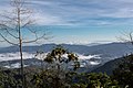 View of the mountain range from Ranau–Tamparuli Road.
 -
 The mountain range as seen from Ling San Pagoda in Tuaran District.


References
- ISBN 978-1-84162-252-1.
- ISBN 978-0-938522-17-1.
- ISBN 978-1-891276-24-8.
- ISBN 978-967-10617-3-2.
- .
- ISBN 978-1-351-99857-4.
- ^ "Class VI Virgin Jungle Reserve (VJR) [Infrastructure]". Government of Sabah. 2 April 2005. Retrieved 5 July 2019.
- ^ a b c d e "Crocker Mountains [Data Zone MY020]". BirdLife International. 2003. Retrieved 27 May 2019.
- ^ Yassin Miki; Daring Laban; Nasrulhakim Maidin; Tengku Zainal Adlin; Maklarin Lakim (19 November 2014). "Crocker Mountains Park: Community Use Zone (CUZ)" (PDF). Sabah Parks: 11. Archived from the original (PDF) on 27 May 2019. Retrieved 27 May 2019 – via Satoyama Initiative, Ministry of the Environment (Japan).
- ^ "Protected Areas of Sabah". Sabah Parks. Archived from the original on 27 May 2019. Retrieved 27 May 2019.
- ^ Ludi Apin; Yassin Miki (15 November 2013). "Community Use Zone of Crocker Mountains National Park, Sabah, Malaysia" (PDF). Sabah Parks. Archived from the original (PDF) on 27 May 2019. Retrieved 27 May 2019 – via Ministry of the Environment (Japan).
- ^ "Sabah's Crocker Mountains recognised as biosphere reserve by Unesco". Bernama. The Malay Mail. 13 June 2014. Retrieved 27 May 2019.
- ^ Muguntan Vanar (17 June 2014). "Sabah's Crocker Mountains approved as biosphere reserve under Unesco". The Star. Retrieved 27 May 2019.
- ^ "Crocker Mountains". Man and the Biosphere Programme, UNESCO. 2014. Archived from the original on 27 May 2019. Retrieved 27 May 2019.
- ^ Arthur Y. C. Chung; Steven Bosuang; Richard Majapun; Reuben Nilus (15 October 2016). "Diversity and Geographical Ranges of Insects in Crocker Mountains Forest Reserve, Sabah, Malaysia". Journal of Tropical Biology & Conservation. Retrieved 27 May 2019 – via Universiti Malaysia Sabah.
- PMID 29118647.
External links
 Media related to Crocker Mountain Range at Wikimedia Commons