
Fort Stevens Ridge
Fort Stevens Ridge | |
|---|---|
Neighborhood of Washington, D.C. | |
| Country | United States |
| District | Washington, D.C. |
| Ward | Ward 4 |
| Government | |
| • Councilmember | Brandon Todd |
Fort Stevens Ridge is a neighborhood in
History
Early history
A street map from 1894 shows the land that later became Fort Stevens Ridge as being owned by Orlanda Gray.[5] The land was part of large stretch of undeveloped land, with only a small amount of development in nearby Brightwood at the intersection of Brightwood Avenue (later renamed Georgia Avenue) and Shepherd Road (near modern-day Missouri Avenue).[5]
In 1903, Gray still owned the land, but development had increased.[6] North Brightwood had been built in four square blocks surrounded by Brightwood Avenue, Nicholson Street, Eighth Street, and Peabody Street.[6] Peters Mill Seat had also been built in two square blocks surrounded by Brightwood Avenue, Madison Street, Eighth Street, and Nicholson Street.[6]
By 1919, the land was owned by the Fort Stevens Tract Company Inc.
Development
In 1920, real estate developer
The area was favorable for several reasons. It was within walking distance to schools, shopping, churches, and parks. It was also convenient to public transportation, namely the
The land was originally zoned for
Construction began in July 1924,[12] and the first homes were completed by November 1924.[13] Because Rittenhouse Street was a major thoroughfare running through the middle of the land, Wardman built the first houses on Rittenhouse Street.[14] As the first houses neared completion, work began on houses on 7th Street and Roxboro Place.[15] Each semi-detached house was built two stories high with six finished rooms, an unfinished basement, a front and back porch,[16] and a small yard in the front, side, and back.[17]
As Wardman developed more of the land, American culture changed. Increasingly, families were buying cars and desired garages. Wardman built street-level garages under the side porches of some of last houses built, in the 600 block of Somerset Street. The resurfacing of Georgia Avenue during the beginning of work on the development made the development more attractive to residents with cars,[14] and the nearby Georgia Avenue and Takoma Park trolley lines made it attractive to residents without cars.[16]
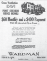
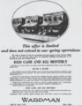
Wardman placed advertisements for the housing in local newspapers such as the Washington Post and Evening Star.[18] The advertisements centered on the houses' modern amenities as well as their low prices,[16] which were possible due to their mass production and Wardman's ownership of a planing mill and a woodworking company.[3] Wardman's advertisements highlighted the "select environment of a restricted community".[16] The first construction phases of houses were offered for sale from $6,750 to $7,150 each,[16] with payment plans available asking a $400 down payment and $65 each month thereafter.[19] The first model houses were located at 605 Rittenhouse Street[13] and 608 Roxboro Place.[20]
Advertisements
-
 Advertisement for Fort Stevens Ridge in The Washington Post, May 17, 1925.
 -
 Advertisement for Fort Stevens Ridge in The Washington Evening Star, August 1, 1925.
 -
 Advertisement for Fort Stevens Ridge in The Washington Evening Star, July 30, 1926.
 -
 Advertisement for Fort Stevens Ridge in The Washington Evening Star, December 4, 1926.
 -
 Advertisement for Fort Stevens Ridge in The Washington Evening Star, March 8, 1927.


References
- ^ ProQuest 149610386.
- ^ "Paving Georgia Avenue: 1,000 Houses to Be Built in New Section on Fort Stevens Ridge" (PDF). The Evening Star. August 30, 1924. p. 13.[permanent dead link]
- ^ ProQuest 149669583.
- ^ District of Columbia - New Ward 4 2010 Total Population by Census Block by Ward, ANC and SMD Boundaries Archived 2012-10-06 at the Wayback Machine. Office of Planning. Government of the District of Columbia. July 1, 2011.
- ^ a b Baist's Real Estate Atlas Surveys of Washington, District of Columbia, Volume 3, Plate 20 (Map). Baist, George William. 1894.
- ^ a b c Baist's Real Estate Atlas Surveys of Washington, District of Columbia, Volume 3, Plate 24 (Map). Baist, George William. 1903.
- ^ a b c Baist's Real Estate Atlas Surveys of Washington, District of Columbia, Volume 3, Plate 20 (Map). Baist, George William. 1919.
- ^ ProQuest 149694365.
- ^ ProQuest 149600926.
- ProQuest 149592118.
- ProQuest 149680303.
- ProQuest 149492344.
- ^ ProQuest 149496042.
- ^ ProQuest 149486855.
- ProQuest 149359908.
- ^ ProQuest 149602992.
- ProQuest 149518677.
- ^ "Fort Stevens Ridge" (PDF). The Evening Star. May 16, 1925. p. 19.[permanent dead link]
- ProQuest 149702728.
- ProQuest 149573258.
Further reading
- "Celebrating a Century of Wardman Row House Neighborhoods"[dead link]. Exhibition by the Historical Society of Washington, D.C. Carnegie Library Building, Washington, D.C., February 2007. Archived from the original Archived 2007-04-07 at the Wayback Machine on February 3, 2007.
- Fleishman, Sandra. "Wardman's World: Developer's Rowhouses Defined the District in the Early 20th Century and Are Still Prized Today", The Washington Post, October 15, 2005.
Nearby Neighborhoods in Washington, D.C. | ||||||||||||||||
|---|---|---|---|---|---|---|---|---|---|---|---|---|---|---|---|---|
| ||||||||||||||||