
Mount Pleasant (Washington, D.C.)
Mount Pleasant | |
|---|---|
Neighborhood of Washington, D.C. | |
_(cropped).jpg) .jpg) .jpg) 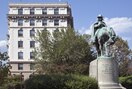 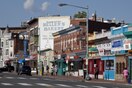 Top: Northwest | |
| Ward | 1 |
Mount Pleasant is a neighborhood in Washington, D.C., located in Northwest D.C. The neighborhood is primarily residential, with restaurants and stores centered along a commercial corridor on Mt. Pleasant Street. Mount Pleasant is known for its unique identity and multicultural landscape, home to diverse groups such as the punk rock, the Peace Corps and Hispanic Washingtonian communities.[1]
The neighborhood was initially developed around the
History
18th century
In 1727,
After the creation of the
In 1794 and 1796, noted Georgetown businessman Robert Peter conducted the first land surveys in the area and created maps for tracts of some of his land in Mount Pleasant for transactions with commissioners of the city.[4]
19th century
_(4119139914).jpg)
In 1861, William Selden, former Treasurer of the United States, owned 73 acres (300,000 m2) of land north of Pierce Mill Road, but having been a Confederate sympathizer, was forced was forced to sell his land at a low price and move back to Virginia. The purchaser was New England native Samuel P. Brown,[5] who built a house and also allowed the Mount Pleasant General Hospital to be constructed on his land.
After the American Civil War, Brown began selling his land in parcels. He named the area Mount Pleasant Village because it contained the land having the highest elevation within the original Pleasant Plains estate. Brown sold all of his land except for the parcel he retained around his house at 3351 Mount Pleasant Street, NW.[6]
In the 1870s, a horse-drawn
20th century
,_10-15-24_LCCN2016849651_(cropped).jpg)
In 1901,
In 1925, the city built the
By 1927, all homeowners in the neighborhood had signed
.jpg)
The neighborhood changed after the 1948 decision by the
Beginning in the 1960s and increasing through the 1980s, immigrants from Central America, particularly from Intipucá, El Salvador, settled in the neighborhood. The new residents developed businesses catering to Hispanic and Latino Americans along commercial portions of Mount Pleasant Street. The neighborhood also attracted former Peace Corps workers.
In 1973, the Community of Christ, a lay-led Lutheran group dedicated to social justice, bought a large building on Mount Pleasant Street and made it available rent-free to peace activists, pro-immigrant groups and musicians. In the 1980s, the group house scene flourished.[1]
However, from the 1970s to the 1990s, the neighborhood suffered from the crack epidemic and the illegal drug trade was rampant.[10]

In 1987, the neighborhood was designated as a historic district.
In May 1991, the
21st century
The 2010 United States census, the ZIP Code 20010, which includes Mount Pleasant, was one of the "most whitened" areas of the country, with the percentage of non-Hispanic white residents increasing from 22% in 2000 to 46.7% in 2010.[16]
As of 2021, housing prices had risen significantly.[17]
Geography
.jpg)
It is bounded by
Demographics

The population of Mount Pleasant, according to the 2010 census, was 10,459, down from 11,794 in 2000.
| 1990 | 2000 | 2010 | |
|---|---|---|---|
| white non-Hispanic | 35% | 35% | 50% |
| black non-Hispanic | 36% | 27% | 26% |
| Hispanic | 26% | 31% | 25% |
| Asian/Pacific Islander | 3.0% | 6.3% | 5.6% |
Incomes rose during this time period.
| 1979 | 1989 | 1999 | 2010 | |
|---|---|---|---|---|
| Average family income (2010 $) | $75,980 | $77,704 | $90,838 | $130,790 |
| Ratio to DC average | 98% | 83% | 89% | 114% |
Local institutions
.jpg)
The Mount Pleasant Historic District covers a variety of types and styles of building. The western portion of the neighborhood is a largely wooded residential enclave bounded on two sides by
The Eighteen Hundred Block Park Road, NW is notable for its 10 detached "suburban" houses on terraces overlooking the street.
The 12 buildings at 1644–1666 Park Road NW, designed by Appleton P. Clark Jr. in the style of Colonial Revival architecture, were completed in 1906.[9]
The Guglielmo Marconi Memorial is located at Marconi Plaza.
Education
.jpg)
- District of Columbia Public Schools operates the public schools.
- Bancroft Elementary School, 1755 Newton Street NW
- Private Religious Schools.
- Sacred Heart School, 1625 Park Road NW
District of Columbia Public Library operates the Mount Pleasant Library.[19]
Transportation
The neighborhood is served by the Mount Pleasant Line and the Crosstown Line buses. There is no Washington Metro station in the neighborhood, with the closest being located in Columbia Heights.[20]
Notable people

- Adrian Fenty, former mayor of Washington, D.C.
- Helen Hayes, actress
- Washington Senatorspitcher
- Sarah Doan La Fetra, temperance worker
- Suzanne La Follette, journalist and author
- Robert La Follette, politician
- Ian MacKaye, musician for Minor Threat and Fugazi
- Bob Mondello, film critic
References
- ^ a b c d e Morley, Jefferson (January 25, 2021). "The Mount Pleasant Miracle". The Washington Post.
- ^ Gentrifiers, distinction, and social preservation: A case study in consumption on Mount Pleasant Street in Washington, DC
- ^ Washington Post - The Mount Pleasant Miracle
- ISBN 0-8478-2447-0
- ^ "Mount Pleasant Historic District" (PDF).
- ^ "Village in the City". Cultural Tourism DC.
- ^ a b "The Architectural Legacy of Mount Pleasant Street" (PDF).
- ^ "FULTON R. GORDON AND ROBERT E. HEATER ARE Extending and Beautifying the Nation's Capital.: Virginians Make a Specialty of Opening New Northwest Suburban Property". The Washington Post. February 24, 1907.
- ^ a b "Mount Pleasant Historic District". National Park Service.
- ^ Dvorak, Petula (January 18, 2004). "In Mt. Pleasant, A Divided View On Street Crime". The Washington Post.
- ^ Orton, Kathy (April 5, 2013). "Mount Pleasant in Northwest Washington, D.C. offers a small-town feel". The Washington Post.
- ^ "National Register Information System". National Register of Historic Places. National Park Service. March 13, 2009.
- ^ Friedman, Emily (May 5, 2011). "Mount Pleasant Riots: May 5 Woven Into Neighborhood's History". WAMU.
- ^ Jones, Mark (April 28, 2015). "Mount Pleasant Boils Over, 1991". WETA.
- ^ Hermann, Peter (September 1, 2017). "Isaac Fulwood, Washington police chief during tumultuous era, dies at 77". The Washington Post.
- ^ DeBonis, Mike (June 11, 2012). "D.C. has three of America's most-whitened Zip codes". The Washington Post.
- ^ Wolfrom, Jessica (January 27, 2021). "Once a rural village, D.C.'s Mount Pleasant now an 'oasis in the city'". The Washington Post.
- ^ "Mount Pleasant Historic District nomination" (PDF).
- ^ "Mt. Pleasant Neighborhood Library". District of Columbia Public Library.
- ^ Washburn, Mark (February 14, 2023). "Why Mount Pleasant is One of the Coolest Neighborhoods in DC". DC CondoBoutique. Retrieved December 10, 2023.
External links
- Mount Pleasant Village
- Historic Mount Pleasant
- ANC1D, The Mount Pleasant Advisory Neighborhood Commission
- Why is It Named Mt. Pleasant?
Places adjacent to Mount Pleasant (Washington, D.C.) | ||||||||||||||||
|---|---|---|---|---|---|---|---|---|---|---|---|---|---|---|---|---|
| ||||||||||||||||
| International | |
|---|---|
| National | |