
Gibraltar Nature Reserve
| Gibraltar Nature Reserve | |
|---|---|
Gibraltar Ornithological and Natural History Society on behalf of the Government of Gibraltar | |
| Website | https://naturereserve.gi |
The Gibraltar Nature Reserve (formerly the Upper Rock Nature Reserve) is a protected nature reserve in the British Overseas Territory of Gibraltar that covers over 40% of the territory's land area. It was established as the Upper Rock Nature Reserve in 1993 under the International Union for Conservation of Nature's category Ia (strict nature reserve) and was last extended in 2013. It is known for its semi-wild population of Barbary macaques, and is an important resting point for migrating birds.
Location

Originally named the Upper Rock Nature Reserve, it was limited to the upper part of the
The Upper Rock area of the nature reserve can be reached by road or by the Gibraltar Cable Car, next to the Gibraltar Botanic Gardens.[4]
Designation
The reserve was established in 1993[2] to protect the area of land that the United Kingdom's Ministry of Defence had decommissioned from military use. Its purpose is to preserve the wildlife and natural and historical sites, while providing access to the public.[5] The flora and fauna of the nature reserve are protected by the law of Gibraltar.[6]
The nature reserve was last extended in 2013 when it was renamed the Gibraltar Nature Reserve to reflect its wider scope outside the Upper Rock. The protected area now covers the
Climate

Gibraltar has a typical Mediterranean climate, moderated by the sea that almost surrounds the peninsula. Summers are warm and dry, while winters are cool and wet. Temperatures range from 13.4 °C to 24.2 °C (56.1 °F to 75.6 °F). Annual rainfall is about 768 millimetres (30.2 in).[6] The Levanter clouds provide condensation that keeps the vegetation green even in the dry season.[5] These clouds form when moisture-laden easterly winds are forced upward by the cliffs of Gibraltar, and often form a cap over the Rock.[6]
Tourist attractions
The nature reserve contains many of Gibraltar's important natural history sites including caves such as St. Michael's Cave, with its many stalagmites and stalactites.[1] St. Michael's Cave was first mentioned by Pomponius Mela in 45 AD, and many sources have mentioned it since. It has become an important tourist attraction. Concerts are held in its main chamber.[7]
The Gibraltar Heritage Trust manages conservation of the historical sites and their development as tourist attractions. These include the O'Hara's Battery, 100 Ton Gun at Napier of Magdala Battery, Heritage Centre at Princess Caroline's Battery and the Parson's Lodge Battery.[5] Other military sites that are open to the public are the
Flora

In the past, the Upper Rock was tree-covered. Most of the trees were felled for fuel during the Great Siege of Gibraltar between 1779 and 1783. Trees today mostly produce berries that are eaten by birds, who presumably dropped their seeds on the rock. The most common is the
Gibraltar has more than six hundred species of flowering plants.[5] The
There are small areas of
Fauna

Mammals
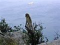
Mammals include the red fox, European rabbit and mouse-eared bat. The best-known residents are the Barbary macaques that make the reserve their home.[1] Gibraltar has a reintroduced population of Barbary macaques, the only wild primate species in Europe, the famous Rock apes.[13] The macaques may be found at the Ape's Den near the middle cable-car station, at the top cable car station, and near the Great Siege Tunnels.[14] As of 2012 there were from 200 to 250 macaques, all of them living in the nature reserve.[15] It is forbidden to feed the monkeys, but these rules have not always been followed. As a result, some of them have become aggressive and dependent on food from humans. In 2008 the government ordered a group of macaques to be culled that had taken to scavenging in the town centre.[16]
Reptiles
There are five species of lizard in the nature reserve, six snakes and an
Birds

The Rock of Gibraltar, at the head of the Strait, is a prominent headland, which accumulates migrating birds during the passage periods. The vegetation on the Rock, unique in southern Iberia, provides a temporary home for many species of migratory birds that stop to rest and feed before continuing migration for their crossing over the sea and desert. In spring, they return to replenish before continuing their journeys to Western Europe, journeys which may take them as far as Greenland or Russia.[citation needed]
The Rock has been identified as an Important Bird Area by BirdLife International because it is a migratory bottleneck, or choke point, for an estimated 250,000 raptors that cross the Strait annually, and because it supports breeding populations of Barbary partridges and lesser kestrels.[18]
Invertebrates
There are many insects in the reserve. In the late summer,
Gallery
- Animals of Gibraltar on Wikimedia Commons
-
 Northern peak of the Rock of Gibraltar
 -
 A Barbary macaque
 -
 View of the African coast
 -
 Top of the Charles V Wall


References
Citations
- ^ a b c d Upper Rock Nature Reserve - GTG.
- ^ a b c "Nature Conservation Area (Upper Rock) Designation Order 1993" (PDF). Government of Gibraltar. Retrieved 12 February 2014.
- ^ Perez & Bensusan 2005, p. 4.
- ^ Bryant 2007, p. 65.
- ^ a b c d Bennett & Doyle 1998, p. 109.
- ^ a b c Perez & Bensusan 2005, p. 3.
- ^ Bennett & Doyle 1998, p. 111-112.
- ^ a b Balter 2009.
- ^ Bennett & Doyle 1998, p. 112.
- ^ a b Perez & Bensusan 2005, p. 8.
- ^ a b Perez & Bensusan 2005, p. 7.
- ^ Perez & Bensusan 2005, p. 9.
- ^ Hogan 2008.
- ^ Simonis 2009, p. 766.
- ^ Chilton 2012, p. 171.
- ^ Inkson & Minnaert 2012, p. 264.
- ^ Perez & Bensusan 2005, p. 13-14.
- ^ GI001: Rock of Gibraltar.
- ^ Perez & Bensusan 2005, p. 14.
Sources
- Balter, Michael (22 September 2009). "When Darwin Met a Neandertal". American Association for the Advancement of Science. Archived from the original on 12 November 2012. Retrieved 17 October 2012.
- Bennett, Matthew R.; Doyle, Peter (1998). Issues in Environmental Geology: A British Perspective. Geological Society. ISBN 978-1-86239-014-0.
- Bryant, Sue (January 2007). Costa Del Sol. New Holland Publishers. ISBN 978-1-84537-636-9.
- Chilton, Glen (2012). The Attack of the Killer Rhododendrons: My Obsessive Quest to Seek Out Alien Species. HarperCollins. ISBN 978-1-4434-1147-9.
- "GI001: Rock of Gibraltar". Birdlife International. Retrieved 12 October 2012.
- Hogan, C. Michael (19 December 2008). "Barbary Macaque: Macaca sylvanus". GlobalTwitcher AB. Archived from the original on 19 April 2012. Retrieved 12 October 2012.
- Inkson, Clare; Minnaert, Lynn (2012). Tourism Management: An Introduction. SAGE Publications. ISBN 978-1-84860-870-2.
- Perez, Charles; Bensusan, Keith (2005). "A Guide to The Upper Rock Nature Reserve" (PDF). The Gibraltar Ornithological and Natural History Society. Archived from the original (PDF) on 10 May 2013. Retrieved 12 October 2012.
- Simonis, Damien (2009). Spain. Lonely Planet. ISBN 978-1-74179-000-9.
- "Upper Rock Nature Reserve". Gibraltar Travel Guide. Retrieved 12 October 2012.