
Heysham
| Heysham | ||
|---|---|---|
Shire county | ||
| Region | ||
| Country | England | |
| Sovereign state | United Kingdom | |
| Post town | MORECAMBE | |
| Postcode district | LA3 | |
| Dialling code | 01524 | |
| Police | Lancashire | |
| Fire | Lancashire | |
| Ambulance | North West | |
| UK Parliament | ||
Heysham (/ˈhiːʃəm/ ⓘ HEE-shəm) is a coastal village in the Lancaster district of Lancashire, England, overlooking Morecambe Bay. It is a ferry port, with services to the Isle of Man and Ireland, and the site of two nuclear power stations.
History
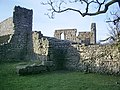
Of historical interest are the stone-hewn graves in the ruins of the ancient St. Patrick's Chapel, close to St Peter's Church. They are thought to date from the 11th century, and are carved from solid rock. Local legend has it that St Patrick landed here after crossing from Ireland and established the chapel. However it has been established that the chapel was built around 300 years after Patrick's death. These stone graves appear on the cover of the Black Sabbath CD, The Best of Black Sabbath.

The grounds of St Peter's Church contain many
Lancaster Museum holds artefacts from the area such as stone axe and hammer heads, some weighing up to 4 kg (9 lb), dating back to the
Heysham Heritage Centre is housed in the barn of a Longhouse in Main Street. The building is owned by the Heritage Trust for the North West, who also own the cottage part of the longhouse, 22 Main Street. The Heritage Centre is run by volunteers, most of whom belong to Heysham Heritage Association.[4]
Demography and governance
Administratively, Heysham is part of the City of Lancaster district and has three wards: Heysham Central (with a population of 4,397 in 2001,[5] increasing to 4,478 at the 2011 Census),[6] Heysham North (5,477 in 2001,[7] decreasing to 5,274 at the 2011 Census)[8] and Heysham South (6,262 in 2001,[9] increasing to 7,264 at the 2011 Census).[10] Together they had a population of 16,136 (2001 census), and 17,016 (2011 census). These include areas beyond the village of Heysham itself, which has a population of about 6,500.
Heysham North ward is within the area covered by Morecambe Town Council.[11][12]
From 1899 to 1928, Heysham was administered by Heysham Urban District Council,
Community
Heysham is the terminus of the Stanlow-Heysham
Industry and transport
Heysham oil refinery was located between Heysham and Middleton and operated from 1941 to 1976.
The Bay Gateway dual carriageway opened in October 2016, connecting Heysham directly to the M6 motorway.[16]
Nature and wildlife
The Lancashire Wildlife Trust manages a 3-hectare (7.4-acre) nature reserve near to the nuclear power stations.[17] Whitethroats breed on the scrubland. Nearby, on the sea shore is a patch of rock known as Red Nab where waders and gulls roost and congregate. Two warm water outfalls from the power stations enrich the food supply for migratory seabirds such as little gulls and Mediterranean gulls. Winter visitors include kittiwakes and purple sandpipers.[18]
Notable people
The artist J. M. W. Turner visited Heysham in the 1790s when travelling throughout Britain. On a visit in August 1816,[19] he made sketches which formed the basis of his subsequent watercolour Heysham and Cumberland Mountains (British Museum); it depicts the village with the Lakeland backdrop across Morecambe Bay.
Professional footballer David Perkins was born in Heysham.
Gallery
-
 Anglo-Saxon carved stone cross base
 -
-
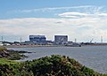
 Heysham Harbour
 -
-
 Sunset across 'The Barrows' on Heysham Nature Reserve
 -
 Faces of the hogback stone


See also
References
- S2CID 221713017.
- ^ Nash, George (2008). "The Heysham labyrinth, Morecambe Bay, northern England". Rock Art Research. 25 (2).
- ^ "The Labyrinth". rockartuk.wordpress.com. 13 October 2007. Archived from the original on 8 October 2015. Retrieved 31 December 2014.
- ^ "HHA". www.heyshamheritage.org.uk. Archived from the original on 4 August 2017. Retrieved 2 March 2017.
- ^ "Archived copy" (PDF). Archived from the original (PDF) on 13 February 2006. Retrieved 27 July 2006.
{{cite web}}: CS1 maint: archived copy as title (link) - Office for National Statistics. Retrieved 28 July 2023.
- ^ "Archived copy" (PDF). Archived from the original (PDF) on 13 February 2006. Retrieved 27 July 2006.
{{cite web}}: CS1 maint: archived copy as title (link) - Office for National Statistics. Retrieved 28 July 2023.
- ^ "Archived copy" (PDF). Archived from the original (PDF) on 13 February 2006. Retrieved 27 July 2006.
{{cite web}}: CS1 maint: archived copy as title (link) - Office for National Statistics. Retrieved 28 July 2023.
- ^ "Town Councillors". Morecambe Town Council. Archived from the original on 25 January 2024. Retrieved 25 January 2024.
- ^ "Morecambe Neighbourhood Area [map]" (PDF). Morecambe Town Council. Archived (PDF) from the original on 25 January 2024. Retrieved 25 January 2024.
- ^ "Heysham UD through time". A Vision of Britain through Time. GB Historical GIS / University of Portsmouth. Archived from the original on 25 January 2024. Retrieved 25 January 2024.
- ^ "Morecambe and Heysham MB through time". A Vision of Britain through Time. GB Historical GIS / University of Portsmouth. Archived from the original on 2 February 2023. Retrieved 25 January 2024.
- ^ "United Kingdom and Ireland Pipelines map". theodora.com. Archived from the original on 29 January 2017. Retrieved 31 December 2014.
- ^ "Heysham link road opens". ITV News. Archived from the original on 21 July 2019. Retrieved 26 July 2021.
- ^ "Heysham Nature Reserve | The Wildlife Trust for Lancashire, Manchester and North Merseyside". www.lancswt.org.uk. Archived from the original on 11 September 2023. Retrieved 29 July 2023.
- ISBN 978-1-871236-32-3– via Internet Archive.
- ^ In Turner's Footsteps, through the hills and dales of Northern England: David Hill : John Murray 1984
External links
| International | |
|---|---|
| National | |