
Padiham
| Padiham | ||
|---|---|---|
Shire county | ||
| Region | ||
| Country | England | |
| Sovereign state | United Kingdom | |
| Post town | BURNLEY | |
| Postcode district | BB12 | |
| Dialling code | 01282 | |
| Police | Lancashire | |
| Fire | Lancashire | |
| Ambulance | North West | |
| UK Parliament | ||

Padiham (
History
Early forms of the name include "Padingham", with the last element probably from the Old English word hām, meaning home and ing in this sense meaning "of the". Its first is generally thought to be a personal name (Bede listed Padda as one of the priests who assisted Bishop Wilfrid in the late 7th Century).[3][4]
No prehistoric or
Padiham's population peaked around 1921 at about 14,000, declining to 10,000 in the early 1960s and 8,998 at the time of the 2001 census.[7][8] This reflected how people were moving to the south of England in search of work, after the decline in the traditional cotton, coal and engineering manufacturing industries.
Governance
Padiham, once a
Councillors for Padiham on
Demography
According to the
The racial composition of the town in 2011 was 98.1% White (96.6% White British), 1.1% Asian, 0.1% Black, 0.5% Mixed and 0.1% Other. The largest religious groups were Christian (70.0%) and Muslim (0.6%). 68.3% of adults between the ages of 16 and 74 were classed as economically active and in work.[1]
| Year | 1901 | 1911 | 1921 | 1931 | 1939 | 1951 | 1961 | 2001 | 2011 | ||||||||||||
|---|---|---|---|---|---|---|---|---|---|---|---|---|---|---|---|---|---|---|---|---|---|
| Population | 12,205 | 13,635 | 12,471 | 11,633 | 10,011 | 10,041 | 9,899 | 8,998 | 10,098 | ||||||||||||
Economy
In the 19th century, Padiham's industry was based on
Industrial development was helped by proximity to the
Since the 1960s, the remaining cotton mills have continued a decline that began in the 1930s. So too has Padiham's role as a manufacturing base since the 1990s. The town's last major employer in the sector,
In 2007 Fort Vale Engineering developed a new purpose-built factory, where the old Mullard/Philips site at Calder Vale Park, Simonstone had closed in 2004. Fort Vale Engineering employs some 280 local people and has brought business to other local employers.
Landmarks
There are five significant mansions in the local area:

St Leonard's Parish Church dates from 1866 to 1869 and is a
Padiham Town Hall in Burnley Road, built in 1938 to designs by Bradshaw Gass & Hope, is a Grade II listed building.[39]
Padiham Memorial Park at the top of Church Street, was designed by
The park covers 12 acres (4.9 ha) on two sites divided by the River Calder. The upper section is mainly formal, dominated by Knight Hill House, currently used as an

Another locally listed building is the former Padiham Building Society headquarters. A detached building over two storeys with large underground vault on Burnley Road, constructed between 1955-1958 and officially opened in 1959. The building was recently renovated by local businessman Liam Veitch and converted into individual office spaces.
Padiham War Memorial itself is at the main park entrance in Blackburn Road.[45] There is a second memorial at All Saints' with St John the Baptist off the A671, Padiham Road, opposite the George IV pub.[46] A local man, Thomas Clayton, funded the park in his will; public subscription provided additional money for the park's many features.[47]
Near the war memorial, the Air Crash Memorial recalls several local young people killed on 3 July 1970, when a Dan Air
Several other buildings in the area are also of historic interest. Hargrove can be seen from a public footpath off the Padiham by-pass just north of the town and the 1950s council housing estate north of Windermere Road. For over 400 years it was the home of the Webster family of
Media
Local news and television programmes are provided by BBC North West and ITV Granada. Television signals are received from the Winter Hill TV transmitter and the local relay TV transmitter located in the Forest of Pendle.[52][53]
Local radio stations are
The town is served by the local newspapers, Burnley Express and Lancashire Telegraph.
Transport
Rail
Buses
The town is served by Burnley Bus Company services from Accrington, Burnley, Nelson, Colne and beyond,[55] and by a Blackburn Bus Company service 152 from Burnley, Blackburn and Preston.[56]
Road
Junctions 8 and 10 of the M65 are both some 2 miles (3 km) from the town centre. Junction 8 of the M65 also gives access to the A56 dual carriageway leading to the M66 and access to the Manchester motorway network.
Air
The nearest airport, Manchester, is 50 minutes' drive.[57] The best route by public transport is via Blackburn, then train. It takes some 2¼ hours.[58]
Historic maps
The 1845
The 1890 Ordnance Survey map (2) shows the cotton-industry growth of the cotton industry in the later 19th century. The 1–25,000 scale OS map (3) is a partial extract from the two maps indicated. Several historic locations shown include Read Hall (A2) and Read (B2); Martholme, just east of Martholme Viaduct (A3); Simonstone and Simonstone Hall (C3); Huntroyd and grounds (D1–D2); Padiham Power Station (D3) with the connecting line for fuel; post-war housing north of the town off Slade Lane (E2); High Whitaker (F1); the River Calder on the old course from Gawthore Hall and grounds (F2); Pendle Hall (G1); Ightenhill Manor House (G2); and the Leeds and Liverpool Canal in Burnley (J1). The railway line through Padiham also appears.
-
 1: Map of Padiham c. 1844
 -
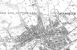 2: Ordnance Survey map dated 1890
 -
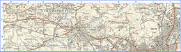 3: Extract from OS 1-25,000 scale maps SD73 (west section pub 1955) and SD83 (east section published 1954) showing historical locations around Padiham. Grid lines are 1 km.


Notable people
- Bill Blackadder (1899–1977), professional footballer
- William Blezard (1921–2003), composer born in Padiham, who worked with Joyce Grenfell and others
- Thomas Birtwistle (1833–1912), trade unionist involved in Padiham weavers' strikes in 1859
- Richard Bradshaw (fl. 1900s) footballer born in Padiham, played for Blackpool F.C.
- The Financial Times and The Daily Telegraph, was born in Padiham.
- WesleyanSchool.
- Harry Hastie (fl. 1920), footballer[60]
- Harry Hill (1916–2009), born in Padiham, was a bronze medallist at the 1936 Summer Olympics in Berlin.[61] Too poor to get to London any other way, Hill cycled the 200 miles from Sheffield on the bike he used in the Olympics.[62]
- University of St Mark & St John.
- Ughtred James Kay-Shuttleworth, 1st Baron Shuttleworth (1844–1939), Liberal politician, son of Sir James Kay-Shuttleworth. Under-Secretary of State for India and Chancellor of the Duchy of Lancaster under William Gladstone in 1886 and Parliamentary and Financial Secretary to the Admiralty under Gladstone and Lord Roseberyin 1892–1895. He inherited Gawthorpe on his mother's death in 1872.
- Charles Kay-Shuttleworth, 5th Baron Shuttleworth (born 1948), Lord Lieutenant of Lancashire for 1997
- John Starkie (1830–1888), landowner at Ashton Hall, Thurnham, Lancashire
- Le Gendre Starkie (1799–1865) and Le Gendre Starkie (1828–1899), landowners at Huntroyde
- William Thompson (1866–1920), cricketer
- Alfred Tysoe (1874–1901), Padiham-born athlete and winner of two gold medals in the 800m and 5,000m team races at the 1900 Olympic Games[63]
- Andy Payton (born 1967), professional footballer, nicknamed the Padiham Predator.
Freedom of the Town
The following have received the Freedom of the Town of Padiham.
Individuals
See also
References
Notes
- ^ The old township boundary with Hapton followed the River Calder and its tributary, Green Brook.[11]
Citations
- ^ Office for National Statistics. Retrieved 8 February 2018.
- ^ City Population cite. Retrieved 5 December 2020.
- ^ Bede (1903).
 Ecclesiastical History of the English People. Vol. 4. Translated by Jane, L.C. (Temple Classics ed.). London: J. M. Dent & Company. p. 14.
- ^ Ekwall, Eilert (1922). The place-names of Lancashire. Manchester University Press. pp. 12, 14, 22, 79–80. Retrieved 13 August 2023.
- ^ a b c d e Historic Town Assessment Report, Padiham, Lancashire County Council, May 2005, includes several old maps of the town and location of buildings – accessed 18 August 2011 Archived 1 October 2012 at the Wayback Machine
- OCLC 832215477
- ^ a b c "Padiham Ch/CP through time". visionofbritain.org.uk. GB Historical GIS/University of Portsmouth. Retrieved 18 October 2013.
- ^ 2001 census data. Accessed 8 December 2007.
- ^ British Pathé Newsreel 1995 Accessed 2014_02_01
- ^ "Northtown CP through time". visionofbritain.org.uk. GB Historical GIS/University of Portsmouth. Retrieved 18 October 2013.
- ^ Lancashire and Furness (Map) (1st ed.). 1: 10,560. County Series. Ordnance Survey. 1848.
- ^ "The Burnley (Parish) Order 2001" (PDF). Secretary of State for the Environment, Transport and the Regions. 20 December 2001. Retrieved 11 April 2021.
- ^ "Padiham Town Council – About us". Padiham Town Council. Archived from the original on 19 October 2013. Retrieved 13 October 2013.
- ^ "Burnley (Parishes) Order 2004" (PDF). Office of the Deputy Prime Minister. 27 January 2004. Archived from the original (PDF) on 16 January 2018. Retrieved 27 February 2021.
- ^ "Gawthorpe". Ordnance Survey Linked Data Platform. Ordnance Survey. Retrieved 6 January 2016.
- ^ "Hapton with Park". Ordnance Survey Linked Data Platform. Ordnance Survey. Retrieved 6 January 2016.
- ^ "Your Councillors". burnley.moderngov.co.uk. Burnley Borough Council. Retrieved 5 August 2023.
- ^ "County Councillors by Local Community". Lancashire County Council. Retrieved 5 August 2023.
- ^ a b "Parish headcount" (PDF). Lancashire County Council. Archived from the original (PDF) on 10 December 2006. Retrieved 25 July 2009.
- ^ Table KS01 Usual resident population, Office for National Statistics, archived from the original on 23 July 2004, retrieved 9 August 2014
- Office for National Statistics. Retrieved 6 March 2021.
- ^ "Padiham UD through time". visionofbritain.org.uk. GB Historical GIS / University of Portsmouth. Retrieved 22 March 2021.
- ^ ISBN 978-0-300-12667-9.)
{{cite book}}: CS1 maint: multiple names: authors list (link - ISBN 9780859679008.
- ^ Report on Trade Unions in 1905–1907. London: Board of Trade. 1909. pp. 82–101.
- ^ Padiham Life Archived 28 August 2008 at the Wayback Machine
- ^ 'Job Threat After Factory Closure' , BBC News website 15 March 2007. Accessed 14 January 2008.
- ^ Shuttleworth Mead Business Park. Accessed 5 September 2008.
- ^ Lancashire County Council proposals for public footpath July 2009, Accessed 11 February 2010 Archived 4 August 2012 at archive.today
- ^ North West Regional Development Agency. Accessed 6 September 2008
- ^ a b Parks and Gardens UK – based on the English Heritage Register of Parks and Gardens of Special Historic Interest Archived 26 February 2012 at the Wayback Machine
- ^ National Trust Website, accessed 2 October 2008 Archived 21 September 2008 at the Wayback Machine
- ^ Searchable guide to country houses, includes Gawthorpe and other houses owned by the Shuttleworths – accessed 18 April 2010 Archived 4 February 2004 at the Wayback Machine
- ^ www.genuki.org.uk Accessed 13 November 2007.
- ^ Grimshaw and Shuttleworth family origin website, accessed 15 January 2011 Archived 28 December 2012 at the Wayback Machine
- ISBN 978-0-300-12667-9.)
{{cite book}}: CS1 maint: multiple names: authors list (link - ^ Lancashire Family History & Heraldry Society. Accessed 13 November 2007.
- ^ a b Armstrong, Duncan (1985). "Owd Padiham" – a pictorial history. Padiham: Mercer Print.
- ^ Lancashire County Council Library and Information Service Archived 19 April 2008 at the Wayback Machine Accessed 25 February 2008.
- ^ Burnley Borough Council report on restoration of Padiham Memorial Park Archived 15 June 2011 at the Wayback Machine. Accessed 28 July 2009
- ^ Parks and Gardens register UK – the park had not been surveyed at the time the data was accessed − 3 February 2010. Archived 11 March 2012 at the Wayback Machine
- ^ Lancashire Gardens Trust. Accessed 17 April 2010.
- ^ Green Flag Award Scheme Archived 7 February 2008 at the Wayback Machine Accessed 27 February 2008.
- ^ "World War II Air Raid shelters in Memorial Park". Retrieved 19 January 2009.
- ^ "World War I Cemeteries, Padiham War memorial (includes WWII)". Archived from the original on 4 October 2008. Retrieved 19 January 2009.
- ^ "World War memorial at All Saints with St John the Baptist, BB12 6PA (includes WWII)". Archived from the original on 5 October 2008. Retrieved 19 January 2009.
- ^ Burnley Borough Council Archived 14 September 2007 at the Wayback Machine. Accessed 28 February 2008.
- ^ "Air Crash Memorial, Padiham Memorial Park looking west in the direction of Blackburn". Retrieved 19 January 2009.
- ^ "Dan Air, air crash, northern Spain, Friday, 3 July 1970". Retrieved 19 January 2009.
- ^ "BBC on this day, Friday, 3 July 1970". BBC News. 3 July 1970. Retrieved 19 January 2009.
- ^ ISBN 978-0-7524-5188-6.
- ^ "Full Freeview on the Winter Hill (Bolton, England) transmitter". UK Free TV. Retrieved 1 January 2024.
- ^ "Full Freeview on the Pendle Forest (Lancashire, England) transmitter". UK Free TV. Retrieved 1 January 2024.
- ^ "North West Radio Stations". Retrieved 1 January 2024.
- ^ Mainline bus services Archived 22 August 2007 at the Wayback Machine
- ^ Lancashire United Bus Service
- ^ www.theaa.com The AA route planning. Accessed 8 February 2010.
- ^ Journey planner direct website Archived 13 June 2014 at the Wayback Machine
- ^ Detailed version of map at the Lancashire County Council website
- ^ Michael Joyce, 2004, Football League Players' Records 1888–1939.
- ^ Sports Reference, accessed 28 September 2010.
- ^ "Goodbye to a true cycling superstar". Radcliffe. Bury Times. 5 February 2009.
- ^ Sports Reference website, accessed 28 September 2010.
- ^ Plunkett, Susan (29 June 2021). "Well loved 'Mr Padiham' receives surprise Freedom of the Town award at ceremony to mark 100th anniversary of park". Burnley Express. Retrieved 29 June 2021.
- ^ Plunkett, Susan (29 June 2021). "In pictures: Freedom of Town honour for 'Mr Padiham' at unveiling of memorial stone to mark 100th birthday of popular park". Burnley Express. Retrieved 29 June 2021.
External links
- Burnley Borough Council
- Church of England Parish of Padiham and Hapton
- Padiham Town Council
- Visit Padiham
- Padiham Urban District Council archive catalogue
- Padiham Heritage Appraisal 2015
- Map sources for Padiham
Geography of the Borough of Burnley | |||||||
|---|---|---|---|---|---|---|---|
| Towns |  | ||||||
| Villages & suburbs |
| ||||||
| Parishes | |||||||
| Topography |
| ||||||
| International | |
|---|---|
| National | |
| Geographic | |