
Jabuka, Pančevo
Jabuka
Јабука | |
|---|---|
|
UTC+2 (CEST) | |
| Postal code | 26201 |
| Area code | +381(0)13 |
| Car plates | PA |
Jabuka (
Name
Jabuka or Јабука means '
Geography
Jabuka is located on flat and fertile plain nearby
History


In the 1970s, scientific staff of
The communal area was part of
According to legend, first published in print in 1912, Jabuka was founded in the late 17th and early 18th century by Serbian fishermen who settled near an apple tree on the left bank of the
actual historical record of founding by first settlers.The modern village of Jabuka was founded by
In 1921, population of village numbered 3,265 inhabitants, including 2,819
During the
In the time period after World War II the village was settled with families from Macedonia, many of them originating from Kriva Palanka Municipality. In 1948, the majority of inhabitants were Macedonians (2,806 or 63.88%).[13][14]
| Year | Pop. | ±% |
|---|---|---|
| 1948 | 4,392 | — |
| 1981 | 6,453 | +46.9% |
| 2002 | 6,312 | −2.2% |
Topographic history
On 9 May 1768,
From 1959 to 1960, the old
In 1901, the small
Economy
The main occupation of the people is in agriculture, as with many other local settlements. However, many of the inhabitants also work in the factories of the neighbouring city of Pančevo. There is an industrial starch factory on the municipal area.[30]
Culture
Given that Jabuka was mostly populated with
In 2001, local Romani people have formed the association Crni Biseri (Black Pearls). In 2007, some residents founded the cultural and artistic society KUD Vasil Hadžimanov.[32][33]
Sports
There is a football club named OFK Jugoslavija in the village. It was founded in 1935 and its club colors are blue and white. Since 1998, there is a handball club (Rukometni Klub) named RK Jabuka.[34][35]
Gallery
-
 National Archives of Austria, Map of the Josephinian Land Survey (1769–1772)
 -
 Roman Catholic Church Saint Leopold
 -
 School Gotse Delchev, built in 1912
 -
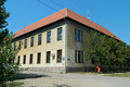
 Part of modern school extension with sports hall, built 1960–1961; snapshot of 2006
 -
 Orthodox churchSaint Elijah


.png)


See also
- List of cities, towns and villages in Vojvodina
- List of places in Serbia
- Macedonians in Serbia
References
- ^ "Насеља општине Панчево" (PDF). stat.gov.rs (in Serbian). Statistical Office of Serbia. Archived from the original (PDF) on 14 November 2015. Retrieved 24 October 2019.
- ^ Samu Borovszky, Magyarország vármegyéi és városai. Torontal vármegye, Budapest 1912, p. 124.
- ISBN 3-8258-5975-4, pp. 188–189.
- ^ Simo Mladenovski, Banatsko selo Jabuka, Skopje 1989, p. 19-24.
- ^ Samu Borovszky, Magyarország vármegyéi és városai. Torontal vármegye, Budapest 1912, p. 124.
- ^ Simo Mladenovski, Banatsko selo Jabuka, Skopje, 1988.
- ^ Dr Slobodan Ćurčić, Naselja Banata - geografske karakteristike, Novi Sad, 2004.
- ^ Opšta državna statistika, Definitivni rezultati popisa stanovništva od 31 januara 1921 godine, Sarajevo 1932, p.354-355.
- ISBN 978-86-87881-04-4.
- ISBN 9783486595826.
- ^ Christine Mergel, Josef Jerger, Stefan Metha and Mathias Ulrich, Heimatbuch der Ortsgemeinde Jabuka Torontalalmas Apfeldorf, Ludwigshafen 1990.
- ^ Ljubiša Ivanovski, Jabuka kroz vekove, Pančevo 2011.
- ^ Savezni zavod za statistiku, Konačni rezultati popisa stanovništva od 15 Marta 1948 godine, vol. 9, Belgrade 1954, p. 338.
- ^ Simo Mladenovski, Banatsko selo Jabuka, Skopje 1988, pp. 88–90.
- ^ Felix Milleker, Geschichte der Banater Militärgrenze 1764-1873, Wittigschlager Pančevo 1925, p. 49.
- ^ Map of Jabuka in 1774, Plan G I h 3 of the Maps and Plan Collection by National Archives of Austria and the Institute of Military History Budapest on the Website of Hungarian Cultural Heritage Portal, retrieved on 2018-02-20.
- ^ Vaterländische Blätter für den österreichischen Kaiserstaat, Volume 1, Vienna 1810, p. 191 on Google Books.
- ^ Carl Bernhard von Hietzinger, Statistik der Militärgrenze, Volume 2, Vienna 1820, page 92 on Google Books.
- ^ Franz Vaníček, Specialgeschichte der Militärgrenze, Volume 4, Vienna 1875, p. 280 on Google Books.
- ^ Historical Map of Franciscan Land Survey (1806-1869), Retrieved on 2018-01-03.
- ^ Cadastre maps Jabuka (Hungarian Almás), Retrieved on 2018-01-03.
- ^ Magyar Király Központi Statisztikai Hivatal, A magyar szent korona országainak 1910. évi népszámlálása, Budapest 1912, Volume 42, p. 369 on the Website of Hungarian Cultural Heritage Portal, retrieved on 2018-01-09.
- ISBN 978-86-87881-04-4, p. 56.
- ^ Christine Mergel, Josef Jerger, Stefan Metha and Mathias Ulrich, Heimatbuch der Ortsgemeinde Jabuka Torontalalmas Apfeldorf, Ludwigshafen 1990, p. 151.
- ISBN 978-86-87881-04-4, p. 56.
- ^ Magyar Király Statisztikai Hivatal, A magyar korona országainak helységnévtára, Budapest 1892, p. 606 (369 Vlachs and 13 Serbs) on the Website of Hungarian Cultural Heritage Portal, retrieved on 2018-01-08.
- ^ Hof- und Staats-Handbuch der österreichisch-ungarischen Monarchie für 1877, Vienna 1877, p. 828 on Google Books.
- ^ Report on the consecration by RTV Pančevo on YouTube, retrieved on 2017-12-25.
- ^ Official Website by Osnovna škola Jabuka, retrieved on 2017-12-25.
- ^ Official Website by Jabuka Starch Industry of Pančevo (in English), Retrieved on 2017-01-06.
- ^ Makedonska kuka za makedoncite vo Jabuka (Pančevo), article on the Website by Makedonska nacija (in Macedonian), Retrieved on 2017-01-03.
- ^ Notification about DRUŠTVO ROMA CRNI BISERI JABUKA on Bisnode, retrieved on 2017-11-07.
- ^ KUD Vasil Hadžimanov on Facebook and Notification on Bisnode, retrieved on 2018-01-08.
- ^ Official Website by OFK Jugoslavija Jabuka on Facebook (in Serbian), Retrieved on 2017-01-06.
- ^ Notification about RK Jabuka on Bisnode, retrieved on 2017-12-11.
External links
- Jabuka on the Official Website by the Municipality of Pančevo (in Serbian)