
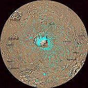
Mare Australe quadrangle
 Map of Mare Australe quadrangle from Mars Orbiter Laser Altimeter (MOLA) data. The highest elevations are red and the lowest are blue. | |
| Coordinates | 75°S 0°E / 75°S 0°E |
|---|---|

The Mare Australe quadrangle is one of a series of
Notable features
Around the southern ice cap is a surface, called the Dorsa Argentea Formation that may be an old ice-rich deposit. It contains a group of sinuous, branched ridges that resembles eskers that form when streams are under glaciers.[5] The formation often contains pits: two major locations are named Cavi Angusti and Cavi Sisyphi. The pits have steep sides and an irregular shape. They are up to 50 km across and 1 km deep.[6]
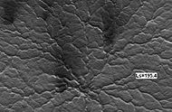
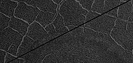
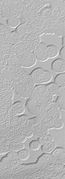
The quadrangle also contains Angustus Labyrinthus, a formation of intersecting valley or ridges, nicknamed the "Inca City".[7] Researchers were surprised to see parts of the surface having a Swiss-cheese appearance. Also, some areas showed strange spider-shaped forms, which were determined to be caused by carbon dioxide gas blowing dust around at certain times of the year.
Some craters in Mare Australe show gullies.
Freezing of atmosphere
Research based on slight changes in the orbits of spacecraft around Mars over 16 years found that when one hemisphere experiences winter, approximately 3 trillion to 4 trillion tons of carbon dioxide freezes out of the atmosphere onto the northern and southern polar caps. This represents 12 to 16 percent of the mass of the entire Martian atmosphere. These observation support predictions from the Mars Global Reference Atmospheric Model—2010.[17][18]
Lake of liquid water
Scientists reported in July 2018, the discovery of a lake of liquid water under the southern ice cap. The measurements were gathered with the Mars Advanced Radar for Subsurface and Ionosphere Sounding (MARSIS) on board the European Space Agency's orbiting Mars Express spacecraft. Radar reflections showed a bright spot in the ice layers that analysis later showed that it had to be a lake of liquid water. It is believed that the water remains liquid, even at the temperature of -68 degrees Celsius because there is likely much dissolved salt that lowers the freezing point. The lake is about 20 kilometers across and at least 10 centimeters deep It could contain 10 billion liters of liquid water.[19][20] There could very well be many small bodies of water under the ice cap; however, they are difficult to detect with MARSIS. Also, the raw date coverage needed for these detections is limited—only a few percent of the area has a full set of data.[20]
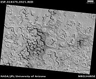
Spiders
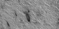
During the winter, much frost accumulates. It freezes out directly onto the surface of the permanent polar cap, which is made of water ice covered with layers of dust and sand. The deposit begins as a layer of dusty CO
2 frost. Over the winter, it recrystallizes and becomes denser. The dust and sand particles caught in the frost slowly sink. By the time temperatures rise in the spring, the frost layer has become a slab of semi-transparent ice about 3 feet thick, lying on a substrate of dark sand and dust. This dark material absorbs light and causes the ice to sublimate (turn directly into a gas) below the surface. Eventually much gas accumulates and becomes pressurized. When it finds a weak spot, the gas escapes and blows out the dust.[21] Speeds can reach 100 miles per hour.[22] Dark channels can sometimes be seen; they are called "spiders".[23][24][25][26][27][28] The surface appears covered with dark spots when this process is occurring.[22][29] The official name for spiders is "araneiforms".[30] These features can be seen in some of the pictures below.
-
 Star burst Channels caused by escaping gas, as seen by HiRISE. Star burst channels, also called spiders, may be about 500 meters in diameter and 1 meter deep.
 -
 Spider on the second Martian day of spring, as seen by HiRISE
 -
 Some spider 14 Martian days later, as seen by HiRISE. Notice increased dark fans caused by outgassing of carbon dioxide and dark material.
 -
 Old spiders, as seen by HiRISE under HiWish program
 -
 Wide view of plumes, as seen by HiRISE under HiWish program. Many of the plumes show spiders when enlarged.
 -
 Plumes, as seen by HiRISE under HiWish program. Arrow shows a double plume. This may have been because of shifting winds.
 -
 Long plume, as seen by HiRISE under HiWish program
 -
 Spiders, as seen by HiRISE under HiWish program
 -
 Plumes and spiders, as seen by HiRISE under HiWish program
 -
 Plumes and spiders, as seen by HiRISE under HiWish program
 -
 Plumes and spiders, as seen by HiRISE under HiWish program
 -
 Wide view of plumes and spiders, as seen by HiRISE under HiWish program
 -
 Plumes and spiders, as seen by HiRISE under HiWish program


-
 Wide view of crater that contains examples of spiders, as seen by HiRISE under HiWish program. Close views of some of the spider formations are shown in following images.
 -
 Close view of spider formations, as seen by HiRISE under HiWish program. The polygon shapes are channels caused by pressurized carbon dioxide going through cracks. During the winter season, a slab of dry ice forms on the ground surface. The surface contains cracks in the shape of polygons. During certain times, CO2 under the ice becomes pressurized from sunlight penetrating the slab of dry ice. As the gas moves around the channels become larger.
 -
 Close view of spider formations, as seen by HiRISE under HiWish program. Polygon-shaped channels are also visible.


Defrosting
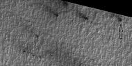
As the temperature warms and more sunlight becomes available in the spring, frost starts to disappear. This process begins with the appearance of dark spots. By the time the temperature rises to the melting point of water ice, all ice is gone. The process was first followed with repeated images by the Mars Global Surveyor.[31][32] With the much greater resolution of HiRISE, it was seen that many spots had the shape of fans. Some of these spots and fans are visible in the pictures below. Thousands of fans were examined by a Citizen Science project. Nearly all (96%) of the fans measured in this study have a length below 100 m. The average fan length is at 33.1 m. The three largest fans lengths of 373 m, 368 m and 361 m and were all in the same region.[33]
-
 Wide view of defrosting, as seen by HiRISE under HiWish program. Gas and dark dust is probably being blown out of ground and then carried by winds toward the Northwest.
 -
 Close view of defrosting, as seen by HiRISE under HiWish program. Gas and dark dust is probably being blown out of ground and then carried by winds toward the Northwest. Arrow points to a possible spider formation.
 -
 Close view of defrosting, as seen by HiRISE under HiWish program. Gas and dark dust is probably being blown out of ground and then carried by winds toward the Northwest.
 -
 Close view of defrosting, as seen by HiRISE under HiWish program. Gas and dark dust is probably being blown out of ground and then carried by winds toward the Northwest.


-
 Wide view of spring defrosting. The dark spots are where the ice has disappeared, thus revealing the dark surface beneath the ice. Picture taken with HiRISE under HiWish program.
 -
 Close view of spring defrosting. The dark spots are where the ice has disappeared, thus revealing the dark surface beneath the ice. Picture taken with HiRISE under HiWish program.


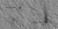
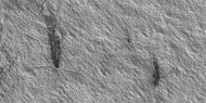
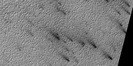
Dust devil tracks
Many areas on Mars, including Eridania, experience the passage of giant
Dust devils occur when the sun warms up the air near a flat, dry surface. The warm air then rises quickly through the cooler air and begins spinning while moving ahead. This spinning, moving cell may pick up dust and sand then leave behind a clean surface.[34]
Dust devils have been seen from the ground and high overhead from orbit. They have even blown the dust off of the
A study that combined data from the High Resolution Stereo Camera (HRSC) and the Mars Orbiter Camera (MOC) found that some large dust devils on Mars have a diameter of 700 meters and last at least 26 minutes.[37]
-
 Dust Devil, as shown from HiRISE. Dust devil is moving to the upper left, leaving a dark track to the lower right. The shadow of the dust devil is to the upper left of the dust devil.
 -
 Weinbaum (crater), as seen by CTX camera (on Mars Reconnaissance Orbiter)
 -
 Weinbaum crater region showingdust devil tracks, as seen by CTX camera (on Mars Reconnaissance Orbiter). Field of picture is just outside rim of crater and is an enlargement of the previous image of Weinbaum crater.
 -
 Western side ofMitchel crater, as seen by CTX camera (on Mars Reconnaissance Orbiter)
 -
 Dust devil tracksin Mitchell crater, as seen by CTX camera (on Mars Reconnaissance Orbiter). Note: this is an enlargement of a previous image of west side of Mitchel crater.
 -
 Schmidt (Martian crater), as seen by CTX camera (on Mars Reconnaissance Orbiter). Arrows indicate the north and south rims of crater.
 -
 Dunes anddust devil tracksin Schmidt crater, as seen by CTX camera (on Mars Reconnaissance Orbiter). Narrow, dark lines are dust devil tracks. Note: this is an enlargement of the previous image of Schmidt crater.
 -
 Dust devil tracks and layers, as seen by HiRISE under HiWish program


Dorsa Argentea Formation
The
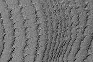
This group of ridges extends from 270–100 E and 70–90 S, around the south pole of Mars. It sits under the Late Amazonian South Polar Layered Deposits (SPLD). The amount of these ridges is huge, one study studied seven different ridge systems which contained almost 4,000 ridges that had a total length 51,000 km.[51]
Most eskers are thought to be formed inside ice-walled tunnels by streams which flowed within and under glaciers. After the retaining ice walls melted away, stream deposits remained as long winding ridges.
MARSIS radar data suggest that significant areas of layered, potentially ice-rich parts of the Dorsa Argentea Formation remain today.[52][53][54]
-
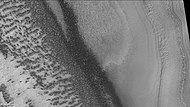
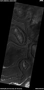
 Ridges, believed to be eskers of the Dorsa Argentea Formation, as seen by Mars Global Surveyor wide angle MOC. White arrows point to the ridges.

A team of researchers used an early Mars global climate model together with the University of Maine Ice Sheet Model to determine how the eskers formed. They concluded that to get enough a high enough temperature in the Martian atmosphere to form the ice sheet, a greenhouse gas in addition to a thicker carbon dioxide atmosphere was needed to warm the surface near the poles by at least 20 degrees C. Also, to produce the shape of the ice sheet, at least part of the Tharsis volcanoes needed to be present.[55]
Proof for ocean
Strong evidence for a one time ancient ocean was found from data gathered from the north and south poles. In March 2015, a team of scientists published results showing that this region was highly enriched with deuterium, heavy hydrogen, by seven times as much as the Earth. This means that Mars has lost a volume of water 6.5 times what is stored in today's polar caps. The water for a time would have formed an ocean in the low-lying Mare Boreum. The amount of water could have covered the planet about 140 meters, but was probably in an ocean that in places would be almost 1 mile deep.
This international team used ESO’s Very Large Telescope, along with instruments at the W. M. Keck Observatory and the NASA Infrared Telescope Facility, to map out different forms of water in Mars’s atmosphere over a six-year period.[56][57]
Craters
-
 Map of Mare Australe with major features labeled
 -
 Hutton CraterArea, as seen by HiRISE. Click on image to see patterned ground.
 -
 Phillips CraterArea, as seen by HiRISE
 -
 Suess (Martian crater), as seen by CTX camera (on Mars Reconnaissance Orbiter)
 -
 East side ofStoney (Martian crater), as seen by CTX camera (on Mars Reconnaissance Orbiter).
 -
 Reynolds (crater), as seen by CTX camera (on Mars Reconnaissance Orbiter).
 -
 East side ofHolmes (crater), as seen by CTX camera (on Mars Reconnaissance Orbiter).
 -
 Western side ofSteno (Martian crater), as seen by CTX camera (on Mars Reconnaissance Orbiter).
 -
 Pityusa Patera, as seen by HiRISE.


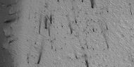
Craters showing layers
Many places on Mars show rocks arranged in layers. The study of layering on Mars greatly expanded when the Mars Global Surveyor sent back images.[58][59] Rock can form layers in a variety of ways. Volcanoes, wind, or water can produce layers.[60][61][62] A detailed discussion of layering with many Martian examples can be found in Sedimentary Geology of Mars.[63] A paper by Grotzinger and Milliken discusses the role of water and wind in forming layers of sedimentary rocks.[64] Since craters are low spots on the landscape material can more easily accumulate there and may resist erosion longer than other places.
-
 Close-up of Layers in wall ofMcMurdo Crater, as seen by HiRISE
 -
 Smith Crater, as seen by CTX camera (on Mars Reconnaissance Orbiter)
 -
 Dust devil tracksin Smith Crater, as seen by CTX camera (on Mars Reconnaissance Orbiter). Note: this is an enlargement of the previous image of Smith Crater.
 -
 eskerswhich formed under glaciers.
 -
 Close up of eskers in Lau Crater, as seen by CTX camera (on Mars Reconnaissance Orbiter). The dark lines are dust devil tracks. Note: this is an enlargement of the previous image of Lau Crater.
 -
 Heaviside Crater, as seen by CTX camera (on Mars Reconnaissance Orbiter).
 -
 Gullies in a crater that is on the floor of Heaviside Crater, as seen by CTX camera (on Mars Reconnaissance Orbiter). Note: this is an enlargement of the previous image of Heaviside Crater.
 -
 Liais (crater), as seen by CTX camera (on Mars Reconnaissance Orbiter)
 -
 Layers is Liais crater, as seen by CTX camera (on Mars Reconnaissance Orbiter). Note: this is an enlargement of the previous image of Liais crater.
 -
 East side of South crater, as seen by CTX camera (on Mars Reconnaissance Orbiter)
 -
 Layers in southern part of mound in South crater, as seen by CTX camera (on Mars Reconnaissance Orbiter). Note: this is an enlargement of the previous image of east side of South crater.
 -
 Layers just outside the rim of South crater in the form of "Swiss cheese", as seen by CTX camera (on Mars Reconnaissance Orbiter). Note: this is an enlargement of a previous image of east side of South crater.
 -
 Western side of South crater, as seen by CTX camera (on Mars Reconnaissance Orbiter)
 -
 Layers in mound in western side of South crater, as seen by CTX camera (on Mars Reconnaissance Orbiter). Note: this is an enlargement of a previous image of west side of South crater.
 -
 Layers just outside rim of western side of South crater in the form of "Swiss cheese", as seen by CTX camera (on Mars Reconnaissance Orbiter). Note: this is an enlargement of a previous image of west side of South crater.
 -
 Rayleigh (Martian crater), as seen by CTX camera (on Mars Reconnaissance Orbiter)
 -
 Layers in Rayleigh crater, as seen by CTX camera (on Mars Reconnaissance Orbiter). Note: this is an enlargement of the previous image of Rayleigh crater.


Craters showing defrosting in spring
-
 West side of Main crater, as seen by CTX camera (on Mars Reconnaissance Orbiter)
 -
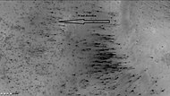 Dust trails in Main crater, as seen by CTX camera (on Mars Reconnaissance Orbiter). Arrow indicates wind direction. In the spring, as the temperature rises, dry ice turns into a pressurized gas, and then blows through a weak spot and carries with it dust. If there is a wind, the dust is deposited in an elongated form as in this image.
 -
 Richardson Crater, as seen by CTX camera (on Mars Reconnaissance Orbiter)
 -
 Dunes and defrosting spots in Richardson Crater, as seen by HiRISE. It is thought that films of liquid water sometimes exist in and around the dark spots.
 -
 Jeans (Martian crater), as seen by CTX camera (on Mars Reconnaissance Orbiter).
 -
 Jeans crater showing layers and dark spots from frost disappearing, as seen by CTX camera (on Mars Reconnaissance Orbiter). Note: this is an enlargement of the previous image of Jeans crater.
 -
 Playfair (Martian crater), as seen by CTX camera (on Mars Reconnaissance Orbiter). Dark dots are places where frost has disappeared.
 -
 Defrosting going on in Playfair crater, as seen by CTX camera (on Mars Reconnaissance Orbiter). Dark areas are where frost has disappeared thereby showing dark ground. Note: this is an enlargement of the previous image of Playfair crater.
 -
 Lyell (Martian crater), as seen by CTX camera (on Mars Reconnaissance Orbiter)
 -
 Gullies in Lyell crater, as seen by CTX camera (on Mars Reconnaissance Orbiter). Note: this is an enlargement of the previous image of Lyell crater.
 -
 Defrosting taking place in Lyell crater, as seen by CTX camera (on Mars Reconnaissance Orbiter). Dark areas are where frost has disappeared thereby showing dark ground. Note: this is an enlargement of a previous image of Lyell crater.
 -
 West side of Joly (crater), as seen by CTX camera (on Mars Reconnaissance Orbiter)
 -
 Dark spots and "spiders" in Joly crater, as seen by CTX camera (on Mars Reconnaissance Orbiter). "Spiders" appear as fuzzy spots; they are where dark dust is accumulating in channels below clear slabs of frozen carbon dioxide. Note: this is an enlargement of the previous image of Joly crater.
 -
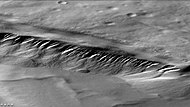
 Eskers in Joly crater, as seen by CTX camera (on Mars Reconnaissance Orbiter). Eskers are the ridges in the image; they are formed by streams running under a glacier.
 -
 Reynolds crater showing streaks from defrosting, as seen by CTX camera (on Mars Reconnaissance Orbiter). Layers are also visible. Note: this is an enlargement of the previous image of Reynolds crater. Streaks are caused by pressurized carbon dioxide blowing out dust that is blown by the wind into streaks.
 -
 Reynolds crater showing layers and dark spots from defrosting, as seen by CTX camera (on Mars Reconnaissance Orbiter). Area is covered by frost, when the frost disappears the underlying dark ground is exposed. Layers are also visible. Note: this is an enlargement of a previous image of Reynolds crater.


Polygons
Much of the surface of Mars shows the ground arranged into polygons of various sizes. Sometimes, during the right season the lows areas of polygons are full of frost. When this happens, the shapes are enhanced forming beautiful views.
-
 Wide view of crater containing polygons with frost in the low parts, as seen by HiRISE under the HiWish program
 -
 Closer view of polygons with frost in the low parts, as seen by HiRISE under the HiWish program
 -
 Still closer view of polygons, as seen by HiRISE under the HiWish program
 -
 Close view of polygons with frost in the low parts, as seen by HiRISE under the HiWish program. Circular shapes are also visible.


Swiss Cheese Terrain
Parts of Mare Australe display pits that make the surface look like Swiss cheese.[65][66][67][68] These pits are in a 1-10 meter thick layer of dry ice that is sitting on a much larger water ice cap. Pits have been observed to begin with small areas along faint fractures. The circular pits have steep walls that work to focus sunlight, thereby increasing erosion. For a pit to develop a steep wall of about 10 cm and a length of over 5 meters in necessary.[69]
-
 Changes in South Pole surface from 1999 to 2001, as seen by Mars Global Surveyor
 -
 Swiss Cheese-like ice formations as seen by Mars Global Surveyor
 -
 Swiss Cheese-like ice formations as seen by Mars Global Surveyor showing layers
 -
 Close-up of Swiss Cheese Terrain, as seen by Mars Global Surveyor
 -
 HiRISE view of South Pole Terrain


Layers
-
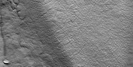
 This HiRISE image shows layers running roughly up and down, along with faint polygonal fracturing. Polygonal fractures are mostly rectangular.
 -
 South Pole layers, as seen by THEMIS
 -
 Layers, as seen by HiRISE under HiWish program
 -
 Layers, as seen by HiRISE under HiWish program
 -
 Layers, as seen by HiRISE under HiWish program


Other features
-
 "Inca City" as seen by HiRISE. Light patches are frost deposits.
 -
 Angustus Labyrinthus, as seen by THEMIS
 -
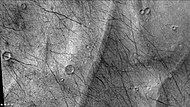
 Ridge network, as seen by HiRISE under HiWish program
 -
Layers, as seen by HiRISE under HiWish program
-
 Low center polygons, as seen by HiRISE under HiWish program. These features are common in ice-rich ground.


Other Mars quadrangles

Interactive Mars map

See also
- Climate of Mars
- Dust Devil Tracks
- HiRISE
- Impact crater
- List of quadrangles on Mars
- Martian polar ice caps
- Swiss cheese features
- Geyser (Mars)
- Water on Mars
- Martian Gullies
References
- ISBN 978-0-8165-1257-7.
- ^ Patrick Moore and Robin Rees, ed. Patrick Moore's Data Book of Astronomy (Cambridge University Press, 2011), p. 130.
- ^ NASA.gov
- ^ "NASA Reveals Probable Cause of Mars Polar Lander and Deep Space-2 Mission Failures. | SpaceRef - Your Space Reference". 28 March 2000.
- Bibcode:1991LPI....22..683K.
- ISBN 978-0-521-87201-0.
- ^ Hartmann, W. 2003. A Traveler's Guide to Mars. Workman Publishing. NY NY.
- ^ a b Malin, M., Edgett, K. 2000. Evidence for recent groundwater seepage and surface runoff on Mars. Science 288, 2330–2335.
- ^ Malin, M., K. Edgett, L. Posiolova, S. McColley, E. Dobrea. 2006. Present-day impact cratering rate and contemporary gully activity on Mars. Science 314, 1573_1577.
- ^ Kolb, et al. 2010. Investigating gully flow emplacement mechanisms using apex slopes. Icarus 2008, 132-142.
- ^ McEwen, A. et al. 2007. A closer look at water-related geological activity on Mars. Science 317, 1706-1708.
- ^ Pelletier, J., et al. 2008. Recent bright gully deposits on Mars wet or dry flow? Geology 36, 211-214.
- ^ NASA/Jet Propulsion Laboratory. "NASA orbiter finds new gully channel on Mars." ScienceDaily. ScienceDaily, 22 March 2014. www.sciencedaily.com/releases/2014/03/140322094409.htm
- ^ NASA.gov
- ^ "HiRISE | Activity in Martian Gullies (ESP_032078_1420)".
- ^ "Gullies on Mars Carved by Dry Ice, Not Water". Space.com. 16 July 2014.
- ^ NASA/Goddard Space Flight Center (March 21, 2016). "New gravity map gives best view yet inside Mars". ScienceDaily. Retrieved 15 August 2021.
- .
- ^ "Mars (Probably) has a lake of liquid water". 25 July 2018.
- ^ a b R. Orosei et al. Radar evidence of subglacial liquid water on Mars. Science. Published online July 25, 2018. doi:10.1126/science.aar7268.
- ^ "How Gas Carves Channels on Mars - SpaceRef". 28 January 2017.
- ^ a b "Gas jets spawn dark 'spiders' and spots on Mars icecap | Mars Odyssey Mission THEMIS".
- ^ NASA.gov
- ^ "Growth of a Martian Trough Network - SpaceRef". 20 December 2016.
- ^ Benson, M. 2012. Planetfall: New Solar System Visions
- ^ "Spiders Invade Mars - Astrobiology Magazine". Archived from the original on 2016-08-23. Retrieved 2015-02-16.
{{cite web}}: CS1 maint: unfit URL (link) - ^ Kieffer H, Christensen P, Titus T. 2006 Aug 17. CO2 jets formed by sublimation beneath translucent slab ice in Mars' seasonal south polar ice cap. Nature: 442(7104):793-6.
- ^ Portyankina, G., et al. 2017. Present-day erosion of Martian polar terrain by the seasonal CO2 jets. Icarus: 282, 93-103. >
- ^ NASA.gov
- ^ Portyankina, G., et al. 2019. How Martian araneiforms get their shapes: morphological analysis and diffusion-limited aggregation model for polar surface erosion Icarus. https://doi.org/10.1016/j.icarus.2019.02.032
- ^ NASA.gov
- ^ SPRING DEFROSTING OF MARTIAN POLAR REGIONS: MARS GLOBAL SURVEYOR MOC AND TES MONITORING OF THE RICHARDSON CRATER DUNE FIELD, 1999–2000. K. S. Edgett, K. D. Supulver, and M. C. Malin, Malin Space Science Systems, P.O. Box 910148, San Diego, CA 92191-0148, USA.
- ^ K.-Michael Aye, K., et al. PROBING THE MARTIAN SOUTH POLAR WINDS BY MAPPING CO2 JET DEPOSITS. 49th Lunar and Planetary Science Conference 2018 (LPI Contrib. No. 2083). 2841.pdf
- ^ "HiRISE | (PSP_00481_2410)".
- ^ NASA.gov
- ^ "Mars Exploration: Features". Archived from the original on 2011-10-28. Retrieved 2012-01-19.
- ^ Reiss, D. et al. 2011. Multitemporal observations of identical active dust devils on Mars with High Resolution Stereo Camera (HRSC) and Mars Orbiter Camera (MOC). Icarus. 215:358-369.
- ^ Allen, C. 1979. Volcano-ice interactions on Mars. J. Geophys. Res.: Solid Earth (1978–2012), 84 (B14), 8048-8059.
- ^ Howard, 1981
- ^ Kargel, J., R. Strom. 1992. Ancient glaciation on mars. Geology, 20 (1), 3-7.
- ^ a b Head, J, S. Pratt. 2001. Extensive Hesperian-aged south polar ice sheet on Mars: Evidence for massive melting and retreat, and lateral flow and pending of meltwater. J. Geophys. Res.-Planet, 106 (E6), 12275-12299.
- ^ List of U.S. states and territories by area
- ^ Scanlon, K., et al. 2018. Icarus: 299, 339-363.
- ^ Fastook, J., et al. 2012. Early Mars climate near the Noachian-Hesperian boundary: Independent evidence for cold conditions from basal melting of the south polar ice sheet (Dorsa Argentea Formation) and implications for valley network formation Icarus: 219,. 25-40.
- ^ Wordsworth, R. et al. 2013. Global modelling of the early martian climate under a denser CO2 atmosphere: Water cycle and ice evolution Icarus, 222 (1), 1-19
- ^ Forget, F. et al. 2013. 3D modelling of the early martian climate under a denser CO2 atmosphere: Temperatures and CO2 ice clouds Icarus, 222 (1), 81-99
- ^ Mischna, M, et al. 2013. Effects of obliquity and water vapor/trace gas greenhouses in the early martian climate J. Geophys. Res.-Planet, 118 (3), 560-576
- ^ Urata, R. O. Toon. 2013. Simulations of the Martian hydrologic cycle with a general circulation model: Implications for the ancient martian climate Icarus, 226 (1), 229-250
- ^ Wordsworth, R. 2016. The Climate of Early Mars Annu. Rev. Earth Planet. Sci. 44, 381-408.
- ^ Carr, M., J. Head. 2015. Martian surface/near-surface water inventory: Sources, sinks, and changes with time Geophys. Res. Lett., 42, pp. 1-7 10.1002/2014GL062464.
- ^ Kress, A., J. Head. 2015. Late Noachian and early Hesperian ridge systems in the south circumpolar Dorsa Argentea Formation, Mars: Evidence for two stages of melting of an extensive late Noachian ice sheet. Planetary and Space Science: 109-110, 1-20
- ^ Plaut, J., Ivanov, A., Safaeinili, A., Milkovich, S., Picardi, G., Seu, R., Phillips, R. 2007a. Radar sounding of subsurface layers in the South Polar plains of Mars: correlation with the Dorsa Argentea formation. Lunar Planet. Sci. XXXVIII (abstract 2144).
- ^ Head, J., Marchant, D. 2006. Regional polar glaciation in the hesperian period of the history of Mars. The South Circumpolar Dorsa Argentea Formation as an Ancient Ice Sheet Remnant. Fourth Mars Polar Science Conference. Davos, Switzerland.
- ^ Head, J., Marchant, D., Forget, F. 2007. Regional polar glaciation in the hesperian period of the history of Mars: the south circumpolar Dorsa Argentea formation as an ancient ice sheet remnant. Seventh International Conference on Mars. Pasadena, CA (abstract 3115).
- ^ Scanlon, K., et al. 2018. The Dorsa Argentea Formation and the Noachian-Hesperian climate transition. Icarus: 299, 339-363.
- ^ "Mars: The planet that lost an ocean's worth of water".
- ^ . Villanueva, L., Mumma, R. Novak, H. Käufl, P. Hartogh, T. Encrenaz, A. Tokunaga, A. Khayat, M. Smith. Strong water isotopic anomalies in the martian atmosphere: Probing current and ancient reservoirs. Science, 2015 DOI: 10.1126/science.aaa3630
- ^ http://www.geo.brown.edu/research/Milliken/GEOL2920C_files/Week04_Summary_Jawin.pdf [bare URL PDF]
- ^ Malin, M. C., & Edgett, K. S. (2000). Sedimentary Rocks of Early Mars. Science, 290(5498), 1927–1937
- ^ NASA.gov
- ^ NASA.gov
- ^ "HiRISE | High Resolution Imaging Science Experiment". Hirise.lpl.arizona.edu?psp_008437_1750. Retrieved 2012-08-04.
- ^ Grotzinger, J. and R. Milliken (eds.). 2012. Sedimentary Geology of Mars. SEPM.
- ^ Grotzinger, J.P. and R.E. Milliken (2012). The sedimentary rock record of Mars: Distribution, origins, and global stratigraphy, SEPM Special Publication, 102, 1-48.
- ^ Thomas, P., M. Malin, P. James, B. Cantor, R. Williams, P. Gierasch South polar residual cap of Mars: features, stratigraphy, and changes Icarus, 174 (2 SPEC. ISS.). 2005. pp. 535–559. http://doi.org/10.1016/j.icarus.2004.07.028
- ^ Thomas, P., P. James, W. Calvin, R. Haberle, M. Malin. 2009. Residual south polar cap of Mars: stratigraphy, history, and implications of recent changes Icarus: 203, 352–375 http://doi.org/10.1016/j.icarus.2009.05.014
- ^ Thomas, P., W.Calvin, P. Gierasch, R. Haberle, P. James, S. Sholes. 2013. Time scales of erosion and deposition recorded in the residual south polar cap of mars Icarus: 225: 923–932 http://doi.org/10.1016/j.icarus.2012.08.038
- ^ Thomas, P., W. Calvin, B. Cantor, R. Haberle, P. James, S. Lee. 2016. Mass balance of Mars’ residual south polar cap from CTX images and other data Icarus: 268, 118–130 http://doi.org/10.1016/j.icarus.2015.12.038
- ^ Buhler, Peter, Andrew Ingersoll, Bethany Ehlmann, Caleb Fassett, James Head. 2017. How the martian residual south polar cap develops quasi-circular and heart-shaped pits, troughs, and moats. Icarus: 286, 69-9.
- ISBN 0-312-24551-3.
- ^ "Online Atlas of Mars". Ralphaeschliman.com. Retrieved December 16, 2012.
- ^ "PIA03467: The MGS MOC Wide Angle Map of Mars". Photojournal. NASA / Jet Propulsion Laboratory. February 16, 2002. Retrieved December 16, 2012.