
Aeolis quadrangle
| Coordinates | 15°00′S 202°30′W / 15°S 202.5°W |
|---|
The Aeolis quadrangle is one of a series of 30 quadrangle maps of Mars used by the United States Geological Survey (USGS) Astrogeology Research Program. The Aeolis quadrangle is also referred to as MC-23 (Mars Chart-23).[1] The Aeolis quadrangle covers 180° to 225° W and 0° to 30° south on Mars, and contains parts of the regions Elysium Planitia and Terra Cimmeria. A small part of the Medusae Fossae Formation lies in this quadrangle.
The name refers to the name of a floating western island of Aeolus, the ruler of the winds. In Homer's account, Odysseus received the west wind Zephyr here and kept it in bags, but the wind got out.[2] [3]
It is famous as the site of two spacecraft landings: the
A large, ancient river valley, called
Gale Crater, in the northwestern part of the Aeolis quadrangle, is of special interest to geologists because it contains a 2–4 km (1.2–2.5 mi) high mound of layered sedimentary rocks, named
Some regions in the Aeolis quadrangle show inverted relief.[11] In these locations, a stream bed may be a raised feature, instead of a valley. The inverted former stream channels may be caused by the deposition of large rocks or due to cementation. In either case erosion would erode the surrounding land but leave the old channel as a raised ridge because the ridge will be more resistant to erosion
Yardangs are another feature found in this quadrangle. They are generally visible as a series of parallel linear ridges, caused by the direction of the prevailing wind.
Spirit rover discoveries
The rocks on the plains of Gusev are a type of basalt. They contain the minerals olivine, pyroxene, plagioclase, and magnetite, and they look like volcanic basalt as they are fine-grained with irregular holes (geologists would say they have vesicles and vugs).[12][13] Much of the soil on the plains came from the breakdown of the local rocks. Fairly high levels of


There are a variety of rocks in the Columbia Hills, some of which have been altered by water, but not by very much water.
The dust in Gusev Crater is the same as dust all around the planet. All the dust was found to be magnetic. Moreover, Spirit found the magnetism was caused by the mineral magnetite, especially magnetite that contained the element titanium. One magnet was able to completely divert all dust hence all Martian dust is thought to be magnetic.[16] The spectra of the dust was similar to spectra of bright, low thermal inertia regions like Tharsis and Arabia that have been detected by orbiting satellites. A thin layer of dust, maybe less than one millimeter thick, covers all surfaces. Something in it contains a small amount of chemically bound water.[17][18]
Plains

true-color view of Adirondack, taken by Spirit's pancam. grind (Spirit's rock grinding tool)Right: Digital camera image (from Spirit's Pancam) of Adirondack after a RAT | |
| Feature type | Rock |
|---|---|
Observations of rocks on the plains show they contain the minerals pyroxene, olivine, plagioclase, and magnetite. These rocks can be classified in different ways. The amounts and types of minerals make the rocks primitive basalts—also called picritic basalts. The rocks are similar to ancient terrestrial rocks called basaltic
The first rock that Spirit studied was Adirondack. It turned out to be typical of the other rocks on the plains.
-
 First color picture from Gusev crater. Rocks were found to be basalt. Everything was covered with a fine dust that Spirit determined was magnetic because of the mineral magnetite.
 -
 Cross-sectional drawing of a typical rock from the plains of Gusev crater. Most rocks contain a coating of dust and one or more harder coatings. Veins of water-deposited veins are visible, along with crystals of olivine. Veins may contain bromine salts.


Columbia Hills
Scientists found a variety of rock types in the Columbia Hills, and they placed them into six different categories. The six are: Clovis, Wishbone, Peace, Watchtower, Backstay, and Independence. They are named after a prominent rock in each group. Their chemical compositions, as measured by APXS, are significantly different from each other.[19] Most importantly, all of the rocks in Columbia Hills show various degrees of alteration due to aqueous fluids.[20] They are enriched in the elements phosphorus, sulfur, chlorine, and bromine—all of which can be carried around in water solutions. The Columbia Hills' rocks contain basaltic glass, along with varying amounts of olivine and sulfates.[21][22] The olivine abundance varies inversely with the amount of sulfates. This is exactly what is expected because water destroys olivine but helps to produce sulfates.
Acid fog is believed to have changed some of the Watchtower rocks. This was in a 200 meter long section of Cumberland Ridge and the Husband Hill summit. Certain places became less crystalline and more amorphous. Acidic water vapor from volcanoes dissolved some minerals forming a gel. When water evaporated, a cement formed and produced small bumps. This type of process has been observed in the lab when basalt rocks are exposed to sulfuric and hydrochloric acids.[23][24][25]
The Clovis group is especially interesting because the
Towards the middle of the six-year mission (a mission that was supposed to last only 90 days), large amounts of pure
After Spirit stopped working scientists studied old data from the Miniature Thermal Emission Spectrometer, or Mini-TES and confirmed the presence of large amounts of carbonate-rich rocks, which means that regions of the planet may have once harbored water. The carbonates were discovered in an outcrop of rocks called "Comanche".[30][31]
In summary, Spirit found evidence of slight weathering on the plains of Gusev, but no evidence that a lake was there. However, in the Columbia Hills there was clear evidence for a moderate amount of aqueous weathering. The evidence included sulfates and the minerals goethite and carbonates which only form in the presence of water. It is believed that Gusev crater may have held a lake long ago, but it has since been covered by igneous materials. All the dust contains a magnetic component which was identified as magnetite with some titanium. Furthermore, the thin coating of dust that covers everything on Mars is the same in all parts of Mars.
Ma'adim Vallis

Recent studies lead scientists to believe that the water that formed Ma'adim Vallis originated in a complex of lakes.
There is enormous evidence that water once flowed in river valleys on Mars. Images of curved channels have been seen in images from Mars spacecraft dating back to the early 1970s with the Mariner 9 orbiter.[37][38][39][40]
Vallis (plural valles) is the
Gale Crater
-
 Gale crater - surface materials (false colors; THEMIS; 2001 Mars Odyssey)
 -
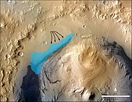
 Aeolis Mons rising from the center. The noted Curiosity rover landing area is near Peace Vallis in Aeolis Palus.
 -
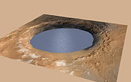 Ancient Lake fills Gale Crater on Mars (simulated view).
 -
-
 Peace Vallis and alluvial fan near the Curiosity rover landing ellipse and site (noted by +)


-
 Mount Sharp- a planned area of study.
 -
 Curiosity rover landing site - "Quad Map" includes "Yellowknife" Quad 51 of Aeolis Palus in Gale Crater.
 -
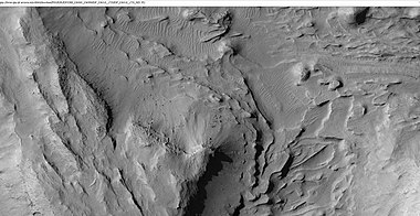
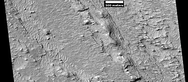
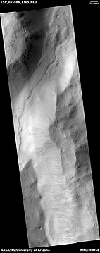
 Gale Crater Grand Canyon, as seen by HiRISE. Scale bar is 500 meters long.
 -
 Gale Crater sediment layers may have formed by lake or windblown particle deposition.
 -
 Gale Crater rim about 18 km (11 mi) North of the Curiosity rover on August 9, 2012
 -
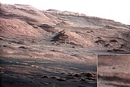
 Aeolis Mons and Aeolis Palusin Gale Crater as viewed by the Curiosity rover on August 6, 2012
 -
 Aeolis Mons may have formed from the erosion of sediment layersthat once filled Gale Crater.
 -
 Aeolis Mons as viewed from the Curiosity rover (August 9, 2012) (white balanced image)
 -
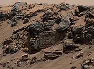
 Layers at the base of Aeolis Mons - dark rock in inset is same size as the Curiosity rover (white balanced image).
 -
 MAHLI, September 9, 2012).
 -
 First-Year and First-Mile Traverse Map of the Curiosity rover on Mars (August 1, 2013) (3-D)


-
 Slip Face on Downwind Side of 'Namib' Sand Dune on Mars, as seen by Curiosity. Dune stands about 13 feet (4.0 meters) high. Picture taken with Navcam.
 -
 This evenly layered rock photographed by the Mast Camera (Mastcam) on NASA's Curiosity Mars rover shows a pattern typical of a lake-floor sedimentary deposit not far from where flowing water entered a lake.
 -
 View from the "Kimberley" formation on Mars taken by NASA's Curiosity rover
 -
 View from Mastcam on Curiosity showing sloping buttes and layered outcrops on lower Mount Sharp


Other craters
Impact craters generally have a rim with ejecta around them, in contrast volcanic craters usually do not have a rim or ejecta deposits. As craters get larger (greater than 10 km in diameter) they usually have a central peak.[61] The peak is caused by a rebound of the crater floor following the impact.[41] Sometimes craters will display layers. Since the collision that produces a crater is like a powerful explosion, rocks from deep underground are tossed onto the surface. Hence, craters can show us what lies deep under the surface.
-
 Boeddicker CraterFloor, as seen by HiRISE
 -
 Central uplift of an Unnamed crater on the floor ofMolesworth Crater, as seen by HiRISE. Dark sand dunes are on left side of image. The scale bar is 500 meters long.
 -
 Reuyl CraterCentral Peak, as seen by HiRISE
 -
 Galdakao Crater, as seen by HiRISE. Click on image to see dark slope streaks.
 -
 Layers in crater wall, as seen by HiRISE under HiWish program. Area in box is enlarged in the next image.
 -
 Enlargement from previous image, showing many thin layers. Note that the layers do not seem to be formed from rocks. They may be all that is left of a deposit that once filled the crater. Image was taken with HiRISE, under HiWish program.
 -
 Gullies on wall of impact crater, as seen by HiRISE under HiWish program. Curved ridges on the floor are remains of old glaciers.
 -
 Graff Crater (Martian Crater), as seen by CTX camera (on Mars Reconnaissance Orbiter)


Mars Science Laboratory discoveries
The aim of the
On August 6, 2012, the Mars Science Laboratory landed on
On September 27, 2012,

On October 17, 2012, at
On December 3, 2012, NASA reported that Curiosity performed its first extensive

On March 18, 2013, NASA reported evidence of mineral hydration, likely hydrated calcium sulfate, in several rock samples including the broken fragments of "Tintina" rock and "Sutton Inlier" rock as well as in veins and nodules in other rocks like "Knorr" rock and "Wernicke" rock.[70][71][72] Analysis using the rover's DAN instrument provided evidence of subsurface water, amounting to as much as 4% water content, down to a depth of 60 cm (2.0 ft), in the rover's traverse from the Bradbury Landing site to the Yellowknife Bay area in the Glenelg terrain.[70]
In March 2013, NASA reported Curiosity found evidence that
In the journal Science from September 2013, researchers described a different type of rock called
On December 9, 2013, NASA researchers described, in a series of six articles in the journal
Using SAM's
The absorbed dose and dose equivalent from galactic cosmic rays and
The samples examined were probably once mud that for millions to tens of millions of years could have hosted living organisms. This wet environment had neutral pH, low salinity, and variable redox states of both iron and sulfur species.[81][90][91][92] These types of iron and sulfur could have been used by living organisms.[93] Carbon, hydrogen, oxygen, sulfur, nitrogen, and phosphorus were measured directly as key biogenic elements, and by inference, phosphorus is assumed to have been available.[84][86] The two samples, John Klein and Cumberland, contain basaltic minerals, Ca-sulfates, Fe oxide/hydroxides, Fe-sulfides, amorphous material, and trioctahedral smectites (a type of clay). Basaltic minerals in the mudstone are similar to those in nearby aeolian deposits. However, the mudstone has far less Fe-forsterite plus magnetite, so Fe-forsterite (type of olivine) was probably altered to form smectite (a type of clay) and magnetite.[94] A Late Noachian/Early Hesperian or younger age indicates that clay mineral formation on Mars extended beyond Noachian time; therefore, in this location neutral pH lasted longer than previously thought.[90]
In a press conference on December 8, 2014, Mars scientists discussed observations by Curiosity rover that show Mars' Mount Sharp was built by sediments deposited in a large lake bed over tens of millions of years. This finding suggests the climate of ancient Mars could have produced long-lasting lakes at many places on the Planet. Rock layers indicate that a huge lake was filled and evaporated many times. The evidence was many deltas that were stacked upon each other.[95][96][97][98][99]
Also in December 2014, it was announced that Curiosity had detected sharp increases in methane four times out of twelve during a 20-month period with the Tunable Laser Spectrometer (TLS) of the Sample Analysis at Mars instrument (SAM). Methane levels were ten times the usual amount. Due to the temporary nature of the methane spike, researchers believe the source is localized. The source may be biological or non-biological.[100][101][102]
On December 16, 2014, a team of researchers described how they have concluded that
On March 24, 2015, a paper was released describing the discovery of nitrates in three samples analyzed by Curiosity. The nitrates are believed to have been created from diatomic nitrogen in the atmosphere during meteorite impacts.[105][106] Nitrogen is needed for all forms of life because it is used in the building blocks of larger molecules like DNA and RNA. Nitrates contain nitrogen in a form that can be used by living organisms; nitrogen in the air can not be used by organisms. This discovery of nitrates adds to the evidence that Mars once had life.[107][108]
The Jet Propulsion Laboratory (JPL) announced in April 2015 the discovery of a network of two-tone mineral veins at an area called "Garden City" on lower Mount Sharp. The veins stand about 2.5 inches above the surface and are composed of two different minerals formed from at least two different fluid flows.[109] In Pahrump Hills, an area about 39 feet lower, the minerals clay, hematite, jarosite, quartz, and cristobalite were found.[110][111]
Measurements made by Curiosity allowed researchers to determine that Mars has liquid water at times. Because the humidity goes to 100% at night, salts, like
French and U.S. scientists found a type of granite by studying images and chemical results of 22 rock fragments. The composition of the rocks was determined with the ChemCam instrument. These pale rocks are rich in feldspar and may contain some quartz. The rocks are similar to Earth's granitic continental crust. They are like rocks called TTG (Tonalite-Trondhjemite-Granodiorite). On the Earth, TTG was common in the terrestrial continental crust in the Archean era (more than 2.5 billion years ago). By landing in Gale crater, Curiosity was able to sample a variety of rocks because the crater dug deep into the crust, thus exposing old rocks, some of which may be about 3.6 billion years old. For many years, Mars was thought to be composed of the dark, igneous rock basalt, so this is a significant discovery.[116][117][118]
On October 8, 2015, a large team of scientists confirmed the existence of long-lasting lakes in Gale Crater. The conclusion of Gale having lakes was based on evidence of old streams with coarser gravel in addition to places where streams appear to have emptied out into bodies of standing water. If lakes were once present, Curiosity would start seeing water-deposited, fine-grained rocks closer to Mount Sharp. That is exactly what happened.
Finely laminated mudstones were discovered by Curiosity; this lamination represents the settling of plumes of fine sediment through a standing body of water. Sediment deposited in a lake formed the lower portion of Mount Sharp, the mountain in Gale crater.[119][120][121]
At a press conference in San Francisco at the
As of the beginning of 2016, Curiosity had discovered seven hydrous minerals. The minerals are actinolite, montmorillonite, saponite, jarosite, halloysite, szomolnokite and magnesite. In some places the total concentration of all hydrous minerals was 40 vol%. Hydrous minerals help us understand the early water environment and possible biology on Mars.[124]
By using Curiosity's laser-firing device (ChemCam), scientists found manganese oxides in mineral veins in the "Kimberley" region of Gale Crater. These minerals need lots of water and oxidizing conditions to form; hence this discovery points to a water-rich, oxygen-rich past.[125][126][127]
A study of the kinds of minerals in veins examined with Curiosity found that evaporating lakes were present in the past in Gale crater. The Sheepbed Member mudstones of Yellowknife Bay (YKB) were examined in this research.[128][129]
Frost probably has formed in three locations in the first 1000 sols of the mission of the Curiosity exploration according to research published in Icarus in 2016.[130] This frost can cause weathering. Frost formation can explain the widespread detection of hydrated materials from orbit with the OMEGA instrument; it also can explain the hydrated component measured by Curiosity in Martian soil.[131][132][133]
Researchers in December 2016 announced the discovery of the element boron on Mars by Curiosity in mineral veins. For boron to be present there must have been a temperature between 0–60 degrees Celsius and a neutral-to-alkaline pH." The temperature, pH, and dissolved minerals of the groundwater support a habitable environment.[134] Moreover, boron has been suggested to be necessary for life to form. Its presence stabilizes the sugar ribose which is an ingredient in RNA.[135][136][137] Details of the discovery of Boron on Mars were given in a paper written by a large number of researchers and published in Geophysical Research Letters.[138][139][140]
Researchers have concluded that Gale Crater has experienced many episodes of groundwater with changes in the groundwater chemistry. These chemical changes would support life.[141][142][143][144][145][146]

In January 2017, JPL scientists announced the discovery of mud cracks on Mars. This find adds more evidence that Gale Crater was wet in the past.[147][148][149][150]
Studies of the wind around the Curiosity rover over a period of 3 billion years has shown that the Mount Sharp, the mound inside Gale Crater was created when winds removed material over billions of years and left material in the middle that is Mount Sharp. The researchers calculated that about 15,000 cubic miles (64,000 cubic kilometers) of material was removed from the crater. Curiosity has seen dust devils in action in the distance. Also, changes were visible as a dust devil passed close to the rover. Ripples in the sand below Curiosity were observed to move about one inch (2.5 cm) in just one day.[151][152]
CheMin found feldspar, mafic igneous minerals, iron oxides, crystalline
An analysis of a large amount of data from ChemCam and APXS showed that most of the material encountered by Curiosity consists of just two major igneous rock types and traces of three others. One chief type is classified as a subalkaline, Mg-rich basalt (similar to MER Spirit basalt) and the other was a more evolved, higher Si, Al, lower Mg basalt.[155]

A large group of researchers discovered halos around fractures that they water existed in the ground long after water disappeared from Gale crater. Groundwater, carrying dissolved silica, moved in fractures and deposited silica there. This silica enrichment went across young and old rocks.[156][157]
Research of chemicals in layers in Gale Crater, published in 2017, suggest that the lake in Gale Crater had a neutral pH for much of the time. The mudstone in the Murray formation at the base of
Research presented in a June 2018 press conference described the detection of more organic molecules in a drill sample analyzed by Curiosity.[160][161] Some of the organic molecules found were thiophenes, benzene, toluene, and small carbon chains, such as propane or butane.[162] At least 50 nanomoles of organic carbon are still in the sample, but were not specifically determined. The remaining organic material probably exists as macromolecules organic sulfur molecules. Organic matter was from lacustrine mudstones at the base of the ~3.5-billion-year-old Murray formation at Pahrump Hills, by the Sample Analysis at Mars instrument suite.[163]
With two full Martian years (five Earth years) of measurements, scientists found that the annual average concentration of methane in Mars' atmosphere is 0.41 ppb. However, methane levels rise and fall with the seasons, going from 0.24 ppb in winter to 0.65 ppb in summer. The researchers also saw relatively large methane spikes, up to about 7 ppb, at random intervals.[160][164] The existence of methane in the Martian atmosphere is exciting because on Earth, most methane is produced by living organisms. Methane on Mars does not prove that life exists there, but it is consistent with life. Ultraviolet radiation from the sun destroys methane does not last long; consequently, something must have been creating or releasing it.[164]
Using date gathered with Mastcam, a team of researchers have found what they believe to be iron meteorites. These meteorites stand out in multispectral observations as not possessing the usual ferrous or ferric absorption features as the surrounding surface.[165]
Emily Lakdaealla wrote a detailed 2018 book about the Curiosity rover's instruments and history. She listed the minerals that Curiosity's CheMin has discovered. CheMin has discovered olivine, pyroxene, feldspar, quartz, magnetite, iron sulfides (pyrite and pyrrhotite), akaganeite, jarosite, and calcium sulfates (gypsum, anhydrite, basanite) [166]
Research presented in 2018 at the Geological Society of America Annual Meeting in Indianapolis, Indiana described evidence for huge floods in Gale Crater. One rock unit examined by Curiosity contains the rock conglomerate with particles up to 20 centimeters across. To create such a type of rock water must have been 10 to 20 meters in depth. Between two million years to 12,000 years ago, Earth experienced these type of floods.[167][168][169]
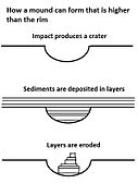
Using various gravity measurements, a team of scientists concluded that Mount Sharp may have formed right where it is, as it is. The authors stated, "Mount Sharp formed largely in its current form as a free-standing mound within Gale."[170] One idea was that it was part of material that covered a wide region and then eroded, leaving Mount Sharp. However, if that were the case, the layers on the bottom would be fairly dense. This gravity data show that the bottom layers are quite porous. Had they been under many layers of rock they would be compressed and be more dense. Intensity of the gravity was obtained by using data from Curiosity's accelerometers.[171][172][173]
Researched published in Nature Geoscience in October 2019 described how Gale crater underwent many wet and dry cycles as its lake waters disappeared.[174] Sulfate salts from evaporated water showed that pools of salty water once existed in Gale Crater. These ponds could have supported organisms. Basalts could have produced the calcium and magnesium sulfates that were found. Because of its low solubility, calcium sulfate is deposited early on as a lake dries up. However, the discovery of magnesium sulfate salts means that the lake must have almost totally evaporated. The remaining pools of water would have been very salty—such lakes on Earth contain organisms that are salt tolerant or "halotolerant". These minerals were found along the edges of what were lakes in the younger parts of Gale Crater.[175] When Curiosity was exploring deeper in the crater, clays found there showed that a lake existed for a long time, these new findings of sulfates the lake dried up and then get wetter over and over.
Sulfate salts have been detected in other places in Gale as white veins caused by groundwater moving through cracks in the rocks.[176]
Curiosity has found oxygen going into the air in Gale Crater. Measurements over three Martian years (almost six Earth years) by an instrument in the Sample Analysis at Mars (SAM) portable chemistry lab revealed that the level of oxygen went up throughout spring and summer by as much as 30%, and then dropped back to normal levels by fall. Each spring this occurred. These oxygen seasonal variations suggest some unknown process in the atmosphere or the surface is occurring.[177][178][179]

Evidence of life on Mars was published on January 19, 2022. Rover's Tunable Laser Spectrometer (TLS) determined the abundance of carbon
Inverted relief
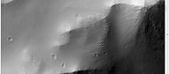
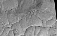
Some places on Mars show inverted relief. In these locations, a stream bed may be a raised feature, instead of a valley. The inverted former stream channels may be caused by the deposition of large rocks or due to cementation. In either case erosion would erode the surrounding land but leave the old channel as a raised ridge because the ridge will be more resistant to erosion.[181] An image below, taken with HiRISE shows sinuous ridges that may be old channels that have become inverted.[182]
-
 Meandering Ridges that are probably inverted stream channels. Image taken with HiRISE.
 -
 CTX image of craters with black box showing location of next image
 -
 Image from previous photo of a curved ridge that may be an old stream that has become inverted. Image taken with HiRISE under the HiWish program.
 -
 Sinuous Ridges within a branching fan in lower member of Medusae Fossae Formation, as seen by HiRISE
 -
 Inverted channels in Aleolis Planum NASA comments on these thusly: "These likely represent ancient, meandering river channels that flowed across the surface and buried themselves over time. The channels have subsequently been exposed to the surface by the wind, forming the cross-cutting ridges."
 -
 Close view of inverted channels. Note that some are flat on top.


Yardangs
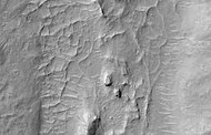
Yardangs are common on Mars.[183] They are generally visible as a series of parallel linear ridges. Their parallel nature is thought to be caused by the direction of the prevailing wind. Two HiRISE images below show a good view of yardangs in the Aeolis quadrangle.[182] Yardangs are common in the Medusae Fossae Formation on Mars.
-
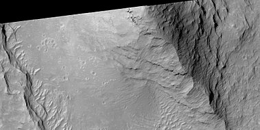
 Stream channels in inverted relief and yardangs, as seen by HiRISE
 -
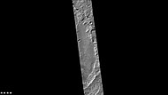
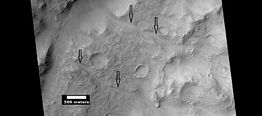
 Aeolis Mensae Yardangs, as seen by HiRISE. Scale bar is 500 meters long. Click on image for better view of yardangs.
 -
 Apollinaris Patera, as seen by HiRISE
 -
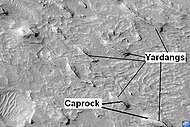 Yardangs in Medusae Fossae Formation with caprock labeled, as seen by HiRISE
 -
 Yardangs, as seen by HiRISE


Fretted terrain
Parts of the Aeolis quadrangle contain
Layered terrain
Researchers, writing in Icarus, have described layered units in the Aeolis quadrangle at Aeolis Dorsa. A deposit that contains yardang was formed after several other deposits. The yardangs contain a layered deposit called "rhythmite" which was thought to be formed with regular changes in the climate. Because the layers appear harden, a damp or wet environment probably existed at the time. The authors correlate these layered deposits to the upper layers of Gale crater's mound (Mt. Sharp).[186]
Many places on Mars show rocks arranged in layers. Sometimes the layers are of different colors. Light-toned rocks on Mars have been associated with hydrated minerals like
Scientists were excited about finding hydrated minerals such as sulfates and clays on Mars because they are usually formed in the presence of water.[190] Places that contain clays and/or other hydrated minerals would be good places to look for evidence of life.[191]
Rock can form layers in a variety of ways. Volcanoes, wind, or water can produce layers.
-
 Layers in lower member of Medusae Fossae Formation, as seen by HiRISE
 -
 Buttes and layers in Aeolis, as seen by Mars Global Surveyor
 -
 Layers, as seen by HiRISE
 -
 Layers along crater rim in Terra Sirenum, as seen by HiRIS under the HiWish program
 -
 Layered terrain, as seen by HiRISE under HiWish program. Location is East of Gale Crater in the Aeolis quadrangle.
 -
 Layers and mounds in Medusae Fossae Formation, as seen by HiRISE under HiWish program. Location is East of Gale Crater in the Aeolis quadrangle.
 -
 Layers and a field of small mounds Medusae Fossae Formation, as seen by HiRISE under HiWish program. Location is east of Gale Crater in the Aeolis quadrangle.
 -
 Mound showing layers at the base, as seen by HiRISE under HiWish program. Location is east of Gale Crater in the Aeolis quadrangle.
 -
 Layered structure, as seen by HiRISE under HiWish program
 -
 Layered features northeast of Gale Crater, as seen by HiRISE under HiWish program. Layers may be similar to the many layers that are being examined by the Curiosity rover.
 -
 Wide view of layered terrain, as seen by HiRISE under HiWish program. Location is northeast of Gale Crater.
 -
 Close view of mound with layers, as seen by HiRISE under HiWish program. Note: this is an enlargement from the previous image.
 -
 Close view of mound with layers, as seen by HiRISE under HiWish program. Note: this is an enlargement from a previous image.
 -
 Wide view of layered terrain, as seen by HiRISE under HiWish program. Note: parts of this image are enlarged in the next three images.
 -
 Close view of layers in a mound, from previous image, as seen by HiRISE under HiWish program
 -
 Close view of layers in a mound, from a previous image, as seen by HiRISE under HiWish program
 -
 Close view of layers in a mound, from a previous image, as seen by HiRISE under HiWish program


-
 Wide view of layered buttes and small mesas, as seen by HiRISE under HiWish program. Somedark slope streaksare visible.
 -
 Layered mesa and mounds with dark slope streaks, as seen by HiRISE under HiWish program
 -
 Close view of layered small mesa with dark slope streak, as seen by HiRISE under HiWish program. Box shows the size of a football field.
 -
 Close view of dark slope streak with strange breaks, as seen by HiRISE under HiWish program
 -
 Very close view of individual blocks breaking off layer in a butte, as seen by HiRISE under HiWish program. Blocks have angular shapes. Box shows size of football field.
 -
 Close view of blocks from a mesa, as seen by HiRISE under HiWish program. Arrow show a cube-shaped block.


-
 Layered mesas, as seen by HiRISE under HiWish program
 -
 Layered mesas, as seen by HiRISE under HiWish program.Dark slope streaksare also visible.
 -
 Mesas, as seen by HiRISE under HiWish program. Top layer, the cap rock is breaking up into boulders.
 -
 Close view of cap rock breaking up into boulders, as seen by HiRISE under HiWish program


Linear ridge networks
Linear ridge networks are found in various places on Mars in and around craters.[194] Ridges often appear as mostly straight segments. They are hundreds of meters long, tens of meters high, and several meters wide. It is thought that impacts created fractures in the surface, these fractures later acted as channels for fluids. Fluids cemented the structures. With the passage of time, surrounding material was eroded away, thereby leaving hard ridges behind. Since the ridges occur in locations with clay, these formations could serve as a marker for clay which requires water for its formation.[195][196][197]
-
 Wide view of ridges, as seen by HiRISE under HiWish program
 -
 Color view of ridges, as seen by HiRISE under HiWish program
 -
 Ridges, as seen by HiRISE under HiWish program
 -
 Ridges, as seen by HiRISE under HiWish program
 -
 Ridges, as seen by HiRISE under HiWish program
 -
 Ridges, as seen by HiRISE under HiWish program
 -
 Ridges, as seen by HiRISE under HiWish program
 -
 Ridges, as seen by HiRISE under HiWish program
 -
 Ridges, as seen by HiRISE under HiWish program


Other features
-
 Landslide
 -
 Possible fan or delta, as seen by HiRISE under HiWish program
 -
 Channel, as seen by HiRISE under HiWish program
 -
 Channels (indicated with arrows), as seen by HiRISE under HiWish program
 -
 Channel, as seen by HiRISE under HiWish program
 -
 Tilted blocks as seen by HiRISE under HiWish program These blockls were formed horizonality, but have been tilted. Perhaps ice left the ground on one side.


Other Mars quadrangles

Interactive Mars map

See also
- Adirondack – Boulder on Mars
- Carbonates on Mars – Overview of the presence of carbonates on Mars
- Climate of Mars – Climate patterns of the planet Mars
- Composition of Mars – Branch of the geology of Mars
- Equatorial layered deposits – Surface geological deposits on Mars
- Geology of Mars – Scientific study of the surface, crust, and interior of the planet Mars
- Groundwater on Mars – Water held in permeable ground
- Impact crater – Circular depression in a solid astronomical body formed by the impact of a smaller object
- Lakes on Mars – Overview of the presence of lakes on Mars
- Scientific information from the Mars Exploration Rover mission
- Timeline of Mars Science Laboratory – Event timeline of the NASA Mars Science Laboratory mission
- Yardangs on Mars – Aeolian formation
References
- ^ Davies, M.E.; Batson, R.M.; Wu, S.S.C. "Geodesy and Cartography" in Kieffer, H.H.; Jakosky, B.M.; Snyder, C.W.; Matthews, M.S., Eds. Mars. University of Arizona Press: Tucson, 1992.
- ^ "Planetary Names".
- ^ Blunck, J. 1982. Mars and its Satellites. Exposition Press. Smithtown, N.Y.
- JPL. Archived from the originalon 2012-08-14. Retrieved 2012-08-07.
- ^ a b "Spirit rover follows up on scientific surprises". NBC News. 4 January 2005. Retrieved 16 June 2017.
- ^ a b U.S. department of the Interior U.S. Geological Survey, Topographic Map of the Eastern Region of Mars M 15M 0/270 2AT, 1991
- ^ a b c NASA Staff (27 March 2012). "'Mount Sharp' on Mars Compared to Three Big Mountains on Earth". NASA. Retrieved 31 March 2012.
- ^ a b c Agle, D. C. (28 March 2012). "'Mount Sharp' On Mars Links Geology's Past and Future". NASA. Retrieved 31 March 2012.
- ^ a b c Staff (29 March 2012). "NASA's New Mars Rover Will Explore Towering 'Mount Sharp'". Space.com. Retrieved 30 March 2012.
- ^ USGS. Retrieved 3 March 2021.
- ^ Ori, G., I. Di Pietro, F. Salese. 2015. A WATERLOGGED MARTIAN ENVIRONMENT: CHANNEL PATTERNS AND SEDIMENTARY ENVIRONMENTS OF THE ZEPHYRIA ALLUVIAL PLAIN. 46th Lunar and Planetary Science Conference (2015) 2527.pdf
- ^ a b c McSween, etal. 2004. "Basaltic Rocks Analyzed by the Spirit Rover in Gusev Crater". Science : 305. 842–845
- ^ S2CID 31102951.
- S2CID 129432577.
- S2CID 34983664.
- ^ Bertelsen, P., et al. 2004. "Magnetic Properties on the Mars Exploration Rover Spirit at Gusev Crater". Science: 305. 827–829
- ^ ISBN 978-0-521-86698-9
- ^ Gelbert, R. et al. "Chemistry of Rocks and Soils in Gusev Crater from the Alpha Particle X-ray Spectrometer". Science: 305. 829-305
- ^ Squyres, S., et al. 2006 Rocks of the Columbia Hills. J. Geophys. Res. Planets. 111
- ^ Ming,D., et al. 2006 Geochemical and mineralogical indicators for aqueous processes in the Columbia Hills of Gusev crater, Mars. J. Geophys: Res.111
- ^ a b Schroder, C., et al. (2005) European Geosciences Union, General Assembly, Geophysical Research abstr., Vol. 7, 10254, 2005
- Bibcode:2005AGUSM.P31A..04C.
- ^ "Signs of Acid Fog Found on Mars – SpaceRef". spaceref.com. 2 November 2015. Archived from the original on August 29, 2016. Retrieved 16 June 2017.
- ^ "Abstract: IN-SITU EVIDENCE FOR ALTERATION BY ACID FOG ON HUSBAND HILL, GUSEV CRATER, MARS (2015 GSA Annual Meeting in Baltimore, Maryland, USA (1–4 November 2015))". gsa.confex.com. Retrieved 16 June 2017.
- ^ COLE, Shoshanna B., et al. 2015. IN-SITU EVIDENCE FOR ALTERATION BY ACID FOG ON HUSBAND HILL, GUSEV CRATER, MARS. 2015 GSA Annual Meeting in Baltimore, Maryland, USA (1–4 November 2015) Paper No. 94-10
- ^ Klingelhofer, G., et al. (2005) Lunar Planet. Sci. XXXVI abstr. 2349
- ^ Morris,S., et al. Mossbauer mineralogy of rock, soil, and dust at Gusev crater, Mars: Spirit’s journal through weakly altered olivine basalt on the plains and pervasively altered basalt in the Columbia Hills. J. Geophys. Res.: 111
- ^ Ming,D., et al. 2006 Geochemical and mineralogical indicators for aqueous processes in the Columbia Hills of Gusev crater, Mars. J. Geophys. Res.111
- ^ "NASA - Mars Rover Spirit Unearths Surprise Evidence of Wetter Past". Nasa.gov. 2007-05-21. Retrieved 2017-06-16.
- ^ "Outcrop of long-sought rare rock on Mars found". Retrieved 16 June 2017.
- S2CID 7461676.
- ^ Cabrol, N. and E. Grin (eds.). 2010. Lakes on Mars. Elsevier. NY.
- S2CID 23390665.
- ^ "HiRISE | Chaos in Eridania Basin (ESP_037142_1430)". Uahirise.org. 2014-09-10. Retrieved 2017-06-16.
- S2CID 23390665.
- ^ "APOD: 2002 June 27 – Carving Ma'adim Vallis". antwrp.gsfc.nasa.gov. Retrieved 16 June 2017.
- ^ Baker, V. 1982. The Channels of Mars. Univ. of Tex. Press, Austin, TX
- S2CID 4321529.
- .
- .
- ^ ISBN 978-0-8165-1257-7. Retrieved 7 March 2011.
- ^ Raeburn, P. 1998. Uncovering the Secrets of the Red Planet Mars. National Geographic Society. Washington D.C.
- ^ Moore, P. et al. 1990. The Atlas of the Solar System. Mitchell Beazley Publishers NY, NY.
- .
- ^ Hanna, J. and R. Phillips. 2005. Tectonic pressurization of aquifers in the formation of Mangala and Athabasca Valles on Mars. LPSC XXXVI. Abstract 2261.
- ^ "HiRISE | Layered Outcrop in Gale Crater (PSP_008437_1750)". Hirise.lpl.arizona.edu. 2008-08-06. Retrieved 2017-06-16.
- ^ "Mars Global Surveyor MOC2-265-L Release". mars.jpl.nasa.gov. Retrieved 16 June 2017.
- S2CID 3251143.
- .
- PMID 29347578.
- PMID 29347578.
- ^ Grotzinger, J. and R. Milliken. 2012. Sedimentary Geology of Mars. SEPM.
- ^ "Mars Global Surveyor MOC2-265-E Release". www.msss.com. Retrieved 3 March 2021.
- IAU. Retrieved September 28, 2012.
- ^ a b Brown, Dwayne; Cole, Steve; Webster, Guy; Agle, D.C. (September 27, 2012). "NASA Rover Finds Old Streambed On Martian Surface". NASA. Retrieved September 28, 2012.
- ^ NASA Television. Archivedfrom the original on 2021-12-15. Retrieved September 28, 2012.
- ^ a b Chang, Alicia (September 27, 2012). "Mars rover Curiosity finds signs of ancient stream". Associated Press. Retrieved March 3, 2021.
- ^ a b Chang, Kenneth (December 9, 2013). "On Mars, an Ancient Lake and Perhaps Life". The New York Times. Retrieved December 9, 2013.
- ^ a b Various (December 9, 2013). "Science – Special Collection – Curiosity Rover on Mars". Science. Retrieved December 9, 2013.
- ^ Dietrich, W., M. Palucis, T. Parker, D. Rubin, K.Lewis, D. Sumner, R. Williams. 2014. Clues to the relative timing of lakes in Gale Crater. Eighth International Conference on Mars (2014) 1178.pdf.
- ^ "Stones, Wind, and Ice: A Guide to Martian Impact Craters". www.lpi.usra.edu. Retrieved 16 June 2017.
- ^ "The Floods of Iani Chaos – Mars Odyssey Mission THEMIS". themis.asu.edu. Retrieved 16 June 2017.
- ^ "Mars Landing Sites 02". Archived from the original on 2009-02-25. Retrieved 2009-02-15.
- ^ [1][dead link]
- S2CID 206548731. Retrieved 2017-06-16.
- S2CID 206548731.
- ^ Brown, Dwayne (October 30, 2012). "NASA Rover's First Soil Studies Help Fingerprint Martian Minerals". NASA. Retrieved October 31, 2012.
- ^ a b Brown, Dwayne; Webster, Guy; Neal-Jones, Nancy (December 3, 2012). "NASA Mars Rover Fully Analyzes First Martian Soil Samples". NASA. Archived from the original on August 23, 2016. Retrieved December 3, 2012.
- ^ a b Chang, Ken (December 3, 2012). "Mars Rover Discovery Revealed". The New York Times. Retrieved December 3, 2012.
- ^ a b Webster, Guy; Brown, Dwayne (March 18, 2013). "Curiosity Mars Rover Sees Trend In Water Presence". NASA. Retrieved March 3, 2021.
- ^ Rincon, Paul (March 19, 2013). "Curiosity breaks rock to reveal dazzling white interior". BBC News. BBC. Retrieved March 19, 2013.
- ^ Paul Rincon (March 19, 2013). "Curiosity breaks rock to reveal dazzling white interior". BBC. Retrieved March 3, 2021.
- ^ a b Agle, DC; Brown, Dwayne (March 12, 2013). "NASA Rover Finds Conditions Once Suited for Ancient Life on Mars". NASA. Retrieved March 12, 2013.
- ^ a b Wall, Mike (March 12, 2013). "Mars Could Once Have Supported Life: What You Need to Know". Space.com. Retrieved March 12, 2013.
- ^ a b Chang, Kenneth (March 12, 2013). "Mars Could Once Have Supported Life, NASA Says". The New York Times. Retrieved March 12, 2013.
- ^ Harwood, William (March 12, 2013). "Mars rover finds habitable environment in distant past". Spaceflightnow. Retrieved March 12, 2013.
- Huffington Post. Retrieved March 12, 2013.
- S2CID 16515295.
- S2CID 14060123.
- S2CID 206549244.
- ^ S2CID 36866122.
- S2CID 189901503.
- PMID 10706606.
- ^ S2CID 52836398.
- PMID 24337267.
- ^ S2CID 10753737.
- S2CID 3207080.
- ^ Staff (December 9, 2013). "Understanding Mars' Past and Current Environments". NASA. Archived from the original on December 20, 2013. Retrieved December 20, 2013.
- S2CID 33661472.
- ^ S2CID 9699964.
- S2CID 13968348.
- .
- PMID 10670014.
- PMID 11539152.
- ^ Brown, Dwayne; Webster, Guy (December 8, 2014). "Release 14-326 – NASA's Curiosity Rover Finds Clues to How Water Helped Shape Martian Landscape". NASA. Retrieved December 8, 2014.
- ^ Kaufmann, Marc (December 8, 2014). "(Stronger) Signs of Life on Mars". The New York Times. Retrieved December 8, 2014.
- ^ "NASA's Curiosity rover finds clues to how water helped shape Martian landscape". Retrieved 16 June 2017.
- ^ "The Making of Mount Sharp". www.jpl.nasa.gov. Retrieved 16 June 2017.
- ^ "NASA's Curiosity Rover Finds Clues to How Water Helped Shape Martian Landscape". NASA/JPL. Retrieved 16 June 2017.
- ^ Northon, Karen (19 November 2015). "NASA Rover Finds Active, Ancient Organic Chemistry on Mars". Retrieved 16 June 2017.
- ^ Webster1, C. et al. 2014. Mars methane detection and variability at Gale crate. Science. 1261713
- ^ "Mars Rover Finds "Active, Ancient Organic Chemistry"". 16 December 2014. Retrieved 16 June 2017.
- ^ "First detection of organic matter on Mars". Retrieved 16 June 2017.
- ^ Steigerwald, Bill (17 April 2015). "NASA Goddard Instrument's First Detection of Organic Matter on Mars". Retrieved 16 June 2017.
- ^ "Did Mars once have a nitrogen cycle? Scientists find fixed nitrogen in Martian sediments". Retrieved 16 June 2017.
- PMID 25831544.
- ^ "Curiosity Rover Finds Biologically Useful Nitrogen on Mars – Astrobiology". astrobiology.com. 24 March 2015. Retrieved 16 June 2017.
- ^ "More Ingredients for Life Identified on Mars". Space.com. 23 March 2015. Retrieved 16 June 2017.
- ^ "Mars Rover Curiosity Spots 'Ice Cream Sandwich' Rocks (Photos)". Space.com. 2 April 2015. Retrieved 16 June 2017.
- ^ "NASA's Curiosity Eyes Prominent Mineral Veins on Mars". NASA/JPL. Retrieved 16 June 2017.
- ^ Greicius, Tony (20 January 2015). "Mars Science Laboratory – Curiosity". Retrieved 16 June 2017.
- ^ "NASA Mars Rover's Weather Data Bolster Case for Brine". NASA/JPL. Retrieved 16 June 2017.
- ^ University of Copenhagen – Niels Bohr Institute. "Mars might have salty liquid water." ScienceDaily. ScienceDaily, 13 April 2015. <www.sciencedaily.com/releases/2015/04/150413130611.htm>.
- ^ "On Mars, Liquid Water Appears at Night, Study Suggests". Space.com. 13 April 2015. Retrieved 16 June 2017.
- ^ Martin-Torre, F. et al. 2015. Transient liquid water and water activity at Gale crater on Mars. Nature geoscienceDOI:10.1038/NGEO2412
- ^ "Evidence of Mars' Primitive Continental Crust – SpaceRef". spaceref.com. 13 July 2015. Retrieved 16 June 2017.
- ^ "Curiosity rover finds evidence of Mars' primitive continental crust: ChemCam instrument shows ancient rock much like Earth's". Retrieved 16 June 2017.
- hdl:2381/42016.
- ^ "Wet Paleoclimate of Mars Revealed by Ancient Lakes at Gale Crater - Astrobiology". astrobiology.com. 8 October 2015. Retrieved 2021-12-11.
- ^ Clavin, Whitney (October 8, 2015). "NASA's Curiosity Rover Team Confirms Ancient Lakes on Mars". NASA. Retrieved October 9, 2015.
- S2CID 586848.
- ^ "New Mars rover findings revealed: Much higher concentrations of silica indicate 'considerable water activity'". ScienceDaily. Retrieved 2021-12-11.
- ^ "High Concentrations of Silica Indicate Considerable Water Activity on Mars – SpaceRef". spaceref.com. 21 December 2015. Retrieved 16 June 2017.
- .
- ^ NASA/Jet Propulsion Laboratory. "NASA rover findings point to a more Earth-like Martian past." ScienceDaily. ScienceDaily, 27 June 2016. <www.sciencedaily.com/releases/2016/06/160627125731.htm>.
- S2CID 6768479.
- ^ "NASA Rover Findings Point to a More Earth-like Martian Past". NASA/JPL. Retrieved 16 June 2017.
- hdl:2164/14057.
- ^ "Veins on Mars were formed by evaporating ancient lakes". Retrieved 16 June 2017.
- .
- S2CID 13900560.
- S2CID 206549244.
- S2CID 7418294.
- ^ "First Detection of Boron on the Surface of Mars – SpaceRef". spaceref.com. 13 December 2016. Retrieved 16 June 2017.
- PMID 23762242.
- S2CID 5499115.
- PMID 20724620.
- hdl:2381/41995.
- ^ "Discovery of boron on Mars adds to evidence for habitability: Boron compounds play role in stabilizing sugars needed to make RNA, a key to life".
- hdl:2381/41995.
- hdl:2164/14057.
- ^ L'Haridon, J., N. Mangold, W. Rapin, O. Forni, P.-Y. Meslin, E. Dehouck, M. Nachon, L. Le Deit, O. Gasnault, S. Maurice, R. Wiens. 2017. Identification and implications of iron detection within calcium sulfate mineralized veins by ChemCam at Gale crater, Mars, paper presented at 48th Lunar and Planetary Science Conference, The Woodlands, Tex., Abstract 1328.
- S2CID 6768479.
- S2CID 215820551. Retrieved March 3, 2021.
- .
- S2CID 32976900.
- ^ "Possible Signs of Ancient Drying in Martian Rock". www.jpl.nasa.gov. Retrieved 16 June 2017.
- ^ "Desiccation Cracks Reveal the Shape of Water on Mars - SpaceRef". 20 April 2018.
- hdl:10044/1/59804.
- S2CID 135039801.
- ^ Day, M., G. Kocurek. 2017. Observations of an aeolian landscape: From surface to orbit in Gale Crater. Icarus. 10.1016/j.icarus.2015.09.042
- ^ "Martian Winds Carve Mountains, Move Dust, Raise Dust". NASA/JPL. Retrieved 16 June 2017.
- ^ Bristow T. F. et al. 2015 Am. Min., 100.
- ^ Rampe, E., et al. 2017. MINERAL TRENDS IN EARLY HESPERIAN LACUSTRINE MUDSTONE AT GALE CRATER, MARS. Lunar and Planetary Science XLVIII (2017). 2821pdf
- ^ Bridges, C., et al. 2017. THE IGNEOUS END MEMBER COMPOSITIONS PRESERVED IN GALE CRATER SEDIMENTS. Lunar and Planetary Science XLVIII (2017). 2504.pdf
- S2CID 215820551.
- ^ "'Halos' Discovered on Mars Widen Time Frame for Potential Life – Astrobiology". astrobiology.com. 30 May 2017. Retrieved 16 June 2017.
- hdl:10044/1/51997.
- ^ "Evidence of Diverse Environments in Mars Curiosity Rover Samples – Astrobiology". astrobiology.com. 9 June 2017. Retrieved 16 June 2017.
- ^ a b "Curiosity finds that Mars' methane changes with the seasons". 2018-06-29.
- PMID 29880683.
- ^ "Curiosity Finds Ancient Organic Compounds That Match Meteoritic Samples - Astrobiology". 8 June 2018.
- PMID 29880683.
- ^ PMID 29880682.
- ^ Wellington, D., et al. 2018. IRON METEORITE CANDIDATES WITHIN GALE CRATER, MARS, FROM MSL/MASTCAM MULTISPECTRAL OBSERVATIONS. 49th Lunar and Planetary Science Conference 2018 (LPI Contrib. No. 2083). 1832.pdf
- ^ Lakdawalla, E. 2018. The Design and Engineering of Curiosity: How the Mars Rover Performs its job. Springer Praxis Publishing. Chichester, UK
- ^ "Evidence of outburst flooding indicates plentiful water on early Mars".
- ^ Heydari, Ezat (2018-11-04). "Significance of Flood Deposits in Gale Crater, Mars". Geological Society of America.
- ^ "Evidence of outburst flooding indicates plentiful water on early Mars".
- S2CID 59567599.
- ^ "'Mars Buggy' Curiosity Measures a Mountain's Gravity". NASA Jet Propulsion Laboratory (JPL).
- S2CID 59567599.
- ^ Lewis, K., et al. 2019. A surface gravity traverse on Mars indicates low bedrock density at Gale crater. Science: 363, 535-537.
- ^ "NASA's Curiosity Rover Finds an Ancient Oasis on Mars". NASA Jet Propulsion Laboratory (JPL).
- ^ "We Just Got More Solid Evidence Mars' Gale Crater Once Held a Vast Salty Lake". 4 October 2019.
- ^ "Salts in Gale Crater suggest Mars lost its water through drastic climate fluctuations". PBS. 7 October 2019.
- ^ Shekhtman, Svetlana (Nov 8, 2019). "Curiosity Rover Serves Scientists a New Mystery: Oxygen". NASA.
- ^ Trainer, M., et al. . 2019. Seasonal variations in atmospheric composition as measured in Gale Crater, Mars. Journal of Geophysical Research: Planets
- ^ "1st Methane, Now Oxygen: Another Possible 'Biosignature' Gas is Acting Weird on Mars". Space.com. 13 November 2019.
- ^ "Newly discovered carbon may yield clues to ancient Mars".
- ^ "HiRISE | HiPOD: 29 Jul 2023".
- ^ a b "HiRISE | Sinuous Ridges Near Aeolis Mensae". Hiroc.lpl.arizona.edu. 2007-01-31. Archived from the original on 2016-03-05. Retrieved 2017-06-16.
- ^ Grotzinger, J. and R. Milliken (eds.) 2012. Sedimentary Geology of Mars. SEPM
- ^ Sharp, R. 1973. Mars Fretted and chaotic terrains. J. Geophys. Res.: 78. 4073–4083
- ISBN 0-8165-1257-4.
- S2CID 15459739.
- ^ Cabrol, N. and E. Grin (eds.). 2010. Lakes on Mars. Elsevier.NY.
- ^ Wray, J. et al. 2009. Columbus Crater and other possible paleolakes in Terra Sirenum, Mars. Lunar and Planetary Science Conference. 40: 1896.
- ^ "Martian "Lake Michigan" Filled Crater, Minerals Hint". News.nationalgeographic.com. 2010-10-28. Archived from the original on December 5, 2009. Retrieved 2012-08-04.
- ^ "Target Zone: Nilosyrtis? | Mars Odyssey Mission THEMIS". Themis.asu.edu. Retrieved 2012-08-04.
- ^ "HiRISE | Craters and Valleys in the Elysium Fossae (PSP_004046_2080)". Hirise.lpl.arizona.edu. Retrieved 2012-08-04.
- ^ "HiRISE | High Resolution Imaging Science Experiment". Hirise.lpl.arizona.edu?psp_008437_1750. Retrieved 2012-08-04.
- ^ Habermehl, M. A. (1980) The Great Artesian Basin, Australia. J. Austr. Geol. Geophys. 5, 9–38.
- ^ Head, J., J. Mustard. 2006. Breccia dikes and crater-related faults in impact craters on Mars: Erosion and exposure on the floor of a crater 75 km in diameter at the dichotomy boundary, Meteorit. Planet Science: 41, 1675-1690.
- S2CID 15188454.
- ^ Mustard et al., 2007. Mineralogy of the Nili Fossae region with OMEGA/Mars Express data: 1. Ancient impact melt in the Isidis Basin and implications for the transition from the Noachian to Hesperian, J. Geophys. Res., 112.
- .
- ISBN 0-312-24551-3.
- ^ "Online Atlas of Mars". Ralphaeschliman.com. Retrieved December 16, 2012.
- ^ "PIA03467: The MGS MOC Wide Angle Map of Mars". Photojournal. NASA / Jet Propulsion Laboratory. February 16, 2002. Retrieved December 16, 2012.
Further reading
- Grotzinger, J. and R. Milliken (eds.). 2012. Sedimentary Geology of Mars. SEPM.
- Lakdawalla E (2011). "Target: Gale Curiosity Will Soon Have a New Home". The Planetary Report. 31 (4): 15–21.
- Lakdawalla, E. 2018. The Design and Engineering of Curiosity: How the Mars Rover Performs its job. Springer Praxis Publishing. Chichester, UK
External links
- Video (04:32) – Evidence: Water "Vigorously" Flowed On Mars – September, 2012
- Lakes, Fans, Deltas and Streams: Geomorphic Constraints ...
- Lakes on Mars – Nathalie Cabrol (SETI Talks)
- Boron Discovered in Ancient Habitable Mars Groundwater
- Steven Benner – Life originated on Mars? – 19th Annual International Mars Society Convention
- John Grotzinger - Project Scientist, Curiosity - 20th Annual International Mars Society Convention
- Gazetteer of Planetary Nomenclature International Astronomical Union (IAU) Working Group for Planetary System Nomenclature (WGPSN)