
Phoenicis Lacus quadrangle
 Map of Phoenicis Lacus quadrangle from Mars Orbiter Laser Altimeter (MOLA) data. The highest elevations are red and the lowest are blue. | |
| Coordinates | 15°00′S 112°30′W / 15°S 112.5°W |
|---|---|

The Phoenicis Lacus quadrangle is one of a series of
The Phoenicis Lacus quadrangle covers the area from 90° to 135° west longitude and 0° to 30° south latitude on
Noctis Labyrinthus
Noctis Labyrinthus is a large canyon system found in the Phoenicis Lacus quadrangle. Its walls contain many layers of rocks. Research, described in December 2009, found a variety of minerals—including clays, sulfates, and hydrated silicas in some of the layers.[6]
-
 Moasic of Viking 1 Orbiter pictures showing location of Noctus Labyrinthus
 -
 Noctis Labyrinthus, as seen by Viking 1
 -
 Part of Noctus Labyrinthus, as seen by Themis in the day Arrow points to area that will be enlarged. Red box shows the region covered by a CTX image which follows.
 -
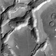
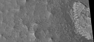
 Part of Noctis Labrynthus as seen by CTX Box shows the area covered by the following HiRISE image
 -
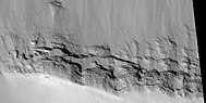
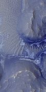
 North and south walls of part of Noctis Labyrinthus, as seen by HiRISE under HiWish program
 -
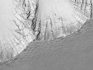
 Wide view of north wall of part of Noctis Labyrinthus, as seen by HiRISE under HiWish program
 -
 Close view of north wall of part of Noctis Labyrinthus, as seen by HiRISE under HiWish program
 -
 Close view of south wall of part of Noctis Labyrinthus, as seen by HiRISE under HiWish program


-
 Mariner 9 view of the Noctis Labyrinthus "labyrinth" at the western end of Valles Marineris on Mars. Linear graben, grooves, and crater chains dominate this region, along with a number of flat-topped mesas. The image is roughly 400 km across, centered at 6 S, 105 W, at the edge of the Tharsis bulge. North is
 -
 Part of Noctis Labyrinthus taken with Mars Global Surveyor. Courtesy NASA/Malin Space Science Systems.
 -
 Layers in the wall of Noctis Labyrinthus taken with Mars Global Surveyor, under the MOC Public Targeting Program. Courtesy NASA/Malin Space Science Systems.
 -
 Layers in the lower portion of two neighbouring buttes within the Noctis Labyrinthus formation on Mars are visible in this image.
 -
 Section of layers near top of Noctis Labyrinthus, as seen by HiRISE under HiWish program
 -
 Group of layers near the bottom of Noctis Labyrinthus, as seen by HiRISE under HiWish program
 -
 Wide view of cliff with layers in Noctis Labyrinthus
 -
 Close-up of part of previous image of layers in Noctis Labyrinthus, as seen by HiRISE under HiWish program
 -
 Wide view of floor of Noctis Labyrinthus, as seen by HiRISE under HiWish program
 -
 Close-up of complex, dark dunes in the previous image of the floor of Noctis Labyrinthus, as seen by HiRISE under HiWish program
 -
 Close-up of some layers in wall of Noctis Labyrinthus, as seen by HiRISE under HiWish program
 -
 Layers on floor of Noctus Labyrinthus, as seen by HiRISE under HiWish program. Layers probably contain a variety of minerals that were formed with groundwater.
 -
 Close-up of layers on floor of Noctis Labyrinthus, as seen by HiRISE under HiWish program. This is an enlargement from the center of the previous picture.
 -
 Layers in a section near the top of wall in Noctis Labyrinthus, as seen by HiRISE under HiWish program
 -
 Floor of Noctis Labyrinthus showing layered structures, as seen by HiRISE under HiWish program
 -
 Layered mesa on floor of Noctis Labyrinthus, as seen by HiRISE under HiWish program Note: this is an enlargement of a previous image.
 -
 Enlargement of edge of mesa on floor of Noctis Labyrinthus showing layers, as seen by HiRISE under HiWish program. Note: this is an enlargement of a previous image.
 -
 Enlargement of a light-toned structure on floor of Noctis Labyrinthus, as seen by HiRISE under HiWish program. Note: this is an enlargement of a previous image.
 -
 Light-toned butte on floor of Noctis Labyrinthus, as seen by HiRISE under HiWish program. Note: this is an enlargement of a previous image.
 -
 Thin dark layers on floor of Noctis Labyrinthus, as seen by HiRISE under HiWish program. Note: this is an enlargement of a previous image.
 -
 Context image for following image of Noctis Labyrinthus, as seen by CTX
 -
 Layers inside Noctis Labyrinthus, as seen by HiRISE under HiWish program
 -
 Layers in Noctis Labyrinthus, as seen by HiRISE under HiWish program


Lava channels

Glaciers
Many of the volcanoes on Mars show strong evidence of past and possible present glacial activity.[8][9][10][11][12][13][14][15][16] When glaciers melt and retreat, they leave behind material that was carried in and on the ice. Often the material is dropped in a ridge, called a

Dark slope streaks
A picture below shows
-
 Aganippe Fossa as seen by HiRISE. Full size image shows layers and streaks.

Research, published in January 2012 in Icarus, found that dark streaks were initiated by airblasts from meteorites traveling at supersonic speeds. The team of scientists was led by Kaylan Burleigh, an undergraduate at the University of Arizona. After counting some 65,000 dark streaks around the impact site of a group of five new craters, patterns emerged. The number of streaks was greatest closer to the impact site, so the impact somehow probably caused the streaks. Also, the distribution of the streaks formed a pattern with two wings extending from the impact site. The curved wings resembled scimitars, curved knives. This pattern suggests that an interaction of airblasts from the group of meteorites shook dust loose enough to start dust avalanches that formed the many dark streaks. At first it was thought that the shaking of the ground from the impact caused the dust avalanches, but if that was the case the dark streaks would have been arranged symmetrically around the impacts, rather than being concentrated into curved shapes.
The crater cluster lies near the equator 510 miles south of Olympus Mons, on a type of terrain called the Medusae Fossae formation. The formation is coated with dust and contains wind-carved ridges called yardangs. These yardangs have steep slopes thickly covered with dust, so when the sonic boom of the airblast arrived from the impacts dust started to move down the slope. Using photos from Mars Global Surveyor and HiRISE camera on NASA's Mars Reconnaissance Orbiter, scientists have found about 20 new impacts each year on Mars. Because the spacecraft have been imaging Mars almost continuously for a span of 14 years, newer images with suspected recent craters can be compared to older images to determine when the craters were formed. Since the craters were spotted in a HiRISE image from February 2006, but were not present in a Mars Global Surveyor image taken in May 2004, the impact occurred in that time frame.
The largest crater in the cluster is about 22 meters (72 feet) in diameter with close to the area of a basketball court. As the meteorite traveled through the Martian atmosphere it probably broke up; hence a tight group of impact craters resulted. Dark slope streaks have been seen for some time, and many ideas have been advanced to explain them. This research may have finally solved this mystery.[25][26]
-
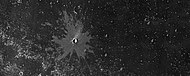
 Image indicates crater cluster and curved lines formed by airblast from meteorites. Meteorites caused airblast which caused dust avalanches on steep slopes. Image is from HiRISE.
 -
 Close up of previous image along light/dark boundary. Dark line in middle of image shows border between light and dark area of curved lines. Green arrows show high areas of ridges. Loose dust moved down steep slopes when it felt the airblast from meteorite strikes. Image is from HiRISE.


Pit crater chains
Pit craters are common near volcanoes in the Tharsis and Elysium system of volcanoes. The image below of Arsia Chasmata contains a pit crater chain.
-
 Arsia Chasmata, as seen by HiRISE. A pit crater chain is visible in the lower right.

Fossa on Mars
Certain areas on Mars possess large troughs (long narrow depressions) called fossae in the geographical language used for Mars. This term is derived from Latin; therefore fossa is singular and fossae is plural.
-
 Fossa (geology)for more information.
 -
 Oti Fossae, as seen by THEMIS. These parallel graben are found on the northeastern side of Arsia Mons; they are in line with the NE/SW trend of the three volcanoes in Tharsis.
 -
 Oti Fossae, as seen by THEMIS. These parallel graben are found on the northeastern side of Arsia Mons; they are in line with the NE/SW trend of the three volcanoes in Tharsis.
 -
 Claritas Fossae as seen by HiRISE. Note the steep scarp.


Volcanoes
The most common form of volcanism on the Earth is basaltic.
The dsovery of a new volcano at the east side of Noctis Labrinthus was announced at a conference in March 2024. It was seen since the early 1970s, but erosion had concealed it from view. There are hints that an adjacent glacier buried underneath the volcanic slopes. The new volcano has a diameter of about 280 miles (450 kilometers and measures roughly 29,600 feet (9,022 meters) in elevation. Note: this mountain is higher than any peak in the United States. Lava flows, pyroclastic deposits (made of volcanic materials such as ash, cinders, pumice and tephra) and hydrothermal mineral deposits occur in several areas nearby.[35] Some of the minerals found in the region are mafic (high Ca pyroxenes, e.g., augite)—these suggest volcanic material. The volcano is located at 7.40°S, 94.60°W. The authors of the paper consider the volcano to be an eroded shield volcano. Sub-circular depressions near the top are interpreted as caldera remnants.[36]
-
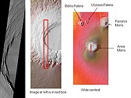
 Map of Phoenicis Lacus quadrangle with major features labeled. This area contains two large volcanoes, Pavonis Mons and Arsia Mons, as well as the famous Noctis Labyrinthus canyon system.
 -
 Arsia Mons showing its position among other volcanoes as seen by THEMIS
 -
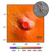 Topography around Arsia Mons
 -
 Arsia Mons, as seen by Mars Global Surveyor
 -
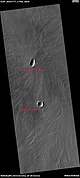
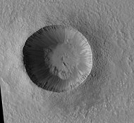
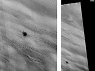
 Small Volcano in Phoenicis Lacus quadrangle. Image is 1.9 miles wide.
 -
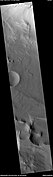
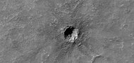
 Volcanic crater (upper) and impact crater (lower). Image about 5 km across.
 -
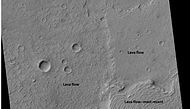 Several lava flows, as seen by HiRISE under HiWish program
 -
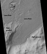 Lava flows moving around higher ground, as seen by HiRISE under HiWish program
 -
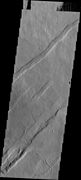
 Lava flow, as seen by HiRISE under HiWish program
 -
 Edge of lava flow, as seen by HiRISE under HiWish program


Craters
-
 Crater showing layers and depression on floor, as seen by HiRISE under HiWish program
 -
 Close view of layers in crater, as seen by HiRISE under HiWish program
 -
 Zumba Crater, as seen by HiRISE. Zumba Crater is a very young crater.
 -
 Small crater, as seen by HiRISE under HiWish program. Much of the ejecta consists of boulders.
 -
 Young crater with bright ejecta in the Phoenicis Lacus quadrangle as seen by HiRISE under HiWish program The impact reached down to a layer that is light-toned. That light-toned material was then deposited on a dark surface.


Other features
-
 Claritas Rupes, as seen by HiRISE. Click on image to see layers. Scale bar is 1000 meters long.
 -
 New Impact that formed between March 2000 and July 2003. Scale bar is 500 meters long. Image taken with HiRISE.
 -
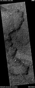
 Channel, as seen by HiRISE under HiWish program. Arrows indicate position of channel in this rather dark photo.


-
 Wide view of mounds and lines, as seen by HiRISE under HiWish program. The lines may be petrified dunes.
 -
 Close, color view of lines from previous image, as seen by HiRISE under HiWish program. Here they look like old dunes. Colors show different minerals.


Other Mars quadrangles

Interactive Mars map

See also
References
- ^ Davies, M.E.; Batson, R.M.; Wu, S.S.C. "Geodesy and Cartography" in Kieffer, H.H.; Jakosky, B.M.; Snyder, C.W.; Matthews, M.S., Eds. Mars. University of Arizona Press: Tucson, 1992.
- ^ Blunck, J. 1982. Mars and its Satellites. Exposition Press. Smithtown, N.Y.
- ^ http://www.mars.asu/christensen/advancedmarsclass/shean_glaciers_2005.pdf[permanent dead link]
- ^ Boyce, J. et al. 2012. Origin of small pits in martian impact craters. Icarus. 221: 262-275.
- ^ Tornabene, L. et al. 2012. Widespread crater-related pitted materials on Mars. Further evidence for the role of target volatiles during the impact process. Icarus. 220: 348-368.
- ^ "Trough deposits on Mars point to complex hydrologic past". Sciencedaily.com. 2009-12-17. Retrieved 2011-03-28.
- ^ "A Suite of Features | Mars Odyssey Mission THEMIS".
- ^ Scanlon,K., J. Head, D. Marchant. 2015. REMNANT BURIED ICE IN THE ARSIA MONS FAN-SHAPED DEPOSIT, MARS. 46th Lunar and Planetary Science Conference. 2266.pdf
- ^ Kadish S. J. et al. 2014. PSS, 91, 52-59.
- ^ Williams R. 1978. Geol. Soc. Am. Abst. with Programs, 10, 517.
- ^ Lucchitta B. 1981. Icarus, 45(2), 264-303.
- ^ Head J., D. Marchant. 2003. Geology, 31(7), 641-644.
- ^ Shean D., et al. 2007. JGR:Planets, 112(E3).
- ^ Kadish S., et al. 2008. Icarus, 197(1), 84-109.
- ^ Scanlon K., et al. 2014. Icarus, 237, 315–339.
- ^ Scanlon K., et al. 2015. Icarus, 250, 18-31.
- ^ "Alpine glaciers (Released 27 August 2003) | Mars Odyssey Mission THEMIS".
- ^ http://www.space.com/image_of_day_080730.html [dead link]
- ^ "spcae.com". spcae.com. Retrieved 2011-03-28.
- ^ http://www.space.com/scienceastronomy/streaks_mars_streaks_030328.html [dead link]
- ^ http://www.space.com/scienceastronomy/mars_ [dead link]
- ^ "Mars Spirit Rover Gets Energy Boost From Cleaner Solar Panels". Sciencedaily.com. 2009-02-19. Retrieved 2011-03-28.
- ISBN 0-517-00192-6.
- ISBN 978-0-8165-1257-7. Retrieved 7 March 2011.
- ^ "Home". redplanet.asu.edu.
- ^ a b Skinner, J., L. Skinner, and J. Kargel. 2007. Re-assessment of Hydrovolcanism-based Resurfacing within the Galaxias Fossae Region of Mars. Lunar and Planetary Science XXXVIII (2007)
- ^ a b Wyrick, D., D. Ferrill, D. Sims, and S. Colton. 2003. Distribution, Morphology and Structural Associations of Martian Pit Crater Chains. Lunar and Planetary Science XXXIV (2003)
- ^ http://www.swri.edu/4org/d20/DEMPS/planetgeo/planetmars.html[permanent dead link]
- ^ "Mars Global Surveyor MOC2-620 Release". Msss.com. 2004-01-29. Retrieved 2011-03-28.
- ^ "Mars Art Gallery Martian Feature Name Nomenclature". Marsartgallery.com. Retrieved 2011-03-28.
- ^ "HiRISE | Craters and Pit Crater Chains in Chryse Planitia (PSP_008641_2105)". Hirise.lpl.arizona.edu. Retrieved 2011-03-28.
- ^
- Carr, Michael H. (2006). The Surface of Mars. New York: Cambridge University Press. ISBN 978-0-521-87201-0.
- Carr, Michael H. (2006). The Surface of Mars. New York: Cambridge University Press.
- ^ Khayat, A., et al. 2017. A deep search for the release of volcanic gases on Mars using ground-based high-resolution infrared and submillimeter spectroscopy: Sensitive upper limits for OCS and SO2. Icarus: 296, 1-14.
- ^ https://www.space.com/mars-giant-volcano-hiding-plain-sight?utm_term=CABA215D-3D47-4C9A-92FE-9ECF8D4C7909&lrh=e62336263a3610a07ef7c8af2080c758f2ecd0661aab1a8e6234cf31f0d0fdff&utm_campaign=58E4DE65-C57F-4CD3-9A5A-609994E2C5A9&utm_medium=email&utm_content=DBDE44BA-0009-4913-99AB-1A1AD0DC4FF9&utm_source=SmartBrief
- ^ https://www.hou.usra.edu/meetings/lpsc2024/pdf/2745.pdf
- ISBN 0-312-24551-3.
- ^ "Online Atlas of Mars". Ralphaeschliman.com. Retrieved December 16, 2012.
- ^ "PIA03467: The MGS MOC Wide Angle Map of Mars". Photojournal. NASA / Jet Propulsion Laboratory. February 16, 2002. Retrieved December 16, 2012.