
Oxia Palus quadrangle
 Map of Oxia Palus quadrangle from Mars Orbiter Laser Altimeter (MOLA) data. The highest elevations are red and the lowest are blue. | |
| Coordinates | 15°00′N 22°30′W / 15°N 22.5°W |
|---|---|

The Oxia Palus quadrangle is one of a series of 30 quadrangle maps of Mars used by the United States Geological Survey (USGS) Astrogeology Research Program. The Oxia Palus quadrangle is also referred to as MC-11 (Mars Chart-11).[1]
The quadrangle covers the region of 0° to 45° west longitude and 0° to 30° north latitude on Mars. This quadrangle contains parts of many regions: Chryse Planitia, Arabia Terra, Xanthe Terra, Margaritifer Terra, Meridiani Planum and Oxia Planum.
Mars Pathfinder landed in the Oxia Palus quadrangle at 19°08′N 33°13′W / 19.13°N 33.22°W, on July 4, 1997, at the intersection Tiu Valles and Ares Vallis.
Many craters within Oxia Palus are named after famous scientists. Besides
Mawrth Vallis was strongly considered as a landing site for NASA's Curiosity rover, the Mars Science Laboratory.[3] It made it to at least the top two sites for NASA's EXoMars 2020 Rover mission. The exact location proposed for this landing is 22.16 N and 342.05 E.[4]
The Mawrth Vallis region is well studied with more than 40 papers published in peer-reviewed publications. Near the Mawrth channel is a 200 meter high plateau with many exposed layers. Spectral studies have detected clay minerals that present as a sequence of layers.[5][6][7][8][9][10][11][12][13][14][15] Clay minerals were probably deposited in the Early to Middle
Another site in the Oxia Palus quadrangle has been picked for the EXoMars 2020 landing is at 18.14 N and 335.76 E. This site is of interest because of a long-duration aqueous system including a delta, possible biosignatures, and a variety of clays.[4][17][18]
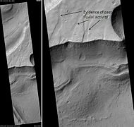
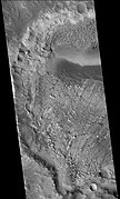
This quadrangle contains abundant evidence for past water in such forms as river valleys, lakes, springs, and chaos areas where water flowed out of the ground. A variety of clay minerals have been found in Oxia Palus. Clay is formed in water, and it is good for preserving microscopic evidence of ancient life.[19] Recently, scientists have found strong evidence for a lake located in the Oxia Palus quadrangle that received drainage from Shalbatana Vallis. The study, carried out with HiRISE images, indicates that water formed a 30-mile-long canyon that opened up into a valley, deposited sediment, and created a delta. This delta and others around the basin imply the existence of a large, long-lived lake. Of special interest is evidence that the lake formed after the warm, wet period was thought to have ended. So, lakes may have been around much longer than previously thought.
Surface appearance
The Mars Pathfinder found its landing site to contain a great deal of rocks. Analysis shows the area to have a greater density of rocks than 90% of Mars. Some of the rocks leaned against each other in a manner geologists term imbricated. It is believed strong flood waters in the past pushed the rocks around to face away from the flow. Some pebbles were rounded, perhaps from being tumbled in a stream. Some rocks have holes on their surfaces that seem to have been fluted by wind action. Small sand dunes are present. Parts of the ground are crusty, maybe due to cementing by a fluid containing minerals. In general the rocks show a dark gray color with patches of red dust or weathered appearance on their surfaces. Dust covers the lower 5–7 cm of some rocks, so they may have once been buried, but have now become exhumed. Three knobs, one large crater, and two small craters were visible on the horizon.[27]
Types of rocks
Results of Mars Pathfinder's
By the time that final results of the mission were described in a series of articles in the journal Science (December 5, 1997), it was believed that the rock Yogi contained a coating of dust, but was similar to the rock Barnacle Bill. Calculations suggest that the two rocks contain mostly the minerals
-
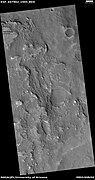
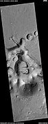
 Map of Oxia Palus labeled with major features
 -
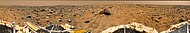 View from Mars Pathfinder
 -


Other results from Pathfinder
By taking multiple images of the sky at different distances from the sun, scientists were able to determine that size of the particles in the pink haze was about 1 micrometer in radius. The color of some soils was similar to that of an iron oxyhydroxide phase which would support a warmer and wetter climate in the past.[30] Pathfinder carried a series of magnets to examine the magnetic component of the dust. Eventually, all but one of the magnets developed a coating of dust. Since the weakest magnet did not attract any soil, it was concluded that the airborne dust did not contain pure magnetite or one type of maghemite. The dust probably was an aggregate possible cemented with ferric oxide (Fe2O3).[31]
Winds were usually less than 10 m/s. Dust devils were detected in the early afternoon. The sky had a pink color. There was evidence of clouds and maybe fog.[27]
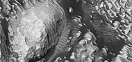
River valleys and chaos
Many large, ancient river valleys are found in this area; along with collapsed features, called Chaos. The Chaotic features may have collapsed when water came out of the surface. Martian rivers begin with a Chaos region. A chaotic region can be recognized by a rat's nest of mesas, buttes, and hills, chopped through with valleys which in places look almost patterned. Some parts of this chaotic area have not collapsed completely—they are still formed into large mesas, so they may still contain water ice.[32] Chaotic terrain occurs in numerous locations on Mars, and always gives the strong impression that something abruptly disturbed the ground. More information and more examples of chaos can be found at Chaos terrain. Chaos regions formed long ago. By counting craters (more craters in any given area means an older surface) and by studying the valleys' relations with other geological features, scientists have concluded the channels formed 2.0 to 3.8 billion years ago.[33]
One generally accepted view for the formation of large outflow channels is that they were formed by catastrophic floods of water released from giant groundwater reservoirs. Perhaps, the water started to come out of the ground due to faulting or volcanic activity. Sometimes hot magma just travels under the surface. If that is the case, the ground will be heated, but there may be no evidence of lava at the surface. After water escapes, the surface collapses. Moving across the surface, the water would have simultaneously frozen and evaporated. Chunks of ice that would have rapidly formed may have enhanced the erosive power of the flood. Furthermore, the water may have frozen over at the surface, but continuing to flow underneath, eroding the ground as it moved along. Rivers in cold climates on the Earth often become ice-covered, yet continue to flow.
Such catastrophic floods have occurred on Earth. One commonly cited example is the
Lakes
Research, published in January 2010, suggests that Mars had lakes, each around 20 km wide, along parts of the equator, in the Oxia Palus quadrangle. Although earlier research showed that Mars had a warm and wet early history that has long since dried up, these lakes existed in the Hesperian Epoch, a much earlier period. Using detailed images from NASA's Mars Reconnaissance Orbiter, the researchers speculate that there may have been increased volcanic activity, meteorite impacts, or shifts in Mars' orbit during this period to warm Mars' atmosphere enough to melt the abundant ice present in the ground. Volcanoes would have released gases that thickened the atmosphere for a temporary period, trapping more sunlight and making it warm enough for liquid water to exist. In this new study, channels were discovered that connected lake basins near Ares Vallis. When one lake filled up, its waters overflowed the banks and carved the channels to a lower area where another lake formed.[35][36] These lakes would be another place to look for evidence of present or past life.
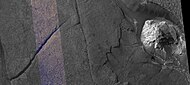
Aram Chaos
-
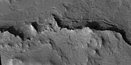
 Erosion in Aram Chaos, as seen by THEMIS
 -
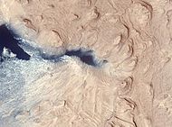
 Blocks in Aram showing possible source of water, as seen by THEMIS


-
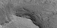
 Hanging valleys in Aram Chaos, as seen by HiRISE under HiWish program
 -
 Wide view of Aram Chaos, as seen by HiRISE under the HiWish program. The black strip is where data was not gathered.
 -
 Aram Chaos with a light toned mound as seen by HiRISE under the HiWish program. The mound probably contains water bearing minerals.
 -
 Light toned mound as seen by HiRISE under the HiWish program. The mound probably contains water bearing minerals.


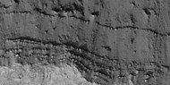
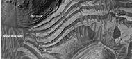
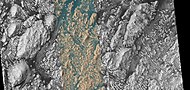
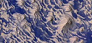
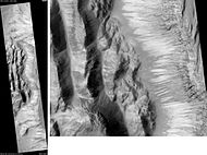
Layered sediments
Oxia Palus is an interesting area with many craters showing layered sediments.
The pattern of layers within layers measured in Becquerel crater suggests that each layer was formed over a period of about 100,000 years. Moreover, every 10 layers can be grouped into larger bundles. So every 10-layer pattern took one million years to form (100,000 years/layer × 10 layers). The ten-layer pattern is repeated at least ten times, that is there are least ten bundles, each consisting of ten layers. It is believed that the layers relate to the cycle of changing tilt of Mars.
The tilt of the Earth's axis changes by only a little more than 2 degrees. In contrast, Mars's tilt varies by tens of degrees. Today, the tilt (or obliquity) of Mars is low, so the poles are the coldest places on the planet, while the equator is the warmest. This causes gases in the atmosphere, like water and carbon dioxide, to migrate poleward, where they turn into ice. When the obliquity is higher, the poles receive more sunlight, and those materials migrate away. When carbon dioxide moves from the poles, the atmospheric pressure increases, maybe causing a difference in the ability of winds to transport and deposit sand. With more water in the atmosphere, sand grains deposited on the surface may stick and cement together to form layers. This study was done using stereo topographic maps obtained by processing data from the high-resolution camera onboard NASA's Mars Reconnaissance Orbiter.[40]
A detailed discussion of layering with many Martian examples can be found in Sedimentary Geology of Mars.[41]
-
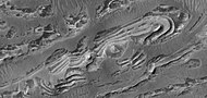
 Buttes, as seen by HiRISE under HiWish program. Buttes have layered rocks with a hard resistant cap rock on the top which protects the underlying rocks from erosion.
 -

-
 Mounds in craters showing layers are formed by the erosion of layers that were deposited after the impact.
 -
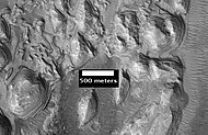
 Punsk Crater, as seen by HiRISE. Scale bar is 500 meters long. Click on image to see possible fine layers on floor. Image on right is an enlargement of south (bottom) wall of crater.
 -
 Hydraotes Chaos, as seen by HiRISE. Click on image to see channels and layers. Scale bar is 1000 meters long.
 -
 Grindavik Crater, as seen by HiRISE. Scale bar is 1000 meters long.
 -
 Layers in Monument Valley. These are accepted as being formed, at least in part, by water deposition. Since Mars contains similar layers, water remains as a major cause of layering on Mars.
 -
 Layered mesas, as seen by HiRISE underTerra Meridiani.
 -
 Close-up of one of the mesas in previous photo showing layers. Mesa may be the remains of a lake in which sediments were deposited. Picture obtained with HiRISE, under HiWish program.
 -
 Wide view of layers, as seen by HiRISE under HiWish program
 -
 Close view of layers, as seen by HiRISE under HiWish program


-
 Wide view of layered features, as seen by HiRISE under HiWish program
 -
 Close view of layered features, as seen by HiRISE under HiWish program


-
 Wide view of layered features and ridges, as seen by HiRISE under HiWish program
 -
 Close view of layers, as seen by HiRISE under HiWish program
 -
 Close view of layers, as seen by HiRISE under HiWish program
 -
 Close view of layers, as seen by HiRISE under HiWish program
 -
 Close view of layers in a mound, as seen by HiRISE under HiWish program
 -
 Close view of layers, as seen by HiRISE under HiWish program
 -
 Small sets of layers in Aram Chaos, as seen by HiRISE under HiWish program
 -
 Layers and yardangs, as seen by HiRISE under HiWish program. Arrows point to some yardangs.


-
 Wide view of layers in a depression near Shalbatana Vallis, as seen by HiRISE under HiWish program
 -
 Close view of layers in a depression near Shalbatana Vallis, as seen by HiRISE under HiWish program
 -
 Close view of layers in a depression near Shalbatana Vallis, as seen by HiRISE under HiWish program


-
 Wide view of layers, as seen by HiRISE under HiWish program
 -
 Close view of layers, as seen by HiRISE under HiWish program
 -
 Close view of layers, as seen by HiRISE under HiWish program. Box shows size of football field.
 -
 Close view of layers, as seen by HiRISE under HiWish program
 -
 Close view of layers, as seen by HiRISE under HiWish program. A fault is visible.
 -
 Close view of layers, as seen by HiRISE under HiWish program
 -
 Close view of layers, as seen by HiRISE under HiWish program
 -
 Layers, as seen by HiRISE under HiWish program
 -
 Wide view of various shapes created by erosion, as seen by HiRISE under HiWish program
 -
 Close color view of layered mesa and mound, as seen by HiRISE
 -
 Close view of edge of layered mesa, as seen by HiRISE
 -
 Close view of layered mesa with pyramid shapes, as seen by HiRISE under HiWish program
 -
 Wide view of layers in Danielson Crater, as seen by HiRISE under HiWish program
 -
 Close view of top of image of Danielson Crater, as seen by HiRISE (ESP_071634_1880)
 -
 Close view of top of image of Danielson. Arrows indicate parts that are enlarged.
 -
 Layers in Danielson Crater with enlargements of some spots (indicated with arrows)
 -
 Layers in Danielson Crater with enlargements of some spots (indicated with arrows)
 -
 Layers in Danielson Crater, as seen by HiRISE under HiWish program
 -
 Layers in Danielson Crater, as seen by HiRISE under HiWish program


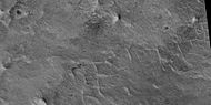
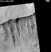
Linear ridge networks
Linear ridge networks are found in various places on Mars in and around craters.[42] Ridges often appear as mostly straight segments that intersect in a lattice-like manner. They are hundreds of meters long, tens of meters high, and several meters wide. It is thought that impacts created fractures in the surface, these fractures later acted as channels for fluids. Fluids cemented the structures. With the passage of time, surrounding material was eroded away, thereby leaving hard ridges behind. Since the ridges occur in locations with clay, these formations could serve as a marker for clay which requires water for its formation.[43][44][45] Water here could have supported past life in these locations. Clay may also preserve fossils or other traces of past life.
-
 Possible dikes and layered structures, as seen by HiRISE under HiWish program. These may be part of linear ridge networks that are produced with impact craters.
 -
 Possible fault along a butte, as seen by HiRISE under HiWish program. These may be part of linear ridge networks that are produced with impact craters.


-
 Layers and ridge networks, as seen by HiRISE under HiWish program
 -
 Layers in a mound and ridge networks, as seen by HiRISE under HiWish program
 -
 Ridge networks of various sizes, as seen by HiRISE under HiWish program
 -
 Ridge networks, as seen by HiRISE under HiWish program


Wrinkle ridges

Many areas of Mars show wrinkles on the surface, called wrinkle ridges. They are elongated and are often found on smooth area of Mars. Because they are wide, gentle topographic highs, they are sometimes hard to see. Although first thought to be caused by
Faults

A picture below right, taken of layers in Becquerel Crater, shows a straight line that represents a fault.[47] Faults are breaks in rocks where movement has taken place. The movement may be only inches or much more. Faults can be very significant, as the break in the rock is a focus for erosion and, more importantly, can allow fluids containing dissolved minerals to rise, then be deposited. Some of the major ore deposits on Earth are formed by this process.
-
 Faults in Danielson Crater, as seen by HiRISE under HiWish program
 -
 Faults and layers in Danielson Crater, as seen by HiRISE under HiWish program


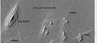
Springs
A study of images taken with the High Resolution Imaging Science Experiment (
-
 Vernal Crater, as seen by CTX camera (on Mars Reconnaissance Orbiter)
 -
 Springs inHIRISE


Craters
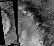
Mojave crater
The crater Mojave, in the Xanthe Terra region, has alluvial fans that look remarkably similar to landforms in the Mojave Desert in the American southwest. As on Earth, the largest rocks are near the mouths of the fans. Because channels start at the tops of ridges, it is believed they were formed by heavy downpours. Researchers have suggested that the rain may have been initiated by impacts.[50]
Mojave is approximately 2,604 meters (1.618 miles) deep. Its depth relative to its diameter and its
-
 Alluvial Fans in Mojave, as seen by HiRISE. The crater rim is on the right. A branched network of channels runs down towards the left.
 -
 Another view of Mojave from HiRISE (north is at bottom)


Firsoff Crater
-
 MOLA map showingFirsoff Craterand other nearby craters. Colors indicate elevations.
 -
 Layers in Firsoff Crater, as seen by HiRISE
 -
 Close-up of layers in Firsoff Crater, as seen by HiRISE Note: this is an enlargement of the previous image of Firsoff Crater.
 -
 Top part of previous images, as seen by HiRISE. Note: dark parts are basalt sand.
 -
 Fault across layers in a mesa in Firsoff Crater, as seen by HiRISE under HiWish program
 -
 Close-up of layers in Firsoff Crater, as seen by HiRISE under HiWish program
 -
 Wide view of layered surface in Firsoff Crater, as seen by HiRISE under HiWish program
 -
 Layers in Firsoff crater with a box showing the size of a football field. Picture taken by HiRISE under HiWish program.
 -
 Layers and faults in Firsoff Crater, as seen by HiRISE under HiWish program. Arrows show one large fault, but there are other smaller ones in the picture.
 -
 Layered mound, as seen by HiRISE under HiWish program. The white box represents the size of a football field for scale.


Crommelin Crater
-
 Crommelin (Martian crater), as seen by CTX camera (on Mars Reconnaissance Orbiter)
 -
 Crommelin crater showing layers anddust devil tracks, as seen by CTX camera (on Mars Reconnaissance Orbiter). Note: this is an enlargement of a previous image of Crommelin crater.
 -
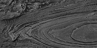
 Crommelin crater showing layers arranged in the shape of ovals, as seen by CTX camera (on Mars Reconnaissance Orbiter). Note: this is an enlargement of a previous image of Crommelin crater.
 -
 Crommelin crater showing layers in buttes and inside a small crater, as seen by CTX camera (on Mars Reconnaissance Orbiter). Note: this is an enlargement of a previous image of Crommelin crater.
 -
 Crommelin crater, showing layers, as seen by HiRISE
 -
 Butte in Crommelin (Martian crater), as seen by HiRISE under HiWish program. Location is Oxia Palus quadrangle.
 -
 Layers in Crommelin Crater, as seen by HiRISE under HiWish program. Location is Oxia Palus quadrangle.
 -
 Layers in Crommelin Crater, as seen by HiRISE under HiWish program Arrow indicates fault. Location is Oxia Palus quadrangle.
 -
 Crommelin Crater Layered Deposit, as seen by HiRISE. The color blue in the photo is a false color.


-
 Wide view of layers in Crommelin crater, as seen by HiRISE under HiWish program. Parts of this photo are enlarged in following images.
 -
 Close view of layered mound in Crommelin crater, as seen by HiRISE under HiWish program. Box indicates the size of a football field for scale.
 -
 Close view of layers in Crommelin crater, as seen by HiRISE under HiWish program
 -
 Close view of layers in Crommelin crater, as seen by HiRISE under HiWish program
 -
 Close view of layers in Crommelin crater, as seen by HiRISE under HiWish program. Arrow points to a fault.
 -
 Close view of layers in Crommelin crater, as seen by HiRISE under HiWish program
 -
 Close view of layers in Crommelin crater, as seen by HiRISE under HiWish program. Arrow points to a fault.


Danielson Crater
-
 West side ofDanielson Crater, as seen by CTX camera (on Mars Reconnaissance Orbiter). Danielson has a great deal of regular layering.
 -
 Some of the layers of Danielson Crater is just visible in this CTX image. Dunes are also visible.
 -
 Many layers are visible in this HiRISE image of Danielson Crater. Dark dust serves to highlight some of the layers.
 -
 Wide-view of layers in Danielson Crater, as seen by HiRISE under HiWish program. Box shows location of next image. Dark parts of image are dark, basalt sand sitting on level places.
 -
 Enlargement of previous image of Danielson Crater showing a fault and layers. Image taken with HiRISE, under HiWish program.
 -
 Wide view of part of Danielson Crater, as seen by HiRISE under HiWish program
 -
 Enlargement of previous image of Danielson Crater, as seen by HiRISE under HiWish program. The box represents the size of a football field.
 -
 Close up of layers in Danielson Crater, as seen by HiRISE under HiWish program—boulders are visible, as well as dark sand
 -
 Layers in Danielson Crater with dust devil tracks at the top of the picture, as seen by HiRISE under HiWish program


-
 Wide view of layers in Danielson Crater, as seen by HiRISE under HiWish program
 -
 Wide view of layers in Danielson Crater, as seen by HiRISE under HiWish program. Center color band of the HiRISE image is visible.
 -
 Layers in Danielson Crater, as seen by HiRISE under HiWish program. Scale is shown.
 -
 Layers and dark dust in Danielson Crater, as seen by HiRISE under HiWish program
 -
 Layers and dark dust in Danielson Crater, as seen by HiRISE under HiWish program
 -
 Layers, crater, and mounds on floor of Danielson Crater, as seen by HiRISE under HiWish program
 -
 Close view of crater on floor of Danielson Crater, as seen by HiRISE under HiWish program
 -
 Layered mound on floor of Danielson Crater, as seen by HiRISE under HiWish program
 -
 Close, color view of layers and dark dust on floor of Danielson Crater, as seen by HiRISE under HiWish program
 -
 Close, color view of layers and dark dust on floor of Danielson Crater, as seen by HiRISE under HiWish program. Boulders are visible in the image.
 -
 Close, color view of layers and dark dust on floor of Danielson Crater, as seen by HiRISE under HiWish program. Faults are indicated with arrows.
 -
 Close view of layers on floor of Danielson Crater, as seen by HiRISE under HiWish program. Some faults are visible in image.
 -
 Close, color view of layers and dark dust on floor of Danielson Crater, as seen by HiRISE under HiWish program. Some small faults are visible in image.


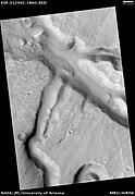
Pedestal crater
A pedestal crater is a crater with its ejecta sitting above the surrounding terrain and thereby forming a raised platform (like a pedestal). They form when an impact crater ejects material which forms an erosion-resistant layer, thus causing the immediate area to erode more slowly than the rest of the region. Some pedestals have been accurately measured to be hundreds of meters above the surrounding area. This means that hundreds of meters of material were eroded away. The result is that both the crater and its ejecta blanket stand above the surroundings. Pedestal craters were first observed during the Mariner missions.[52][53][54][55]
-
 Pedestal Crater and ridge in Oxia Palus quadrangle, as seen by HiRISE. Click on image to see detail of the edge of the pedestal crater. The flat-topped ridge near the top of the image was once a river that became inverted. The pedestal crater superposes the ridge, so it is younger.
 -
 Pedestal craters form when the ejecta from impacts protect the underlying material from erosion. As a result of this process, craters appear perched above their surroundings.
 -
 Drawing shows a later idea of how some pedestal craters form. In this way of thinking, an impacting projectile goes into an ice-rich layer—but no further. Heat and wind from the impact hardens the surface against erosion. This hardening can be accomplished by the melting of ice which produces a salt/mineral solution thereby cementing the surface.


-
 Wide CTX image of layers under the ejecta surface of a pedestal crater
 -
 Layers under top layer of pedestal crater, as seen by HiRISE under HiWish program
 -
 Close view of layers under ejecta surface of pedestal crater, as seen by HiRISE under HiWish program
 -
 Close view of layers under ejecta surface of pedestal crater, as seen by HiRISE under HiWish program


Other craters
Impact craters generally have rims with ejecta around them; in contrast volcanic craters usually do not have a rim or ejecta deposits. As craters get larger (greater than 10 km in diameter) they usually have a central peak.[56] The peak is caused by a rebound of the crater floor following the impact.[46] Sometimes craters display layers. Since the collision that produces a crater is like a powerful explosion, rocks from deep underground are tossed onto the surface. Hence, craters can show what lies deep under the surface.
-
 Trouvelot Crater floor, as seen by HiRISE
 -
 Central peak ofRadau Crater, as seen by HiRISE
 -
 Kipini Cratersouth rim, as seen by HiRISE. Scale bar is 500 meters long.
 -
 Sagan CraterCentral Peak Ring, as seen by HiRISE. Scale bar is 500 meters long.
 -
 Curie Crater, as seen by HiRISE
 -
 Close-up of layers in central mound of Curie Crater, as seen by HiRISE. Layers may have formed in a lake.
 -
 Tayray Crater, as seen by HiRISE
 -
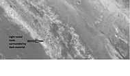 Light toned rocks surrounded by dark material along wall of a crater, as seen by HiRISE under HiWish program. Click on image for a better view.
 -
 Western side ofRutherford Crater, as seen by CTX camera (on Mars Reconnaissance Orbiter). Light-toned deposits are visible.
 -
 Dunes on floor of Rutherford Crater, as seen by CTX camera (on Mars Reconnaissance Orbiter). Note: this is an enlargement of the previous image.
 -
 Da Vinci (Martian crater), as seen by CTX camera (on Mars Reconnaissance Orbiter)
 -
 Masursky CraterFloor, as seen by HiRISE
 -
 Marth Crater, as seen by CTX camera (on Mars Reconnaissance Orbiter).
 -
 Marth Crater showing dunes, as seen by CTX camera (on Mars Reconnaissance Orbiter). Note: this is an enlargement of the previous image of Marth Crater.
 -
 Ejecta margin of unnamed crater, as seen by HiRISE under HiWish program
 -
 Eroded craters, as seen by HiRISE. One crater is half eroded away. Another crater has eroded to form a tall, thin rim, and its ejecta has been eroded away. This image is part of an image that was named HiRISE picture of the day.
 -
 One crater here has a depression on its floor. This may be due to the impacting body going down to a softer material.


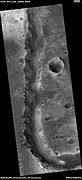
Vallis
Vallis (plural valles) is the Latin word for valley. It is used in planetary geology for the naming of landform features on other planets.
Vallis was used for old river valleys that were discovered on Mars, when probes were first sent to Mars. The Viking Orbiters caused a revolution in our[who?] ideas about water on Mars; huge river valleys were found in many areas. Spacecraft cameras showed that floods of water broke through dams, carved deep valleys, eroded grooves into bedrock, and traveled thousands of kilometers.[46][57][58]
-
 Shalbatana Vallis, as seen by HiRISE. The scale bar is 500 meters long.
 -
 Shalbatana Vallis Floor, as seen by HiRISE. Scale bar is 1000 meters long.
 -
 Close-up of Simud Valles, as seen by HiRISE
 -
 Ares Vallis, as seen by Viking. The channel is 25 km wide and about 1 km deep.
 -
 Channels in Ares Vallis Region, as seen by HiRISE
 -
 Ares Valles, as seen by HiRISE
 -
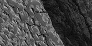
 Tiu Valles Ridges, as seen by HiRISE. Ridges were probably formed by running water. Scale bar is 1 km long.
 -
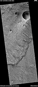
 Teardrop-shaped islands caused by flood waters fromGold Crater.
 -
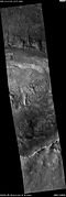
 Valley, as seen by HiRISE under HiWish program


-
Hanging valleys in Aram Chaos, as seen by HiRISE under HiWish program
Other close-up images
-
 Mars Odyssey THEMIS.
 -
 Eos Chasma with a Mensa, a flat topped prominence with cliff-like edges, as seen by THEMIS. In many places rock layers are visible.
 -
 Hydaspis Chaos, as seen by HiRISE
 -
 Chaos along Shalbatana Vallis as seen by HiRISE under HiWish program
 -
 Cyclic Bedding in Arabia Terra, as seen by HiRISE
 -
 Cliffs and canyons in Arabia, as seen by HiRISE
 -
 Cap rock breaking up into large blocks, as seen by HiRISE under HiWish program
 -
 Rock breaking up into large blocks, as seen by HiRISE under HiWish program
 -
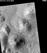
 FPyramid shapes in Oxia Palus quadrangle


Cultural significance
A large part of the popular movie The Martian takes place in the Oxia Palus quadrangle.
-
 Much of the astronaut's journey takes place in Oxia Palus quadrangle.

Other Mars quadrangles

Interactive Mars map

See also
References
- ^ Davies, M.E.; Batson, R.M.; Wu, S.S.C. "Geodesy and Cartography" in Kieffer, H.H.; Jakosky, B.M.; Snyder, C.W.; Matthews, M.S., Eds. Mars. University of Arizona Press: Tucson, 1992.
- ^ U.S. department of the Interior U.S. Geological Survey, Topographic Map of the Eastern Region of Mars M 15M 0/270 2AT, 1991
- ^ http://www.space.com/missionlaunches/mars-science-laboratory-curiosity-landing-sites-100615.htm[permanent dead link]
- ^ a b https://www.hou.usra.edu/meetings/lpsc2018/eposter/2177.pdf [bare URL PDF]
- S2CID 7465822.
- ^ Loizeau et al. 2007. JGR 112, E08S08
- S2CID 32231092.
- ^ Noe Dobrea et al. 2010. JGR 115, E00D19
- ^ Michalski, Noe Dobrea. 2007. Geol. 35, 10.
- .
- .
- .
- .
- .
- PMID 20950170.
- ^ Gross, C. et al. 2016. MAWRTH VALLIS – PROPOSED LANDING SITE FOR EXOMARS 2018/2020. 47th Lunar and Planetary Science Conference (2016) 1421.pdf
- ^ ] Quantin C. et al. (2014) ExoMars LSSW#1
- ^ "ESA - Robotic Exploration of Mars".
- ^ http://themis.asu.edu/features/marwrthvillis[permanent dead link]
- ^ "CU Researchers Find First Definitive Evidence for Ancient Lake on Mars | News Center | University of Colorado at Boulder". Archived from the original on 2011-12-29. Retrieved 2009-06-18.
- ^ "Evidence Found for Ancient Mars Lake". Space.com. Archived from the original on 2009-06-21. Retrieved 2009-06-18.
- Arizona University. Retrieved October 21, 2015.
- ^ Amos, Jonathan (October 21, 2015). "ExoMars rover: Landing preference is for Oxia Planum". BBC News. Retrieved October 22, 2015.
- ^ Atkinson, Nancy (October 21, 2015). "Scientists Want ExoMars Rover to Land at Oxia Planum". Universe Today. Retrieved October 22, 2015.
- ^ Quantin, C. et al. 2015. EPSC2015-704
- ^ Quantin C. et al. (2015) ExoMars LSSW#
- ^ a b c d Golombek, M. et al. 1997. Overview of the Mars Pathfinder Mission and Assessment of Landing Site Predictions. Science: 278. pp. 1743–1748
- ^ a b APXS Composition Results (NASA NSSDC)
- ^ a b Bruckner, J., G. Dreibus, R. Rieder, and H. Wanke. 2001. Revised Data of the Mars Pathfinder Alpha Proton X-ray spectrometer: Geochemical Behavior of Major and Minor Elements. Lunar and Planetary Science XXXII
- ^ Smith, P. et al. 1997. Results from the Mars Pathfinder Camera Science: 278. 1758-1765
- ^ Hviid, S. et al. 1997. Magnetic Properties Experiments on the Mars Pathfinder Lander: Preliminary Results. Science:278. 1768-1770.
- ^ "Unraveling the Chaos of Aram | Mars Odyssey Mission THEMIS".
- ^ "Mars Odyssey Mission THEMIS: Feature Image: Volcanism and Collapse in Hydraotes". Archived from the original on 2010-01-20. Retrieved 2009-02-15.
- ^ "Mars Channels and Valleys".
- ^ "Spectacular Mars Images Reveal Evidence of Ancient Lakes". Science Daily. Archived from the original on 2016-08-23. Retrieved 2018-03-09.
- ^ Sanjeev Gupta, Nicholas Warner, Jung-Rack Kim, Shih-Yuan Lin, Jan Muller. 2010. Hesperian equatorial thermokarst lakes in Ares Vallis as evidence for transient warm conditions on Mars. Geology: 38. 71-74.
- ^ "Mars Odyssey Mission THEMIS: Discoveries". Archived from the original on 2009-02-19. Retrieved 2009-02-15.
- ^ Grotzinger, J. and R. Milliken (eds.) 2012. Sedimentary Geology of Mars. SEPM
- ^ "THEMIS: Image Detail". Archived from the original on 2005-03-22. Retrieved 2009-02-15.
- ^ "Sorry - You Seem to Have Lost Your Way - SpaceRef". Archived from the original on 2012-09-12. Retrieved 2022-02-15.
- ^ Grotzinger, J. and R. Milliken (eds.). 2012. Sedimentary Geology of Mars. SEPM.
- ^ Head, J., J. Mustard. 2006. Breccia dikes and crater-related faults in impact craters on Mars: Erosion and exposure on the floor of a crater 75 km in diameter at the dichotomy boundary, Meteorit. Planet Science: 41, 1675-1690.
- S2CID 15188454.
- ^ Mustard et al., 2007. Mineralogy of the Nili Fossae region with OMEGA/Mars Express data: 1. Ancient impact melt in the Isidis Basin and implications for the transition from the Noachian to Hesperian, J. Geophys. Res., 112.
- S2CID 17913229.
- ^ ISBN 978-0-8165-1257-7. Retrieved 7 March 2011.
- ^ "HiRISE | Layered Deposits in Becquerel Crater (PSP_004078_2015)".
- PMID 19093802.
- ^ http://hirise.lpl.arizona.edu/PSO_002812_1855[permanent dead link]
- ^ "HiRISE | Alluvial Fans in Mojave Crater: Did It Rain on Mars? (PSP_001415_1875)".
- S2CID 206553043.
- ^ http://hirise.lpl.eduPSP_008508_1870[permanent dead link]
- ^ Bleacher, J. and S. Sakimoto. Pedestal Craters, A Tool For Interpreting Geological Histories and Estimating Erosion Rates. LPSC
- ^ "Mars Odyssey Mission THEMIS: Feature Image: Pedestal Craters in Utopia". Archived from the original on January 18, 2010. Retrieved March 26, 2010.
- .
- ^ "Stones, Wind, and Ice: A Guide to Martian Impact Craters".
- ^ Raeburn, P. 1998. Uncovering the Secrets of the Red Planet Mars. National Geographic Society. Washington D.C.
- ^ Moore, P. et al. 1990. The Atlas of the Solar System. Mitchell Beazley Publishers NY, NY.
- ISBN 0-312-24551-3.
- ^ "Online Atlas of Mars". Ralphaeschliman.com. Retrieved December 16, 2012.
- ^ "PIA03467: The MGS MOC Wide Angle Map of Mars". Photojournal. NASA / Jet Propulsion Laboratory. February 16, 2002. Retrieved December 16, 2012.