
Mount Bethel (Colorado)
| Mount Bethel | |
|---|---|
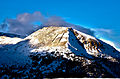
 East aspect | |
| Highest point | |
| Elevation | 12,705 ft (3,872 m)[1][2] |
| Prominence | 425 ft (130 m)[1] |
| Parent peak | Pettingell Peak (13,559 ft)[2][3] |
| Isolation | 1.24 mi (2.00 km)[1] |
| Coordinates | 39°42′36″N 105°52′43″W / 39.7099144°N 105.8785694°W[4] |
| Naming | |
| Etymology | Ellsworth Bethel |
| Geography | |
 Mount Bethel Location in Colorado  Mount Bethel Mount Bethel (the United States) | |
| Country | United States |
| State | class 2[2] |
Mount Bethel is a 12,705-foot (3,872 m) mountain summit in Clear Creek County, Colorado, United States.
Description
Mount Bethel is set two miles (3.2 km) east of the
Etymology
The mountain was originally called "Little Professor", in association with "Big Professor" which was the original name for Mount Sniktau on the opposite side of Clear Creek. The mountain's toponym was officially adopted in 1926 by the United States Board on Geographic Names to remember Ellsworth Bethel (1863–1925), American botanist.[4] Bethel worked for the National Forest Service as a forest pathologist; he was a biology teacher at East Denver High School in Denver; and he named many of the peaks in Colorado's Indian Peaks Wilderness.
Climate
According to the Köppen climate classification system, Mount Bethel is located in an alpine subarctic climate zone with cold, snowy winters, and cool to warm summers.[6] Due to its altitude, it receives precipitation all year, as snow in winter, and as thunderstorms in summer, with a dry period in late spring. This climate supports the Loveland Ski Area two miles south of the peak.
See also
Gallery
-
 South aspect of Mount Bethel showing snow fences high on its slope
 -
 Mt. Bethel, with parent Pettingell Peak to right
 -
 Mount Bethel


.jpg)
References
- ^ a b c d "Mount Bethel, Colorado". Peakbagger.com. Retrieved April 9, 2023.
- ^ a b c "Bethel, Mount - 12,705' CO". listsofjohn.com. Retrieved April 9, 2023.
- ^ "Mount Bethel, Peakvisor.com". Retrieved April 9, 2023.
- ^ a b "Mount Bethel". Geographic Names Information System. United States Geological Survey, United States Department of the Interior. Retrieved April 9, 2023.
- ISBN 9780899978123, p. 74
- ISSN 1027-5606.
External links
- Mount Bethel: weather forecast
- Ellsworth Bethel: biography and photo
Places adjacent to Mount Bethel (Colorado) | ||||||||||||||||
|---|---|---|---|---|---|---|---|---|---|---|---|---|---|---|---|---|
| ||||||||||||||||