
Mount Holmes
| Mount Holmes | |
|---|---|
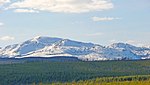
.jpg) Morning light on Trilobite Point and Mt. Holmes | |
| Highest point | |
| Elevation | 10,336 ft (3,150 m) NAVD 88[1] |
| Coordinates | 44°49′08″N 110°51′21″W / 44.81889°N 110.85583°W[2] |
| Geography | |
| Location | Yellowstone National Park, Park County, Wyoming, U.S. |
| Parent range | Gallatin Range |
| Topo map | Mount Holmes |
| Climbing | |
| Easiest route | Hike |
Mount Holmes is a prominent mountain peak in Yellowstone National Park. It is the tallest mountain in the Wyoming portion of the Gallatin Range. Mount Holmes is located in the northwestern part of the park and marks the southern terminus of the Gallatin Range. It is the source of Indian Creek, a tributary of the Gardner River.
There was a historic fire watch tower near the top of Mount Holmes, before it was burned due to a lightning strike.[3] The Bannock Trail crosses the mountains close to Mount Holmes.
History
An 1860 map by Captain
William H. Holmes, members of the third Hayden Geologic Survey, ascended the peak. Gannett named the peak Mount Holmes.[4]
The summit of Mount Holmes can be reached via the 10.8 miles (17.4 km) Mount Holmes-Winter Creek trail. The trailhead is located near Apollonaris Spring on the Mammoth-Norris section of the
Grand Loop Road.[5]
Images of Mount Holmes
-
 Mount Holmes' namesake,William H. Holmes
 -
 Mount Holmes as seen from Winter Creek, 1890
 -
 Mount Holmes and other peaks, 1963
 -
 Looking east from summit of Mount Holmes, 1965
 -
 2009
2009 -
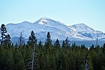 Mount Holmes (center) from Madison River, October 2010


See also
- Mountains and mountain ranges of Yellowstone National Park
- Mount Holmes (Utah)
Notes
- ^ "Mount Holmes, Wyoming". Peakbagger.com. Retrieved 2013-01-19.
- ^ "Mount Holmes". Geographic Names Information System. United States Geological Survey, United States Department of the Interior.
- ^ "Historic Mount Holmes Fire Lookout in Yellowstone Park burns down after lightning strike". KTVQ.com. 2019-07-17. Retrieved 2019-07-18.
- ISBN 0-917298-15-2.
- ISBN 0-7627-2539-7.
Yellowstone National Park - Norris and Madison | ||
|---|---|---|
Geothermal features, historic structures and other attractions in the Norris and Madison Junction areas | ||
| Norris Geyser Basin |  | |
| Gibbon Geyser Basin | ||
| Structures and history |
| |
| Geography and geology | ||
| ||
Cheyenne (capital) | |
| Topics | |
| Society |
|
| Regions | |
| Cities | |
| Counties | |