
Noordhoek, Cape Town
Noordhoek | ||
|---|---|---|
PO box | 7979 | |
Noordhoek is a seaside town in the
Kommetjie. Near the southern end of this beach is the wreck of the steamship "Kakapo", which ran aground in 1900, when the captain mistook Chapman's Peak for the Cape of Good Hope and put the helm over to port.[2]
Noordhoek can be accessed either from the scenic coastal road
Chapman's Peak Drive, which leads out of Hout Bay or via the mountain road Ou Kaapse Weg which cuts through the Silvermine Nature Reserve - now part of the Table Mountain National Park. Noordhoek is a small scattered community of houses, often with sea views and has a large horse population as riding on the long sandy beach is common; the beach is a 6 km (3.7 mi) stretch of fine white sand backed by Chapman's Peak (592 m (1,942 ft)) and the Table Mountain National Park. Winds are often strong and the sea is cold and wild. The town consists of a riding stables and a scattering of villas in a wide grassy valley with oak trees. In the middle of this valley is the Noordhoek Farm Village, with craft shops, a children's playground, café, pub and restaurant.[3]
Transport
Roads
Noordhoek is accessed by two metropolitan routes within the Greater Cape Town metropolitan area, the M6 and M65.
The M6 links Noordhoek to Hout Bay and Cape Town in the north as ‘Noordhoek Main Road’ and Simon’s Town in the south-east as ‘Glencairn Expressway’ and the M64, better known as ‘Ou Kaapse Weg’ links Noordhoek to Westlake and Cape Town (via the M3 freeway) through the Steenberg mountains.
Gallery
-
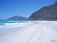 Looking north along the beach. The slopes of Chapman's Peak rise to the right at the end of the sand. The peak in the distance is Karbonkelberg, west of Hout Bay
 -
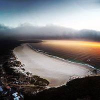 An evening flight over Noordhoek Beach, with Kommetjie in the distance.


References
- ^ a b c d "Main Place Noordhoek". Census 2011.
- ISBN 0-86977-387-9.
- ISBN 978-0-241-20004-9.