
Ontario Highway 64
| ||||
|---|---|---|---|---|
| North end | ||||
| Location | ||||
| Country | Canada | |||
| Province | Ontario | |||
| Highway system | ||||
| ||||
King's Highway 64, commonly referred to as Highway 64, is a
Highway 64 was first assumed in 1937, the year that the Ontario
Route description
The southern terminus of Highway 64 is an interchange with Highway 69 in
The highway travels east for approximately 26 kilometres (16 mi), where it intersects with
Highway 64 continues, alternating in northward and eastward segments around the west arm of
The
-
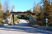 Highway 64 at Field
 -
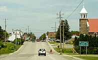 Highway 64 at Noëlville


History
The Sturgeon Falls Road was first assumed by the DHO as Highway 64 on August 25, 1937, shortly after the merger with the DND. The route was 53.6 kilometres (33.3 mi) long when it was first established, connecting Highway 11 and Highway 17.[1] As Highway 69 did not exist between Parry Sound and Sudbury until the 1950s, there was no need for a second highway connection through the French River area.[5] However, on January 25, 1956 the highway was extended south through Nipissing District, followed on February 8, 1956 with an extension through Sudbury District to the now-completed Highway 69.[6] This brought Highway 64 to its current length. Since then, aside from paving and minor realignments, Highway 64 has remained unchanged apart from the conversion of its junction with Highway 69 from a regular intersection to a freeway interchange. As part of the ongoing expansion of Highway 69 to a freeway, an interchange was constructed immediately south of the intersection between the two highways. It was completed on July 15, 2016, and opened to traffic shortly thereafter.[3]
Major intersections
The following table lists the major junctions along Highway 64, as noted by the Ministry of Transportation of Ontario.[2]
| Division | Location | km[2] | mi | Destinations | Notes |
|---|---|---|---|---|---|
Toronto | Interchange; future Highway 400 | ||||
| 5.1 | 3.2 | Highway 607 | |||
| 18.3 | 11.4 | Wolseley Bay | |||
Hagar | |||||
| French River | 43.5 | 27.0 | Muskrat Creek Bridge; Sudbury – Nipissing boundary | ||
| Nipissing | |||||
Sudbury | Beginning of Highway 17 concurrency | ||||
Sturgeon Falls | 87.1 | 54.1 | End of Highway 17 concurrency; beginning of Sturgeon Falls Connecting Link agreement | ||
| 89.5 | 55.6 | Sturgeon Falls town limits; end of Connecting Link agreement | |||
Highway 575 | |||||
| 110.4 | 68.6 | Highway 539 | |||
| Marten River | 145.0 | 90.1 | |||
1.000 mi = 1.609 km; 1.000 km = 0.621 mi
| |||||
References
- ^ a b "Appendix No. 3 - Schedule of Assumptions and Reversions of Sections of the King's Highway System for the Year Ending March 31, 1938". Annual Report (Report). Department of Highways. March 31, 1938. p. 80. Retrieved February 3, 2021 – via Internet Archive.
- ^ a b c Ministry of Transportation of Ontario (2016). "Annual Average Daily Traffic (AADT) counts". Retrieved January 1, 2021.
- ^ a b MacDonald, Darren (July 15, 2016). "Thibeault Announces Completion of Highway 69 Widening". Sudbury.com. Retrieved February 18, 2021.
- ^ ISBN 978-1-55198-226-7.
- ^ Ontario Road Map (Map). Cartography by C.P. Robins. Ontario Department of Highways. 1949. § N31–O32.
- ^ "Appendix 3 - Schedule of Assumptions of Sections". Annual Report (Report). Department of Highways. March 31, 1956. pp. 204–205.
External links
| |||||||||||||
| |||||||||||||
| |||||||||||||

