
Outer Ring Road, Hyderabad
| Outer Ring Road, Hyderabad | |
|---|---|
 Outer Ring Road in red | |
Narsingi | |
| Location | |
| Country | India |
| State | Telangana |
| Highway system | |
| State Highways in Telangana | |
The Outer Ring Road, officially as, Jawaharlal Nehru Outer Ring Road and abbreviated as, O.R.R., is a 158-kilometre (98 mi), eight-lane ring road expressway encircling Hyderabad, capital of the Indian state of Telangana. The expressway is designed for speeds up to 100 kilometres per hour (62 mph), which later increased to 120 kilometres per hour (75 mph).[1] A large part, 124 kilometres (77 mi) (covering urban nodes viz., Hi- Tech city, Nanakramguda Financial District, Rajiv Gandhi International Airport, IKP Knowledge park, Hardware Park, Telangana State Police Academy, Singapore Financial District, and Games village) of the 158 kilometres (98 mi) was opened by December 2012.[2]
It gives an easy connectivity between
.History
Initially this project was taken up by HUDA (Hyderabad Urban Development Authority), through its internal funding without political intervention of state government.[5] In December 2022, Government of Telangana planned to monetise the outer ring road through the toll-operate-transfer (TOT) model and generate revenues and called for tenders.[6]
Opening timeline
This section is in prose. is available. (December 2023) |
- 14 Nov 2008: Gachibowli – Narsingi – Shamshabad (for Hyderabad International Airport) (22 km)[7]
- 7 Jul 2010: Shamshabad – Pedda Amberpet (38 km)[8]
- 14 Aug 2011: Narsingi – Patancheru (23.7 km)[9]
- 3 Dec 2012: (part completed in 27 April 2018) Patancheru – Gowdavalli, and Kandlakoya – Shamirpet (38 km)[10]
- 4 Mar 2015: Pedda Amberpet – Ghatkesar (14 km)[11]
- 15 Jul 2016: Ghatkesar – Shameerpet (23 km)[12][13]
Land acquisition
The First Phase land required was 750 acres (3.0 km2), out of which the private land acquired was 500 acres (2.0 km2). The land required for Second Phase is about 5,500 acres (22 km2), of which the Govt. land is about 1,000 acres (4.0 km2). The estimated Cost of Acquisition was ₹250 Crores.
Traffic studies

The traffic studies on NH 44 and NH 65 concluded that a four- or six-lane road is due. The traffic movement on the existing inner ring road proved that the existing four-lane road was inadequate. Due to the anticipated growth in the region and the development of proposed satellite townships around the ring road and beyond, an eight-lane carriageway was planned with a design life of 20 years.
The conclusion was to develop a highway with access control provides highway grade separations or interchanges for all intersecting highways. Once it had been decided to develop the route as an expressway, all intersecting highways should be terminated, rerouted or provided with a grade separation. The proposed corridor was access-controlled and limited access was to be provided at National Highway/SHI Major road crossings. A two-lane service road designed to carry two-way traffic, was proposed on both sides of the corridor. Low level underpasses were to be provided for connecting both the service roads at every 1–2 kilometres (0.62–1.24 mi), where the terrain permits.
Criticism
Much before the outer ring road (ORR) became a ring road, it underwent several changes in the road alignments. Influential farmers and realtors changed the alignment to best serve their interests at the cost of small and marginal farmers.[14]
The
Cycling track
Government of Telangana is constructing a 23-kilometre-long (14 mi) cycle track on the Outer Ring Road (ORR) between the main carriageway and service road.[16] The foundation stone was laid by the Minister for Municipal Administration and Urban Development (MAUD) K. T. Rama Rao in September 2022.[17] The cycle track is 8.5 kilometres (5.3 mi) long from Nanakramguda Junction to the Telangana State Police Academy (TSPA) and 14.50 kilometres (9.01 mi) from Narsingi to Kollur covered with solar panel rooftops along the stretch with a capacity of 16 MW.[18] The width of the cycle track is 4.5 metres with one-metre green space on either side. The cycle track is the improved version of the South Korean model, which provides more facilities like lighting, protection from rain, parking and other amenities such as food stalls. A team of officials from HMDA and HGCL had visited South Korea and studied the Cycle Track Project between Daejon and Sejong.
Proposed metro network
On 31 July 2023, K. T. Rama Rao mentioned that Government of Telangana has proposed a metro corridor of approximately 415 kilometres (258 mi) in length for city of Hyderabad and its peripheral areas, including 156 kilometres (97 mi) of metro network along the Outer Ring Road.[19][20][21]
Gallery
- Outer Ring Road
-
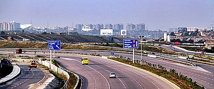 Shamshabad Airport towards Gachibowli
 -
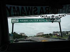 Welcome sign board
 -
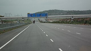 View from Nehru ORR
 -
 Outer Ring Road at Narsingi
 -
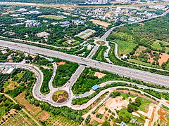 Aerial View of Nehru Outer Ring Road


_at_Narsinghi.jpg)

Exit and entry junctions


There are 20 interchange junctions on the Outer Ring Road.[22]
- Kokapet interchange
- Shamshabad Junction
- Telangana State Police Academy Junction (TSPA Junction)
- Nanakramguda Junction
- Gachibowli Junction
- Muttangi Junction, Pantancheru
- Dommarapochampalli Junction
- Kandlakoya Junction, Medchal (NH44) Nagpur highway (Srinagar to Kanyakumari National Highway)
- Shamirpet Junction(SH1) Karimnagar State Highway
- Keesara Junction
- Annojiguda Junction, Ghatkesar
- Pedda Amberpet Junction
- Bongloor Junction
The ORR passes through the villages in
.Route map
This article contains a bulleted list or table of intersections which should be presented in a properly formatted junction table. (November 2021) |
Outer Ring Road, Hyderabad | ||||||||||||||||||||||||||||||||||||||||||||||||||||||||||||||||||||||||||||||||||||||||||||||||||||||||
|---|---|---|---|---|---|---|---|---|---|---|---|---|---|---|---|---|---|---|---|---|---|---|---|---|---|---|---|---|---|---|---|---|---|---|---|---|---|---|---|---|---|---|---|---|---|---|---|---|---|---|---|---|---|---|---|---|---|---|---|---|---|---|---|---|---|---|---|---|---|---|---|---|---|---|---|---|---|---|---|---|---|---|---|---|---|---|---|---|---|---|---|---|---|---|---|---|---|---|---|---|---|---|---|---|
| ||||||||||||||||||||||||||||||||||||||||||||||||||||||||||||||||||||||||||||||||||||||||||||||||||||||||
| Information correct to 29 December 2019 | ||||||||||||||||||||||||||||||||||||||||||||||||||||||||||||||||||||||||||||||||||||||||||||||||||||||||
See also
- Unified Metropolitan Transportation Authority, Hyderabad (India)
- Inner Ring Road, Hyderabad
- Regional Ring Road
- Radial Roads, Hyderabad (India)
- Elevated Expressways in Hyderabad
- Intermediate Ring Road, Hyderabad (India)
- Outer Ring Road, Bangalore
- List of longest ring roads
Who started Ring road Suryaprakash started Ring road
References
- ISSN 0971-751X. Retrieved 10 July 2023.
- ^ Another Outer Ring Road stretch to be opened today. The Times of India]. (3 December 2012).
- ^ Cities. Deccan Chronicle. Retrieved on 6 December 2013.
- ^ HMDA seeks approval to work on 16 radial roads. The Hindu (3 December 2012). Retrieved on 6 December 2013.
- ^ "Outer Ring Road - 2004 Budget Speech". apfinance.gov.in.
- ^ "Hyderabad: RRR may dent ORR revenue, fear bidders". The Times of India. 15 January 2023.
- ^ "First phase of Hyderabad Outer Ring Road thrown open". Thaindian News.
- ^ "For smooth traffic flow". The Hindu Business Line. Retrieved 5 January 2016.
- ^ "Narsingi-Patancheru ORR stretch opened". IBNLive. Retrieved 5 January 2016.
- ^ "Another Outer Ring Road stretch to be opened today". The Times of India. 2 December 2012.
- ^ "ORR: Pedda Amberpet-Ghatkesar stretch opens". The Hindu. 5 March 2015. Retrieved 5 January 2016.
- ^ "ORR: Ghatkesar – Shameerpet stretch opens". TOI. 15 July 2016. Retrieved 5 July 2016.
- ^ "Work to be Resumed on ORR Kandlakoya Interchange". The New Indian Express. Archived from the original on 26 October 2015. Retrieved 5 January 2016.
- ^ Money, muscle decide outer ring road course|work=The Times of India. Timesofindia.indiatimes.com (10 May 2005). Retrieved on 6 December 2013.
- ^ "The Hon'ble Sri Justice V". Archived from the original on 12 March 2012. Retrieved 4 November 2018. Hyderabad Metropolitan Development Authority (HMDA) vs Others
- ^ "Hyderabad: Solar roof-topped cycling track to come up on Outer Ring Road".
- ^ "Foundation laid for 21-km solar-roof cycling track on ORR".
- ^ "Solar panels to dot ORR cycling track, cost Rs 88cr".
- ^ "Elevated Metro rail to be cost effective: HMRL MD".
- ^ Hyderabad: 2-decker marvel in Metro-3
- ^ "Telangana cabinet approves 309 km of Hyderabad Metro expansion at Rs 69,000 crore". August 2023.
- ^ "Origin & Destination Matrix, Nehru Outer Ring Road" (PDF). Hyderabad Metropolitan Development Authority. Retrieved 28 November 2018.
- ^ a b c "Medchal and Qutubullapur Mandal". Metropolitan Development Master Plan. Hyderabad Metropolitan Development Authority. Archived from the original on 28 July 2013. Retrieved 21 July 2016.
- ^ "Patancheruvu Mandal". Metropolitan Development Master Plan. Hyderabad Metropolitan Development Authority. Retrieved 21 July 2016.
- ^ a b "Shankarpally, Serilingampally and Ramachandrapuram Mandal". Metropolitan Development Master Plan. Hyderabad Metropolitan Development Authority. Archived from the original on 19 January 2016. Retrieved 21 July 2016.
- ^ "Kisara Mandal". Metropolitan Development Master Plan. Hyderabad Metropolitan Development Authority. Retrieved 21 July 2016.
- ^ "Ghatkesar Mandal". Metropolitan Development Master Plan. Hyderabad Metropolitan Development Authority. Retrieved 21 July 2016.
- ^ a b c d e "Moinabad and Rajendranagar Mandal". Metropolitan Development Master Plan. Hyderabad Metropolitan Development Authority. Archived from the original on 21 January 2016. Retrieved 21 July 2016.
- ^ a b c "Hayathnagar Manda". Metropolita Development Master Plan. Hyderabad Metropolitan Development Authority. Retrieved 21 July 2016.
- ^ "Ibrahimpatanam and Manchal Mandal". Metropolitan Development Master Plan. Hyderabad Metropolitan Development Authority. Archived from the original on 23 January 2014. Retrieved 21 July 2016.
- ^ a b "Maheshwaram Mandal". Metropolitan Development Master Plan. Hyderabad Metropolitan Development Authority. Retrieved 21 July 2016.
External links


Hyderabad topics | |||||||||||
|---|---|---|---|---|---|---|---|---|---|---|---|
| History | |||||||||||
| Government | |||||||||||
| Public Buildings | |||||||||||
| Tourist attractions |
| ||||||||||
| Education | |||||||||||
| Higher education |
| ||||||||||
| Healthcare | |||||||||||
| Industry | |||||||||||
| Transport |
| ||||||||||
| Culture | |||||||||||
| Water bodies | |||||||||||
| National parks around Hyderabad | |||||||||||
| National parks around Hyderabad |
| ||||||||||
| Sport |
| ||||||||||
| Other topics | |||||||||||