
Prenzlau
Prenzlau | |
|---|---|
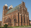
 Medieval town gate Mitteltor and St Mary Church | |
 Coat of arms | |
Location of Prenzlau within Uckermark district  | |
Ortsteile | |
| Government | |
| • Mayor (2017–25) | Hendrik Sommer[1] |
| Area | |
| • Total | 142.18 km2 (54.90 sq mi) |
| Elevation | 30 m (100 ft) |
| Population (2022-12-31)[2] | |
| • Total | 18,909 |
| • Density | 130/km2 (340/sq mi) |
| Time zone | UTC+01:00 (CET) |
| • Summer (DST) | UTC+02:00 (CEST) |
| Postal codes | 17291 |
| Dialling codes | 03984 |
| Vehicle registration | UM |
| Website | www.prenzlau.info |
Prenzlau (German: [ˈpʁɛnt͡slaʊ] ⓘ, formerly also Prenzlow) is a town in Brandenburg, Germany, the administrative seat of Uckermark District. It is also the centre of the historic Uckermark region.
Geography
The town is located on the
Prenzlau station—which opened in 1863—is a stop on the Angermünde–Stralsund railway
line.
History
Settled since
Dukes of Pomerania had the region colonized by Low German
settlers.
Prenzlau itself, named after
Slavic Premyslaw, was first mentioned in 1187. It received town privileges by Duke Barnim I of Pomerania in 1234. When Duke Barnim signed the Treaty of Landin with the Ascanian margraves of Brandenburg in 1250, Prenzlau was already a fortified town with walls and moats, four parish churches and a monastery. Together with Berlin-Cölln, Frankfurt and Stendal
, it ranked among the largest towns in the margraviate.
The Prenzlau and the Uckermark region were devastated during the
Huguenot refugees settled here and an economic recovery started. Also a garrison town, Prenzlau was again ravaged by passing troops during the Seven Years' War and the Napoleonic Wars. In the mid 19th century, several citizens emigrated to Australia, where they founded the town of Prenzlau, Queensland west of Brisbane
.
In
Plattenbau
buildings.
Demography
-
 Development of population since 1875 within the current Boundaries (Blue Line: Population; Dotted Line: Comparison to Population development in Brandenburg state; Grey Background: Time of Nazi Germany; Red Background: Time of communist East Germany)
 -
 Recent Population Development and Projections (Population Development before Census 2011 (blue line); Recent Population Development according to the Census in Germany in 2011 (blue bordered line); Official projections for 2005–2030 (yellow line); for 2017–2030 (scarlet line); for 2020–2030 (green line)


|
|
|
Climate
| Climate data for Prenzlau (Grünow, 1991–2020 normals) | |||||||||||||
|---|---|---|---|---|---|---|---|---|---|---|---|---|---|
| Month | Jan | Feb | Mar | Apr | May | Jun | Jul | Aug | Sep | Oct | Nov | Dec | Year |
| Mean daily maximum °C (°F) | 2.6 (36.7) |
3.6 (38.5) |
8.0 (46.4) |
14.2 (57.6) |
18.2 (64.8) |
21.8 (71.2) |
24.7 (76.5) |
24.4 (75.9) |
19.6 (67.3) |
13.3 (55.9) |
7.2 (45.0) |
3.6 (38.5) |
13.6 (56.5) |
| Daily mean °C (°F) | 0.4 (32.7) |
0.8 (33.4) |
3.8 (38.8) |
8.7 (47.7) |
13.0 (55.4) |
16.3 (61.3) |
18.8 (65.8) |
18.7 (65.7) |
14.7 (58.5) |
9.6 (49.3) |
4.9 (40.8) |
1.8 (35.2) |
9.5 (49.1) |
| Mean daily minimum °C (°F) | −2.1 (28.2) |
−2.1 (28.2) |
0.2 (32.4) |
3.4 (38.1) |
7.1 (44.8) |
10.8 (51.4) |
13.3 (55.9) |
13.4 (56.1) |
10.2 (50.4) |
6.2 (43.2) |
2.3 (36.1) |
−0.7 (30.7) |
5.2 (41.4) |
| Average precipitation mm (inches) | 32.2 (1.27) |
20.8 (0.82) |
28.8 (1.13) |
22.5 (0.89) |
44.1 (1.74) |
61.4 (2.42) |
72.2 (2.84) |
54.2 (2.13) |
41.3 (1.63) |
35.9 (1.41) |
33.6 (1.32) |
27.7 (1.09) |
489.3 (19.26) |
| Average precipitation days (≥ 1.0 mm) | 15.2 | 12.5 | 12.3 | 10.3 | 12.6 | 12.6 | 13.6 | 13.2 | 11.5 | 13.9 | 13.9 | 16.4 | 160.7 |
| Average relative humidity (%)
|
87.7 | 84.2 | 79.4 | 71.9 | 72.7 | 73.4 | 70.8 | 70.2 | 76.2 | 84.6 | 89.9 | 89.4 | 79.2 |
| Mean monthly sunshine hours | 47.3 | 72.6 | 134.4 | 216.1 | 241.7 | 240.7 | 228.4 | 218.4 | 172.6 | 112.8 | 50.9 | 34.4 | 1,813.1 |
| Source: World Meteorological Organization[4] | |||||||||||||
Politics
Seats in the town's assembly (Stadtverordnetenversammlung) as of 2014 local elections:
- Christian Democratic Union (CDU): 7
- Social Democratic Party of Germany (SPD): 7
- The Left: 6
- Bürgerfraktion (Independent): 4
- Wir Prenzlauer (Independent): 2
- Free Democratic Party (FDP): 1
- National Democratic Party of Germany (NPD): 1
Twin towns – sister cities
 Barlinek, Poland
 Pokhvistnevo, Russia
 Uster, Switzerland
 Varėna, Lithuania
Notable people
.jpg)
- René Bielke (born 1962), ice hockey player
- Oscar Florianus Bluemner (1867–1938), American painter
- Wilhelm Grabow (1802–1874), civil servant, judge, and politician
- Jacob Philipp Hackert (1737–1807), landscape painter
- Frederika Louisa of Hesse-Darmstadt(1751–1805), queen consort of Prussia
- Louis I, Grand Duke of Hesse (1753–1830)
- Princess Amalie of Hesse-Darmstadt (1754–1832)
- Princess Wilhelmina Louisa of Hesse-Darmstadt(1755–1776)
- Paul Hirsch (1868–1940), politician
- Hans Felix Husadel (1897–1964), composer and conductor
- Otto Kaiser (1924 - 2017), scholar
- Brigitte Rohde (born 1954), sprinter
- Max von Schenckendorff (1875-1943), general in the Wehrmacht of Nazi Germany
- Ernst Christian Friedrich Schering (1824–1889), apothecary and industrialist
- Johannes Schmidt (1843–1901), linguist
- Christian Friedrich Schwan (1733–1815), publisher and bookseller
- Adolf Wilhelm Theodor Stahr(1805–1876), writer and literary historian
- Christiane Wartenberg (born 1956), athlete
- Carola Zirzow (born 1954), sprint canoer
Gallery
-
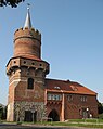 Gate Tower of the Brick Gothic 'Mitteltor'
 -
 War memorial ruin of the Holy Spirit Church
 -
-
 Old town hall
 -
 Historical painting of the Dedelow Castle
 -
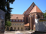 Dominican abbey
 -
 Unterucker Lake
 -
 Ucker canal watergate
 -
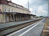 Platform of the train station
 -
 Martin Luther memorial
 -
 Medieval town wall, gate tower


References
- ^ Landkreis Uckermark Wahl der Bürgermeisterin / des Bürgermeisters, accessed 4 July 2021.
- Amt für Statistik Berlin-Brandenburg(in German). June 2023.
- ^ Detailed data sources are to be found in the Wikimedia Commons.Population Projection Brandenburg at Wikimedia Commons
- ^ "World Meteorological Organization Climate Normals for 1991–2020". World Meteorological Organization Climatological Standard Normals (1991–2020). National Oceanic and Atmospheric Administration. Archived from the original on 12 October 2023. Retrieved 13 October 2023.
- ^ "Partnerstädte". prenzlau.eu (in German). Prenzlau. Retrieved 2021-03-11.
External links
Wikimedia Commons has media related to Prenzlau.
- Municipal website (in German)
Towns and municipalities in Uckermark | ||
|---|---|---|
|  | |
| International | |
|---|---|
| National | |
| Geographic | |