
Auraiya district
Auraiya district | |
|---|---|
| Area | |
| • Total | 2,054 km2 (793 sq mi) |
| Population (2011)[1] | |
| • Total | 1,379,545 |
| • Density | 670/km2 (1,700/sq mi) |
| • Urban | 234,205 |
| Demographics | |
| • Literacy | 80.25% |
| • Sex ratio | 864 |
| Time zone | UTC+05:30 (IST) |
| Major highways | NH-19, Bundelkhand Expressway |
| Average annual precipitation | 792 mm |
| Website | auraiya |
Auraiya district is one of the
It lies on the south-western portion of Uttar Pradesh and also forms a part of the Kanpur Division.History

On 17 September 1997 two tehsils named Auraiya and
Modern History
Under the
The occupation, however, was merely nominal at first; the zamindars refused to pay revenue to Inayat Khan and, secure in their mud forts set his authority at defiance. Strong reinforcements were sent to the Rohillas, including some artillery, under Sheikh Kuber and Mullah Baz Khan, and many of the smaller forts were levelled to the grounds; but in their ravine fortresses the zamindars of Kamait in the trans-Yamuna tract still resisted the authority of Inayat Khan. Hafiz Rahmat and Inayat Khan then came in person to Etawah and operations were vigorously pressed against the refractory zamindars. Ultimately an annual tribute was agreed to by the latter. Hafiz Rahmat then departed to
In 1766 the Marathas under Mulhar Rao, who had been awaiting their opportunity, once more crossed the Yamuna and attacked Phaphund, where a Rohilla force under Muhammad Hasan Khan eldest son of Mohsin Khan, was posted. On receipt of this news Hafiz Rahmat advanced from Bareilly to oppose the Marathas. He was joined near Phaphund by Sheikh Kuber, the Rohilla governor of Etawah, and prepared to give battle; but Mulhar Rao refused to risk an engagement and once more retired across the Yamuna. The ambitions Najib-ud-daula had been considerably irritated by the intervention of the Rohillas on behalf of Ahmad Khan Bangladesh in 1762; and though he had been too busily engaged otherwise to pursue his plans of revenge before, he began in 1770 to plot the downfall of Hafiz Rahmat Khan.
Accordingly, a Maratha army was invited to Delhi for the purpose of first wresting Farrukhabad from Ahmad Khan and of afterwards invading Rohillakhand. The united forces of Najib-ud-daula and the Marathas advanced from Delhi; but at Koil Najib-ud-daula fell ill and retraced his steps, leaving his eldest son, Zabita Khan to operate with the Marathas. Zabita Khan however, was by no means disposed to fight against his brother Afghans. The Marathas, knowing this, kept him practically a prisoner in their camp and he requested Hafiz Rahmat Khan to obtain his release. Hafiz Rahmat Khan accordingly opened negotiations with the Marathas for the release of Zabita Khan; but the Maratha leaders demanded as their price the surrender of the jagirs of Etawah and Shikohabad. Hafiz Rahmat Khan was not disposed to agree to those terms, and while negotiations were proceeding for buying off the Marathas Zabita Khan escaped. Several desultory engagements now took place between the Marathas and the Afghan forces. Inayat khan was summoned by his father to Farrukhabad in order that he might be consulted regarding the surrendering of his jagirs. But although Dhunde Khan agreed to give up Shikohabad Inayat Khan refused to surrender Etawah.
Ultimately, disgusted with his father's arrangements he returned to Bareilly, and his father on his own responsibility sent orders to Sheikh Kuber, the Rohilla governor of Etawah, to surrender the fort to the Marathas. The Marathas now marched to Etawah, but as the orders had not yet reached him Sheikh Kuber gave them battle. Several desperate assaults were made on the fort of Etawah which were all beaten off, but finally it was handed over to the Marathas in accordance with hafiz Rahmat Khan's orders, and the Rohillas quit the district, leaving it once more in the hands of the Marathas. Later in the same year, 1771 AD, the Marathas advanced to Delhi and reinstated the emperor Shah Alam, who had cast in his lot with them, on the throne. They were now masters of the empire and Zabita Khan determined to oppose them. Assembling his forces, he attacked the Marathas near Delhi but was signally defeated, and in 1772 the Marathas overran a large portion of Rohilkhand and captured Najafgarh, where Zabita Khan's family resided and his treasure lay.
Under the Government of
Shuja-ud-daula then returned to Oudh, but denied ever having promised to restore the bond. He next seduced many of the Afghan Rohillas from their allegiance to Hafiz Rahmat Khan, and then proceeded to eject the Maratha garrisons from Etawah and Shikohabad in spite of Rahmat Khan's remonstrance. He ever went further and called on Hafiz Rahmat Khan to discharge the balance of 35 lakhs due on the bond. This was only a pretext for provoking hostilities for which purpose the Nawab had already begun to assemble an army; and Hafiz Rahmat Khan having failed to pay up, the Nawab advanced to the Ganges. The last scene in the tangled history of the period closed with the defeat of Hafiz Rahmat Khan by Shuja-ud-daula who was aided by a
From 1774 to 1801 the district of Etawah remained under the government of Oudh. Little occurred to disturb it during this period and little is known regarding its history. For many years the administration of the district was in the hands of Mian Almas Ali Khan. Ails were stationed, we know, at Etawah,
Geography

The district of Auraiya lies in the south-western portion of
The Auraiya District covers an area of 2,054 km2 (793 sq mi), of which more than one-third is designated rural. The main rivers which flows through the district are Yamuna and Sengar. The total length of the Yamuna in the district is about 112 km. Auraiya lies entirely in the Indo-Gangetic Plain, but its physical features vary considerably and are determined by the rivers which cross it.[2]
Climate
The District features an atypical version of the
Temperatures in the district range from 3 to 46 °C, with May being the hottest and January being the coolest month. During the rainy season the relative humidity is generally high being over 70%. Thereafter the humidity decreases and by summer which is the driest part of the year the relative humidity in the afternoons become less than 30%.
Cultivable Land
The area of cultivable land in the district in 1990-91 was 141624 hectares. According to the 1990-91 agricultural survey, the total number of active cultivable lands remained to be 151838. Most of the cultivables are small. The count of cultivables less than 0.5 hectares remained to be 47.65%, and between 0.5 & 1.0 hectares the cultivables remained to be 23.76%, and 1.0 to 2.0, it were 17.33%, and 2.0 to 4.0 hectare cultivable land's percentage was 8.54%, and more than 4.0 it were 2.72%.
Civic Administration
As of 2012, Auraiya district comprises 2 tehsils (Auraiya and Bidhuna), 2 census towns, 7 statutory towns (Ajitmal, Bhagyanagar, Sahar, Bidhuna, Achalda, Erwakatra and Auraiya) and 841 villages. It also has its own
Smt. Neha Prakash,
Villages
Politics
Auraiya District comes partly under
In
- Auraiya- Ramesh Diwakar (BJP)
- Bidhuna- Vinay Shakya (BJP)
- Dibiyapur- Lakhan Singh Rajput (BJP).
Economy
Auraiya district is one of the backward districts in
Small Scale Industries
The Rice-mills and Dal-mills are working well there in Dibiyapur and Auraiya. Other than these mills some steel furniture and cement products
Dibiyapur is notable industrial town of this district which has installations of India's leading Public Sector Enterprises viz. 663 MW Combined cycle power plant of NTPC,[3] Petrochemical plant and Gas compressor station of GAIL.[4] The
Transport
Station.jpg)

Rail
District has 8 Railway Station/Halt. The district is well served by its "A" graded Phaphund (Dibiyapur) railway station. Length of Railway Line in the district is 33 km and it comes under North Central Railway zone.
Road
Towns and villages are well equipped with a web of roads as it is the major way of transportation in the region. National Highway 19 (Mughal Road) pass from the southern part of the district. District's headquarters Auraiya is at 64 km distance from Etawah and 105 km from Kanpur. Auraiya Bus Station is situated on National Highway 19.
Demographics
| Year | Pop. | ±% p.a. |
|---|---|---|
| 1901 | 365,919 | — |
| 1911 | 344,748 | −0.59% |
| 1921 | 332,689 | −0.36% |
| 1931 | 338,346 | +0.17% |
| 1941 | 400,599 | +1.70% |
| 1951 | 440,253 | +0.95% |
| 1961 | 543,555 | +2.13% |
| 1971 | 669,181 | +2.10% |
| 1981 | 808,222 | +1.91% |
| 1991 | 1,000,035 | +2.15% |
| 2001 | 1,179,993 | +1.67% |
| 2011 | 1,379,545 | +1.57% |
| source:[5] | ||
According to the
Auraiya ranks 3rd in Literacy rate ranking of All U.P. districts ranking as per 2011 census
In 1991, Hindus percentage was 92.79% against the state average of 83.76% and 6.63% of
At the time of the
Culture
Dance & Music
Popular varieties of
A number of open air performances, combining the rural style of folk music and dancing with a central theme are a regular feature of rural life in the district. The dance named Banjasha is one of the most popular folk dances of villagers of the district. Nautankis and dramas based on mythology are often staged and attract large gatherings, particularly in the villages.
Festivals and Fairs
.Cuisine
A typical day-to-day traditional vegetarian meal of the district, like any other North Indian thali, consists of
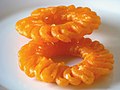
Sweets occupy an important place in the diet and are eaten at social ceremonies. People make distinctive sweetmeats from milk products, including khurchan,
-
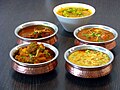 Different varieties of sabji
 -
 Dal Makhani, popular meal
 -
 North IndianThali
 -
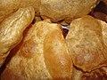 Puri on festivals
 -

-
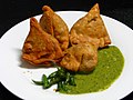 Samosa with chutney
 -

-


Dress
The people of Auraiya have colorful and different attires. The sari is the most favourite dress of ladies of all denominations, though women in shalwar kameez combinations are usually met with.
The men in village use to wear the traditional attires like kurtas, lungis, dhotis and pajamas. The colorless khadi (homespun cloth) jackets known as 'Nehru Jackets' are also popular. The Muslim women wear the traditional all enveloping 'burqa' and the men use to wear a round cap on their head.
Media
A number of newspapers and periodicals are published in Hindi, English, and Urdu. Amar Ujala, Dainik Bhaskar, and Dainik Jagran, have a wide circulation, with local editions published from several important cities. Major English language newspapers which are published and sold are The Times of India, Hindustan Times & The Hindu.
Multi system operators provide a mix of Hindi, English, Bengali, Nepali and international channels via cable. Cell phone providers include
Sports
Cricket and football are the most popular sports in the district. There are several cricket grounds, or maidans, located across the region.
References
- ^ a b c d e f g "District Census Handbook: Auraiya" (PDF). censusindia.gov.in. Registrar General and Census Commissioner of India. 2011.
- ^ a b c "Official Website of District Auraiya, Uttar Pradesh". Archived from the original on 6 September 2007. Retrieved 8 August 2010.
- ^ NTPC
- ^ GAIL
- ^ Decadal Variation In Population Since 1901
- ^ US Directorate of Intelligence. "Country Comparison:Population". Archived from the original on 27 September 2011. Retrieved 1 October 2011.
Swaziland 1,370,424
- ^ "2010 Resident Population Data". U. S. Census Bureau. Archived from the original on 19 October 2013. Retrieved 30 September 2011.
Hawaii 1,360,301
- ^ a b "Table C-01 Population by Religion: Uttar Pradesh". censusindia.gov.in. Registrar General and Census Commissioner of India. 2011.
- ^ a b "Table C-16 Population by Mother Tongue: Uttar Pradesh". www.censusindia.gov.in. Registrar General and Census Commissioner of India.
External links
Places adjacent to Auraiya district | ||||||||||||||||
|---|---|---|---|---|---|---|---|---|---|---|---|---|---|---|---|---|
| ||||||||||||||||
26°28′00″N 79°31′00″E / 26.4667°N 79.5167°E
| International | |
|---|---|
| National | |