
Badlands

Badlands are a type of dry terrain where softer
Badlands are found on every continent except Antarctica, being most common where there are
Badlands topography
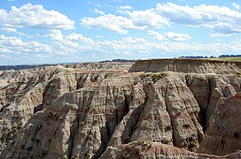
Badlands are characterized by a distinctive badlands topography.[3][4] This is terrain in which water erosion has cut a very large number of deep drainage channels, separated by short, steep ridges (interfluves).[5] Such a drainage system is said to have a very fine drainage texture,[6] as measured by its drainage density. Drainage density is defined as the total length of drainage channels per unit area of land surface. Badlands have a very high drainage density of 48 to 464 kilometres per square kilometre (77 to 747 miles per square mile).[5] The numerous deep drainage channels and high interfluves creates a stark landscape of hills, gullies, and ravines.[3]

In addition to a dense system of drainages and interfluves, badlands often contain buttes and hoodoos. These are formed by resistant beds of sandstone, which form the caprock of the buttes and hoodoos.[4]
Origin
Badlands arise from a combination of an impermeable but easily eroded ground surface, sparse vegetation, and infrequent but heavy rainfall.
In addition to surface erosion, badlands sometimes have well-developed piping, which is a system of pipes, joints, caverns, and other connected void spaces in the subsurface through which water can drain. However, this is not a universal feature of badlands. For example, the Henry Mountains badlands show very little piping.[2]
The precise processes by which the erosion responses take place vary depending on the precise interbedding of the sedimentary material.[7] However, it has been estimated that the badlands of Badlands National Park erode at the relatively high rate of about one inch or 25 millimetres per year.[8] The White River draining Badlands National Park was so named for its heavy load of bentonite clay eroded from the badlands.[4]
Regolith
Badlands are partially characterized by their thin to nonexistent regolith layers. The regolith profiles of badlands in arid climates are likely to resemble one another. In these regions, the upper layer (~1–5 cm or 0.4–2.0 in) is typically composed of silt, shale, and sand (a byproduct of the weathered shale). This layer can form either a compact crust or a looser, more irregular aggregation of "popcorn" fragments. Located beneath the top layer is a sublayer (~5–10 cm or 2.0–3.9 in), below which can be found a transitional shard layer (~10–40 cm or 3.9–15.7 in), formed largely of loose disaggregated shale chips, which in turn eventually gives way to a layer of unweathered shale. Badlands such as those found in the Mancos Shale, the Brule Formation, the Chadron Formation, and the Dinosaur Provincial Park can be generally said to fit this profile.[2]
In less arid regions, the regolith profile can vary considerably. Some badlands have no regolith layer whatsoever, capping instead in bare rock such as sandstone. Others have a regolith with a clay veneer, and still others have a biological crust of algae or lichens.[2]
In addition to lacking significant regolith, they also lack much vegetation. The lack of vegetation could very well be a result of the lack of a substantial regolith.[9]
Anthropogenic badlands

Although most badland topography is natural, badlands have been produced artificially by destruction of vegetation cover, through overgrazing, acid rain, or acid mine drainage.[5] The Cheltenham Badlands in Caledon, Ontario are an example of badlands produced by poor farming practices. In the early 1900s, the area was used for agricultural purposes, predominantly cattle grazing. Agricultural use ceased by 1931 and natural recovery of the majority of the property began.[10] Once established, however, this type of erosion can continue rapidly, if land clearing, over-grazing, and increased foot traffic by humans persists, as the shale is highly susceptible to erosion.[11]
An example of badlands created by mining is the Roman gold mine of Las Médulas in northern Spain.[citation needed]
Etymology
The word badlands is a calque from the Canadian French phrase les mauvaises terres, as the early French fur traders called the White River badlands les mauvaises terres à traverser or 'bad lands to traverse', perhaps influenced by the Lakota people who moved there in the late 1700s and who referred to the terrain as mako sica, meaning 'bad land' or 'eroded land'.[12]
The term
Human impact
Badlands are generally unsuitable for agriculture, but attempts have been made to remediate badlands. For example, reforestation is being attempted in the
Locations
Badlands are found on all the continents except Antarctica. The presence of unconsolidated sediments is a strong control on their locations.[17]
Argentina
The
Canada

The Cheltenham Badlands are in Caledon, Ontario, not far from Canada's largest city Toronto.[19]
The Big Muddy Badlands in Saskatchewan[20] gained notoriety as a hideout for outlaws.[21]
There is a large badland area in Alberta, particularly in the valley of the Red Deer River, where Dinosaur Provincial Park is located, as well as in Drumheller, where the Royal Tyrrell Museum of Palaeontology is located.[22]
China
.jpg)
Zhangye National Geopark is a badlands area known for its colorful rock formations. It was voted by Chinese media outlets as one of the most beautiful landforms in China and became a UNESCO Global Geopark in 2019.[23]
India
Garhbeta, Eastern India is a badlands located in a monsoon climate.[15] Chambal[24] spread across northern parts of Madhya Pradesh, southeastern Rajasthan and southern parts of Uttar Pradesh known for its lawlessness and dacoity is another example of badlands. A small strip of badlands is also found in western Uttar Pradesh and Haryana.
Italy

In Italy, badlands are called "calanchi". Some examples are Aliano (Basilicata), Crete Senesi (Tuscany) and Civita di Bagnoregio (Lazio).
New Zealand
A well-known badlands formation in
Spain

The
badlands.Turkey
Turkey has extensive badlands,
United States

In the U.S.,
Among the
Culture and media
Badlands have become a popular
Image gallery
-
-

-

-
 Badlands below North Caineville Plateau by theFremont River, Utah


See also
- Earth forest
- Tsingy de Bemaraha Strict Nature Reserve
- Calanque – Narrow, steep-walled inlet on the Mediterranean coast
- Death Valley – Valley in the Mojave Desert, Eastern California
References
- Chambers's Encyclopædia. London: George Newnes, 1961, Vol. 2, p. 47.
- ^ ISBN 978-1402057182
- ^ ISBN 0393924076.
- ^ ISBN 978-0470387740.
- ^ ISBN 0922152349.
- ^ ISBN 0471861979.
- ISBN 978-0470519097.
- ^ "Geologic Formations: How Badlands Buttes Came to Be". National Park Service. 10 November 2020.
- ^ Bryan, R. and A. Yair, 1982a. Perspectives on studies of badland geomorphology. In Badland geomorphology and piping. R. Bryan and A. Yair (eds), 1-3. Norwich: Geo Books.
- ^ "Cheltenham Badlands Management Planning Background Information" (PDF). Bruce Trail Conservancy. 2012. p. 4-5. Archived from the original (PDF) on 2021-05-21. Retrieved 2024-03-08.
- ^ Guillet, J.R (1977). Clay and Shale Deposits of Ontario, Ontario Geological Survey, Mineral Deposits Circular MDC15 (PDF).
- ^ Shaw, Ethan (2018-03-18). "How Did Badlands National Park Get Its Name?". USA Today. Retrieved 2019-08-01.
- ^ "Frequently asked questions". El Malpais National Monument. National Park Service. Retrieved 18 January 2021.
- ISBN 0922152349.
- ^ S2CID 232217656.
- .
- ^ S2CID 236762970.
- ^ "Ischigualasto / Talampaya Natural Parks". UNESCO World Heritage Centre.
- ISSN 0341-8162.
- ^ Harel, Claude-Jean (2006). "Big Muddy Valley". Encyclopedia of Saskatchewan. Great Plains Research Center. Archived from the original on 2009-06-19. Retrieved 2010-05-11.
- ^ Yanko, Dave. "Outlaw Rule". Virtual Saskatchewan. Retrieved 2010-05-11.
- ISBN 9780253345950.
- ^ "ZHANGYE UNESCO GLOBAL GEOPARK".
- ^ "28/07/2020". Empower IAS. Retrieved 2022-09-05.
- ^ "Putangirua Pinnacles Scenic Reserve". www.doc.govt.nz.
- ^ Lloyd Homer and Phil Moore, "Reading the Rocks: Aguide to the Geological Features of the Wairarapa Coast", Landscape Publications limited, 1989
- S2CID 233709481.
- ISBN 978-0-945695-11-0.
- JSTOR 24757762.
External links
- Badlands National Park (U.S. National Park Service)
- The Badlands: Nature's Time Capsule – Documentary about the badlands of South Dakota.
- . New International Encyclopedia. 1905.
| Authority control databases: National |
|---|