Chesapeake Bay impact crater
| Chesapeake Bay impact crater | |
|---|---|
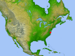
 Location of impact site in relation to North America | |
| Impact crater/structure | |
| Confidence | Confirmed |
| Diameter | 53 miles (85 km) |
| Depth | 0.81 miles (1.3 km) |
| Impactor diameter | 1.9 miles (3 km) |
| Age | 35.5 ± 0.3 million |
| Exposed | No |
| Drilled | Yes |
| Bolide type | L chondrite[1] |
| Location | |
| Location | Chesapeake Bay |
| Coordinates | 37°17′N 76°1′W / 37.283°N 76.017°W[2] |
| Country | United States |
| State | Virginia |
| Municipality | Cape Charles |
| Access | U.S. Route 13 to S.R. 184 |
The Chesapeake Bay impact crater is a buried impact crater, located beneath the mouth of Chesapeake Bay, United States. It was formed by a bolide that struck the eastern shore of North America about 35.5 ± 0.3 million years ago, in the late Eocene epoch. It is one of the best-preserved "wet-target" impact craters in the world.[3]
Continued slumping of sediments over the rubble of the crater has helped shape the Chesapeake Bay.
Formation and aftermath
During the warm late
The bolide made impact at a speed of approximately 17.8 kilometers per second (11.1 miles per second),
The entire circular crater is about 85 km (53 mi) in diameter and 1.3 km (1,300 m; 0.81 mi; 4,300 ft) deep, an area twice the size of Rhode Island, and nearly as deep as the Grand Canyon. However, numerical modeling techniques by Collins et al. indicate that the post-impact diameter was likely to have been around 40 km (25 mi), rather than the observed 85 km (53 mi).[4]
The surrounding region suffered massive devastation.
The impact has been identified as the source of the North American tektite field, namely the Georgiaite and Bediasite fields.[6]
Discovery

It was not until 1983 that evidence of a large impact crater was found, buried beneath the lower part of the Chesapeake Bay and its surrounding peninsulas. The first hint was an 8-inch-thick (20 cm) layer of ejecta found in a drilling core taken off Atlantic City, New Jersey, about 170 miles (274 km) to the north. The layer contained the fused glass beads called tektites and shocked quartz grains that are unmistakable signs of a bolide impact.
In 1993, data from oil exploration revealed the extent of the crater.[7]
Effects on local rivers
The continual
See also
- Toms Canyon structure probable impact crater 322 km (200 mi) to the northeast.
- Popigai impact structure of similar age
- Grande Coupure
- Carolina bays
References
- ISSN 0012-821X.
- ^ "Chesapeake Bay". Earth Impact Database. Planetary and Space Science Centre University of New Brunswick Fredericton. Retrieved 15 September 2019.
- ^ "Chesapeake Bay impact structure: Morphology, crater fill, and relevance for impact structures on Mars". USGS. United States Geological Survey. 2006. Retrieved 5 March 2019.
- ^ doi:10.1130/G21854.1.
- ^ Dell'Amore, Christine (2013-11-21). ""Mind-Blowing" Discovery: Oldest Body of Seawater Found in Giant Crater". National Geographic. National Geographic Society. Archived from the original on 2013-11-21. Retrieved 2015-07-01.
- S2CID 128672140.
- ISBN 978-3-642-62347-9. Archived from the originalon 9 October 2016. Retrieved 7 October 2016.
- S2CID 1735841.
Bibliography
- Poag, C. Wiley. Chesapeake Invader: Discovering America's Giant Meteorite Crater. Princeton, NJ: Princeton University Press, 1999. ISBN 0-691-00919-8
- Post-impact Effects of the Eocene Chesapeake Bay Impact, Lower York-James Peninsula, Virginia, 31st Annual Meeting, Virginia Geological Field Conference, Williamsburg, Virginia, Oct. 19 and 20, 2001, G.H. Johnson et al. (fieldtrip guidebook)
External links
- 'Isostatic Rebound and its effects on the Chesapeake Bay' Archived 2014-02-05 at the Wayback Machine
- A brief introduction to the Chesapeake Bay Impact Crater.
- USGS, 'Investigating the Chesapeake Bay Impact Crater.'
- USGS, 'The Chesapeake meteorite: message from the past.'
- 'The Chesapeake Bay bolide: modern consequences of an ancient cataclysm.'
- Earth Impact Database
- Satellite image of the region (from Google Maps)
- Chesapeake Bay Impact Structure Deep Drilling Project


