last glacial period, which ended about 10,000 years ago. (Full article...
)
Image 4
formations, all visible in Zion National Park in the U.S. state of Utah. Together, these formations represent about 150 million years of mostly Mesozoic-aged sedimentation in that part of North America. Part of a super-sequence of rock units called the Grand Staircase, the formations exposed in the Zion and Kolob area were deposited in several different environments that range from the warm shallow seas of the Kaibab and Moenkopi formations, streams and lakes of the Chinle, Moenave, and Kayenta formations to the large deserts of the Navajo and Temple Cap formations and dry near shore environments of the Carmel Formation.
Subsequent uplift of the Colorado Plateau slowly raised these formations much higher than where they were deposited. This steepened the stream gradient of the ancestral rivers and other streams on the plateau. The faster-moving streams took advantage of uplift-created joints in the rocks to remove all Cenozoic-aged formations and cut gorges into the plateaus. Zion Canyon was cut by the North Fork of the Virgin River in this way. Lava flows and cinder cones covered parts of the area during the later part of this process. (Full article...
outdated statistic] Io's volcanism makes the satellite one of only four known currently volcanically or cryovolcanically active worlds in the Solar System (the others being Earth, Saturn's moon Enceladus, and Neptune's moon Triton.)
First predicted shortly before the Voyager 1 flyby, the heat source for Io's volcanism comes from tidal heating produced by its forced orbital eccentricity. This differs from Earth's internal heating, which is derived primarily from radioactive isotope decay and primordial heat of accretion. Io's eccentric orbit leads to a slight difference in Jupiter's gravitational pull on the satellite between its closest and farthest points on its orbit, causing a varying tidal bulge. This variation in the shape of Io causes frictional heating in its interior. Without this tidal heating, Io might have been similar to the Moon, a world of similar size and mass, geologically dead and covered with numerous impact craters. (Full article...
the second largest confirmed impact structure on Earth, and the only one whose peak ring is intact and directly accessible for scientific research.
The crater was discovered by Antonio Camargo and Glen Penfield, geophysicists who had been looking for petroleum in the Yucatán Peninsula during the late 1970s. Penfield was initially unable to obtain evidence that the geological feature was a crater and gave up his search. Later, through contact with Alan R. Hildebrand in 1990, Penfield obtained samples that suggested it was an impact feature. Evidence for the crater's impact origin includes shocked quartz, a gravity anomaly, and tektites in surrounding areas. (Full article...
Mudpots lined up above a volcanic fissure at Hverarönd, Iceland
A mudpot, or mud pool, is a type of acidic hot spring, or fumarole, with limited water. It usually takes the form of a pool of bubbling mud, as a result of the acid and microorganisms decomposing surrounding rock into clay and mud. (Full article...)
contracting Earth hypothesis and together with Leopold Kober he worked on the geosyncline theory to explain orogeny. Stille's ideas emerged in the aftermath of Eduard Suess' book Das Antlitz der Erde (1883–1909). Stille's and Kober's school of thought was one of two that emerged in the post-Suess era the other being headed by Alfred Wegener and Émile Argand. This competing view rejected Earth contraction and argued for continental drift
. As Stille opposed continental drift he came to be labelled a "fixist".
... that Frederick Murray Trotter had a distinguished career as a field geologist despite losing a part of his skull and an eye to shrapnel during World War I?
the second largest confirmed impact structure on Earth, and the only one whose peak ring is intact and directly accessible for scientific research. (Full article...
)
Image 4
Animated, colour-coded map showing some continents and the region of Oceania (purple), which includes the continent of Australia. Depending on the convention and model, some continents may be consolidated or subdivided.
A continent is any of several large geographicalregions. Continents are generally identified by convention rather than any strict criteria. A continent could be a single landmass or a part of a very large landmass, as in the case of Asia or Europe. Due to this, the number of continents varies; up to seven or as few as four geographical regions are commonly regarded as continents. Most English-speaking countries recognize seven regions as continents. In order from largest to smallest in area, these seven regions are Asia, Africa, North America, South America, Antarctica, Europe, and Australia. Different variations with fewer continents merge some of these regions; examples of this are merging North America and South America into America, Asia and Europe into Eurasia, and Africa, Asia, and Europe into Afro-Eurasia. (Full article...)
Image 5
Superstructure of the Kola Superdeep Borehole, 2007
global climate that was synchronous with significant changes in Earth's biota both in the sea and on land. It occurred during the latter part of the Carnian Stage, a subdivision of the late Triassic period, and lasted for perhaps 1–2 million years (around 234–232 million years ago). (Full article...
The Mariana Trench is an oceanic trench located in the western Pacific Ocean, about 200 kilometres (124 mi) east of the Mariana Islands; it is the deepest oceanic trench on Earth. It is crescent-shaped and measures about 2,550 km (1,580 mi) in length and 69 km (43 mi) in width. The maximum known depth is 10,984 ± 25 metres (36,037 ± 82 ft; 6,006 ± 14 fathoms; 6.825 ± 0.016 mi) at the southern end of a small slot-shaped valley in its floor known as the Challenger Deep. The deepest point of the trench is more than 2 km (1.2 mi) farther from sea level than the peak of Mount Everest. (Full article...)
Cape Canaveral in November 2011 and landed on Aeolis Palus inside Gale on August 6, 2012, at 05:17 UTC. Curiosity's landing site, nicknamed Bradbury Landing, was less than 2.4 km (1.5 mi) from the center of the rover's touchdown target after a 560-million km (350-million mi) journey. The rover's goals include an investigation of the Martian climate and geology; assessment of whether the selected field site inside Gale has ever offered environmental conditions favorable for microbial life, including investigation of the role of water; as well as planetary habitability studies in preparation for human exploration.
This picture is a self-portrait of Curiosity on Mars at the "Big Sky" drilling site, where it collected a rock sample at the foothills of Aeolis Mons (Mount Sharp) in October 2015. The photograph combines dozens of images taken by the Mars Hand Lens Imager (MAHLI) camera at the end of the rover's robotic arm; the arm itself is not included, although its shadow is visible on the ground. Wrist motions and turret rotations on the arm allowed MAHLI to acquire the mosaic's component images.
A geological map of Yosemite National Park (full size), showing the Cathedral Peak Granodiorite, the largest unit in the Tuolumne Intrusive Suite, which in turn is the largest granitic suite in the park. Cathedral Peak Granodiorite Rest of the Tuolumne Intrusive Suite
The Lambert azimuthal equal-area projection is a projection used for mapping a sphere to a disk. It accurately represents area in all regions of the sphere, but it does not accurately represent angles. It is used in scientific disciplines such as geology for plotting the orientations of lines in three-dimensional space, and by the National Atlas of the US in its online map-making application.

 Image 1Colorado River, which in turn started to form the Grand Canyon. (Full article...)
 Vital articleVital articles to understand Geology.

 Featured biographyFeatured biography articles in Geology
 1941
1941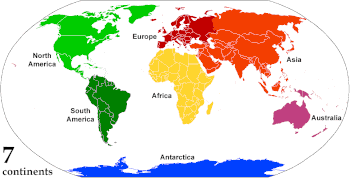
 Superstructure of the Kola Superdeep Borehole, 2007

 Geology portal
 Geology
 Geology
 CategoriesSelect [►] to view subcategories.
 Image 1Cape Canaveral in November 2011 and landed on Aeolis Palus inside Gale on August 6, 2012, at 05:17 UTC. Curiosity's landing site, nicknamed Bradbury Landing, was less than 2.4 km (1.5 mi) from the center of the rover's touchdown target after a 560-million km (350-million mi) journey. The rover's goals include an investigation of the Martian climate and geology; assessment of whether the selected field site inside Gale has ever offered environmental conditions favorable for microbial life, including investigation of the role of water; as well as planetary habitability studies in preparation for human exploration.
 Image 2unretouched surface of the moon.
 Image 3Map: Grandiose, based on a map by the United States Geological SurveyA geological map of Yosemite National Park (full size), showing the Cathedral Peak Granodiorite, the largest unit in the Tuolumne Intrusive Suite, which in turn is the largest granitic suite in the park.
 Image 4Map: Strebe, using GeocartThe Lambert azimuthal equal-area projection is a projection used for mapping a sphere to a disk. It accurately represents area in all regions of the sphere, but it does not accurately represent angles. It is used in scientific disciplines such as geology for plotting the orientations of lines in three-dimensional space, and by the National Atlas of the US in its online map-making application.
 Image 5geologic time. From most recent to oldest, age is indicated by color: yellow, green, blue, red.
 Commons
 Wikibooks
 Wikidata
 Wikinews
 Wikiquote
 Wikisource
 Wikiversity
 Wikivoyage
 Wiktionary


