
Chimney Rock (Colorado)
| Chimney Rock | |
|---|---|
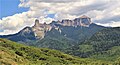
 South aspect | |
| Highest point | |
| Elevation | 11,781 ft (3,591 m)[1][2] |
| Prominence | 381 ft (116 m)[1] |
| Parent peak | Courthouse Mountain (12,152 ft)[3] |
| Isolation | 0.82 mi (1.32 km)[3] |
| Coordinates | 38°08′48″N 107°34′14″W / 38.1466593°N 107.5706149°W[4] |
| Naming | |
| Etymology | Chimney |
| Geography | |
 Chimney Rock Location in Colorado  Chimney Rock Chimney Rock (the United States) | |
| Location | South face |
Chimney Rock is an 11,781-foot-elevation (3,591-meter) pillar located on the shared boundary of
Climate
According to the Köppen climate classification system, Chimney Rock is located in an alpine subarctic climate zone with cold, snowy winters, and cool to warm summers.[7] Due to its altitude, it receives precipitation all year, as snow in winter, and as thunderstorms in summer, with a dry period in late spring. Precipitation runoff from the east side of the mountain drains into tributaries of the Cimarron River, and from the west side into Uncompahgre River via Cow Creek.
Films
Chimney Rock appeared in Rooster Cogburn's climactic shootout of the 1969 western motion picture, True Grit, starring John Wayne.[8] It is also seen in the 1962 epic, How the West Was Won, as Gregory Peck tries to tow a covered wagon stuck in the mud.[9]
Gallery
-
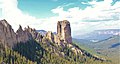
 Chimney Rock from the north, with Courthouse Mountain behind
 -
 Chimney Rock (left), Courthouse Mountain (right). West aspect.
 -

-
 Chimney Rock seen from Courthouse Trail
 -


See also
References
- ^ a b "Chimney Rock, Colorado". Peakbagger.com.
- ^ a b Lee Gregory, Colorado Scenic Guide: Southern Region, Third Edition, 1996, Johnson Books, page 108.
- ^ a b c "Chimney Rock - 11,781' CO". listsofjohn.com. Retrieved 2021-07-06.
- ^ a b c "Chimney Rock". Geographic Names Information System. United States Geological Survey, United States Department of the Interior. Retrieved 2021-07-06.
- ISBN 9780871089670
- ISBN 9781555661946, page 240.]
- ISSN 1027-5606.
- ISBN 9781476641270, page 215.
- ISBN 9781476642239, page 166.
External links
- Weather forecast: National Weather Service
- Chimney Rock and Courthouse Mountain photo: Flickr