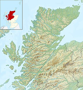
Creag Meagaidh
| Creag Mèagaidh | |
|---|---|
Glen Spean, Scotland | |
| Parent range | Grampian Mountains |
| OS grid | NN418875 |
| Topo map | OS Landranger 34, 42 |
| Name | Grid ref | Height | Status |
|---|---|---|---|
| Càrn Liath | NN472903 | 1,006 metres (3,301 ft) | Munro |
| Stob Poite Coire Ardair | NN428888 | 1,054 metres (3,458 ft) | Munro |
Creag Meagaidh (
The neighbouring peaks of Stob Poite Coire Ardair and Càrn Liath are sometimes called the Creag Meagaidh range. The Creag Meagaidh massif is part of Creag Meagaidh
Climbing
All three peaks in the range may be climbed from
These crags are a renowned venue for winter and ice climbing, although being somewhat vegetated they are less suited to summer climbing.[4]
In 2016 a person died in an avalanche on Creag Meagaidh and a second person was taken to hospital in a serious condition. [5]
Nature and conservation
Flora and fauna
| Creag Meagaidh National Nature Reserve | |
|---|---|
IUCN category IV (habitat/species management area)[6] | |
 An information board at Creag Meagaidh National Nature Reserve | |
| Location | Highland, Scotland |
| Coordinates | 56°57′06″N 4°36′10″W / 56.95162°N 4.60274°W |
| Area | 39.5 km2 (15.3 sq mi)[7] |
| Established | 1986[6] |
| Governing body | NatureScot |
| Creag Meagaidh National Nature Reserve | |
A number of nationally important plant species can be found at Creag Meagaidh, including
Over 150 species of invertebrates have been recorded on the summit plateau. This number include rarities such as the large wolf spider, which within Scotland is found only on one or two of the highest summits. One species of fly that has been identified at Creag Meagaidh, Spilogona trigonata, is not found anywhere else in Britain, being generally restricted to Scandinavia and North America.[11]
According to NatureScot, 137 different bird species have been recorded within the Reserve.
There are three species of deer found at Creag Meagaidh NNR:
Conservation designations
Creag Meagaidh has several overlapping conservation designations, testament to its diverse range of habitats and important features: it is a National Nature Reserve (NNR), a Site of Special Scientific Interest (SSSI), a Special Protection Area (SPA) and a Special Area of Conservation (SAC).[14] The Creag Meagaidh National Nature Reserve is classified as a Category IV protected area by the International Union for Conservation of Nature.[6]
History
The earliest historical records for Creag Meagaidh are from the seventeenth and early eighteenth centuries, when the area was farmed by tenants who grew crops on the lower slopes and grazed cattle on the higher ground during the summer. Following the
The first recorded ascent of Creag Meagaidh is thought to have been made in 1786 by Thomas Thornton, who described the view from the summit in his book, "Sporting Tour".[16]
By the early twentieth century the estate was being managed for sporting interests (
Gallery
-
Creag Meagaidh and the Coire Ardair seen from Càrn Liath
-
A closer view of the cliffs overlooking Coire Ardair
-
Another view of the cliffs
-
The north side of Creag Meagaidh
See also
References
- ^ "walkhighlands Creag Meagaidh". walkhighlands.co.uk. 2013. Retrieved 21 December 2013.
- ^ "Database - Creag Mèagaidh". Ainmean-Àite na h-Alba. Retrieved 7 February 2019.
- ^ ISBN 9780907521945.
- ISBN 0947782508.
- ^ "Climber who died after Scotland avalanche named by police". The Guardian. 19 February 2016. Archived from the original on 4 July 2022. Retrieved 4 July 2022.
- ^ a b c "Creag Meagaidh". Protected Planet. Retrieved 14 February 2021.
- ^ "Creag Meagaidh NNR". NatureScot. Retrieved 15 September 2020.
- ^ a b The Story of Creag Meagaidh National Nature Reserve. p. 10.
- ^ a b The Story of Creag Meagaidh National Nature Reserve. p. 11.
- ^ "Creag Meagaidh SSSI Citation". Scottish Natural Heritage. Retrieved 25 January 2019.
- ^ a b The Story of Creag Meagaidh National Nature Reserve. p. 13.
- ^ "Creag Meagaidh SPA". NatureScot. Retrieved 15 September 2020.
- ^ a b The Story of Creag Meagaidh National Nature Reserve. p. 12.
- ^ "Creag Meagaidh NNR - About the reserve". NatureScot. Retrieved 15 September 2020.
- ^ The Story of Creag Meagaidh National Nature Reserve. p. 15.
- ^ Ian R Mitchell, Scotland's Mountains Before the Mountaineers, p. 71-74. Published 2013, Luath Press.
- ^ The Story of Creag Meagaidh National Nature Reserve. p. 16.
Bibliography
- "The Story of Creag Meagaidh National Nature Reserve" (PDF). Scottish Natural Heritage. Archived from the original (PDF) on 12 August 2022. Retrieved 24 January 2019.


