
Trossachs
The Trossachs
| |
|---|---|
 The forested area at the eastern end of Loch Katrine | |
 The Trossachs Location within the Stirling council area | |
| OS grid reference | NN498068 |
| Council area | |
| Country | Scotland |
| Sovereign state | United Kingdom |
| Police | Scotland |
| Fire | Scottish |
| Ambulance | Scottish |
The Trossachs (
The wooded hills and lochs of the area may be considered to represent a microcosm of a typical highland landscape,[1] and the woodlands are an important habitat for many species.[2] Much of the Trossachs area is protected by various different conservation designations, including the Great Trossachs Forest National Nature Reserve.[3]
The Trossachs form part of the
Name and etymology
The name Trossachs involves the Brittonic root trōs meaning "across" (c.f. Welsh traws),[7][8] perhaps conserving the compound trawsfynydd meaning "cross-hill".[8]
Also suggested is a derivation from a Gaelic word for "bristly".[9][10]
Geography

The Trossachs glen lies between
The
The small town of Callander and the village of Aberfoyle lie at the edge of the Trossachs,[1] however Brig o' Turk is the only settlement of any size within the Trossachs.[11] The Lake of Menteith, situated near Aberfoyle, lies about six miles (10 km) to the south east of the glen, on the edge of the Trossachs area. The lake is a fishing destination that features the ruins of Inchmahome Priory on one of its islands, Inchmahome, where Mary, Queen of Scots was taken as a child before being taken to France for her protection.[12]
History
There are several
The Trossachs were one of the first parts of Scotland to become a recognised tourist destination due to the area's position on the southern edge of the
The scenic charms of the area came to popularity with
The leading
The Trossachs Hotel was built on the north bank of
Nature and conservation

The forests of the Trossachs comprise both areas of ancient, semi-natural and traditionally managed woodland alongside commercial forestry plantations. The native woodland is largely deciduous, whilst the commercial forestry consists mostly of conifers.
Fauna found in the woods of the Trossachs include
Species of fish found in the lochs of the Trossachs include
Much of the Trossachs area is protected via several different conservation designations.[3]
Great Trossachs Forest National Nature Reserve
The Great Trossachs Forest is a project that aims to deliver a 165 km2 forest in the heart of the Trossachs in order to develop a wide range of habitats for invertebrates, mammals, birds and other wildlife.
Other conservation designations
A smaller area (378 ha) of the Trossachs is protected as a Special Area of Conservation due to importance of the existing native forest.[25] The Trossachs are also defined as a national scenic area,[26] being one of 40 such areas in Scotland, which are defined so as to identify areas of exceptional scenery and to ensure its protection from inappropriate development.[27] Areas of forestry owned by Forestry and Land Scotland within the Trossachs form part of the Queen Elizabeth Forest Park,[28] and the entire area lies within the Loch Lomond and The Trossachs National Park.
Government and politics
The Trossachs area forms part of the council area of Stirling; at the most local level there is a Trossachs Community Council.[29]
The area is part of the
Hills and lochs

The chief hills of the Trossachs are:[1]
- Ben Venue (729 m)
- Ben A'an (454 m)
- Ben Ledi (879 m)
- Benvane (821 m)
- Ceann na Baintighearna (771 m)
- Stob a' Choin (865 m)

The major lochs in the area are:[9]
- Loch Katrine
- Loch Arklet
- Loch Achray
- Loch Venachar
- Loch Drunkie
- Loch Voil
- Loch Doine
- Loch Lubnaig
- Loch Chon
- Loch Dubh
- Loch Ard
Additionally, the Lake of Menteith may be regarded as lying on the boundaries of the district.[1]
Gallery
-
 A loch in the Trossachs
 -
![Engraving of a view of the Trossachs by James Fittler in Scotia Depicta, published 1804[33]](//upload.wikimedia.org/wikipedia/commons/thumb/a/a7/Scotia_Depicta_-_Trossacks_-Plate-.jpg/120px-Scotia_Depicta_-_Trossacks_-Plate-.jpg) Engraving of a view of the Trossachs by James Fittler in Scotia Depicta, published 1804[33]
Engraving of a view of the Trossachs by James Fittler in Scotia Depicta, published 1804[33] -
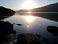 Early morning view of Loch Venachar

![Engraving of a view of the Trossachs by James Fittler in Scotia Depicta, published 1804[33]](/File:Scotia_Depicta_-_Trossacks_-Plate-.jpg)

References
- ^ a b c d e f g D. Bennet (ed.) The Southern Highlands. Scottish Mountaineering Club District Guides - Scottish Mountaineering Trust. 2nd edition (August 1986). pp. 47-49.
- ^ a b c d e "Strath Gartney, Achray and Loch Ard Forest: Special qualities of the Trossachs" (PDF). Loch Lomond and The Trossachs National Park Authority. 2006. pp. 130–131. Retrieved 20 June 2018.
- ^ a b "Sitelink - Map Search". NatureScot. Retrieved 16 September 2020.
- ^ "National park 'goes live'". BBC News. 8 July 2002.
- ^ "Loch Katrine - Loch Cruises". Steamship Sir Walter Scott Ltd. Retrieved 19 June 2018.
- ^ "What is the Great Trossachs Path". The Great Trossachs Forest. Retrieved 20 June 2018.
- ^ "Language Of The Landscape - What's In A Name?". Loch Lomond and the Trossachs. Retrieved 19 January 2019.
- ^ ISBN 9781906566357.
- ^ ISBN 0-09-463270-7
- ^ "History". Loch Catrine. Retrieved 19 January 2019.
- ^ a b c Ordnance Survey Landranger 1:50000. Sheet 57, Stirling & The Trossachs.
- ISBN 0-09-463270-7
- ^ "Recollections of a Tour Made in Scotland, 27 August 1803: The Trossachs". Undiscovered Scotland. Retrieved 19 June 2018.
- ^ Ruskin and Millais at Glenfinlas, The Burlington Magazine, Vol. 138, No. 1117, pages 228–234, April 1996. (Accessed via JSTOR, UK.)
- ^ Pre-Raphaelite Vision: Truth to Nature, Tate Britain, London, UK, 12 February – 3 May 2004.
- ^ "Tigh Mor Trossachs". Holiday Property Bond. Retrieved 19 June 2018.
- ^ "Loch Katrine - History". Steamship Sir Walter Scott Ltd. Retrieved 19 June 2018.
- ^ "SNH Research Report 1013 - Survey of the Tayside area beaver population 2017-2018" (PDF). Scottish Natural Heritage. 2018. p. iii. Retrieved 15 October 2018.
- ^ "Pearl Bordered Fritillary Butterfly". The Great Trossachs Forest. Retrieved 20 June 2018.
- ^ "The Great Trossachs Forest - Great Forest Restored". The Great Trossachs Forest. Retrieved 19 June 2018.
- ^ "The Great Trossachs Forest NNR". NatureScot. Retrieved 16 September 2020.
- ^ "Search Scotland's National Nature Reserves by A to Z". NatureScot. Retrieved 16 September 2020.
- ^ "The Great Trossachs Forest". Protected Planet. Retrieved 14 February 2021.
- ^ "The Great Trossachs Forest - Great Forest Wildlife". The Great Trossachs Forest. Retrieved 19 June 2018.
- ^ "Trossachs Woods SAC". NatureScot. Retrieved 16 September 2020.
- ^ "Trossachs NSA". NatureScot. Retrieved 16 September 2020.
- ^ "National Scenic Areas". NatureScot. Retrieved 16 September 2020.
- ^ "Queen Elizabeth Forest Park". Forest and Land Scotland. Retrieved 16 September 2020.
- ^ "Trossachs Community Council Area" (PDF). Stirling Council. 16 March 2008. Retrieved 21 June 2018.
- ^ "Land register counties and operational dates" (PDF). Registers of Scotland. 2016. Retrieved 21 June 2018.
- ^ "Stirling constituency map (Scottish Parliament)" (PDF). Boundaries Scotland. Retrieved 4 October 2022.
- Boundary Commission for Scotland. Retrieved 4 October 2022.
- ^ "Scotia Depicta, or the antiquities, castles, public buildings, noblemen and gentlemen's seats, cities, towns and picturesque scenery of Scotland". National Library of Scotland.
External links
- Loch Lomond and the Trossachs National Park
- Trossachs History and the people who contributed to it
- Loch Katrine in the Trossachs
- Places to visit at www.incallander.co.uk
| Authority control databases: National |
|---|