
Eastern Anatolia region
Eastern Anatolia Region
Doğu Anadolu Bölgesi | |
|---|---|
Region | |
 | |
| Country | Turkey |
| Area | |
• Total | 165,436 km2 (63,875 sq mi) |
| Population | |
• Total | 6,513,106 |
| • Density | 39/km2 (100/sq mi) |
| GDP | |
| • Total | US$ 28.582 billion (2022) |
| • Per capita | US$ 4,390 (2022) |
The Eastern Anatolia region (Turkish: Doğu Anadolu Bölgesi) is a geographical region of Turkey. The most populous province in the region is Van Province. Other populous provinces are Malatya, Erzurum and Elazığ.
It is bordered by the
in the east.
The region encompasses most of Western Armenia and had a large population of indigenous Armenians until the Armenian genocide. The Anatolia peninsula historically never encompassed what is now called "Eastern Anatolia" which was, instead, referred to as the Armenian highlands. It was renamed by the newly founded Turkish Republic in the 1920s.[2] This has been seen as an attempt by Turkey to erase the Armenian history of the region.[3][4]
It has the highest average altitude, largest geographical area, and lowest population density of the seven
Etymology

The English-language name Anatolia (Turkish: Anadolu) derives from the Greek Ἀνατολή (Anatolḗ) meaning "the East" and designating (from a Greek point of view) eastern regions in general.[7][8] Traditionally, Anatolia was considered to be a peninsula the eastern boundary of which was a line from the Black Sea to the Gulf of Alexandretta, which is to the west of what is now the Eastern Anatolia Region.[9][10] As a geographical term, this definition continues to be used.[11]
Historically, the region was referred to as the
The region encompasses most of Western Armenia (Armenian: Արեւմտյան Հայաստան) and had a large population of indigenous Armenians until the Armenian genocide. The Anatolia peninsula never encompassed what is now called "Eastern Anatolia", which has been seen as an attempt by Turkey to erase the Armenian history of the region.[4][12]
Subdivision
Eastern Anatolia Region has four subdivisions:
- Upper Euphrates division (Turkish: Yukarı Fırat Bölümü)
- Erzurum-Kars division (Turkish: Erzurum-Kars Bölümü)
- Upper Murat-Van division (Turkish: Yukarı Murat-Van Bölümü)
- Hakkari division (Turkish: Hakkari Bölümü)
Provinces
Provinces that are entirely in the Eastern Anatolia Region:
Provinces that are mostly in the Eastern Anatolia Region:
Location and borders
The Eastern Anatolia Region is located in the easternmost part of
The area of the region is 164,330 km2 (63,450 sq mi), which comprises 20.9% of the total area of Turkey.

Population
The total population of the region is 5,966,101 (2019 estimate), down from 6,100,000 at the 2000 census. The population density (40 inhabitants per square kilometre (100/sq mi)) is lower than the average for Turkey (98/km2 (250/sq mi)).[citation needed] The region has the second most rural population in Turkey after the Black Sea region. Migration, especially to Marmara Region, is high. Migration to other regions and abroad is higher than the natural population increase. Until the Armenian genocide, the region also had a large population of indigenous Armenians, when it was also known as Western Armenia, and in addition had significant minorities of Georgians, Pontic Greeks and Caucasus Greeks.[14][15][16]
Geography
The average altitude is 2,200 m (7,200 ft). Major geographic features include plains, plateaus and massifs. There is some volcanic activity today.
Lakes and rivers

- Located in the Eastern Anatolia Region Aras and Kura rivers flooded the shed outside the territory of Turkey to the Caspian Sea. Euphrates, the Tigris and the Zab river waters are poured back onto the Persian Gulf Turkey outside.
- The regime of the streams of the region is irregular. This is because; the irregularity of the precipitation regime and the fall of winter precipitation in the form of snow. As the snow falls on the ground for a long time without melting, the flow rates of the rivers decrease. The snow melting in spring and summer causes streams to increase their flow rates and flow enthusiastically. On the other hand, the rivers of the region have high hydroelectric energy potential. The reason for this is that it has high elevations and slopes.
- Lakes were formed on the fault lines throughout the region. Turkey's largest lake, Lake Van along with Lake Çıldır, Lake Nazik, Lake Erçek, Lake Hazar, Lake Balık, Lake Haçlı and Lake Akdoğan are located within the region.
Massifs and mountains
- There are three massif lines running north–south:
- To the north, the .
- In the centre, the Munzur, Karasu Dağı, Aras Dağı, Bingöl Mountains and Akdoğan mountains.
- To the south, Southeast Tauros; Karaçavuş Mountains, Bitlis, Hakkâri, and Buzul mountains.
- The volcanic mountains Tendürek and Araratare in the region.
Plateaus and plains
- The largest plateau in the region is Erzurum-Kars Plato.
- The region includes the Van Lake basin.
- The largest plain in the region is the
Lakes
Rivers
Climate and nature
| Erzurum | ||||||||||||||||||||||||||||||||||||||||||||||||||||||||||||
|---|---|---|---|---|---|---|---|---|---|---|---|---|---|---|---|---|---|---|---|---|---|---|---|---|---|---|---|---|---|---|---|---|---|---|---|---|---|---|---|---|---|---|---|---|---|---|---|---|---|---|---|---|---|---|---|---|---|---|---|---|
| Climate chart (explanation) | ||||||||||||||||||||||||||||||||||||||||||||||||||||||||||||
| ||||||||||||||||||||||||||||||||||||||||||||||||||||||||||||
| ||||||||||||||||||||||||||||||||||||||||||||||||||||||||||||
Since most of the region is far from the sea, and has high altitude, it has a harsh continental climate with long winters and short summers. During the winter, it is very cold and snowy, during summer the weather is cool in the highlands and warm in the lowlands.
The region's annual temperature difference is the highest in Turkey. Some areas in the region have different microclimates. As an example, Iğdır (near Mount Ararat) has a milder climate.
The region contains 11% percent of the total forested area of
The region has high potential for
Gallery
-
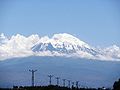 View of Mount Ararat (Ağrı in Turkish) from Iğdır
 -
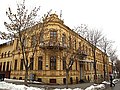
 Cumhuriyet Avenue in Erzurum
 -

-
 The 14th-centuryYakutiye Medresesi in Erzurum
 -
 Panoramic view of the city of Bingöl
 -
 The 10th-century Armenian Church of the Holy Apostles, with the Castle of Kars in the background
 -
 Kars city centre
 -
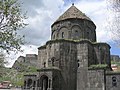
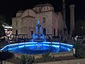
 Armenian Cathedral of the Holy Cross, a 10th-century Armenian churchand monastic complex
 -
 Ottoman era Yeni (New) Mosque in Malatya
 -


_(40336417982).jpg)


Endnotes
- ^ "Statistics by Theme > National Accounts > Regional Accounts". www.turkstat.gov.tr. Retrieved 11 May 2023.
- ISBN 978-0-19-067316-1.
- ISBN 978-0-8122-1616-5.
- ^ ISBN 978-1-84904-458-5.
As a result of policies such as these, the expression Armenian Plateau, which had been used for centuries to denote the mountainous highlands around Lake Van and Lake Sevan, was eliminated and replaced by the expression 'eastern Anatolia'.
- ^ ISBN 978-0-9699879-7-0.
- ^ ISBN 978-1-4128-3592-3.
- ^ Henry George Liddell; Robert Scott. "A Greek-English Lexicon". Archived from the original on 26 May 2007. Retrieved 20 February 2021.
- ^ "Anatolia | Origin and meaning of the name Anatolia by Online Etymology Dictionary". www.etymonline.com. Archived from the original on 13 July 2017. Retrieved 14 May 2021.
- ISBN 978-0-19-061047-0. Archivedfrom the original on 11 March 2020. Retrieved 7 December 2018.
- ISBN 978-0-87779-546-9. Archivedfrom the original on 28 November 2021. Retrieved 18 May 2001.
- ^ a b c d Journal of the Society for Armenian Studies. Vol. 14–16. Los Angeles. 2005. p. 55.
Most of historical Armenia presently constitutes a part of Turkey (renamed "Eastern Anatolia"), which conducts a policy of minimizing the role of the Armenians in history
{{cite book}}: CS1 maint: location missing publisher (link) - ISBN 978-1-86064-979-0.
- ISBN 978-3-319-69260-9.
- ISBN 978-1-349-27348-5.
- JSTOR 3600788.
Though no ethnicity comprised an absolute majority of the inhabitants of eastern Anatolia, Armenians formed a plurality, alongside Kurds.
- ^ "İRAP, Il afet risk azaltma planı" (PDF) (in Turkish). Disaster and Emergency Management Presidency. 2021. p. 18.
- ^ "İl ve İlçelerimize Ait İstatistiki Veriler- Meteoroloji Genel Müdürlüğü". Archived from the original on 2011-06-20. Retrieved 2011-05-31.
- ^ C, Aykut (2020-05-01). "Hidroelektrik Üretimi En Fazla Hangi Bölgede?". dpumekatronik.com (in Turkish). Retrieved 2020-10-08.
External links
| Authority control databases: National |
|---|