
Emi Koussi
| Emi Koussi | |
|---|---|
Ultra | |
| Coordinates | 19°47′33″N 18°32′47″E / 19.79250°N 18.54639°E[2] |
| Geography | |
 Emi Koussi Location in Chad | |
| Location | Chad |
| Parent range | Tibesti Mountains |
| Geology | |
| Age of rock | Holocene |
| Mountain type | Pyroclastic shield |
| Last eruption | unknown |
| Climbing | |
| Easiest route | Hike |
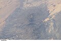
Emi Koussi (also known as Emi Koussou plains. The volcano is 60–70 kilometres (37–43 mi) wide and has a volume of 2,500 cubic kilometres (600 cu mi).
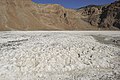
Two nested calderas cap the volcano, the outer one being about 15 by 11 kilometres (9.3 mi × 6.8 mi) in size. Within it on the southeast side is a smaller caldera known as Era Kohor, about 2 kilometres (1.2 mi) wide and 350 metres (1,150 ft) deep. Numerous lava domes, cinder cones, maars, and lava flows are found within the calderas and along the outer flanks of the shield. Era Kohor contains trona deposits, and Emi Koussi has been studied as an analogue of the Martian volcano Elysium Mons. Emi Koussi was active more than one million years ago, but some eruptions may be more recent, and there is ongoing fumarolic and hot spring activity.
Geography and geomorphology
Emi Koussi lies in
Emi Koussi rises to a height of 3,415 metres (11,204 ft) on the southern side of the volcano,[13][14] towering 3 kilometres (1.9 mi) above the surrounding terrain.[15] It is considered by some astronauts to be the most recognizable landmark on Earth, as seen from orbit.[15] Supposedly the entire Tibesti can be seen from the northern summits.[16]

It is a
Nested within this combined caldera is the Era Kohor caldera,
The Kohor
Geology
Tectonic activity appears to have occurred in the Tibesti already between the Carboniferous and the Cretaceous,[5] that is between 358.9 ± 0.4 and 66 million years ago.[28] During the earliest stage of volcanism on Tibesti, alkali basalts formed large plateaus. Later, the central volcanoes developed on top of these plateaus.[15] Volcanism in Tibesti has been explained with a mantle plume, as has been proposed for other African volcanoes,[29] although recently tectonic effects of the collision between Africa and Europe and their effects at a distance have also been advanced as an explanation.[30]
The oldest rocks below the Tibesti are Precambrian diorites, granites and schists,[27] which are probably of Neoproterozoic age and are differentiated into two units.[30] The volcanic rocks rest on an uplifted basement formed by Cretaceous[5] and Paleozoic sandstone.[15] The latter crop out at the southwestern foot of Emi Koussi, while volcanic rocks dominate north of the volcano, and the Tibesti massif is prevalent east and southeast of Emi Koussi.[27] Older volcanic rocks are exposed in valleys.[31]
Emi Koussi has erupted
During the early
Eruptive history

Emi Koussi erupted between 2.4 and 1.3 million years ago;[41] it is considered to be of Pliocene-Quaternary age.[42] The volcano was constructed mainly during the Miocene[17][43] within about one million years.[44] Radiometric dating has yielded ages of 2.42 ± 0.03 - 2.33 ± 0.09 million years ago for the oldest Emi Koussi stage. The third stage has yielded ages of 1.4 ± 0.3 - 1.32 ± 0.2 million years ago;[15][45] formerly Era Kohor was considered to be a Holocene centre.[24]
During the first stage, Emi Koussi erupted trachytes and trachyandesites in the form of ignimbrites and
Quaternary volcanism gave rise to the cones on the slopes of Emi Koussi,[18] and the three maars are the most recent vents in the combined caldera,[19] while long lava flows have been interpreted to be the youngest volcanism at Emi Koussi.[48] The most recent volcanic vents show little erosion.[47] Early in the Pleistocene, erosion took place on the flanks of Emi Koussi,[5] and carbonates were deposited in Era Kohor until recent times.[49][50]
On the southern foot of the volcano,
Climate and vegetation
The Tibesti mountains feature a desert mountain climate. There are no weather stations close to Emi Koussi and the stations at lower elevations likely underestimate precipitation at higher elevations,
A number of diatom species have been identified in sediments left by the Era Kohor lake, including
Generally, in the Tibesti vegetation occurs in five different belts depending on elevation.
The
Gallery
-
 Another view of it from space
 -
 Calderas of Emi Koussi
 -
 Emi Koussi inner crater
 -
 Natron in the inner caldera of Emi Koussi
 -
 Emi Koussi seen from Apollo 7 in October 1968


See also
- Geography of Chad
- List of volcanoes in Chad
- List of Ultras of Africa
References
- ^ a b c "Emi Koussi". Global Volcanism Program. Smithsonian Institution. Retrieved 3 November 2013.
- ^ "Emi Koussi". Peakbagger.com. Retrieved 2021-02-12.
- ^ Hellmich 1972, p. 10.
- ^ Gourgaud & Vincent 2004, p. 261.
- ^ a b c d e f g Malin 1977, p. 908.
- ^ a b Pachur & Altmann 2006, p. 88.
- ^ Gourgaud & Vincent 2004, p. 262.
- ^ Permenter & Oppenheimer 2007, p. 609.
- ^ a b Jäkel et al. 1972, p. 118.
- JSTOR 1789494.
- ^ a b c Pachur & Altmann 2006, p. 103.
- ^ a b Jäkel et al. 1972, p. 117.
- ^ a b c Gèze et al. 1959, p. 137.
- ^ a b Messerli & Winiger 1992, p. 327.
- ^ a b c d e f g h i j k Gourgaud & Vincent 2004, p. 264.
- ^ a b Tilho 1920, p. 172.
- ^ a b c Hellmich 1972, p. 21.
- ^ a b c d e f g Gourgaud & Vincent 2004, p. 263.
- ^ a b c d e f g h Gourgaud & Vincent 2004, p. 267.
- ^ JSTOR 23439749.
- ^ a b Permenter & Oppenheimer 2007, p. 621.
- ^ a b c Hellmich 1972, p. 172.
- ^ a b Jäkel et al. 1972, p. 119.
- ^ a b Malin 1977, p. 909.
- ^ a b Gèze et al. 1959, p. 139.
- ^ a b Poli 1974, p. 225.
- ^ a b c Permenter & Oppenheimer 2007, p. 616.
- ^ "International Chronostratigraphic Chart" (PDF). International Commission on Stratigraphy. August 2018. Archived from the original (PDF) on 31 July 2018. Retrieved 4 December 2018.
- ^ a b Gourgaud & Vincent 2004, p. 288.
- ^ a b Deniel et al. 2015, p. 3.
- ^ Gèze et al. 1959, p. 138.
- ^ Gourgaud & Vincent 2004, pp. 268–269.
- ISBN 9781468471281.
- ^ Pachur & Altmann 2006, p. 159.
- ^ a b Pachur & Altmann 2006, p. 119.
- ^ a b Hoelzmann, Philipp (2016-01-01). "Crater palaeolakes in the Tibesti mountains (Central Sahara, North Chad) – New insights into past Saharan climates". ResearchGate. EGU2016.
- ^ Hellmich 1972, p. 56.
- ^ Tilho 1920, p. 171.
- ^ a b Dumont 1987, p. 135.
- ^ Dumont 1987, p. 141.
- ^ Gourgaud & Vincent 2004, p. 266.
- ^ Gourgaud & Vincent 2004, p. 268.
- ^ Bruneau de Miré & Quézel 1959, p. 135.
- ^ Deniel et al. 2015, p. 17.
- ^ Deniel et al. 2015, p. 18.
- ^ Deniel et al. 2015, p. 8.
- ^ a b c Hellmich 1972, p. 22.
- ^
Oppenheimer, C. (1997). "Surveillance and Mapping of Volcanoes and their Emissions by Satellite Remote Sensing". Geography. 82 (4): 317–333. JSTOR 40572950.
- ^ a b Permenter & Oppenheimer 2007, p. 619.
- ^ Gèze et al. 1959, p. 165.
- ^ a b Dumont 1987, p. 134.
- ^ a b c "Hochgebirgsforschung: Tibesti - Zentrale Sahara, Arbeiten aus der Hochgebirgsregion". Zeitschrift für Gletscherkunde und Glazialgeologie. 8. 1972.
- ^ Messerli 1973, p. 146.
- ^ Messerli 1973, p. 141.
- ^ Messerli & Winiger 1992, p. 317.
- ^ Pachur & Altmann 2006, p. 137.
- ^ Pachur & Altmann 2006, p. 120.
- ^ Lézine et al. 2011, p. 1353.
- ^ Messerli 1973, p. 142.
- ^ Lézine et al. 2011, p. 1354.
- ^ ISSN 1989-1067.
- ^ a b Poli 1974, p. 226.
- ^ Bruneau de Miré & Quézel 1959, p. 136.
- .
- ^ Viane 1987, p. 143.
- ^ Viane 1987, p. 147.
Sources
- Bruneau de Miré, Ph.; Quézel, P. (1959). "Sur quelques aspects de la Flore residuelle du Tibesti: Les fumeroles du Tousside et les Lappiaz volcaniques cuiminaux de l'Emi Koussi". Bulletin de la Société d'Histoire Naturelle de l'Afrique du Nord (in French). 50.
- Deniel, C.; Vincent, P. M.; Beauvilain, A.; Gourgaud, A. (1 September 2015). "The Cenozoic volcanic province of Tibesti (Sahara of Chad): major units, chronology, and structural features". Bulletin of Volcanology. 77 (9): 74. S2CID 129043535.
- Dumont, H.J. (1987). "African wetlands and shallow water bodies : region 2 : Sahara" (PDF). Publications scientifiques de l'IRD. Paris: ORSTOM. pp. 79–154. Retrieved 14 April 2018.
- Gèze, B.; Hudeley, H.; Vincent, P.; Wacrenier, Ph (1 December 1959). "Les volcans du Tibesti (Sahara du Tchad)". Bulletin Volcanologique (in French). 22 (1): 135–172. S2CID 128896369.
- Gourgaud, A; Vincent, P.M (January 2004). "Petrology of two continental alkaline intraplate series at Emi Koussi volcano, Tibesti, Chad". Journal of Volcanology and Geothermal Research. 129 (4): 261–290. ISSN 0377-0273.
- Hellmich, Walter (1972). Hochgebirgsforschung: Tibesti-Zentrale Sahara Arbeiten aus der Hochgebirgsregion (in German). Universitäts-Verlag Wagner.
- Jäkel, Dieter; Hövermann, Jürgen; Jensch, Georg; Valentin, Hartmut; Wöhlke, Wilhelm (1972). "Arbeitsberichte aus der Forschungsstation Bardai/Tibesti III". Berliner geographische Abhandlungen (in German). 16. .
- Lézine, A.-M.; Zheng, W.; S2CID 887606.
- Malin, M. C. (1 July 1977). "Comparison of volcanic features of Elysium (Mars) and Tibesti (Earth)". GSA Bulletin. 88 (7): 908. ISSN 0016-7606.
- Messerli, B. (1973). "Problems of Vertical and Horizontal Arrangement in the High Mountains of the Extreme Arid Zone (Central Sahara)". Arctic and Alpine Research. 5 (3): A139–A147. JSTOR 1550163.
- Messerli, B.; Winiger, M. (1992). "Climate, Environmental Change, and Resources of the African Mountains from the Mediterranean to the Equator". Mountain Research and Development. 12 (4): 315–336. JSTOR 3673683.
- Pachur, H-J.; Altmann, N- (2006). Die Ostsahara im Spätquartär (in German). SpringerLink. ISBN 978-3-540-47625-2.
- Permenter, J.L.; Oppenheimer, C. (1 April 2007). "Volcanoes of the Tibesti massif (Chad, northern Africa)". Bulletin of Volcanology. 69 (6): 609–626. S2CID 53463999.
- Poli, E. (1974). "Vegetationsgrenzen in Vulkangebieten". Tatsachen und Probleme der Grenzen in der Vegetation. Bericht über das Internationale Symposion der Internationalen Vereinigung für Vegetationskunde in Rinteln 8.–11. April 1968 (in German). Springer, Dordrecht. pp. 223–251. ISBN 9789401175968.
- Tilho, J. (1920). "The Exploration of Tibesti, Erdi, Borkou, and Ennedi in 1912-1917: A Mission Entrusted to the Author by the French Institute (Continued)". The Geographical Journal. 56 (3): 161–183. JSTOR 1781532.
- Viane, R.L.L (1987). "Notes about Asplenium I. Asplenium quezeli, a pseudo-endemic species identical with A. daghestanicum (Aspleniaceae: Pteridophyta)" (PDF). The Fern Gazette. 13 (3). Retrieved 13 April 2018.
External links
- "Emi Koussi Volcano, Chad, North Africa". NASA Earth Observatory. 8 December 2002.
- "Emi Koussi". Peakware.com. Archived from the original on 2016-03-04.
- "Emi Koussi, Chad". Peakbagger.com.
![]() Media related to Emi Koussi at Wikimedia Commons
Media related to Emi Koussi at Wikimedia Commons
| International | |
|---|---|
| Geographic | |