
File:Atlas Van der Hagen- IlIyricvm Sclavoniam- Bosnam Dalmatiam Slavoniam Croatiam.jpg
Size of this preview: 710 × 600 pixels. Other resolutions: 284 × 240 pixels | 569 × 480 pixels | 910 × 768 pixels | 1,213 × 1,024 pixels | 2,426 × 2,048 pixels | 5,353 × 4,520 pixels.
Original file (5,353 × 4,520 pixels, file size: 8.09 MB, MIME type: image/jpeg)
| This is a file from the Wikimedia Commons. Information from its description page there is shown below. Commons is a freely licensed media file repository. You can help. |
Summary
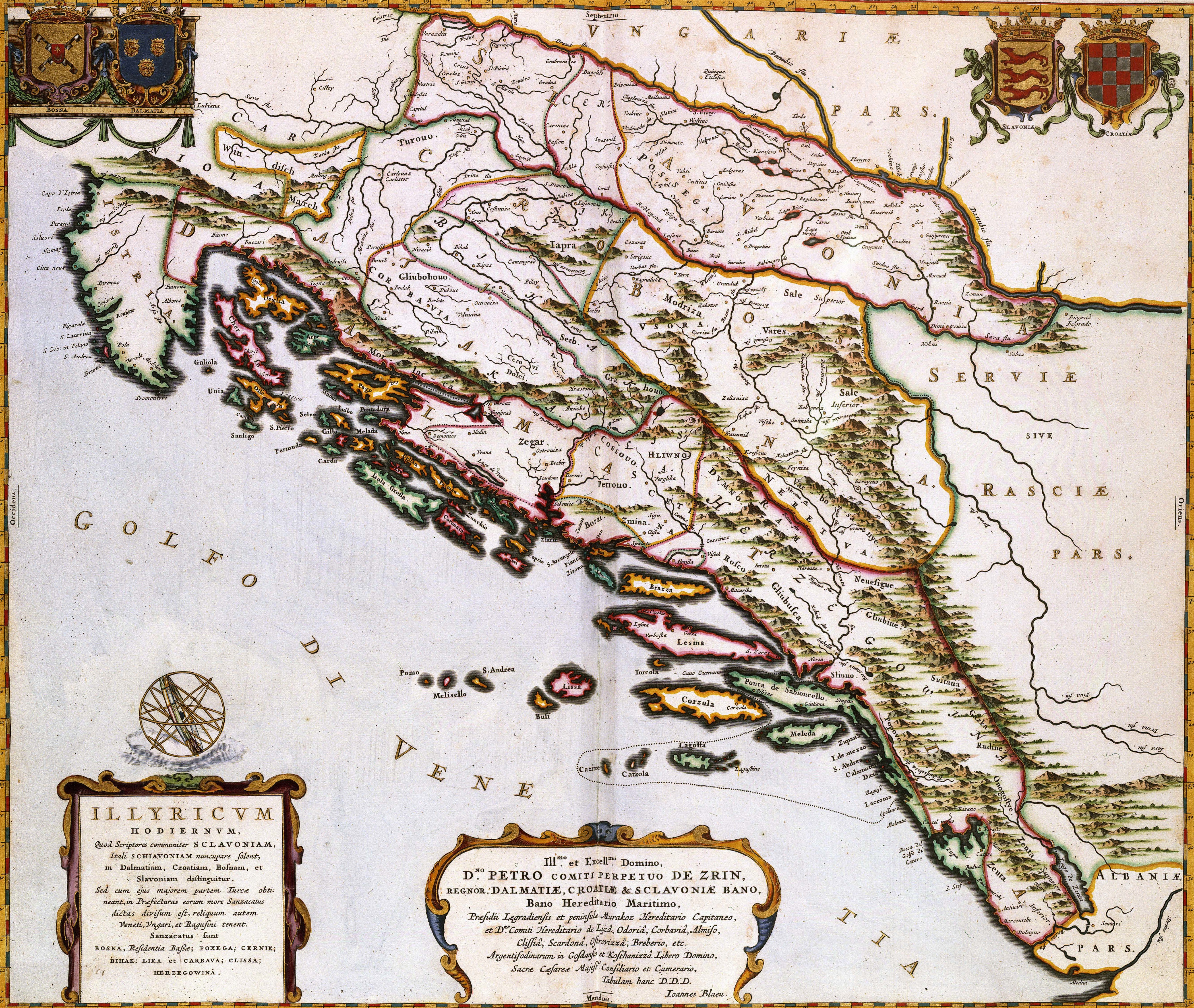
| ILIYRICVM HODIERNVM, Quod Scriptores communiter SCLAVONIAM, Itali SCHIAVONIAM nuncupare solent, in Dalmatiam, Croatiam, Bosnam, et Slavoniam
( |
|||||||||||||||||||||||||||
|---|---|---|---|---|---|---|---|---|---|---|---|---|---|---|---|---|---|---|---|---|---|---|---|---|---|---|---|
| Author |
Publisher:
|
||||||||||||||||||||||||||
| Title |
ILIYRICVM HODIERNVM, Quod Scriptores communiter SCLAVONIAM, Itali SCHIAVONIAM nuncupare solent, in Dalmatiam, Croatiam, Bosnam, et Slavoniam |
||||||||||||||||||||||||||
| Object type | map | ||||||||||||||||||||||||||
| Description |
Nederlands: Deze kaart van de oostkust van de Adriatische Zee werd in 1663 door Joan Blaeu (1598-1673) gepubliceerd in de franse editie van zijn Atlas Maior. Waarschijnlijk kopieerde Blaeu de afbeelding uit een moderne Franse bron, wat niet betekende dat het kaartbeeld daarmee ook actueel was. Door de Turkse bezetting gedurende de 17de eeuw was het gebied nauwelijks toegankelijk waardoor kartografen veelvuldig gebruik maakten van verouderd kaartmateriaal uit de 16de eeuw.; Middenonder een opdracht van Joan Blaeu aan de graaf Perpetuo de Zrin.
English: This map of the eastern coast of the Adriatic Sea was published in 1663 by Joan Blaeu (1598-1673) in the french edition of his Atlas Maior. Blaeu probable copied the image from a contemporary French source, which did not garantee the maps actuality. Because of the Turkish occupation in the 17th century the area was hardly accessible. For that reason cartographers often had to rely on older materials from the 16th century. |
||||||||||||||||||||||||||
| Date | 1663 | ||||||||||||||||||||||||||
| Medium |
Nederlands: kopergravure
English: copper engraving print |
||||||||||||||||||||||||||
| Dimensions | 44 x 52 cm | ||||||||||||||||||||||||||
| Collection |
|
||||||||||||||||||||||||||
| Accession number |
Description of the Atlas Van der Hagen in the catalogue of the KB: http://opc4.kb.nl/DB=1/TTL=1/LNG=EN/PPN?PPN=353012750 |
||||||||||||||||||||||||||
| Place of creation | Amsterdam | ||||||||||||||||||||||||||
| Notes | KW1049B12_084 - Volume 1 | ||||||||||||||||||||||||||
| Related persons | Joan Blaeu - Perpetuo de Zrin, graaf | ||||||||||||||||||||||||||
| Depicted locations | Adriatic Sea - Croatia - Dalmatia - Bosnia-Hercegovina | ||||||||||||||||||||||||||
| Source/Photographer |
Source page at the Geheugen van Nederland / Memory of the Netherlands website.
|
||||||||||||||||||||||||||
| Permission (Reusing this file) |
|
||||||||||||||||||||||||||
| Other versions | |||||||||||||||||||||||||||
.jpg)


File history
Click on a date/time to view the file as it appeared at that time.
| Date/Time | Thumbnail | Dimensions | User | Comment | |
|---|---|---|---|---|---|
| current | 03:42, 23 January 2022 | | 5,353 × 4,520 (8.09 MB) | Santasa99 |
File usage
The following pages on the English Wikipedia use this file (pages on other projects are not listed):
- 1898 Trilj earthquake
- Austro-Hungarian rule in Bosnia and Herzegovina
- Ban of Croatia
- Ban of Slavonia
- Banate of Bosnia
- Banovina of Croatia
- Bosnia (early medieval)
- Bosnia Eyalet
- Bosnia Vilayet
- Bosnia and Herzegovina in the Middle Ages
- Bosniak National Awakening
- Bosnian uprising (1831–1832)
- Croatia during World War I
- Croatia in personal union with Hungary
- Croatian Military Frontier
- Croatian Partisans
- Croatian War of Independence
- Croatian affairs in the Kingdom of Yugoslavia
- Duchy of Croatia
- Early history of Bosnia and Herzegovina
- History of Bosnia and Herzegovina
- History of Bosnia and Herzegovina (1941–1945)
- History of Croatia
- History of Croatia (1995–present)
- History of Croatia before the Croats
- History of Istria
- History of Split
- History of Zagreb
- History of the Jews in Croatia
- Illyrian kingdom
- Independence of Croatia
- Independent State of Croatia
- Jewish people of Bosnia and Herzegovina
- Kingdom of Bosnia
- Kingdom of Croatia-Slavonia
- Kingdom of Croatia (Habsburg)
- Kingdom of Dalmatia
- Kingdom of Slavonia
- Lands of the Crown of Saint Stephen
- Military Frontier
- Origin hypotheses of the Croats
- Ottoman Bosnia and Herzegovina
- Ottoman conquest of Bosnia and Herzegovina
- Pannonia
- Red Croatia
- Republic of Poljica
- Sanjak of Bosnia
- Sava Banovina
- Slavonia
- Slavonian Military Frontier
- Socialist Republic of Bosnia and Herzegovina
- Socialist Republic of Croatia
- Soli (zemlja)
- Stanak
- Stjepan Vukčić Kosača
- Timeline of Rijeka
- Timeline of Split
- Timeline of Zagreb
- Timeline of the Croatian War of Independence
- Timeline of the Croat–Bosniak War
- Usora (zemlja)
- Vlachs in medieval Bosnia and Herzegovina
- Zachlumia
- Zemlja (feudal Bosnia)
- User:Santasa99/sandbox10
- User:Zoupan/Zachumlia
- User:༆/History of Europe templates
- Wikipedia:WikiProject Bosnia and Herzegovina/Templates
- Template:History of Bosnia and Herzegovina
- Template:History of Croatia
Global file usage
The following other wikis use this file:
- Usage on hr.wikipedia.org
- Usage on it.wikipedia.org
- Usage on sq.wikipedia.org
- Usage on zh.wikipedia.org