
Graystone Peak
| Graystone Peak | |
|---|---|
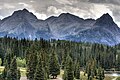
 Northwest aspect, from Molas Lake | |
| Highest point | |
| Elevation | 13,489 ft (4,111 m)[1][2] |
| Prominence | 502 ft (153 m)[3] |
| Parent peak | Arrow Peak (13,809 ft)[3] |
| Isolation | 0.56 mi (0.90 km)[3] |
| Coordinates | 37°41′21″N 107°37′09″W / 37.6892161°N 107.6191513°W[4] |
| Geography | |
 Graystone Peak Location in Colorado  Graystone Peak Graystone Peak (the United States) | |
| Country | United States |
| State | |
Graystone Peak is a 13,489-foot-elevation (4,111-meter) mountain summit located in San Juan County, Colorado, United States.
Description
Graystone Peak is situated 8.5 miles (13.7 km) south-southeast of the community of
Climate
According to the Köppen climate classification system, Graystone Peak is located in an alpine subarctic climate zone with very long, cold, snowy winters, and cool to warm summers.[6] Due to its altitude, it receives precipitation all year, as snow in winter and as thunderstorms in summer, with a dry period in late spring.
Geology
Graystone Peak is part of the Uncompahgre Formation,[7] which is a sequence of quartzite and black phyllite some 8,200 feet (2,500 meters) in thickness.[8] The formation dates to the Statherian period and is interpreted as metamorphosed marine and fluvial sandstone, mudstone, and shale. The formation overlies plutons with an age of 1,707 million years.
Gallery
-
 Electric Peak, Graystone Peak (center), Mt. Garfield (right) viewed from Molas Lake
 -
 Electric Peak, Graystone Peak (center), Mt. Garfield (right) from Molas Lake
 -
 Electric Peak, Graystone Peak (center), Mt. Garfield (right)
 -
 Northeast aspect of Arrow Peak to left, Graystone Peak centered and Electric Peak to right
 -
 Graystone Peak to the right
 -
 Graystone Peak centered
.jpg)


See also
References
- ^ Robert F. Rosebrough, The San Juan Mountains: A Climbing & Hiking Guide, Cordillera Press, 1986, page 170.
- ^ a b c "Graystone Peak, Colorado". Peakbagger.com. Retrieved May 24, 2023.
- ^ a b c d "Graystone Peak - 13,503' CO". listsofjohn.com. Retrieved May 24, 2023.
- ^ a b "Graystone Peak". Geographic Names Information System. United States Geological Survey, United States Department of the Interior. Retrieved May 24, 2023.
- ^ Henry Gannett, United States Geological Survey (1906), A Gazetteer of Colorado, US Government Printing Office, p. 80.
- ISSN 1027-5606.
- ^ Colorado Needle Mountains Quadrangle, Charles D. Walcott, U.S. Geological Survey, 1906.
- ISBN 9780870813788, page 350.
External links
- Weather forecast: Graystone Peak
Places adjacent to Graystone Peak | ||||||||||||||||
|---|---|---|---|---|---|---|---|---|---|---|---|---|---|---|---|---|
| ||||||||||||||||