
Neustadt an der Aisch
This article needs additional citations for verification. (May 2015) |
Neustadt an der Aisch | |
|---|---|
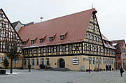
 Town hall | |
 Coat of arms | |
Location of Neustadt an der Aisch within Neustadt (Aisch)-Bad Windsheim district  | |
 Neustadt an der Aisch  Neustadt an der Aisch | |
| Coordinates: 49°35′48″N 10°36′32″E / 49.59667°N 10.60889°E | |
| Country | Germany |
| State | Bavaria |
| District | Neustadt (Aisch)-Bad Windsheim |
| Government | |
| • Mayor (2020–26) | Klaus Meier[1] (SPD) |
| Population (2022-12-31)[2] | |
| • Total | 13,419 |
| Time zone | UTC+01:00 (CET) |
| • Summer (DST) | UTC+02:00 (CEST) |
| Postal codes | 91413 |
| Dialling codes | 09161 |
| Vehicle registration | NEA |
| Website | www.neustadt-aisch.de/ |
Neustadt an der Aisch (officially: Neustadt a.d. Aisch) is a small town of around 13,000 inhabitants in the northern part of Bavaria (Germany), within the Franconian administrative region Middle Franconia.[3] It is the district town of the district Neustadt (Aisch)-Bad Windsheim.
History
In 741, for the first time, Riedfeld, the town's root settlement, was documented as the German king's court. However, in 1285 the town's name is documented for the first time as "Nivenstadt".
At the end of the 12th century, Neustadt became part of the sovereign territory of the
At the end of the 15th century,
In 1553, in the Second Margrave War, the town was burnt down. Afterwards, a long lasting phase of construction and extension began. This phase ended with the destructions of the Thirty Years' War. The rebuilding after that war lasted several hundred of years.
From 1791 through to 1806, Neustadt was part of the sovereign territory of
In 1934, the town was the scene of an organized
During the 20th century, traditional handicrafts (like brush-makers and makers of drawing instruments) almost completely vanished. With the resettlement of expellees from Sudetenland, new handicraft industries were imported: construction of musical instruments and the textile industry flourished.
From 1969 through to 1980, in total 16
In the 1980s and 1990s, the infrastructure was improved on a grand scale: a
Gallery
-
 Town gate: das Nürnberger Tor
 -
 Street art near der NeustadtHalle
 -
 Bar Uncle Frank
 -
 Sparkasse on market square


Subdivisions
- Birkenfeld (including Weiherhof)
- Diebach
- Eggensee (including Chausseehaus)
- Herrnneuses (incl. Oberstrahlbach)
- Kleinerlbach
- Obernesselbach
- Unterschweinach
- Oberschweinach (incl. Stöckach)
- Schauerheim (incl. Hasenlohe and Virnsbergerhaag)
- Schellert
- Unternesselbach
Notable people
Born in Neustadt

- Sevilla), merchant, in cooperation with Jacob and Hans Cromberger founder of the Deutscher Amerikahandel
- Adolf Scherzer (1815–1864), composer of the Bayerischer Defiliermarsch
- Werner Dollinger (1918–2008), German politician (CSU), member of the Bundestag (1953–1990), treasury secretary (1962–1966), minister of postal services and telecommunication (1966–1969), minister of transport (1982–1987)
- Armin Schwarz (born 1963), German rally driver
- Julian Gressel (born 1993), football player
- Niklas Stark (born 1995), football player
Honorary citizens
- Paul von Hindenburg (1847–1934), Generalfeldmarschall and President of the German Reich, since 30 March 1933
- Max Döllner (1874-1959), Oberregierungsrat and Obermedizinalrat, documentarist of his country, since 26 March 1954
- Werner Dollinger (1918–2008), German politician (CSU), since 10 October 1978
People otherwise associated with Neustadt an der Aisch

- Albrecht III Achilles, Elector of Brandenburg (born 1414 in Tangermünde; died 1486 in Frankfurt/Main), Prince-elector of the Margraviate of Brandenburg, he also ruled the Principality of Ansbach
- Hof
- Peter Kolb (born 1675 in Dörflas, today district of Marktredwitz; died 1726 in Neustadt an der Aisch), teacher and ethnologist
- Jean Paul (born 1763 in Wunsiedel; died 1825 in Bayreuth; in fact Johann Paul Friedrich Richter), author
- Hans W. Geißendörfer (born 1941 in Augsburg), film director, author and producer
- Guido Knopp (born 1948 in Treysa, today's town district of Schwalmstadt), historian, author and journalist
- Lissy Gröner (born 1954 in Langenfeld; died 2019), German politician (SPD), Member of the European Parliament 1989-2009
- Nevio Passaro (born 1981 in Bad Windsheim), German-Italian singer, songwriter and producer
- Augustus Schwaab (1823–1899), architect and civil engineer who emigrated to the United States
Town twinning
|
References
- Bayerisches Landesamt für Statistik, 15 July 2021.
- ^ Genesis Online-Datenbank des Bayerischen Landesamtes für Statistik Tabelle 12411-003r Fortschreibung des Bevölkerungsstandes: Gemeinden, Stichtag (Einwohnerzahlen auf Grundlage des Zensus 2011) (Hilfe dazu).
- ^ "Neustadt an der Aisch" (mapping), 2007, webpage: Airport-map-657610.
- ^ . Encyclopædia Britannica. Vol. VIII (9th ed.). 1878. p. 133.
External links
- official home page of Neustadt an der Aisch
- Webcam of the market place.
- informations for genealogists in GenWiki.
Towns and municipalities in Neustadt (Aisch)-Bad Windsheim | ||
|---|---|---|
|  | |
| International | |
|---|---|
| National | |
| Geographic | |