
Rangpur, Bangladesh
Rangpur
রংপুর | ||
|---|---|---|
Metropolis | ||
 .jpg)     From top (clockwise): Postal code 5400[2] | ||
| Police | Rangpur Metropolitan Police | |
| Calling Code | 521 | |
| Website | rpcc | |
Rangpur (
Rangpur was declared a district headquarters on December 16, 1769, and established as a municipality in 1869, making it one of the oldest municipalities in Bangladesh. [3]The municipal office building was erected in 1892 under the precedence Raja Janaki Ballav. Rangpur City Corporation is the 2nd largest city corporation in Bangladesh by area at about 205 square km.
Previously serving as the headquarters of the Greater Rangpur district, Rangpur underwent administrative restructuring, resulting in the formation of the Gaibandha, Kurigram, Lalmonirhat, Nilphamari, and Rangpur districts.
History

Etymology
It is said that the present name Rangpur came from the former 'Rongpur'. History has it that English colonial rulers in this region started cultivating
Early history
According to Hindu theology, the eastern kingdom of Kamarupa or Pragjyotisha existed in India, which included the present Rangpur region. During the reign of King Bhagadatta (15th century BC) Rangpur belonged to Pragjyotisha Kingdom. During the reign of King Samudragupta (340 AD) Rangpur was considered a "Tax state" of Kamarupa.[6]
Mughal Period
According to Ain-i-Akbari, the Mughal period Rangpur consisted of three types of administrative areas. Rangpur was conquered by the army of
British Period
After the East India Company gained "Deoani" in 1765, Rangpur came under British rule. The
Pakistani Period and Liberation War
Rangpur was a District of
Post-Independence Period
The Greater Rangpur district was divided in five districts in 1984. On 28 June 2012 Rangpur Municipality was upgraded to Rangpur City Corporation and on 16 September 2018 Rangpur was granted as 8th Metropolitan city of Bangladesh.[11][12]
Geography
Rangpur City is the divisional headquarters of Rangpur Division. The soil composition is mainly
Climate
Rangpur has a
have never been recorded in Rangpur.| Month | Jan | Feb | Mar | Apr | May | Jun | Jul | Aug | Sep | Oct | Nov | Dec | Year |
|---|---|---|---|---|---|---|---|---|---|---|---|---|---|
| Record high °C (°F) | 29.4 (84.9) |
34.4 (93.9) |
43.3 (109.9) |
42.5 (108.5) |
41.2 (106.2) |
37.0 (98.6) |
34.0 (93.2) |
36.5 (97.7) |
34.7 (94.5) |
37.2 (99.0) |
33.4 (92.1) |
30.6 (87.1) |
43.3 (109.9) |
| Mean daily maximum °C (°F) | 23.1 (73.6) |
26.3 (79.3) |
30.4 (86.7) |
31.7 (89.1) |
31.8 (89.2) |
31.9 (89.4) |
31.7 (89.1) |
32.2 (90.0) |
31.5 (88.7) |
30.7 (87.3) |
25.5 (77.9) |
25.1 (77.2) |
29.3 (84.8) |
| Daily mean °C (°F) | 16.3 (61.3) |
19.2 (66.6) |
23.4 (74.1) |
26.1 (79.0) |
27.4 (81.3) |
28.4 (83.1) |
28.6 (83.5) |
28.9 (84.0) |
28.0 (82.4) |
25.2 (77.4) |
21.2 (70.2) |
18.2 (64.8) |
24.2 (75.6) |
| Mean daily minimum °C (°F) | 10.9 (51.6) |
13.2 (55.8) |
17.3 (63.1) |
21.2 (70.2) |
23.3 (73.9) |
25.3 (77.5) |
26.0 (78.8) |
26.3 (79.3) |
25.3 (77.5) |
21.6 (70.9) |
17.4 (63.3) |
13.0 (55.4) |
20.1 (68.1) |
| Record low °C (°F) | 3.5 (38.3) |
3.7 (38.7) |
8.6 (47.5) |
14.7 (58.5) |
16.4 (61.5) |
19.4 (66.9) |
21.1 (70.0) |
20.7 (69.3) |
19.1 (66.4) |
14.2 (57.6) |
10.1 (50.2) |
5.2 (41.4) |
3.5 (38.3) |
| Average precipitation mm (inches) | 9.2 (0.36) |
12.5 (0.49) |
25.9 (1.02) |
118.4 (4.66) |
267.7 (10.54) |
467.1 (18.39) |
476.5 (18.76) |
344.8 (13.57) |
390.1 (15.36) |
180.5 (7.11) |
8.7 (0.34) |
8.1 (0.32) |
2,309.5 (90.92) |
| Average rainy days | 2 | 2 | 3 | 8 | 15 | 18 | 21 | 17 | 17 | 7 | 1 | 1 | 112 |
| Average relative humidity (%)
|
82 | 75 | 68 | 74 | 81 | 85 | 86 | 85 | 87 | 84 | 80 | 81 | 81 |
| Source: Bangladesh Meteorological Department[14][15][16] | |||||||||||||
Economy
.jpg)
The city is the commercial hub. Its center has several government offices and private banks, insurance companies, residential hotels, and international restaurants, such as Chinese, Thai, Indian, Mexican, convenience food, and gift shops. It is one of the most important economic zones in Bangladesh because of its global positioning. Rangpur is one of the major Tobacco producing region in Bangladesh.[17] The northern suburbs of Rangpur homes to tobacco companies like British American Tobacco, Akij Group, Abul Khair Group.
Demographics

| Year | Pop. | ±% |
|---|---|---|
| 1950 | 34,000 | — |
| 1960 | 44,000 | +29.4% |
| 1970 | 68,000 | +54.5% |
| 1980 | 134,000 | +97.1% |
| 1991 | 191,398 | +42.8% |
| 2001 | 241,310 | +26.1% |
| 2011 | 300,659 | +24.6% |
| 2022 | 708,534 | +135.7% |
| Source: popstat,pre-1991,citypopulation.de after 1991,2022 census | ||
According to the 2022 Bangladesh census, Rangpur city had a population of 708,534 and a literacy rate of 80.94%.[19]: 388–394
According to the 2011 Bangladesh census, Rangpur city had 64,885 households and a population of 300,659. 51,791 (17.23%) were under 10 years of age. Rangpur had a literacy rate (age 7 and over) of 72.08%, compared to the national average of 51.8%, and a sex ratio of 926 females per 1000 males.[18]
Education
Major educational institutes in the city including:
Universities
- Begum Rokeya University
Medical and dental colleges
- Rangpur Medical College
- Prime Medical College
- Rangpur Community Medical College
- Northern Private Medical College.
- Rangpur Army Medical College
- Kasir Uddin Memorial Medical College
- Rangpur Dental College
Polytechnic institutes


Colleges
- Begum Rokeya College
- Rangpur Engineering College
- Carmichael College[20]
- Dr M A Wazed Miah Textile Engineering College
- Pirganj Marine Academy
- Collectorate School and College
- Carmichael Collegiate School and College
- Rangpur Model College
- Police Lines School and College
- Rangpur Cadet College
- Cantonment Public School And College, Rangpur
- BIAM Model School And College, Rangpur
- Rangpur Technical School and College
- Rangpur Government College
- RCCI Public School & College
- Lions School & College
- The Millennium Stars School & College
- Somaj Kolyan Women School & College
- Residential Model School and College
- Mahigong College
- Rangpur Public School and College
- Uttom College
- Rangpur City College
- Robertsonganj High School & College
- Robertsonganj Girls' High School & College
- Siddique Memorial School & College
- Dhap Lalkuthi High School & College
Affiliated colleges
- International Institute of Applied Science and Technology, Rangpur
Schools
- Cantonment Public School And College, Rangpur
- Rangpur Zilla School
- Rangpur Govt. Girls' High School
- Govt. Commercial Institute
- Rangpur High School
- Salma Girls High School
- Afanullah High School, Alamnagar
- Adasha High School, Babukha
- Shalbon Pauro Girls High School
- Tajhat High School
- Mahabbat Khan High School
English medium schools
- The Millennium Stars School & College
- Shahan International School
- Nalanda International School
- International Grammar School
- BIAM Laboratory School
Neighbourhoods

Rangpur City Corporation is divided into 33 wards and different neighbourhoods (Mahallah), which can be categorized as Urban and Suburban.
- Burirhat
- Chabbis Hazari
- Panadardighi
- Uttam
- Hazirhat
- CO Bazar
- Dhap
- Kellabond
- Radhaballov
- Shimulbag-Sagarpara
- Keranipara
- Munshipara
- Lalkuthi lane
- Khalifapara
- Jummapara
- Jahaj Company
- Nababgonj
- Betpotti-Taltola
- Kotkipara
- Parjantan Para
- Modern
- Ashratpur
- Alamnagar
- Robertsonganj
- Darshana
- Lalbagh
- Khamarpara
- Islampur
- Pirjabad
- Parbatipur
- Mahiganj
- Tajhat
- Ganeshpur
- Babukha
- DC More
- Adarshapara
- Mistry Para
Transport
Road

Rangpur is well connected by highways to Chittagong and Dhaka, as well as other parts of Rangpur. It takes about 6 to 7 hours by road to reach the capital Dhaka by
Railway
The Rangpur Railway Station is the main railway station providing trains on national routes operated by the state-run Bangladesh Railway. The Rangpur Express[22] is a Bangladeshi Intercity train which runs between Rangpur and Dhaka. Other trains running between Rangpur and Dhaka are, Kurigram Express and Lalmoni Express.
Air
The city of Rangpur is served by Saidpur Airport, located at the north of the city. Saidpur airport is a domestic airport. Saidpur Airport is connected through several private airlines such as Novoair, US-Bangla Airlines, Regent Airways & Biman Bangladesh Airlines a government airline with Capital city of Bangladesh Dhaka. A massive renovation work is going on at Saidpur Airport ahead of its planning to become the new International Airport for Northern Bangladesh region.
Sports

Cricket is the most popular sport in Rangpur, Bangladesh, while field hockey, basketball, baseball, and tennis are also popular.[23]
The most popular sport in Rangpur is cricket, although football is also popular. There is a 10,000-capacity
Notable people
Gallery
-
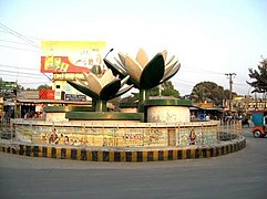 Shapla Chottor.
 -
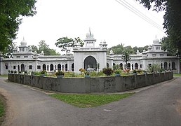 Zilla Porishod Building.
 -
 Jahaj Company area (downtown Rangpur) at night
 -
 Parjatan Hotel.
 -
 Terminal Mosque (Masjid).
 -
 Rangpur Modern.
 -
 Begum Rokeya Memorial Centre.
 -
 Jadu Nibash - an ancient house
 -
 Ekattorer Boddho Bhumi - Memorial of Town Hall Massacre during 1971
 -
 Begum Rokeya Universityat night
 -
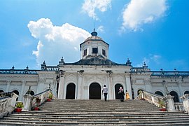 Tajhat Palace


.jpg)


References
- ^ নতুন মেয়র বললেন রংপুর বদলে যাবে | কালের কণ্ঠ. Kaler Kantho (in Bengali).
- ^ "ZIP Code database of Bangladesh, Rangpur, Rangpur, Rangpur Sadar". Geopostcodes.com. Retrieved 11 June 2013.
- ^ a b "Journey to Rangpur City Corporation". Archived from the original on 17 June 2015. Retrieved 17 June 2015.
- ^ "Rangpur". britannica. Archived from the original on 17 June 2015. Retrieved 17 June 2015.
- ^ রংপুর জেলা. Rangpur District. Retrieved 16 June 2021.
- ^ a b রংপুর জেলা. Rangpur District. Retrieved 16 June 2021.
- OL 30677644M. Retrieved 25 April 2024.
- ^ "Devi Chaudhurani--Bengal's very own Bandit Queen". Get Bengal. Retrieved 16 June 2021.
- ^ Haq, Ariful. ঘাঘট সেদিন রক্তে লাল হয়েছিল. Prothom Alo (in Bengali). Retrieved 16 June 2021.
- ^ "Liberation war began decisively on March 28 in Rangpur". Dhaka Tribune. 13 March 2021. Retrieved 16 June 2021.
- ^ "Rangpur turns city corporation". The Daily Star. 2 July 2012. Retrieved 16 June 2021.
- ^ "Rangpur Metropolitan Police launches Sept 16". Risingbd.com. Retrieved 16 June 2021.
- ^ "Worldwide Elevation Finder". elevation.maplogs.com. Retrieved 1 June 2021.
- ^ "Climate of Bangladesh" (PDF). Bangladesh Meteorological Department. pp. 19–23. Archived from the original (PDF) on 24 December 2018. Retrieved 24 December 2018.
- ^ "Normal Monthly Rainy Day" (PDF). Bangladesh Meteorological Department. Archived from the original on 9 July 2017. Retrieved 24 December 2018.
- ^ "Normal Monthly Humidity" (PDF). Bangladesh Meteorological Department. Archived from the original on 24 December 2018. Retrieved 24 December 2018.
- ^ "Tobacco cultivation still on in Rangpur region". Dhaka Tribune. 2 January 2014. Retrieved 1 June 2021.
- ^ a b "Population & Housing Census 2011 (Zila Series & Community Series)". bbs.gov.bd. Bangladesh Bureau of Statistics.
- ^ Population and Housing Census 2022 National Report (PDF). Vol. 1. Bangladesh Bureau of Statistics. November 2023.
- ^ Muhammad Maniruzzaman (2012). "Carmichael College, Rangpur". In Sirajul Islam; Ahmed A. Jamal (eds.). Banglapedia: National Encyclopedia of Bangladesh (Second ed.). Asiatic Society of Bangladesh. Archived from the original on 17 June 2015. Retrieved 17 June 2015.
- ^ "BRTC launches city bus service in Rangpur". The Financial Express. Dhaka. Retrieved 11 June 2021.
- ^ "Dhaka-Rangpur railway inaugurated". The Daily Star. 22 August 2011. Retrieved 11 June 2021.
- ISSN 2589-8760.
- ^ Cricket Garden, Rangpur, CricketArchive.com Retrieved on 29 July 2010.
- ^ Players and Officials – Nasir Hossain Cricinfo.
- ^ Players and Officials – Suhrawadi Shuvo Cricinfo.
External links
- Rangpur City Corporation
- Rangpur oriented website
- Abdus Sattar (2012). "Rangpur District". In Sirajul Islam; Ahmed A. Jamal (eds.). Banglapedia: National Encyclopedia of Bangladesh (Second ed.). Asiatic Society of Bangladesh. Retrieved 13 May 2016.
