Sangareddy district
Sangareddy district | |
|---|---|
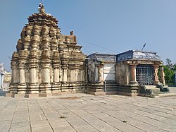
 Ramalingeshwara temple, Nandikandi | |
 Location in Telangana | |
| Coordinates (Sangareddy): 17.780532, 77.892057 | |
| Country | |
| State | Telangana |
| Mandals | 28 |
| Established | 11 October 2016[1] |
| Founded by | Government of Telangana, |
| Headquarters | Sangareddy |
| Revenue Divisions | 04 |
| Government | |
| • Type | Zilla Panchayath |
| • Body | Sangareddy Zilla Panchayath |
| • Collector | Dr. A Sharath IAS |
| Area | |
| • Total | 4,996.46 km2 (1,929.14 sq mi) |
| Population (2015) | |
| • Total | 1,526,026 |
| • Density | 310/km2 (790/sq mi) |
| Time zone | UTC+05:30 (IST) |
| Vehicle registration | TS 15 |
| Major highways | |
| Website | sangareddy |
Sangareddy district, is a
Rangareddy districts and with the state boundary of Karnataka
.
Geography
The district is spread over an area of 4,464.87 square kilometres (1,723.90 sq mi).[4]
Demographics
At the time of the 2011 census, Sangareddy district had a population of 1,526,026. Sangareddy has a sex ratio of 965 females per 1000 males and a literacy rate of 64.03%. 194,674 (12.76%) were under 6 years of age. 529,965 (34.73%) lived in urban areas. Scheduled Castes and Scheduled Tribes made up 276,595 (18.13%) and 86,410 (5.66%) of the population respectively.[6]
At the time of the 2011 census, 71.24% of the population spoke Telugu, 15.46% Urdu, 5.05% Lambadi, 3.76% Kannada, 1.74% Hindi and 1.32% Marathi as their first language.[7]
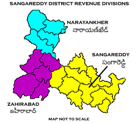
Administrative divisions
The district has four
Mandals

| S.No. | Sangareddy revenue division | Narayankhed revenue division | Zaheerabad revenue division | Andole-Jogipet |
|---|---|---|---|---|
| 1 | Ameenpur | Kalher | Jharasangam | Andole |
| 2 | Gummadidala | Manoor
|
Mogudampally | Pulkal |
| 3 | Hathnoora | Nagilgidda | Nyalkal | Chowtakur |
| 4 | Jinnaram | Narayankhed | Raikode | Vatpally |
| 5 | Kandi | Sirgapoor | Zahirabad
|
|
| 6 | Kondapur
|
Nizampet | Kohir | |
| 7 | Munipally | Kangti | ||
| 8 | Patancheru | Tadkal | ||
| 9 | Ramachandrapuram | |||
| 10 | Sadasivpet | |||
| 11 | Sangareddy |
See also
- List of districts in Telangana
References
- ^ District Sangareddy, Government of Telangana | India
- ^ a b "Sangareddy district" (PDF). New Districts Formation Portal. Retrieved 11 October 2016.
- ^ "About District- District Sangareddy, Government of Telangana". Telangana State Portal. Government of Telangana. Retrieved 2 January 2024.
- ^ "New districts". Andhra Jyothy.com. 8 October 2016. Retrieved 8 October 2016.
- ^ "Population by Religion - Andhra Pradesh". Census of India. Registrar General and Census Commissioner of India. 2011.
- ^ "Know your district Plan your district - Sangareddy" (PDF). trac.telangana.gov.in. Telangana State Remote Sensing Applications Centre.
- ^ a b "Table C-16 Population by Mother Tongue: Andhra Pradesh". Census of India. Registrar General and Census Commissioner of India.
- ^ "K Chandrasekhar Rao appoints collectors for new districts". Deccan Chronicle. 11 October 2016. Retrieved 13 October 2016.
External links

