
Smoke Hole Canyon
| Smoke Hole Canyon | |
|---|---|
 View of Smoke Hole Canyon from atop Cave Mountain. Visible are the South Branch Potomac River and the Big Bend (bottom), as well as Castle Rock and North Fork Gap (distance). | |
 Smoke Hole Canyon | |
| Floor elevation | 1,100 feet (300 m) |
| Length | 20.7 miles (33.3 km) |
| Geography | |
| Coordinates | 38°51′35″N 79°17′04″W / 38.85965°N 79.28445°W |
| Rivers | South Branch Potomac River |
Smoke Hole Canyon — traditionally called The Smoke Holes[1] and later simply Smoke Hole — is a rugged 20 miles (32 km) long gorge carved by the South Branch Potomac River in the Allegheny Mountains of eastern West Virginia, United States. The area is rather isolated and remote with parts accessible only by boat or on foot.
Defined to the east by Cave Mountain and to the west by North Fork Mountain, Smoke Hole has been part of the Monongahela National Forest's Spruce Knob–Seneca Rocks National Recreation Area since 1965, although some of it is still private land. Formerly, the area was home to a scattered community of family homesteads, storied for their isolation, traditional lifestyles, and skilled production of the illicit liquor known as "moonshine". Today, The Nature Conservancy considers Smoke Hole and the surrounding mountains to be "one of the most biologically rich places in the East", especially as regards its rare plant communities. It included the Canyon as part of the greater Smoke Hole-North Mountain Bioreserve during its "Last Great Places" campaign.
Geography and description
Smoke Hole is situated in southern
The main — and traditional — entrance into the Smoke Hole is from the south through a

Eons ago — through a process known as
) High above the river, on the north side of the gap, is a prominent range of limestone cliffs which represent the Cave Mountain Anticline. Here also, at river level, is a very prominent crag — Eagle Rock. A bit further on, Cat Path Rocks, a perpendicular cliff, has been partially cut through by the roadbed and is followed by another outcropping known as High Rocks.About two miles downstream of the entrance, the river bifurcates to create the low-lying Hermit Island (4.5 acres), formerly a popular picnicking ground and site of a two-storey log cabin that served as a community center ("Calhoun's Community Camp") from 1928.[5] Almost directly across the river, and high on the hillside, is the Canyon's namesake, Smoke Hole Cave. Passing on down the river, one encounters Fishing Rock and Fishing Rock Ford and finally comes, at 3.8 miles from the entrance, to an intersection near Shreve's Country Store, Smoke Hole Campground and the old Palestine Church ("Old Log Church"). This area was the center of the "town of Smoke Hole" proper, site of an official post office for a time. From here a steep Forest Service road switchbacks 5.4 miles up to the former site of the North Fork Mountain Lookout Tower. Grant County Route 28/11 also proceeds from this intersection and traverses the northern half of the Canyon well above the river level for about 12 miles (19 km) where it exits the Canyon at WV Route 55/28. (NB: Both Grant County Route 28/11 and Pendleton County Route 2 are indicated on maps as "Smoke Hole Road". The former was previously called FR 74.)

From the Shreve's Country Store intersection, CR 2 continues north another two miles along the river (past Old Mines Cave Rocks, mile 4.1 and Old Mines Cave, mile 5.8) to the abandoned town of Ketterman (mile 6.3) — also site of an erstwhile post office — and then a final mile to Big Bend Campground (mile 7.3) where the motorable roadway ends. Big Bend constitutes an unusual "peninsula" in the river; the river here loops for about 1.3 miles back to a point just 350 feet from itself. (The narrow ridge between the riverbanks here was traditionally known as "Arm Ridge".)
The South Branch collects a number of minor streams in the Canyon; these include Briggs Run (0.6 mile from the entrance), Dry Hollow Run (mile 1.0), Chevaux-de-fris Run (mile 3.8, at the road intersection), Short (Pack Saddle) Run (mile 5.5), Long (Feather Bed) Run (mile 5.8), and — beyond the Big Bend — Redman Run (mile 13.3) and Landes Hollow Run (mile 16.6). Beyond the Big Bend, the Canyon has the character of a remote wilderness; it is one of the most isolated regions of the state and can be traversed only on foot or by boat. Formerly, a primitive wagon road threaded its way through the lower Canyon, but most traces of this are long gone. Prominent named crags and caves along this section include Indian House Cave (mile 10.1), Castle Rock (mile 11.3), Blue Rock (mile 16.2), and Bulls Head (mile 16.6), just below which is Peacock Cave (mile 16.6). About 3 miles on (mile 20.7), the river debouches from the Canyon. After another half mile, the South Branch collects the
History
Early settlers
The first Smoke Hole settlers followed quickly on the heels of the first in the South Branch valley, which arrived in the late 1740s. A man named Steele (given name now lost) was the first Smoke Holer, arriving sometime in the 1750s. He built a cabin near the (still standing) Palestine Church and his daughter Katie married another pioneer, George Full — the first wedding celebrated in the Canyon.
The earliest settler families — the
The origin of the name "Smoke Hole" is undocumented. Some old timers used to refer to the area as the "Smoke Holes". The oldest explanation appears to be the story that Native Americans used a well-known cave in the gorge (Smoke Hole Cave) for smoking meat; this cave has a room shaped like an inverted funnel with a hole at the apex through which smoke could escape and be seen from some distance.

The 19th century
The earliest settler families were followed, a generation or two later, by a second wave — the Kimbles, Alts, Stumps, Judys, Helmicks, and Kettermans.[14]
A still extant log church — Palestine Church — was built as a
The nearby cavern known as "Big Cave", on Cave Mountain, was a source of
Early 20th-century life
Descriptions of conditions prevailing in the Smoke Hole during the early 20th century were highlighted by wild tales of inaccessibility and the outmoded pioneer lifestyles of the inhabitants. Many stories centered on the production of the illicit homemade liquor known as "
High quality moonshine, however, was a booming
The Monongahela National Forest (MNF) extended its boundaries in 1927 to include the Smoke Hole and in 1930 the first improved (graded) road was extended into the southern half of the gorge. The Civilian Conservation Corps stationed a battalion in Smoke Hole between 1934 and 1936 and constructed a popular recreation area there. In the latter year, their encampment was washed away in a river flood. At this period, local grade school children could attend a long-established local, one-room schoolhouse, but those few who were ambitious enough to try and attend high school had to walk seven miles (each way) to catch a school bus.
A visitor in the late 1930s observed that:
Their speech is quaint, containing many archaic forms handed down from the first settlers of the eighteenth century. They use such plural forms as 'postes', 'beastes', 'nestes', 'ghostes', and analogous verb forms, 'costes' and 'twistes'. They employ 'clumb' for 'climbed', 'wrop' for 'wrapped', 'holp' for 'helped', and such redundancies as 'rifle-gun', 'rock-clift', 'ham-meat' and 'tooth-dentist'. Peculiarly free from modern slang, their vocabulary includes such a familiar term as 'budget' to signify a bag, wallet, or bundle. The Smoke Holer is most precise: 'Is that a bushel basket?' he is asked. 'No, I reckon not,' is the reply, 'but hit'll hold nigh onto a bushel.'[22]
In 1940, the West Virginia Writers' Project provided a vivid description of life and politics in the Smoke Hole:
Notwithstanding the comparative isolation from daily events, the Smoke Hole resident takes a keen interest in governmental affairs and goes to some lengths to express his political convictions at the polls ... Along with occasional Saturday night jaunts to Petersburg or Franklin, one of his choicest entertainments consists of gathering in jeans-clad groups on Saturday and Sunday afternoons in Shreve's store, there to discuss crops, hunting, and politics. The political situation in the Smoke Hole is certainly unusual; until a few years ago it was said the Smoke Hole had "only one Democrat and lightnin' killed him", but recently there has been some swing of political allegiances. There are 113 registered voters in the Smoke Hole, and of these 81 are members of one of seven families, all early settlers, the Alts, Ayres, Judys, Kimbles, Selfs, Shreves, and Shirks, with the Kimble clan alone boasting 29 votes.[23]

During the Great Depression, many of the few people then living in the Canyon left to find better jobs, and their homesteads were consolidated among a smaller number of landholders. By this time about 50 families resided in the Canyon — in 1941 there were 260 residents associated with the post office at Smoke Hole and another 49 around the one at Ketterman, three miles downstream[24] — but World War II accelerated the out-migration and long-term population decline. The network of mountain roads formerly connecting homesteads and farms throughout the Canyon is now largely abandoned. Electric and gas service was provided to the few remaining residents only in 1949.[25]
Preservation and recreation
In 1965, much of the Smoke Hole gorge was included in the MNF's new Spruce Knob–Seneca Rocks National Recreation Area. A remote hotel — the Smoke Hole Lodge — operated in the Canyon until severely damaged in a 1985 flood; a replacement business operated until 2001.
The Smoke Hole region has become a primary protection project of The Nature Conservancy, which purchased an 1,126-acre (456 ha) easement there in April 2004. Under the 2006 Monongahela National Forest Land and Resource Management Plan,[26] over 3,000 acres (1,200 ha) in the Smoke Hole area were set aside for non-motorized, primitive recreation and remote wildlife habitat. The West Virginia Division of Forestry, in conjunction with The Nature Conservancy, acquired conservation easements to protect private woodlands near Smoke Hole in 2009.[27]
On 10 November 2013, a fire started on private land adjacent to USFS land in the Smoke Hole. Over the next 12 days, more than 190 personnel were dedicated to fire suppression efforts. The fire grew through the first night, despite rapid response efforts by the Franklin, Seneca Rocks, and Upper Tract Volunteer Fire Departments, as well as crews from the USFS. Several crews, engines, and a helicopter worked to suppress the fire. Resources from 18 other states provided personnel and equipment. The major Smoke Hole Fire effort came under the unified command of the West Virginia Division of Forestry and the USFS. According to Peter Fischer, MNF Fire Management Officer, it was the largest wildfire in the Monongahela National Forest since the 1950s. As of 22 November 2013, the 1,611 acre Smoke Hole Fire had been fully contained.[28]
The canyon offers excellent class II - III whitewater paddling for several months in the spring when the water levels are high enough. [29]
Geology
Exposed anticlinal-synclinal structures
The geology of the Smoke Holes is dominated by the

Particularly noticeable are the numerous plunging anticlinal noses at the northeastern end of the Smoke Holes.[30]
The Cave Mountain anticline consists of subparallel northeast-trending folds and southeast-dipping thrust faults with a maximum stratigraphic displacement of approximately 1900 feet, throwing
Overall, this region reveals the interior of this thrusted anticlinal-synclinal structure and presents a phenomenal exposure of complex central Appalachian macroscale structures involving the Silurian-Devonian package of rocks. Geologically, the Smoke Holes are the most uniquely exposed region within the westernmost central Appalachians and they have served as a surface model for complex subsurface structures shown and/or suspected by seismic and exploratory drilling. Furthermore, this region provides detailed insight into the lowermost roof-sequence cover above the suspected duplex of Cambrian-Ordovician horse-blocks and blind-thrusts at depth.[31]
Caves and karst
A number of small shelter caves in the Canyon are developed in the
This section needs expansion. You can help by adding to it. (September 2013) |
-
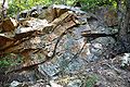
 Unnamed cliff (part of the Alt Cabin Anticline) along Smoke Hole Road
 -
 Exposed rock layers near Big Bend Campground
 -
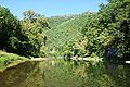 A view of the South Branch at Big Bend
 -
 Blue Rock, composed of the Late Silurian Tonoloway Formation limestone, in the lower Smoke Hole Canyon
 -
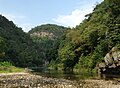 Redman Gap and the South Branch
 -
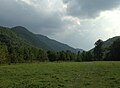 Bottomland in the lower Canyon (looking upstream)


Ecology
Smoke Hole is a biologically diverse area classified as an upland limestone-based ecosystem. It is believed that the Canyon is the largest area of limestone forest left in this region of the country. Most of the forest soil in West Virginia is naturally acidic, only growing a certain range of plants. But limestone soil is not acidic and tends to be richer in certain nutrients than are other soils, thus supporting a different type of plant life. The plant species mix is unique: common Appalachian plants along with prairie species such as
The dry, prairie-like areas along the upper knobs and ridges of the Canyon are home to a variety of typically western plants such as prairie flax. These plants are more commonly found west of the Mississippi River. Due to the protective effect of surrounding mountains, rainfall in Smoke Hole is unusually light — only about 30-32 inches per year. This relatively low precipitation permits a small haven for these unusual species.
About a dozen species of plants and animals in Smoke Hole Canyon are considered to be "globally rare".
Flora

Trees
The dominant trees covering the Canyon's wooded slopes are
Shrubs
The understory of the Canyon woodland includes such low-lying, fruit-bearing vegetation as
Herbs and wild flowers
The biological richness of Smoke Hole's plant communities was demonstrated by a botanist in 1933 who documented 283 species of flora on the 4-acre Hermit Island alone.
The prairie-like regions and associated cedar glades around the Smoke Hole Canyon are the largest groupings of such habitats in the Central Appalachians, and a number of unusual
Fauna
Mammals
The populations of
Today the Canyon still has significant
Birds
The Canyon is a prime area for neotropical migrant birds — i.e., those that spend their summers in the US but migrate to South America for the winter.
Others
The South Branch in Smoke Hole is home to
Rare species of butterfly (
-

-
 Fruit of common pawpaw (Asimina triloba) in the lower Canyon
 -
 Juvenile Virginia opossum
 -
 Crayfish in South Branch Potomac River
 -
 Mating grasshoppers
 -
 Pipevine swallowtail
 -
 Unidentified caterpillar
 -
 Monarch butterflycaterpillars
 -

-
 Beaver handiwork in the lower gorge


Invasive species
An Asian grass known as Japanese stiltgrass was accidentally introduced into the U.S. during the last half of the 20th century and has become a major conservation nuisance nationwide. In recent years, the Canyon has been overwhelmed with this invasive species, first introduced into the state in 1980. The 1996 flood in the Eastern Panhandle of West Virginia spread the seed throughout Smoke Hole, and now it is the most abundantly growing plant in the area. When introduced into a new area, stiltgrass blankets the ground and suffocates other plant life that would ordinarily grow close to the ground. Unchecked, the plant can spread in a manner almost impossible to abate.
Another biological threat to the Canyon is the insect known as
Two other non-native, invasive plants seriously threaten the rare limestone plant communities in the Canyon —
Recreation

Popular activities in Smoke Hole Canyon include fishing (rainbow and golden trout; largemouth and smallmouth bass), hunting (squirrel, grouse, turkey, deer, rabbit and bear), hiking, rock climbing, caving, canoeing and camping (Big Bend Campground).
Boating
Campgrounds
Big Bend Campground is located on a peninsula in the river and features 46 sites with hot and cold water and flush toilets from April 15 to Oct. 1. Hot showers are also provided. Group camping is also available at the Jess Judy Camping Area along the river.
Hiking
The only maintained trail strictly within the Smoke Hole gorge is the 3.5-mile South Branch Trail, a loop trail starting at river level from the FS picnic area (now abandoned). The blue-blazed trail follows the river upstream, ascends part way up Cave Mountain, passes fields and old farms on its way back downstream, and then drops back down to the river nearly opposite Shreve's Store.
The best hiking in the immediate area is undoubtedly the 24-mile-long North Fork Mountain Trail. This stretches along the crest of
Climbing
There are many opportunities for rock climbing in the canyon, from the walls just inside the Route 220 entrance, to soaring Eagle Rocks, to the shaded walls of Long Branch, the steep stiff routes of Sanctuary and the miles of cliffs lining the west face of North Fork Mountain which can be accessed from trailheads on the canyon rim.
This section needs expansion. You can help by adding to it. (August 2014) |
In popular culture
A 2010 documentary film — The Search for Dillinger's Gold, directed by Cam Lemley — alleged that infamous gangster John Dillinger (1903–1934) buried three boxes of gold bullion in a cave somewhere in the Canyon. A man from Oklahoma, claiming to have been a member of Dillinger's gang, hired a local in 1965 to help him locate the legendary loot.[38] Lemley travels no fewer than eight times into the Canyon in search of the swag, estimated to be worth about $10 million. Traveling with other campers and adventurous treasure seekers, the film takes the viewer through raging rapids, unexplored mountain caves, and encounters with wilderness and wildlife native to the region. (Other locations rumored to contain the booty include Mercer, Wisconsin[39] and a farm in northeastern Ohio.[40])
See also
- Smoke Hole Caverns, located just outside the Canyon, in Hopeville Gorge
References
Citations
- 1850 United States Census references residents living in "The Smoke Holes" of Pendleton County, Virginia.
- ISBN 0403021979. Retrieved 2015-07-02.
- ^ McColloch, Jane S. (1986, revised edition), Springs of West Virginia, West Virginia Geological and Economic Survey, pg 284.
- ^ Dasher, George R. (2001), The Caves and Karst of Pendleton County, West Virginia Speleological Survey Bulletin #15, pp 117-118.
- ^ Calhoun, H.M. Sr., "Hermit Island", The West Virginia Review, 6:12, Sept 1929, pg 458.
- ^ Calhoun, H.M. Sr. (6 November 1930), "Tales of Historic Smoke Hole and Seneca Rocks Interestingly Told", from a column in The Herald of Franklin, West Virginia; Reprinted (pp 175-180) in: Shreve, D. Bardon (2005), Sheriff from Smoke Hole (and Other Smoke Hole Stories), Fredericksburg, Virginia: The Fredericksburg Press, Inc.
- ^ Calhoun, H.M. Sr. (1 November 1929), "Tales of the Smoke Hole"; Reprinted (pp 151-153) in: Shreve, (2005).
- ^ West Virginia Writers Project (1940), Smoke Hole and Its People: A Social-Ethnic Study; Charleston, West Virginia: State Department of Education; Reprinted (pp 101-132) in: Shreve, D. Bardon (2005), Sheriff from Smoke Hole (and Other Smoke Hole Stories), Fredericksburg, Virginia: The Fredericksburg Press, Inc, pg 114.
- ^ National Archives and Records Administration. U.S. Pensioners, 1818–1872 Record for William Eagle - PRIVATE
- Valley Forge and Yorktown. All traces of his grave were lost until around 1930 when the USFS found it during a survey. A new white marble stone was dedicated by a descendant on 30 May 1930.
- ^ Calhoun, H.M. Sr. (13 November 1930), "Tales of Historic Smoke Hole and Seneca Rocks Interestingly Told", from a column in The Herald of Franklin, West Virginia; Reprinted (pp 180-183) in: Shreve, D. Bardon (2005).
- ^ Swiger, C.W. "I Discover the Smoke Hole", The West Virginia Review, 8:1, Oct 1930, pg 24. (Details a visit to Smoke Hole in spring 1930.)
- ^ Shreve, D. Bardon, with Estyl C. Shreve (1997), A Place Called Smoke Hole, Fredericksburg, Virginia: Fredericksburg Press, pg 16.
- ^ Shreve (1997), Op. cit., pg 2.
- ^ The first trustees were Alfred Kimble, Jacob L. Kimble, J.H. Lantz, Abraham Kile, and Isaac Ault. This historic building was purchased by the Episcopal Church in 1930 and renamed St. George's Church; it was rededicated in 1966.
- ^ Davies, W.E., (1949), Caverns of West Virginia; State of West Virginia: West Virginia Geological and Economic Survey (Series: Geological and Economic Survey, Volume XIX. A.); 1958 revision, pg 207.
- ^ Calhoun, H.M. Sr. (19 November 1931), column in The Herald of Franklin, West Virginia; Reprinted (pp 140-141) in: Shreve (2005).
- ^ Shreve (1997), Op. cit., pg 36.
- ^ Calhoun, H.M. Sr., (1926), "A Trip through Smoke Hole"; West Virginia Review, October issue.
- ^ Shreve (1997), Op. cit., pp 175-188.
- ^ West Virginia Writers Project (1940), Op. cit., pp 120-121.
- ^ West Virginia Writer's Project (1941), Op. cit., pp 344-355.
- ^ West Virginia Writers Project (1940), Op. cit., pp 128-129.
- ^ West Virginia Writer's Project (1941), Op. cit., pg 347.
- ^ Shreve (1997), Op. cit., pg 122.
- ^ Monongahela National Forest Land and Resource Management Plan
- ^ Steelhammer, Rick (2009-03-14). "Funds given to conserve Grant woodlands". Archived from the original on 2009-03-15. Retrieved 2009-03-14.
- The Charleston Gazette@ WVGazette.com.
- ^ "American Whitewater".
- ^ Sites, Roy S. (2005), “The Smoke Hole Region of West Virginia” at the West Virginia Geological and Economic Survey website.
- ^ a b Sites, Op. cit.
- passim.
- ^ Dasher, George R. (2010), The Caves and Karst of Grant County, West Virginia, West Virginia Speleological Survey, Bulletin #17, passim.
- ^ West Virginia Writers Project (1940), Op. cit., pp 107-108.
- ^ a b c West Virginia Writers Project (1940), Op. cit., pg 108.
- ^ Shreve, D. Bardon, with Estyl C. Shreve (2000), More About Smoke Hole, Fredericksburg, Virginia: Fredericksburg Press, pp 129-130.
- ^ West Virginia Writers Project (1940), Op. cit., pp 108-109.
- ^ Lemley, Cam (2010). Dillinger's Gold.
- ^ Gibson, Corey (August 3, 2013). "10 Real-Life Hidden Treasures you Could Stil Find". Listverse. Retrieved 19 May 2016.
- ^ Yocum, Robin (February 23, 1988). "Dillinger Gang's Buried Loot Still an Alluring Legend". Chicago Tribune. Retrieved 19 May 2016.
Other sources
- This article contains information that originally came from US Government publications and websites and is in the public domain.
- United States Department of Agriculture, Smoke Hole Area Guide: Spruce Knob–Seneca Rocks National Recreation Area, Monongahela National Forest (SuDoc A 13.36/2:SM 7/2).
- Gray, Michael G (2014), A Climbers' Guide To Smoke Hole Canyon, Self-published
- Local history:
- Shreve, D. Bardon, with Estyl C. Shreve (1997), A Place Called Smoke Hole, Fredericksburg, Virginia: Fredericksburg Press.
- Shreve, D. Bardon, with Estyl C. Shreve (2000), More About Smoke Hole, Fredericksburg, Virginia: Fredericksburg Press.
- Shreve, D. Bardon (2005), Sheriff From Smoke Hole (and other Smoke Hole Stories), Fredericksburg, Virginia: Fredericksburg Press.