
St. Kliment Ohridski Base
St. Kliment Ohridski Station | |
|---|---|
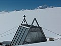
 The Bulgarian base in 2012, with the new St. Ivan Rilski Chapel in the foreground and Russian Hut, Lame Dog Hut (painted light green), the Laboratory, Casa España and the Main Building in the background | |
 St. Kliment Ohridski Station Location of St. Kliment Ohridski Station in Antarctica | |
| Coordinates: 62°38′27″S 60°21′53″W / 62.6409284°S 60.3646792°W | |
| Country | |
| Location in Antarctica | Livingston Island South Shetland Islands |
| Administered by | Bulgarian Antarctic Institute |
| Established | 29 April 1988 |
| Elevation | 15 m (49 ft) |
| Population (2017)[1] | |
| • Summer | 22 |
| • Winter | 0 |
| Type | Seasonal |
| Period | Summer |
| Status | Operational |
| Activities | List
|
| Website | http://www.bai-bg.net |
| Bulgaria in Antarctica |
|---|
|
St. Kliment Ohridski Base (Bulgarian: База Св. Климент Охридски, romanized: Baza Sv. Kliment Ohridski, IPA: [ˈbazɐ svɛˈti ˈklimɛnt ˈɔxritski]) is a Bulgarian Antarctic base on Livingston Island in the South Shetland Islands.
The base, originally known as Sofia University Refuge or Hemus Base,[2] was named in 1993 for medieval Bulgarian scholar St. Clement of Ohrid (840–916).[3] The name is often shortened by non-Bulgarians to Ohridski Base,[4] and sometimes misspelled as Ohridiski.
Location
The base is located at an elevation of 12 to 15 m on Bulgarian Beach, 130 m inland from the shore of Emona Anchorage, between Pesyakov Hill and Sinemorets Hill, overlooking the Grand Lagoon. The base area is crossed by the melt-water Rezovski Creek in the summer, providing a water supply.
History
Following an unsuccessful landing attempt at Cape Vostok on the northwestern extremity of Alexander Island, two prefabricated huts—the Lame Dog Hut and Russian Hut—were assembled on Livingston Island between 26 and 28 April 1988 by a four-member Bulgarian party supported logistically by the Soviet Research Ship Mikhail Somov under Captain Feliks Pesyakov. The facilities were later refurbished and inaugurated as a permanent base on 11 December 1993.[2]
An expansion programme at St. Kliment Ohridski including the construction of a new multi-purpose building was carried out between 1996 and 1998 and subsequently. The
The base is visited regularly by representatives of the institutions responsible for Bulgaria's activities in Antarctica, including President Georgi Parvanov of Bulgaria in January 2005.[2]
Description
Personnel and cargo from supply ships are offloaded by Zodiac boats at the southwestern extremity of the beach, 300 m away from the main base facilities. A designated helipad site is located on the northern side of the Grand Lagoon.
St. Kliment Ohridski enjoys the exceptional advantage of several convenient overland routes leading from Bulgarian Beach to a variety of internal and coastal areas of Livingston Island including the Balkan Snowfield, Burdick Ridge and Pliska Ridge, Tangra Mountains and the glaciers Perunika, Huntress, Huron and Kaliakra, and Saedinenie Snowfield. The Spanish base Juan Carlos I is situated 2.7 km to the south-southwest, and is reached either by sea or by a 5.5 km route, while the central location of Camp Academia site is 11 km due east in the Tangra Mountains.
The base is used by scientists from Bulgaria and other nations for research in the field of
See also

- List of Antarctic research stations
- List of Antarctic field camps
- Lame Dog Hut
- St. Ivan Rilski Chapel
- Bulgarian Antarctic Institute
- Camp Academia
- Livingston Island
- South Shetland Islands
- Antarctica
- Antarctic Place-names Commission
- Tangra 2004/05 Expedition
- Crime in Antarctica
Maps

- Isla Livingston: Península Hurd. Mapa topográfico de escala 1:25 000. Madrid: Servicio Geográfico del Ejército, 1991.
- L.L. Ivanov. St. Kliment Ohridski Base, Livingston Island. Scale 1:1000 topographic map. Sofia: Antarctic Place-names Commission of Bulgaria, 1996. (The first Bulgarian Antarctic topographic map, in Bulgarian)
- L.L. Ivanov et al. Antarctica: Livingston Island and Greenwich Island, South Shetland Islands (from English Strait to Morton Strait, with illustrations and ice-cover distribution). Scale 1:100000 topographic map. Sofia: Antarctic Place-names Commission of Bulgaria, 2005.
- L.L. Ivanov. Antarctica: Livingston Island and Greenwich, Robert, Snow and Smith Islands. Scale 1:120000 topographic map. Troyan: Manfred Wörner Foundation, 2009. ISBN 978-954-92032-6-4
- Bulgarian Base (Sheet 1 and Sheet 2): Antarctica, South Shetland Islands, Livingston Island. Scale 1:2000 topographic map. Sofia: Military Geographic Service, 2016. (in Bulgarian, map images on slides 6 and 7 of the linked report)
- Antarctic Digital Database (ADD). Scale 1:250000 topographic map of Antarctica. Scientific Committee on Antarctic Research (SCAR). Since 1993, regularly upgraded and updated.
- L.L. Ivanov. ISBN 978-619-90008-3-0
Gallery
-
 Bulgarian base in 2003
 -
 Main Building with Friesland Ridge in the background
 -
 The old St. Ivan Rilski Chapel
 -
 Cyrillic Script Monument
 -
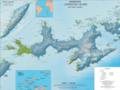 Topographic map of Livingston Island with the bases and base camps on the island
 -
 Base area and facilities in 1996
 -
 Base area and facilities in 2014


References
- ^ ISBN 978-0-473-40409-3. Archived(PDF) from the original on 22 October 2022. Retrieved 16 January 2023.
- ^ ISBN 978-954-07-3939-7
- Composite Antarctic Gazetteer.
- Composite Antarctic Gazetteer
- ^ L. Ivanov. Bulgarian mail services on Livingston Island (1995/96 and 2004/05 seasons). Sofia, March 2005
- ^ Certificate of the Livingston Island Museum. National Museum of History, Sofia, October 2012.
- ^ ATCM Measure V (2015). Annex: Revised List of Historic Sites and Monuments. ATCM Sofia, 1–10 June 2015. pp. 21–42.
- ^ Proposal to add the Lame Dog Hut at the Bulgarian base St. Kliment Ohridski on Livingston Island to the List of Historic Sites and Monuments. Working Paper CEP WP017. ATCM Sofia, 1–10 June 2015.
- ^ Bulgaria successfully completed the Chairmanship of the XXXVIII Antarctic Treaty Consultative Meeting. Ministry of Foreign Affairs of Bulgaria website, 10 June 2015.
- ^ B. Lazarov. The Three Monuments of the Cyrillic Alphabet. Archived 2019-03-27 at the Wayback Machine EUSCOOP News from Bulgaria, 13 March 2018
External links
- Antarctic Place-names Commission of Bulgaria
- Bulgarian Antarctic Institute
- (in Spanish) Spanish Antarctic Base Juan Carlos I
- COMNAP Antarctic Facilities (Archived April 24, 2008, at the Wayback Machine)
- COMNAP Antarctic Facilities Map (Archived September 15, 2009, at the Wayback Machine)
Bibliography
- J. Stewart. Antarctica: An Encyclopedia. Jefferson, N.C. and London: McFarland, 2011. 1771 pp. ISBN 978-0-7864-3590-6
- L. Ivanov and N. Ivanova. St. Kliment Ohridski base. In: The World of Antarctica. Generis Publishing, 2022. pp. 158-162. ISBN 979-8-88676-403-1

This article includes information from the Antarctic Place-names Commission of Bulgaria which is used with permission.