
World Ocean Atlas
The World Ocean Atlas (WOA) is a
World Ocean. It was first produced in 1994[1] (based on the earlier Climatological Atlas of the World Ocean, 1982[2]), with later editions at roughly four year intervals in 1998, 2001, 2005, 2009, 2013, 2018, and 2023.[3]
Dataset
The fields that make up the WOA dataset consist of
sea surface height
.
In addition to the averaged fields of ocean properties, the WOA also contains fields of statistical information concerning the constituent data that the averages were produced from. These include fields such as the number of data points the average is derived from, their standard deviation and standard error. A lower horizontal resolution (5°) version of the WOA is also available. The WOA dataset is primarily available as compressed ASCII, but since WOA 2005 a netCDF version has also been produced.
Gallery
-
 Annual mean sea surface temperature (WOA 2009)
 -
 Annual mean sea surface salinity (WOA 2009)
 -
 Annual mean sea surface dissolved oxygen (WOA 2009)
 -
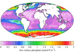 Annual mean sea surface phosphate (WOA 2009)
 -
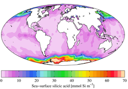 Annual mean sea surface silicic acid (WOA 2009)
 -
 Annual mean sea surface nitrate (WOA 2009)
 -
 Annual mean apparent oxygen utilization at 1000 m depth (WOA 2009)


See also
- CORA dataset
- European Atlas of the Seas
- Geochemical Ocean Sections Study (GEOSECS)
- Global Ocean Data Analysis Project (GLODAP)
- World Ocean Circulation Experiment (WOCE)
References
- ^ "World Ocean Atlas 1994 series". National Oceanographic Data Center. 2008-08-29. Retrieved 2008-10-22.
- ^ Levitus, S. (1982). Climatological Atlas of the World Ocean. NOAA/ERL GFDL Professional Paper 13, Princeton, N.J. p. 173 pp.
- ^ "World Ocean Atlas". National Oceanographic Data Center. Retrieved 2023-01-14.
- ^ Standardised intervals are at 0, 10, 20, 30, 50, 75, 100, 125, 150, 200, 250, 300, 400, 500, 600, 700, 800, 900, 1000, 1100, 1200, 1300, 1400, 1500, 1750, 2000, 2500, 3000, 3500, 4000, 4500, 5000, 5500 m

