
Zalishchyky
Zalishchyky
Залiщики | |
|---|---|
 | |
|
UTC+3 (EEST) | |
 |
Zalishchyky (/zɑːliʃˈtʃiːki/; zaw-leesh-chee-kee; Ukrainian: Залiщики; Polish: Zaleszczyki[1]), also spelled Zalischyky, is a small city located on the Dniester River in Chortkiv Raion, Ternopil Oblast, western Ukraine. It hosts the administration of Zalishchyky urban hromada, one of the hromadas of Ukraine.[2] Population: 8,928 (2022 estimate).[3]
Etymology
Zalishchyky's name, as well as its precursors Zalissia and Zalishche, probably derives from "zalis", a compound of the Ukrainian words "за" (za) and "ліс" (lis), together meaning "behind (the) forest".[4] Hinterwalden, the name for a Saxon settlement in Zalishchyky, also shares this etymological root, originating from the German "hinterwald" (itself meaning, literally, "behind forest").
Others theorise the name derives from the Ukrainian word for the hazel plant (Ukrainian: ліщи́на, romanized: lishchyna), which they attribute to Zalishchyky's initial settlers.[citation needed]
Geography
Zalishchyky is located at the southern edge of
Zalishchyky's climate is quite mild, with grapes, peaches and other fruits growing in the area. It is especially famous for its tomatoes. Since the inter-war era, it has been a centre for the tourist industry. Before the collapse of the
History
While the first known mention of Zalishchyky is traced back to 1340,
During the 19th century, the area around Zalishchyky was populated primarily by Ukrainian country folk, though the town had a large Polish and Jewish population. By then, the city was associated with the best peaches, plums and grapes in the Austrian Empire. On 18 June 1809, during the War of the Fifth Coalition, the town was the site of a fierce battle (Polish: Bitwa pod Zaleszczykami) that ended with an Austrian victory. In 1838, the commander of Zalishchyky's infantry battalion reported the beginnings of a peasant revolt against the didych (Ukrainian: дідичів), the land owners.[7] No battles or skirmishes actually occurred during this "revolt", instead peasants went on strike and lodged complaints to the district council from the government. The Austrian government took many measures to suppress the peasant discontent, and finally in July 1838 evacuated the district administration and started a riot in Zalishchyky, all the while torturing innocent civilians.[5] In 1863, the town's Christians rioted against the Jewish population after a Jewish business owner attempted to collect on a loan to a Christian storekeeper. In the ensuing chaos, Jews were beaten and Jewish property was destroyed before police from Chernivtsi were able to suppress the incident. Later that same year a Jewish family was butchered in a nearby hamlet. Zalishchyky's synagogue was destroyed in 1871 by a massive fire that also razed 170 houses. At the end of the 19th century, the area around Zalishchyky witnessed large-scale emigration to the New World, especially western Canada.

In 1914, Russia captured Zalishchyky, initially killing 30 Jews, before expelling the rest of the town's Jews on 15 April of the following year, many of whom died of
Zalishchyky became part of the

Zalishchyky's already prolific reputation in the world of tourism coupled with the luxtorpeda railways revived Zalishchyky's tourist industry, and the town's economy boomed as it slowly became completely oriented to tourist activity. This bloom lasted until 1939 when Germany commenced the
After Soviet capture and occupation of Zalishchyky, the beaches and orchards were destroyed, the Baroque town hall was demolished, and a monument of
In early July 1941, on a date not certainly known, the Soviets drowned close to a thousand civilians in the Dniester in what became the Zalishchyky tragedy. On 8 July 1941, German forces entered Zalishchyky and immediately began persecuting the town's Jews – more than 3,700 civilians from Zalishchyky and the surrounding locales were murdered.[5] Many were sent to be slave labor in Nazi-controlled Zhvanets in the fall. On 14 November, several Jews were deported to work camps, 200 to Kamianka-Buzka, and 40 to numerous smaller locales, such as Kutno. Shortly after, 800 Jews were forced to the outskirts of Zalishchyky, where they were murdered. In 2011, a monument was erected near the execution site (now a sports stadium). The proper site of the execution was developed with residential houses and garages after the end of the Second World War.
Much of the town died of hunger and typhoid in the winter of 1941, and Jews were moved to neighboring ghettos, mainly to
In March 1944, the region was liberated by the Russians, before briefly returning to German control, during which many Jews were murdered by the panicking Nazis. After being liberated a second time by the
After the war, the town was largely repaired, as industrial plants, buildings, and roads were rebuilt and recommissioned. In addition, canneries were widely re-established, leading to the opening of bakeries, dairy plants, corn-calibrating plants, as well as factories which produced textiles and other consumer goods. Quite a few of these industries lasted until the fall of the Soviet Union, after which they collapsed following the Ukraine's transition from the Soviet planned economy. Nonetheless, the city's economy continues to be concentrated on light industry, particularly the agrarian sector.
In 2016, Zalishchyky celebrated the 250th anniversary of township under the Magdeburg Law with a holiday commemorating the city. A two-day long "Zalishchyky Fest" ensued. Concurrently, Zalishchyky's government has begun work on repairing infrastructure, such as asphalt repair, paved lighting, new lights, benches, litter bins, and a number of improvements to either of the city's local parks; one of which, the Zalishchyky Central Park, houses a number of historic monuments and rare species of flora. This park and Zalishchyky Park which lies to the south are a Ukrainian national park.
Until 18 July 2020, Zalishchyky was the administrative centre of Zalishchyky Raion. The raion was abolished in July 2020 as part of the administrative reform of Ukraine, which reduced the number of raions of Ternopil Oblast to three. The area of Zalishchyky Raion was merged into Chortkiv Raion.[9][10]
Archaeology and monuments
Before the Second World War, the area around Zalishchyky became a major centre of archaeological attention. Near various villages, especially Koshylivtsi (
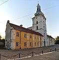
Zalishchyky contains a 17th-century Roman Catholic church, an 18th-century Town Hall and other monuments.
Points of interest
- Roman Catholic Church of St. Stanislaus, founded by the Stanisław II Augustusin 1763, and completed in 1828. The church served as a storage in 1946–1992. Currently, it is under renovation
- The Poniatowski Palace, built in the late 18th century, and remodelled in 1831. It was property of Duke Józef Poniatowski, in the 19th century belonged to the Brunicki family. Its last owners was the Turnau family
- The Pilsudski Villa, where in 1933 Józef Piłsudski stayed
- The 19th century Roman Catholic cemetery
- The manor house of Jan Kasprowicz, a Polish poet who lived here in 1896–1899
Gallery
-
 Roman Catholic Church of St. Stanislaus
 -
 City park and bridges over the Dniester.
 -
 Office buildings in Zalishchyky
 -
 Bruniste Palace
 -
 Ruins of the fire-gutted synagogue


Notable people
- Mykhailo Orest Haivoronsky — Ukrainian composer, musician, conductor, teacher, violinist, and critic
- Lviv University
- Marshal and sixth president of Finlandwas in the town during the First World War
International relations
Twin towns – Sister cities
Zalishchyky is
References
- ISBN 0313260079.
- ^ "Залищицкая городская громада" (in Russian). Портал об'єднаних громад України.
- ^ Чисельність наявного населення України на 1 січня 2022 [Number of Present Population of Ukraine, as of January 1, 2022] (PDF) (in Ukrainian and English). Kyiv: State Statistics Service of Ukraine. Archived (PDF) from the original on 4 July 2022.
- ^ (in Ukrainian) Тернопільський енциклопедичний словник / редкол.: Г. Яворський та ін. — Тернопіль: видавничо-поліграфічний комбінат «Залiщики», 2004–2010. — Т. 1, p. 608 (Ternopil Encyclopedic Dictionary, Vol. 1, p. 608)
- ^ a b c d e Історія міст і сіл Української РСР Vol. 20, pp. 252–261
- ISBN 5-203-01639-9.
- ISBN 5-7773-0359-5.
- ^ "Zaleszczyki". sztetl.org.pl. Archived from the original on 3 June 2016.
- ^ "Про утворення та ліквідацію районів. Постанова Верховної Ради України № 807-ІХ". Голос України (in Ukrainian). 18 July 2020. Retrieved 3 October 2020.
- ^ "Нові райони: карти + склад" (in Ukrainian). Міністерство розвитку громад та територій України.
- ^ "Miasta Partnerskie". Bytów City Council Official Site (in Polish). Archived from the original on 3 May 2013. Retrieved 22 June 2013.
General references
- Hryniuk, Stella Peasants with Promise: Ukrainians in Southeastern Galicia 1880–1900 (Edmonton, 1991). Contains a map on the endpapers of the book which shows all of the villages of this part of Galicia, including the Zalishchyky area.
- Przewodnik po Województwie Tarnopolskiem z mapą [Guide to the Ternopil Region with a Map] (Ternopil, 1928: reprinted circa 1990). Contains much historical material.
External links
- Web site of photo & video archive of Zalishchyky, Ukraine
- Web site of Zalishchyky, Ukraine
- History of Zalishchyky
| International | |
|---|---|
| National | |
| Other | |