
Ayrshire
Ayrshire
Siorrachd Inbhir Àir ( Scottish Gaelic) | |
|---|---|
 | |
| Country | Scotland |
| County town | Ayr |
| Area | |
| • Total | 1,129 sq mi (2,924 km2) |
| Ranked 7th of 34 | |
| Chapman code | AYR |
Ayrshire (
The electoral and valuation area named Ayrshire covers the three council areas of East Ayrshire, North Ayrshire and South Ayrshire, therefore covering the whole historic county of Ayrshire but also including the Isle of Arran, Great Cumbrae and Little Cumbrae from the historic county of Buteshire. The three council areas together also form the Ayrshire and Arran lieutenancy area.
The largest settlement in Ayrshire by population is Kilmarnock, closely followed by Ayr, the county town.
Geography
Ayrshire is roughly crescent-shaped and is a predominantly flat county with areas of low hills; it forms part of the
Southern Ayrshire shares with the Galloway counties some rugged hill country known as the Galloway Hills. These hills lie to the west of the A713 (Ayr to Castle Douglas road) and they run south from the Loch Doon area almost to the Solway Firth. To the east of this route through the hills lie the Carsphairn and Scaur Hills which lie to the south east of Dalmellington and south of New Cumnock. Glen Afton runs deep into these hills.
Ayrshire is one of the most agriculturally fertile regions of Scotland. Potatoes are grown in fields near the coast, using seaweed-based fertiliser, and in addition the region produces pork products, other root vegetables, and cattle (see below);[1] and summer berries such as strawberries are grown abundantly.
A number of small islands in the Firth of Clyde are part of Ayrshire, the chief of these being Horse Isle, Lady Isle and Ailsa Craig.
Rivers
The main rivers flowing to the Clyde coast are, from north to south, the following:
- River Garnock
- River Irvine
- River Ayr
- River Doon
- River Girvan
- River Stinchar
-
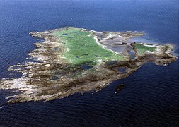 Horse Isle
 -
 Part of Ayr Beach with the Heads of Ayr in the background
 -
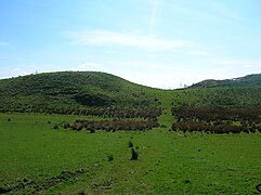 Boyd's Hill near Dunlop
 -
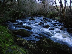 The Garnock's Waters near Glengarnock Castle
 -
 Mochrum Hill near Kirkoswald
 -
 Lendalfoot coast, with Ailsa Craig in the distance
Jun2004.jpg)


History
The area that today forms Ayrshire was part of the area south of the Antonine Wall which was briefly occupied by the Romans during the reign of Emperor Antoninus Pius (see: Roman Britain#Occupation and retreat from southern Scotland). It was inhabited by the Damnonii, who are presumed to have been Britons. Later, it formed part of the British Kingdom of Strathclyde, which was incorporated into the Kingdom of Scotland during the 11th century. In 1263, the Scots successfully drove off the Norwegian leidang-army in a skirmish known as the Battle of Largs.

A notable historic building in Ayrshire is
The historic
- Carrick in the south. It was situated between the Doon and the wild district of Galloway in the adjoining Stewartries, an area that was little else than a vast tract of hills and mosses.[2]
- Kyle in the centre, which included the royal burgh of Ayr, occupied the central district between the River Irvine in the north, and the River Doon in the south and south-west, an area that is quite hilly inland. It was subdivided into "Kyle Stewart",[3] (sometimes called "Stewart Kyle"[2] or "Walter's Kyle"[4]) and "King's Kyle," the former embracing the country between the Irvine and the River Ayr; and the latter, the triangular portion between the Ayr and the Doon, which is honoured as the birthplace and youthful home of Robert Burns.[2]
- Cunninghame in the north which included the royal burgh of Irvine was that part of the county which lay north of the Irvine water, and was in an area that is generally level and fertile.[2]
The area used to be heavily industrialised, with
Throughout the 17th century, huge numbers of people from Ayrshire moved to Ulster, the northern province in Ireland, as part of the Plantation of Ulster, many of them with surnames such as Burns, Hamilton, Morrow, Stewart, Flanagan, Kennedy and Cunningham. Today, the Ulster Scots dialect is largely an offshoot of the version of Lowland Scots spoken in Ayrshire. The Ulster Scots dialect is still widely spoken throughout County Antrim and in parts of County Down and County Londonderry, as well as still being widely spoken in West Tír Eoghain and parts of County Donegal (chiefly East Donegal and Inishowen).
Local government


In 1930 the
In May 1975 the county council was abolished and its functions were transferred to
In 1996 the two-tier system of
The boundaries of the historic county of Ayrshire are still used for some limited official purposes connected with land registration, being a registration county.[13]
Parliamentary constituencies
There was an
During the whole of the 1708 to 1868 period, and until 1950, the
From 1918 to 1983 Ayrshire and
Constituencies covering Ayrshire may be listed by periods as below, but the story is somewhat more complicated than the lists may imply: until 1918, Ayr Burghs and Kilmarnock Burghs included burghs lying outside both Ayrshire and Buteshire; a particular constituency name may represent different boundaries in different periods; in 1974, there were boundary changes without the creation of any new constituency names.[citation needed]
| Period | Constituencies |
|---|---|
| 1708 to 1832 | Ayrshire and Ayr Burghs |
| 1832 to 1868 | Ayrshire, Kilmarnock Burghs and Ayr Burghs |
| 1868 to 1918 | North Ayrshire, Kilmarnock Burghs, Ayr Burghs and South Ayrshire |
| 1918 to 1950 | Bute and Northern Ayrshire, Kilmarnock, Ayr Burghs and South Ayrshire |
| 1950 to 1983 | Bute and Northern Ayrshire, Central Ayrshire, Kilmarnock, Ayr and South Ayrshire |
Transport
_-_geograph.org.uk_-_554287.jpg)
A number of railway lines connect the towns of northern Ayrshire to each other and also to Glasgow, as well as south to Stranraer and south-east to Dumfries.
Ferries link Ayrshire to the islands of
Towns and villages in Ayrshire
.jpg)


- Alloway
- Ardrossan
- Annbank
- Ardeer
- Auchentiber
- Auchinleck
- Ayr
- Ballantrae
- Barassie
- Barkip
- Barr
- Barrhill
- Barrmill
- Beith
- Bellsbank
- Belmont
- Benslie
- Bourtreehill
- Broomlands
- Burnhouse
- Catrine
- Colmonell
- Coylton
- Craigie
- Craigmalloch
- Cronberry
- Crosshill
- Crosshouse
- Cumnock
- Cunninghamhead
- Dailly
- Dalgarven
- Dalmellington
- Dalry
- Dalrymple
- Darvel
- Doonfoot
- Drakemyre
- Dreghorn
- Drongan
- Drybridge
- Dundonald
- Dunlop
- Dunure
- Fairlie
- Fenwick
- Fergushill
- Fullarton
- Galston
- Gatehead
- Gateside
- Giffordland
- Girdle Toll
- Girvan
- Glenbuck
- Glengarnock
- Greenhills
- Hansel
- Haugh
- Heathfield
- Hessilhead hamlet
- Highfield
- Hurlford
- Irvine
- Joppa
- Kilbirnie
- Kilmarnock
- Kilmaurs
- Kilwinning
- Kincaidston
- Kirkmichael
- Kirkoswald
- Knockentiber
- Largs
- Lendalfoot
- Loans
- Logan
- Longbar
- Lugton
- Lugar
- Lylestone
- Mauchline
- Maidens
- Maybole
- Meikle Auchengree
- Minishant
- Monkton
- Moscow
- Montgreenan
- Mossblown
- Muirkirk
- Netherthird
- New Cumnock
- Newmilns
- Ochiltree
- Old Dailly
- Patna
- Pinmore
- Pinwherry
- Polnessan
- Portencross
- Prestwick
- Priestland
- Rankinston
- Riccarton
- Saltcoats
- Seafield
- Seamill
- Skelmorlie
- Sorn
- Springside
- Stair
- Stevenston
- Stewarton
- Straiton
- Symington
- Tarbolton
- Torranyard
- Trabboch
- Troon
- Turnberry
- Waterside
- West Kilbride
Places of interest
- Auchenharvie Castle
- Barony and Castle of Giffen
- Cleeves Cove
- Clyde Muirshiel Regional Park
- Corsehill
- Culzean Castle
- Dalgarven Mill – Museum of Ayrshire Country Life and Costume
- Dean Castle - Kilmarnock
- Eglinton Country Park
- Laigh Milton viaduct
- Thurgartstone
- Ayr Seafront Playpark
- Burns National Heritage Park
- The Low Green, Ayr
- Turnberry (golf course)
People from Ayrshire
- Hew Ainslie (1792–1878), poet[18]
- Nicola Benedetti (1987-), classical violinist born in West Kilbride
- Sir Brisbane is named. Born in Largs.
- John Boyd Orr (1880–1971), Nobel Peace Prize winner, born in Kilmaurs.
- George Douglas Brown (1869–1902), novelist, best known for The House with the Green Shutters, born in Ochiltree
- Robert the Bruce (1274–1329), possibly born in Turnberry Castle
- Robert Burns (1759–1796), poet, born in Alloway
- Kenneth Campbell (1917–1941), RAF pilot and posthumous recipient of the Victoria Cross, born in Ardrossan
- Robert Craufurd (1764–1812), British major general;
- pneumatic tyre, born in Dreghorn
- Robert Dunsmuir (1825-1889), coal baron and industrial capitalist on Vancouver Island, Canada
- Henry Faulds (1843-1930), doctor, missionary and scientist. Born in Beith
- Andrew Fisher (1862–1928), 5th Prime Minister of Australia (1908-1909, 1910–1913 and 1914–1915)
- Sir Alexander Fleming (1881–1955), inventor/discoverer of penicillin, born in Darvel
- John Galt (1779–1839), author
- Men At Work, born in Saltcoats.
- Air Chief Marshal Angus Houston (1947–), current Australian Chief of Defence Force
- .
- Tom Hunter (1961–), entrepreneur and philanthropist
- Jenny Lindsay (1982–), poet
- The X Factor
- Sir James MacMillan (1959-), classical composer and conductor
- John McAdam (1756–1836), engineer and inventor of macadam
- Scottish School of Common Sense and president of what would become Princeton University[18]
- Jai McDowall (1986–), winner of Britain's Got Talent in 2011
- Hugh McIlvanney MBE (1934-2019), Sports Journalist, born in Kilmarnock.
- William McIlvanney (1936–2015), Writer, born in Kilmarnock.
- Sir Thomas McKillop, (1943–) CEO of AstraZeneca, born in Dreghorn
- James Henry McLean (1806–1886), physician and United States Congressman from Missouri[18]
- Whose Line Is It Anyway?, born in Kilmarnock
- William Murdoch (1754–1839), inventor of gas lighting and engineer
- Simon Neil (1979–), James Johnston (1980–), and Ben Johnston (1980–) of Biffy Clyro
- Alexander Peden (1626–1686), leading figure in the Covenanter movement
- Robert Simson (1687–1768), mathematician and professor of mathematics for 50 years
- Elaine Smith (1962–), former actress who emigrated to Australia and found fame on television series Neighbours in 1985 as original character Daphne Clarke.
- Nicola Sturgeon (1970–), former First Minister of Scotland, born in Irvine.
Sport
- Kimberly Benson (1991–), professional wrestler best known as Piper Niven and for her work in WWE and ICW
- Kris Boyd (1983-), Footballer, born in Irvine[20]
- Kirk Broadfoot (1984–), Footballer, born in Irvine[21]
- Craig Burley (1971–), Footballer, born in Ayr[22]
- George Burley (1956–), Footballer, born in Cumnock[23]
- Paul Caddis (1988–), Footballer, born in Irvine[24]
- Eric Caldow (1934–2019), Footballer, born in Cumnock[25]
- Steve Clarke (1963-), Football manager and former player, born in Saltcoats.
- Paul Clarke (1956–), Footballer, born in Ardrossan[26]
- Craig Conway (1985–), Footballer, born in Irvine[27]
- Erin Cuthbert (1998-), Footballer, born in Irvine[29]
- 205 Livebrands
- Billy Dodds (1969–), Football manager and former player, born in New Cumnock[30]
- Kris Doolan (1986–), Football manager and former player, born in Irvine[31]
- Julie Fleeting (1980-), Footballer, born in Kilwinning[32]
- Alan Forrest (1996–), Footballer, born in Irvine[33]
- James Forrest (1991–), Footballer, born in Prestwick[34]
- RAWbrand as Drew McIntyre
- Billy Gilmour (2001–), Footballer, born in Irvine[35]
- Jamie Hamill (1986–), Footballer, born in Irvine[36]
- Garry Hay (1977–), Footballer, born in Irvine[37]
- Jack Hendry (1995–), Footballer, raised in Annbank[38]
- Gary Holt (1973–), Football manager and former player, born in Irvine[39]
- Bobby Lennox, MBE. (1943-), Footballer, born in Saltcoats
- Lou Macari (1949–), Footballer, raised in Largs[40]
- Robby McCrorie (1998–), Footballer, born in Dailly[41]
- Ross McCrorie (1998–), Footballer, born in Dailly[42]
- Alan McInally (1963–), Footballer, born in Ayr[43]
- Rory McKenzie (1993–), Footballer, born in Irvine[44]
- Gordon McQueen (1952–), Footballer, born in Kilbirnie[45]
- Steven Naismith (1986–), Football manager and former player, born in Irvine[46]
- Jamie Ness (1991–), Footballer, born in Irvine[47]
- Steve Nicol (1961–), Footballer, born in Irvine[48]
- Graeme Obree (1965-), Cyclist, raised in Irvine[49]
- Jemma Reekie (1998-), Middle-distance runner, raised in Beith[50]
- Rose Reilly (1955-), Footballer, born in Kilmarnock[51]
- Craig Samson (1984–), Footballer, born in Irvine[52]
- football manager, born in Glenbuck
- Football Manager, born in Glenbuck
- Ryan Stevenson (1984–), Football manager and former player, born in Irvine[53]
- Ross Stewart (1996–), Footballer, born in Irvine[54]
- Gordon Smith (1954–), Footballer, born in Kilwinning[55]
- Sam Torrance (1953–), professional golfer, born in Largs
See also
References
- ^ "Farms in Ayrshire - numbers, types and income: FOI release". www.gov.scot. Scottish Government. Retrieved 26 October 2022.
- ^ a b c d Douglas, William Scott (1874). In Ayrshire; a descriptive picture of the County of Ayr, with relative notes on interesting local subjects, chiefly derived during a recent personal tour. Kilmarnock M'Kie & Drennan. p. 2.
- ^ Chisholm, Hugh, ed. (1911). . Encyclopædia Britannica. Vol. 3 (11th ed.). Cambridge University Press. pp. 74–76.
- ^ Murray, David (1924). Early burgh organization in Scotland: as illustrated in the history of Glasgow and of some neighbouring burghs. Vol. 2. Maclehose, Jackson & Co.
- ^ Shennan, Hay (1892). Boundaries of counties and parishes in Scotland as settled by the Boundary Commissioners under the Local Government (Scotland) Act, 1889. Edinburgh: W. Green. p. 296. Retrieved 30 December 2022.
- ^ Local Government (Scotland) Act 1889, sections 8 and 105
- ^ "Notes on local and current topics". Irvine Herald. 24 January 1890. p. 4. Retrieved 30 December 2022.
- ^ Historic Environment Scotland. "Wellington Square, County Buildings including gates (LB47250)". Retrieved 18 July 2021.
- ^ "Local Government (Scotland) Act 1973", legislation.gov.uk, The National Archives, 1973 c. 65, retrieved 24 December 2022
- ^ "The Lord-Lieutenants Order 1975", legislation.gov.uk, The National Archives, SI 1975/428, retrieved 30 December 2022
- ^ "The Lord-Lieutenants (Scotland) Order 1996", legislation.gov.uk, The National Archives, SI 1996/731, retrieved 30 December 2022
- ^ "Local Government etc. (Scotland) Act 1994", legislation.gov.uk, The National Archives, 1994 c. 39, retrieved 30 December 2022
- ^ "Land Mass Coverage Report" (PDF). Registers of Scotland. Archived from the original (PDF) on 3 March 2016. Retrieved 16 May 2015.
- ^ Cheffins, Richard H. A. "Parliamentary constituencies and their registers since 1832" (PDF). British Library. p. 40.
- ^ glasgowprestwick.com - Destination Map Archived 3 July 2016 at the Wayback Machine retrieved 4 July 2016
- ^ "Elvis anniversary: Blue suede shoes and bobby socks". BBC. 3 March 2010. Retrieved 8 January 2015.
- ^ "Were you there when Elvis landed in Prestwick?". maybole.org.
- ^ a b c Who Was Who in America, Historical Volume, 1607-1896. Chicago: Marquis Who's Who. 1963.
- ^ Euan Robson, George Houston: Nature's Limner (Atelier Books: Edinburgh, 1997).
- ^ "Kris Boyd Profile". www.eurosport.com. Retrieved 14 January 2023.
- ^ "Kirk Broadfoot Profile". www.eurosport.com. Retrieved 14 January 2023.
- ^ "Craig Burley | Scotland | Scottish FA". www.scottishfa.co.uk. Retrieved 14 January 2023.
- ^ "George Burley | Scotland | Scottish FA". www.scottishfa.co.uk. Retrieved 14 January 2023.
- ^ "Paul Caddis Profile". www.eurosport.com. Retrieved 16 January 2023.
- ^ "A tribute to Cumnock's finest player Eric Caldow and his amazing career". Cumnock Chronicle. Retrieved 16 January 2023.
- ^ "Do You Remember ? Paul Clarke 1974-86". www.killiefc.com. Retrieved 16 January 2023.
- ^ "Craig Conway Profile". www.eurosport.com. Retrieved 16 January 2023.
- ^ "Stewarton woman recognised by council for 'enormous contribution' to women's football". Irvine Times. 1 April 2023. Retrieved 21 October 2023.
- ^ "Erin Cuthbert". www.chelseafc.com. Retrieved 21 October 2023.
- ^ "Billy Dodds | Scotland | Scottish FA". www.scottishfa.co.uk. Retrieved 16 January 2023.
- ^ "Kris Doolan Profile". www.eurosport.com. Retrieved 16 January 2023.
- ^ "Top honour for Kilwinning footballer". Ardrossan and Saltcoats Herald. 25 October 2018. Retrieved 21 October 2023.
- ^ "Alan Forrest Profile". www.eurosport.com. Retrieved 14 January 2023.
- ^ "James Forrest Profile". www.eurosport.com. Retrieved 14 January 2023.
- ^ "Billy Gilmour Profile". www.eurosport.com. Retrieved 14 January 2023.
- ^ "Jamie Hamill Profile". www.eurosport.com. Retrieved 16 January 2023.
- ^ "Garry Hay | Former Players". www.killiefc.com. Retrieved 16 January 2023.
- ^ "Jack Hendry: Press-ups before bed has helped me push my way into Celtic and Scotland sides". HeraldScotland. Retrieved 16 January 2023.
- ^ "Gary Holt Profile". www.eurosport.com. Retrieved 16 January 2023.
- ^ "Life and times of Lou Macari". Largs and Millport Weekly News. Retrieved 14 January 2023.
- ^ "Robby McCrorie Profile". www.eurosport.com. Retrieved 16 January 2023.
- ^ "Scotland - R. McCrorie - Profile with news, career statistics and history - Soccerway". uk.soccerway.com. Retrieved 16 January 2023.
- ^ "Scotland - A. McInally - Profile with news, career statistics and history - Soccerway". uk.soccerway.com. Retrieved 14 January 2023.
- ^ "Rory McKenzie Profile". www.eurosport.com. Retrieved 16 January 2023.
- ^ "Gordon McQueen | Scotland | Scottish FA". www.scottishfa.co.uk. Retrieved 14 January 2023.
- ^ "Steven Naismith Profile". www.eurosport.com. Retrieved 14 January 2023.
- ^ "Jamie Ness Profile". www.eurosport.com. Retrieved 16 January 2023.
- ^ "Steve Nicol Profile". www.eurosport.com. Retrieved 14 January 2023.
- ^ "Cycle-pathic: me and my bike, Graeme Obree". The Herald. 3 October 2014. Retrieved 21 October 2023.
- ^ "Beith's Jemma Reekie finishes fourth in Tokyo Olympics 800m". Ardrossan and Saltcoats Herald. 4 August 2021. Retrieved 21 October 2023.
- ^ "ROSE REILLY MBE". Scottish Sports Hall of Fame. Retrieved 21 October 2023.
- ^ "Craig Samson | Former Players". www.killiefc.com. Retrieved 16 January 2023.
- ^ "Scotland - R. Stevenson - Profile with news, career statistics and history - Soccerway". int.soccerway.com. Retrieved 16 January 2023.
- ^ "Scotland - R. Stewart - Profile with news, career statistics and history - Soccerway". uk.soccerway.com. Retrieved 16 January 2023.
- ^ "Gordon Smith Profile". www.eurosport.com. Retrieved 16 January 2023.
External links
| Settlements |  | |
|---|---|---|
| Administration |
| |
| Culture | ||
| Geography | ||
| History | ||
| Sport | ||
| Transport |
| |