
Ross-shire
This article needs additional citations for verification. (December 2011) |
Ross-shire | ||
|---|---|---|
|
Country | ||
| County town | Dingwall | |
| Area | ||
| • Total | 3,089 sq mi (8,000 km2) | |
| Ranked 3rd of 34 | ||
| Chapman code | ROC (as part of Ross and Cromarty) | |
Ross-shire (
For
The
In 1975, Ross and Cromarty was itself replaced by the
There was a Ross-shire constituency of the Parliament of Great Britain from 1708 to 1801, and of the Parliament of the United Kingdom from 1801 to 1832. In 1832 it was merged with the Cromartyshire constituency to form the Ross and Cromarty constituency.
Geography

Western Ross-shire, also known as
The eastern half (Easter Ross) is generally flatter, and consists of towns, villages and farmland bordering the Moray Firth. In the north Dornoch Firth separates the county from Sutherland; near the Dornoch Firth Bridge lies the thin, tapering Ness of Portnaculter peninsula. In the north-east can be found the hammerhead-shaped Tarbat peninsula which is shared with Cromartyshire; across Cromarty Firth lies the Black Isle (actually a peninsula not an island), which is also shared with Cromartyshire. To the south-east Beauly Firth forms the border with Inverness-shire.
The county contains numerous lochs, the most prominent of these being
Lewis is the northern part of Lewis and Harris, the largest island of the Outer Hebrides and the third largest in the British Isles after Britain and Ireland. Due to its flatter, more fertile land, Lewis contains three-quarters of the population of the Western Isles, and the largest settlement, Stornoway. To the west lie the isolated and uninhabited Flannan Isles. About 71 kilometres (44 miles) north of the Butt of Lewis lie North Rona and Sula Sgeir, a remote group of islands which are included within Ross-shire.
Islands
Mainland
- A' Ghlas-Leac
- An Garbh-Eilean
- Black Islands
- Crowlin Islands
- Eilean a' Chait
- Eilean a' Mhal
- Eilean an Inbhire Bhàin
- Eilean an t-Sratha
- Eilean Bàn
- Eilean Chuaig
- Eilean Dubh Dhurinis
- Eilean Furadh Mòr
- Eilean Horrisdale
- Eilean Mòr
- Eilean na Bà
- Eilean na Bà Mòr
- Eilean na Beinne
- Eilean na Creige Duibhe
- Eilean nam Feannag
- Eilean nan Naomh
- Eilean Stacan
- Eilean Tioram
- Eileanan Dubha
- Fraoch Eilean
- Fraoch Eilean Mòr
- Glas Eilean
- Gruinard Island
- Isle of Ewe
- Kishorn Island
- Làrach Tigh Mhic Dhomhnuill
- Longa Island
- Sgeir a' Bhuic
- Sgeir a' Ghair
- Sgeir an Araig
- Sgeir an Fheòir
- Sgeir Bhuide
- Sgeir Bhuidhe
- Sgeir Chreagach
- Sgeir Dùghaill
- Sgeir Fhada
- Sgeir Ghlas
- Sgeir Maol Mhoraidh
- Sgeir Maol Mhoraidh Shuas
- Sgeir na Trian
- Shieldaig Island
- Strome Islands
- Ulluva
Lewis
- Àird Orasaigh
- Bearasaigh
- Bhuaile Mhòr
- Bràighe Mòr
- Bratanais Mòr
- Campaigh
- Ceabagh
- Ceabhaigh
- Cealasaigh
- Cliatasaigh
- Craigeam
- Cruitear
- Cùl Campaigh
- Eilean a' Bhlàir
- Eilean an Tighe
- Eilean Àrnol
- Eilean Beag a' Bhàigh
- Eilean Bhàcasaigh
- Eilean Bhinndealaim
- Eilean Chearstaigh
- Eilean Chalaibrigh
- Eilean Chaluim Cille
- Eilean Cheòis
- Eilean Dubh a' Bhàigh
- Eilean Fir Chrothair
- Eilean Liubhaird
- Eilean Mhealasta
- Eilean Molach
- Eilean Mòr a' Bhàigh
- Eilean Mòr Lacasaidh
- Eilean Mòr Phabail
- Eilean nan Uan
- Eilean Orasaidh
- Eilean Orasaigh
- Eilean Rosaidh
- Eilean Sgarastaigh
- Eilean Shìophoirt
- Eilean Teinis
- Eilean Thinngartsaigh
- Eilean Thòraidh
- Eilean Thuilm
- Eilean Trosdam
- Eughlam
- Eunaigh Mòr
- Flannan Isles
- Fleisgeir
- Flodaigh, Lewis
- Flodaigh (Outer Loch Ròg)
- Fuaigh Beag
- Fuaigh Mòr
- Garbh Eilean
- Geile Sgeir
- Glas Sgeir
- Gousam
- Great Bernera
- Grèineam
- Hairsgeir Beag
- Hairsgeir Mòr
- Lada Sgeir
- Langaisgeir Mòr
- Lewis (part of the larger Lewis and Harris island)
- Linngeam
- Liongam
- Lìth Sgeir
- Little Bernera
- Màs Sgeir
- Pabaigh Beag
- Pabaigh Mòr
- Riosaigh
- Seanna Chnoc
- Sgeir a' Mhurain
- Sgeir Dhail
- Sgeir Dhearg
- Sgeir Ghlas Bheag
- Sgeir Ghobhlach
- Sgeir Leathann
- Sgeir Liath
- Sgeir Mhòr Shildinis
- Sgeir Mol Srupair
- Sgeir Sgianailt
- Sgeir Tanais
- Sgeirean An Arbhair
- Shiant Islands
- Siaram Bostadh
- Siaram Mòr
- Tabhaigh Bheag
- Tabhaigh Mhòr
- Tamna
- Tanaraigh
- Tannaraidh
- Thalta Sgeir
- Vacsay (Bhàcasaigh in Gaelic)
North Rona
-
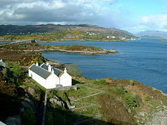 Eilean Bàn from the Skye Bridge, looking towards Kyle of Lochalsh
 -
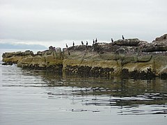 Shag birds on Longa Island
 -
 The Isle of Ewe
 -
 Cave on Garbh Eilean, Shiant Isles
 -
 The famous Callanish Stones on Lewis
 -
 Seana Chnoc (at left) and Bearasaigh from the south west. Stac nam Balg is just visible to the left of Seanna Chnoc


Settlements
Mainland


- Achnasheen
- Alness
- Applecross
- Ardgay
- Aultbea
- Avoch
- Ballintore
- Barbaraville
- Conon Bridge
- Contin
- Culrain
- Diabaig
- Dingwall
- Dornie
- Easter Fearn
- Edderton
- Evanton
- Fearn
- Fortrose
- Garve
- Gairloch
- Hill of Fearn
- Invergordon
- Inverinate
- Kilmuir, Black Isle
- Kilmuir, Easter Ross
- Kinlochewe
- Kyle of Lochalsh
- Laide
- Marybank
- Marburgh
- Muir of Ord
- Mulbuie
- Munlochy
- Nigg
- North Kessock
- Poolewe
- Reraig
- Shieldaig
- Strathcarron
- Strathpeffer
- Stromeferry
- Tain
- Torridon
Isle of Lewis

- Achmore
- Adabrock
- Aignish
- Aird
- Aird Uig
- Airidhbhruaich
- Arnol
- Back
- Balallan
- Ballantrushal
- Barvas
- Borve
- Bragar
- Branahuie
- Brue
- Breaclete
- Breanish
- Breasclete
- Calbost
- Callanish
- Carishader
- Carloway
- Caverstay
- Cliff
- Coll
- Cromore
- Cross
- Crossbost
- Crowlista
- Dalbeg
- Eagleton
- Eorodale
- Eoropie
- Fivepenny
- Flesherin
- Garynahine
- Garyvard
- Geishader
- Gisla
- Gravir
- Gress
- Grimshader
- Habost
- Hacklete
- Holm
- Islivik
- Keose
- Keose Glebe
- Kershader
- Kirkibost
- Kneep
- Knockaird
- Laxay
- Laxdale
- Lemreway
- Leurbost
- Lionel
- Lower Bayble
- Mangursta
- Marvig
- Marybank
- Meavik
- Melbost
- Newmarket
- Newvalley
- North Dell
- North Galson
- North Tolsta
- Orinsay
- Parkend
- Plasterfield
- Portnaguran
- Port of Ness
- Portvoller
- Ranish
- Sandwick
- Shader
- Shawbost
- Sheshader
- Shieldenish
- Shulishader
- Skigersta
- South Dell
- South Galson
- Steinish
- Stornoway
- Swainbost
- Timsgarry
- Tobson
- Tong
- Upper Bayble
- Valtos
See also
- Mormaer of Ross
- Bishop of Ross
- James McKenzie
References
- ^ a b Mackenzie, Sir George Steuart (1810). General View of the Agriculture of the Counties of Ross and Cromarty: With Observations on the Means of Their Improvement. Richard Phillips. pp. 15–16. Retrieved 28 March 2013.; RPS 1685/4/66, RPS 1685/4/67, RPS 1686/4/35, RPS 1690/4/108, RPS 1690/4/119
- ^ "Records of the Parliaments of Scotland". www.rps.ac.uk.
- ^ ISBN 9789004269255. Retrieved 24 April 2017.
- ^ "Records of the Parliaments of Scotland". www.rps.ac.uk.
- ^ a b "Records of the Parliaments of Scotland". www.rps.ac.uk.
External links
- Map of Ross-shire on Wikishire