Bechamoun
This article needs additional citations for verification. (September 2023) |
Bechamoun
Arabic: بشامون | |
|---|---|
 Bechamoun | |
| Coordinates: 33°46′55″N 35°31′52″E / 33.781936°N 35.531131°E |
Bechamoun (
Bechamoun was the first village to raise the Lebanese flag after gaining independence from France.
Name
Bchamoun's name is derived from “Beit Chamoun” (Arabic) The word comes from Syriac Aramaic spoken by the Canaanites. , “House of Chamoun” (English), "Temple of Eshmun" (Syriac Aramaic), a Phoenician god.
Schools
Bchamoun has 10 schools, 8 private and 2 governmental.[1]
Hospitals
There is only one hospital in Bchamoun which is Bchamoun Speciality Hospital.[1]
Geography and Archaeology
Bchamoun is divided to 3 parts.
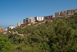
1. Al Day3a zone which is the old village and its three hills surrounded with forests and great views toward Beirut
2. Madares
3. Yanar is a modern city that lies under the hills overlooking the airport and Beirut.
An archaeological site was discovered 6 kilometres (3.7 mi) east of
See also
- Druze in Lebanon
- Christianity in Lebanon
References
- ^ a b Localiban. "Bchamoun - Localiban". www.localiban.org. Retrieved 2022-03-24.
- ^ Lorraine Copeland; P. Wescombe (1965). Inventory of Stone-Age sites in Lebanon, p. 72. Imprimerie Catholique. Retrieved 21 July 2011.[permanent dead link]
External links
- Bchamoun, localiban


