
Interstate 83
| ||
|---|---|---|
| ||
| North end | I-81 / US 322 near Progress, PA | |
| Location | ||
| Country | United States | |
| States | Maryland, Pennsylvania | |
| Counties | MD: City of Baltimore, Baltimore PA: York, Cumberland, Dauphin | |
| Highway system | ||
| ||
Interstate 83 (I-83) is an
Most of the route south of Lemoyne, Pennsylvania, is a direct replacement of U.S. Route 111 (US 111), a former spur of US 11.
Route description
| mi[1] | km
| |
|---|---|---|
| MD | 34.50 | 55.52 |
| PA | 50.53 | 81.32 |
| Total | 85.03 | 136.84 |
Maryland
Jones Falls Expressway

The Jones Falls Expressway (JFX) is a 10.2-mile-long (16.4 km)
The freeway begins at an at-grade, four-way intersection between the JFX, Fayette Street, and
Passing beneath the Orleans Street Viaduct (
_just_south_of_Exit_10_(Northern_Parkway)_in_Baltimore_City,_Baltimore.jpg)
Having passed this curve, the JFX begins to parallel
After interchanging with
At the beltway, I-83 leaves the JFX and joins I-695 for a distance of 1.4 miles (2.3 km), where it separates from the latter route to continue onward into northern Maryland. Meanwhile, the JFX continues for another 0.5 miles (0.80 km) in a four-lane divided format before terminating at an at-grade intersection with MD 25 (Falls Road). I-83 and I-695 split off at the southern terminus of the Baltimore–Harrisburg Expressway, and I-695 continues its eastward trek toward Towson and Parkville.
Baltimore–Harrisburg Expressway
_from_the_overpass_for_westbound_Maryland_State_Route_943_(West_Warren_Road)_in_Cockeysville,_Baltimore_County,_Maryland.jpg)
After separating from the beltway, I-83 is now known as the Baltimore–Harrisburg Expressway. Running due north away from the beltway, the route parallels
The only major settlement encountered by I-83 along this stretch is Monkton, reached via MD 137. To the west of I-83, MD 137 connects with the northern terminus of MD 25, I-83's former companion to the south.
The Interstate eventually crosses the
_on_the_overpass_for_Maryland_State_Route_131_(West_Seminary_Avenue)_on_the_edge_of_Lutherville_and_Mays_Chapel_in_Baltimore_County,_Maryland.jpg)
Pennsylvania


Throughout Pennsylvania, I-83 is named the Veterans of Foreign Wars of the United States Memorial Highway.[3] I-83 enters Pennsylvania, crossing the Mason–Dixon line and passing to the east of Shrewsbury as it runs due north toward York. The route bypasses the boroughs of Loganville and Jacobus before entering the city of York.
I-83 has a business route through downtown York, known as
North of
After the interchange with PA 581, I-83 is known as the Capital Beltway. The highway turns due east and crosses the Susquehanna River over the John Harris Bridge, south of Downtown Harrisburg, passing south of Paxtang before encountering I-283 and US 322 at the Eisenhower Interchange. Within the interchange, I-83 exits from itself, with each direction of traffic following a one-lane ramp; facing east, I-83's former lanes become US 322, while, facing north, I-283's lanes become I-83. The interchanges includes ramps to local roads as well. From this point northbound to exit 51, traffic is often congested during daylight hours. I-83 and westbound US 322 continue north toward US 22 and I-81, I-283 goes due south toward the turnpike and PA 283's western terminus, and eastbound US 322 goes due east toward Hershey.
Beyond this interchange, I-83 and US 322 run due north through the eastern suburbs of Harrisburg, interchanging with US 22 northeast of the CBD in Colonial Park, before I-83 terminates at a three-way semidirectional interchange with I-81. From here, US 322 continues west along I-81 south.[4]
History
Pennsylvania
I-83 was one of the first Interstate Highways built in Pennsylvania. Much of its routing through the state follows a freeway bypass of the since decommissioned US 111. The route received the I-83 designation in 1960. The first section built (opened 1954) runs from PA 392 in Newberry Township north to PA 114 in Fairview Township. The entire highway was completed in 1971 with the massive Eisenhower Interchange in Harrisburg.[5]
From 2012 to 2015, the I-83/PA 581 interchange outside of Harrisburg, Pennsylvania, was modified. Formerly, I-83 was reduced to one lane going northbound through the interchange, resulting in frequent traffic jams during peak travel times. The northbound part of the highway was widened, one bridge was replaced, and several exits in the vicinity were reconfigured.[6] A second project started in 2016, with work to be completed from its northern terminus at I-81 to just past the Union Deposit Road interchange. The project, completed in 2022, reconstructed two interchanges and associated overpasses, as well as widened adjacent sections of the highway to six throughlanes.[7][8]
The interchange with PA 851 near Shrewsbury was reconstructed into a diverging diamond interchange, which opened to traffic on June 28, 2021.[9]
In York, Pennsylvania, a reconstruction of the Mt. Rose Avenue (PA 124) interchange took place from 2015 to 2022 in anticipation of a future widening of I-83 around the east and north sides of the city. Also, studies are being done north of town to help ease traffic in a section heavily traveled by trucks.[10][11][12]
On October 23, 2023, work began on a project that will reconstruct the section of I-83 in Dauphin County, Pennsylvania, from the John Harris Bridge over the Susquehanna River to the Eisenhower Interchange with I-283 and US 322. The project will be split into two contracts, with the project widening and reconstructing I-83 and rebuilding interchanges. As part of this project, a new interchange will be built with PA 230 (Cameron Street) while the 13th Street interchange will be closed. Construction on both contracts is expected to be finished in 2028.[13]
_from_the_overpass_for_U.S._Route_40_(Orleans_Street)_in_Baltimore_City,_Maryland.jpg)
Jones Falls Expressway
The first Interstate to be built in Baltimore was the JFX; the
Due to community opposition to the other freeway plans being produced by city officials, the JFX was the very first limited-access highway to be completed within the city of Baltimore and remained so for several years. Originally, the JFX was to continue through the Southeast Baltimore neighborhoods of Fell's Point[15] and Canton to a junction with the then-planned I-95, but opposition from residents of those neighborhoods successfully blocked that proposal.[16] As a result, I-83 became the first Maryland road in the Interstate Highway System.[2]
Planning
_just_north_of_Old_Pimlico_Road_in_Towson,_Baltimore_County,_Maryland.jpg)
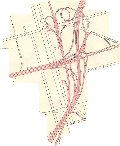
As part of the planning for an east–west route through Baltimore, the alignment of the JFX underwent various modifications. Under the original plan for freeways in Baltimore, the 1962 Baltimore 10-D Interstate System, the JFX would have junctioned I-70N (which became I-70 in 1975) and I-95, which were planned to follow an east–west route through the southern edge of the CBD, near the southeastern edge of the CBD. The JFX would end at roughly the same location where it currently does.[17] As a result of community opposition to other portions of the 10-D System, the 1969 Baltimore 3-A Interstate and Boulevard System was adopted by the city. In this plan, the JFX would continue south along its present alignment then turn east and pass through the Fell's Point neighborhood on a six-lane elevated viaduct, before continuing east along Boston Street to junction I-95 (which was also rerouted to its current alignment) north of the Fort McHenry Tunnel. In the mid-1970s, this plan was modified due to fears that the viaduct would result in destruction of the Fell's Point area, which contains many historic properties. Under the modification, I-83 would continue south and descend into a six-lane underwater tunnel beneath the Inner Harbor, then turn east under the harbor, pass to the south of Fell's Point, return to the surface in the Canton area and continue to I-95.[18]
Under this plan, I-83 was expected to act mostly as a northerly spur to and from the CBD and as an easterly spur to and from the CBD; through traffic was expected to be a small proportion of the total amount making use of the route. I-83's terminus at I-95 would have been a full three-way freeway-to-freeway interchange, with a full complement of ramps provided for access to and from
Truncation

By 1963, the JFX was completed as far south as Guilford Avenue and, by the mid-1970s, was extended to Monument Street. By 1983, the route extended all the way to Pleasant Street, with a dead-end bridge stub indicating plans to continue south along the 3-A alignment to I-95.
In September 1982, however, the segment of the JFX between Pleasant Street and I-95, a distance of 4.4 miles (7.1 km), was officially withdrawn from the Interstate Highway System. Robert Douglas, then the chief of the Interstate Division for Baltimore City (IDBC), stated at the time that the very high financial costs of the I-83 extension (estimated at $609 million in the early 1980s [equivalent to $2.06 billion in 2023[20]], and likely to reach $1 billion [equivalent to $3.39 billion in 2023[20]] with inflation taken into account) led to the cancelation of the segment. As a result, the JFX was truncated at Fayette Street, ending at an at-grade intersection.[21]
To make up for the loss of the I-83 segment, the Jones Falls Boulevard project substantially rebuilt approximately 0.5 miles (0.80 km) of President Street between I-83 and the downtown area to provide the capacity to absorb traffic to and from the Interstate; the project was completed by 1987. Other roadways in the canceled I-83 corridor also benefited from major reconstruction and rehabilitation.
Future
_between_Exit_40A_and_Exit_40B_in_Lower_Allen_Township,_Cumberland_County,_Pennsylvania.jpg)
As Congress worked toward reauthorization of the Surface Transportation and Uniform Relocation Assistance Act, the Greater Lynchburg Chamber of Commerce and other groups in Virginia wanted I-83 extended southward to provide bypasses for Charlottesville, Lynchburg, and Danville, and to link those cities to Greensboro, North Carolina. By June 1991, Robert LaLone, director of programs for the Lynchburg Chamber, admitted that an Interstate was unlikely, but upgrading US 29, with bypasses included, is more likely.[22]
The possibility of extending I-83 (rather than
In 2005,
Exit list
Exit numbers in Pennsylvania were changed in April 2001 from being
| State | County | Location | mi[27][28][29] | km | Old exit[30] | New exit[30] | Destinations | Notes |
|---|---|---|---|---|---|---|---|---|
Shot Tower–Market Place station | ||||||||
| 1 | Fayette Street west | Southbound exit only | ||||||
| Gay Street | Northbound entrance only | |||||||
| 0.30 | 0.48 | — | Pleasant Street | Southbound exit only | ||||
| 0.90 | 1.45 | 3 | Chase Street | Northbound exit only | ||||
| Guilford Avenue | Southbound exit and northbound entrance (from Fallsway) | |||||||
| 1.29 | 2.08 | 4 | Penn Station | |||||
| 1.51 | 2.43 | 5 | Maryland Avenue | Southbound exit and northbound entrance (from Charles Street) | ||||
| 1.85 | 2.98 | 6 | North Avenue Light Rail station and MICA | |||||
| 2.42 | 3.89 | 7 | 28th Street / Druid Park Lake Drive | Split into exits 7A (Druid Park Lake Drive) and 7B (28th Street) northbound | ||||
| 3.02 | 4.86 | 8 | Northbound exit and southbound entrance | |||||
| 4.74 | 7.63 | 9 | Cold Spring Lane Light Rail station and Loyola University Maryland | |||||
| 5.86 | 9.43 | 10 | Northern Parkway | Split into exits 10A (east) and 10B (west) northbound; access to Pimlico Race Course and Sinai Hospital | ||||
MD 133 (Old Court Road) | Northbound exit and southbound entrance | |||||||
| Brooklandville | 9.74 | 15.68 | 23B | No northbound entrance; no exit number northbound; exit number follows I-695; connector north to MD 25 is unsigned MD 25A | ||||
| — | I-695 exit 23A-B; south end of concurrency with I-695; Washington signed southbound | |||||||
MD 139 (Charles Street); New York signed northbound | ||||||||
| Timonium | 12.59 | 20.26 | 16 | Timonium Road | Split into exits 16A (east) and 16B (west) northbound; access to Fairgrounds station | |||
| 14.02 | 22.56 | 17 | Padonia Road | |||||
Warren Road Light Rail station | ||||||||
| 17.18 | 27.65 | 20 | Shawan Road – Cockeysville | Split into exits 20A (east) and 20B (west); access to Oregon Ridge Park and Hunt Valley station | ||||
| Sparks | 20.97 | 33.75 | 24 | Belfast Road – Butler, Sparks | ||||
| Hereford | 24.26 | 39.04 | 27 | |||||
| Parkton | 27.61 | 44.43 | 31 | Middletown Road – Parkton | ||||
| 29.63 | 47.68 | 33 | ||||||
Bel Air | ||||||||
| 34.35 | 55.28 | 37 | Freeland Road | Southbound exit and northbound entrance | ||||
| Mason–Dixon line | 34.50 0.000 | 55.52 0.000 | Maryland–Pennsylvania state line | |||||
| Pennsylvania | York | Shrewsbury Township | 3.529 | 5.679 | 1 | 4 | Diverging diamond interchange | |
| Springfield Township | 7.529 | 12.117 | 2 | 8 | ||||
| 10.340 | 16.641 | 3 | 10 | Access via North Street | ||||
Leader Heights | ||||||||
| 14.230 | 22.901 | 5 | 15 | Directional T interchange; access to York College of Pennsylvania | ||||
| 15.497 | 24.940 | 6 | 16 | Split into exits 16A (south) and 16B (north); access to Penn State York | ||||
| 17.600 | 28.324 | 7 | 18 | Split into exits 18A (east) and 18B (west) southbound | ||||
Springettsbury Township | 18.746 | 30.169 | 8 | 19 | Split into exits 19A (east) and 19B (west) southbound | |||
| Manchester Township | 21.071 | 33.910 | 9 | 21 | Split into exits 21A (east) and 21B (west) northbound; no access from southbound I-83 to westbound US 30 or from eastbound US 30 to northbound I-83 | |||
| 21.648 | 34.839 | 10 | 22 | I-83 BL and US 30 signed southbound | ||||
| 23.716 | 38.167 | 11 | 24 | |||||
| 28.152 | 45.306 | 12 | 28 | |||||
Newberry Township | 31.932 | 51.390 | 13 | 32 | Access to Gifford Pinchot State Park and Roundtop Mountain Resort | |||
| 33.374 | 53.710 | 14 | 33 | |||||
| Fairview Township | 33.874 | 54.515 | 14A | 34 | Valley Green | Northbound exit and entrance | ||
| 34.991 | 56.313 | 15 | 35 | Access to Gifford Pinchot State Park and Roundtop Mountain Resort | ||||
| 35.904 | 57.782 | 16 | 36 | |||||
| 37.893 | 60.983 | 17 | 38 | Reesers Summit | Access via Evergreen Road / Pleasant View Road | |||
| 38.775 | 62.402 | 18 | 39A | |||||
| 39.055 | 62.853 | 39B | toll-by-plate | |||||
| 39.246 | 63.160 | 18A | 40A | Limekiln Road | ||||
Lower Allen Township | 40.499 | 65.177 | 19 | 40B | New Cumberland | Access via Carlisle Road | ||
| Lemoyne | 41.193 | 66.294 | 21 | 41B | Lemoyne | Northbound exit and southbound entrance | ||
| 20 | 41A | Trumpet interchange ; I-81 not signed southbound; Gettysburg not signed northbound | ||||||
| 41.438 | 66.688 | 22 | 41B | Lemoyne | Southbound exit and northbound entrance | |||
| Dauphin | Harrisburg | 42.006– 42.636 | 67.602– 68.616 | John Harris Bridge over the Susquehanna River | ||||
| 42.671 | 68.672 | 23 | 43 | 2nd Street – Directional T interchange; access to Harrisburg Transportation Center | ||||
| 43.149 | 69.442 | 24 | 44A | Access to PA 230 via 13th Street and Sycamore Street | ||||
| 43.450 | 69.926 | 25 | 44B | 17th Street | Southbound exit and entrance | |||
| 43.653 | 70.253 | 19th Street | Northbound exit and entrance | |||||
| 44.658– 45.512 | 71.870– 73.244 | 26 | 45 | Paxton Street / Bass Pro Drive | Bass Pro Drive not signed northbound | |||
| I-283 exits 3A-B; Eisenhower Interchange | ||||||||
| 46.852 | 75.401 | 28 | 46B (NB) 47 (SB) | South end of concurrency with US 322; Eisenhower Blvd not signed northbound | ||||
Lower Paxton Township | 47.940 | 77.152 | 29 | 48 | Union Deposit Road | |||
| 49.220 | 79.212 | 30 | 50 | |||||
| 50.688 | 81.574 | 51 | Northern terminus; signed as exits 51A (south) and 51B (north); north end of concurrency with US 322; I-81 exit 70 | |||||
| 1.000 mi = 1.609 km; 1.000 km = 0.621 mi | ||||||||
Auxiliary routes
I-83 has one auxiliary route: I-283, a connector from I-83 south to I-76 (Pennsylvania Turnpike) and PA 283 southeast of Harrisburg.
Business route
Interstate 83 Business | |
|---|---|
| Location | York, Pennsylvania |
| Length | 5.43 mi (8.74 km) |
| Existed | 1961–present |
_at_Rathton_Road_and_Country_Club_Drive_in_York,_York_County,_Pennsylvania.jpg)
Interstate 83 Business (I-83 Bus.) is a short
From its designation in 1961 until the designation of I-376 Bus. in 2009, I-83 Bus. was the only business route of an Interstate Highway in Pennsylvania.
Major intersections
The entire route is in York County.
| Location | mi | km | Destinations | Notes | |
|---|---|---|---|---|---|
York Township | 0.00 | 0.00 | I-83 exit 15; southern terminus; south end of freeway | ||
| York | 1.86 | 2.99 | South George Street | Southbound exit and northbound entrance; north end of freeway | |
| 3.34 | 5.38 | ||||
| 3.44 | 5.54 | ||||
| Manchester Township | 4.87 | 7.84 | South end of concurrency with PA 181 | ||
| 5.43 | 8.74 | I-83 exit 22; northern terminus | |||
1.000 mi = 1.609 km; 1.000 km = 0.621 mi
| |||||
See also
 U.S. Roads portal
 Maryland Roads portal
 Pennsylvania portal
References
- ^ a b Starks, Edward (January 27, 2022). "Table 1: Main Routes of the Dwight D. Eisenhower National System of Interstate and Defense Highways". FHWA Route Log and Finder List. Federal Highway Administration. Archived from the original on September 20, 2023. Retrieved January 14, 2024.
- ^ a b "Interstate 83 First Md. Road In U.S. System". The Cumberland News. Cumberland, MD. July 10, 1959. p. 4.
Interstate 83 is the designation of the first Maryland highway to become an official part of the federal interstate roads system.
- ^ "Archived copy" (PDF). Archived from the original (PDF) on December 20, 2014. Retrieved May 17, 2013.
{{cite web}}: CS1 maint: archived copy as title (link) - ^ Google (March 8, 2011). "Interstate 83 in Pennsylvania" (Map). Google Maps. Google. Retrieved March 8, 2011.
- ^ Kitsko, Jeffrey J. "Veterans of Foreign Wars of the United States Memorial Highway". Pennsylvania Highways. Archived from the original on February 6, 2019. Retrieved January 25, 2019.
- ^ "I-83/PA 581 Interchange Bottleneck Safety Project". i83beltway.com. Archived from the original on July 31, 2012. Retrieved May 26, 2013.
- ^ Smith, Paul (May 2, 2016). "Bridge Construction along Interstate 83 Corridor to cause Delay". WPMT. Archived from the original on December 21, 2016. Retrieved December 17, 2016.
- ^ "I-83 East Shore Section 1". Pennsylvania Department of Transportation. Retrieved March 11, 2024.
- ^ Boeckel, Teresa (June 28, 2021). "New diverging diamond at I-83 Exit 4 has opened, watch for new traffic pattern". York Daily Record. Archived from the original on September 29, 2021. Retrieved September 29, 2021.
- ^ Boeckel, Theresa (August 1, 2016). "I-83/Mt. Rose Ave. project: What you need to know". York Daily Record. Archived from the original on May 7, 2021. Retrieved January 14, 2024.
- ^ Boeckel, Theresa (December 2, 2016). "Dangerous parts of I-83: What's being done?". York Daily Record. Archived from the original on August 8, 2020. Retrieved December 17, 2016.
- ^ Enright, Matt (February 18, 2022). "The Mount Rose Avenue interchange is finally complete, right? Well ..." York Dispatch. Retrieved March 11, 2024.
- ^ "Work to Begin on I-83 Reconstruction Project in Harrisburg Region in Dauphin County" (Press release). Pennsylvania Department of Transportation. October 19, 2023. Retrieved March 11, 2024.
- OCLC 244481759.
- ProQuest 541176557.
- ProQuest 537830627.
- ^ Kozel, Scott M. (October 24, 1998). "Baltimore Early Expressway Planning". Roads to the Future. Archived from the original on January 1, 2011. Retrieved February 13, 2007.
- ^ Kozel, Scott M. (August 14, 1997). "Baltimore City Interstates". Roads to the Future. Archived from the original on March 4, 2016. Retrieved February 13, 2007.
- ^ "Scale diagram of I-83/I-95 interchange in Baltimore City". Archived from the original on June 28, 2011. Retrieved March 8, 2011.
- ^ Gross Domestic Product deflatorfigures follow the MeasuringWorth series.
- ^ a b Kozel, Scott M. (June 13, 2003). "Baltimore Interstate Highway Cancellation Details". Google Groups. Archived from the original on November 10, 2012. Retrieved January 14, 2024.
- OCLC 25383111.
- ^ "CSVT, Construction Updates". www.csvt.com. Archived from the original on January 8, 2019. Retrieved January 12, 2020.
- ^ Dandes, Rick (October 21, 2019). "Central Susquehanna Valley Thruway River Bridge piers complete; work to continue through winter". The Daily Item. Archived from the original on October 22, 2019. Retrieved January 12, 2020.
- ^ Dandes, Rick (July 8, 2022). "CSVT bridge opened to traffic in both directions". The Daily Item. Sunbury, Pennsylvania. Archived from the original on May 19, 2023. Retrieved July 8, 2022.
- OCLC 244481759. Archived from the originalon July 14, 2014. Retrieved June 14, 2014.
- ^ Highway Information Services Division (December 31, 2005). Highway Location Reference. Maryland State Highway Administration. Retrieved September 2, 2013.
- Baltimore City (PDF).[dead link]
- ^ Highway Information Services Division (December 31, 2013). Highway Location Reference. Maryland State Highway Administration. Retrieved September 2, 2013.
- Baltimore County (PDF).
- ^ Bureau of Maintenance and Operations (January 2015). Roadway Management System Straight Line Diagrams (Report) (2015 ed.). Pennsylvania Department of Transportation. Retrieved June 30, 2015.[permanent dead link]
- York County[permanent dead link] (PDF)
- Cumberland County[permanent dead link] (PDF)
- Dauphin County[permanent dead link] (PDF)
- ^ a b "Pennsylvania Exit Numbering" (PDF). Pennsylvania Department of Transportation. Archived (PDF) from the original on December 23, 2015. Retrieved October 2, 2007.
External links
- Interstate Guide - I-83
- I-83 in Maryland at AARoads.com
- I-83 in Pennsylvania at AARoads.com
- I-83 at MDRoads.com
- Pennsylvania Highways: I-83
- Maryland Roads - I-83
- Pennsylvania Roads - I-83
- Steve Anderson's DCroads.net: Baltimore-Harrisburg Expressway (I-83)
- Steve Anderson's DCroads.net: Jones Falls Expressway (I-83)
- Roads to the Future: Baltimore Harbor Interstate Map
- Kelly, Jacques. "JFX is a long stretch of history," The Baltimore Sun, Saturday, February 7, 2009. Archived August 23, 2015, at the Wayback Machine
| Signed | |
|---|---|
| Unsigned | |
| Lists | |
| Other | |
Routes in italics are no longer a part of the system. Major Interstates are highlighted. | |
| National | |
|---|---|
| Geographic | |