
List of Interstate Highways in Colorado
| Interstate Highways of the Colorado State Highway System | |
|---|---|
.svg) .svg)
Standard highway markers used in the state of Colorado for Interstate 70, Interstate 225, and Interstate 76 Business | |
 Interstate Highways highlighted in red | |
| System information | |
| Maintained by CDOT | |
| Length | 956 mi[1] (1,539 km) |
| Formed | October 11, 1964[1] |
| Highway names | |
| Interstates | Interstate X (I-X) |
| Business routes: | Interstate X Business (I-X Bus.) |
| System links | |
| |

The Interstate Highways in Colorado are the segments of the national
Description
The
The Interstate Highway System covers approximately 956 miles (1,539 km) in Colorado which consists of three
are only served by the same primary routes that run through the Denver Metro Area.History

Colorado had already begun planning a modern inter-city route along the Front Range as early as 1944. The first section of freeway was also in 1944 which would later become Interstate 70 that originally terminated near I-25 in Denver before getting extended across the Rocky Mountains along the US 6 and US 40 corridors.[5] The cities of Denver and Pueblo began constructing a multi-lane route that would become Interstate 25. The first segment of freeway was a two mile segment in Denver, which began construction in August 1948 and was completed two years later. Then, the entire segment of the Valley Highway was completed in 1958, later receiving the Interstate 25 designation.[1] Pueblo would complete the section of freeway in 1959.[6] Interstate 76 is the last primary highway that was completed in 1993, then was later extended to Interstate 70 in Arvada which wasn't completed until 2002.[7] It originally started as Interstate 80S which had two segments in Denver and northeastern Colorado. In 1976, AASHTO renumbered the route to I-76 in accordance with its policy against suffixed routes to eliminate confusion with Interstate 80.[8]
Two more auxiliary routes were planned in the Denver Metro Area around the same time as the primary routes. Interstate 270 was the first route proposed near Denver. It originally was proposed by CDOT to be designated as Interstate 425 but it was rejected by AASHTO and was renumbered to I-270 on February 26, 1959, about six years before construction began between I-70 and Vasquez Boulevard. It was later extended to I-76 (I-80S) in 1967 and then to I-25 in 1999 to continue along the
Interstate highways
| Number | Length (mi) | Length (km) | Southern or western terminus | Northern or eastern terminus | Formed | Removed | Notes | |
|---|---|---|---|---|---|---|---|---|
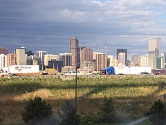
| 298.87[11] | 480.98 | I-25 at the New Mexico state line | I-25 at the Wyoming state line | 1958[6] | current | Runs concurrent with US 87 in its entire length in the state. Nicknamed the Valley Highway through Denver, the Monument Valley Highway in Colorado Springs, and the John F. Kennedy Memorial Highway in Pueblo. It is also part of the unofficial Pan-American Highway[6]
| ||
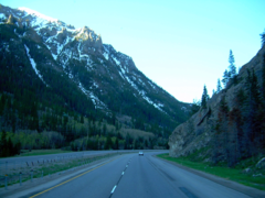
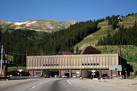
| 449.589[12] | 723.543 | I-70 at the Utah state line | I-70 at the Kansas state line | 1956[1] | current | Longest interstate in Colorado. It was the first interstate highway to be designated in the state of Colorado in 1956. A section from I-270 in Denver to the Kansas State Line is known as the Dwight D. Eisenhower Highway[13] | ||
| 187.29[7] | 301.41 | I-70 in Arvada | I-76 at the Nebraska state line | 1976[7] | current | Originally I-80S until 1976. Last interstate to be completed in the state of Colorado. Completed in 1993.[1] | ||
I-80S
|
178.22[7] | 286.82 | US 87 in North Washington |
I-80S at the Nebraska state line | 1958[8] | 1976 | Two sections of freeway located near Denver and in northeastern Colorado, near the Nebraska border. It was renumbered to I-76 by AASHTO to conform to policy against suffixed routes[8] | |
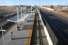
| 11.959[10] | 19.246 | I-25 in Denver | I-70 in Aurora and Denver | 1976[10] | current | Only active Colorado interstate that doesn't run concurrent with another highway in its entire length. It is also the only auxiliary route for I-25 in general. Completed in 1976[10] | ||
| 7.107[14] | 11.438 | I-25/US 36 in unincorporated Adams County | I-70 in Denver | 1965[9] | current | Runs concurrent with US 36 in its entire length. Also known as the Dwight D. Eisenhower Highway[13] | ||
I-425
|
5.35[15] | 8.61 | I-25/US 36 in unincorporated Adams County | I-70 in Denver | 1958 | 1959[15] | Proposed designation for I-270 but was rejected and renumbered by AASHTO in 1959[15] | |
I-470
|
— | — | Beltway around Denver | 1968[16] | — | Proposed, but cancelled due to environmental concerns. Now SH 470 (known locally as C-470), E-470, and Northwest Parkway | ||
| ||||||||
- Interstate Highways
-
 I-25 during rush hour near Downtown Denver
 -
 I-25 betweenDenver
 -
 I-70 crossing the Rocky Mountains
 -
 I-70 at the Eisenhower Tunnel
 -
 I-76 and its western terminus at I-70
 -
 I-76 in northeastern Colorado, near Brush
 -
 I-225 with the Dayton RTD Station in the center near Aurora
 -
 I-270 exit along I-70


Business routes
| Number | Length (mi) | Length (km) | Southern or western terminus | Northern or eastern terminus | Formed | Removed | Notes | |
|---|---|---|---|---|---|---|---|---|
I-25 BL
|
0.5 | 0.80 | I-25/US 85/US 87/US 160 in Trinidad | — | 2009 | Eliminated by a reconstruction project in 2009 which removed the original northern terminus at I-25[17] | ||
I-25 BS
|
1.948[18] | 3.135 | Main Street/S. Fir Street in Aguilar | US 87/US 160 in Aguilar
|
— | — | Inventoried as State Highway 25B[18] | |
I-25 BL
|
4.039[19] | 6.500 | US 87/US 160 in Walsenburg |
I-25/US 85/US 87 in Walsenburg | — | — | Inventoried as State Highway 25C[19] | |
I-25 BL
|
6.75 | 10.86 | US 87 in Colorado Springs |
I-25/US 85/US 87 in Colorado Springs | — | 2007 | Was signed along the CanAm Highway in downtown Colorado Springs. Also ran concurrent with US 85 in its whole length. Decommissioned in December 2007 as part of a highway swap to designate Powers Boulevard as SH 21 | |
I-25 BL
|
1.2 | 1.9 | US 87 in Castle Rock |
I-25/US 85/US 87 in Castle Rock | — | 1996 | Likely unsigned | |
I-70 BL
|
13.265[20] | 21.348 | I-70/US 6/US 50 in Grand Junction | I-70/US 6 in Clifton | — | — | Inventoried as State Highway 70B. Also inventoried as State Highway 70Z along Ute Avenue[20] | |
I-70 BL
|
3.7 | 6.0 | I-70/US 6 in Palisade | I-70/US 6 in Palisade | — | — | ||
I-70 BL
|
4.0 | 6.4 | I-70/US 6 in Rifle | I-70/SH 13 in Rifle | — | 2004 | ||
I-70 BS
|
0.222[21] | 0.357 | I-70 in Silt | US 6 in Silt | — | — | Unsigned. Inventoried as State Highway 70E[21] | |
I-70 BS
|
0.346[22] | 0.557 | I-70 in Eagle | US 6 in Eagle | — | — | Unsigned. Inventoried as State Highway 70F[22] | |
I-70 BS
|
0.577[23] | 0.929 | I-70 in Edwards | US 6 in Edwards | — | — | Unsigned. Inventoried as State Highway 70G[23] | |
I-70 BS
|
0.43 | 0.69 | I-70 in Avon | US 6 in Avon | — | 1999 | ||
I-70 BL
|
2.3 | 3.7 | I-70/US 6 in Frisco | I-70/US 6/SH 9 in Frisco | — | — | ||
I-70 BL
|
2.711[24] | 4.363 | I-70/US 6/US 40 in Idaho Springs | I-70/US 6/US 40 in Idaho Springs | — | — | Signed at both termini. Unsigned along Colorado Boulevard. West end inventoried as State Highway 70K and east end inventoried as State Highway 70R[24] | |
I-70 BL
|
26.80 | 43.13 | I-70/US 40 in West Pleasant View | I-70/US 36/US 40/US 287 in Aurora | — | — | Runs concurrent with Denver, and Aurora
| |
I-70 BS
|
0.400[25] | 0.644 | I-70/US 36/US 40/US 287 in Watkins | SH 36 in Watkins
|
— | — | Only signed along I-70. Was accidentally indicated with multi-colored I-70 shield at exit on westbound I-70.[26] Inventoried as State Highway 70L[25] | |
I-70 BS
|
0.348[27] | 0.560 | I-70/US 36/US 40/US 287 in Strasburg | SH 36 in Strasburg
|
— | — | Unsigned. Inventoried as State Highway 70M[27] | |
I-70 BS
|
0.396[28] | 0.637 | SH 40 in Deer Trail |
I-70/US 40/US 287 in Deer Trail | — | — | Unsigned. Inventoried as State Highway 70N[28] | |
I-70 BS
|
0.353[29] | 0.568 | County Road 153/Main Street in Agate | I-70/US 40/US 287 in Agate | — | — | Unsigned. Inventoried as State Highway 70O[29] | |
I-70 BL
|
2.80 | 4.51 | I-70/US 24/US 40/US 287 in Limon | I-70/US 24/US 40/US 287 in Limon | — | — | Runs concurrent with US 40 and US 287 in its entire length | |
I-70 BS
|
0.528[30] | 0.850 | I-70 in Vona | US 24 in Vona | — | — | Unsigned. Inventoried as State Highway 70P[30] | |
I-70 BL
|
0.377[31] | 0.607 | I-70/US 385 in Burlington | I-70/US 24 in Burlington | — | — | Unsigned along route. Only indicated on I-70. Entirely concurrent with US 385. Inventoried as State Highway 70Q[31] | |
I-76 BS
|
0.472[32] | 0.760 | County Road 398 in Keenesburg | Road 18 in Keenesburg | — | — | Unsigned. Inventoried as State Highway 76B[32] | |
I-76 BL
|
52.31 | 84.18 | I-76/US 34 in Fort Morgan | I-76/US 6 in Sterling | — | — | Longest business route in the Interstate Highway System. Serves Fort Morgan, Brush, Hillrose, Merino, and Atwood | |
| ||||||||
See also
 Colorado portal
 U.S. Roads portal
References
- ^ a b c d e f g "Fun Facts". Colorado Department of Transportation. Retrieved May 3, 2021.
- ^ Colorado Department of Transportation (n.d.). "Segment Descriptions for Highway 070: From RefPoint 0 To RefPoint 500". Colorado Department of Transportation. Archived from the original on May 26, 2012. Retrieved May 2, 2021.
- ^ "CDOT & Transportation Facts". www.codot.gov. Retrieved June 11, 2021.
- ISBN 978-1-4027-3468-7.
- ^ Weingroff, Richard (December 29, 2008). "Why Does I-70 End in Cove Fort, Utah?". Ask the Rambler. Federal Highway Administration. Retrieved June 7, 2009.
- ^ a b c "Interstate 25". Dot.state.co.us. Retrieved June 11, 2021.
- ^ a b c d Colorado Department of Transportation. "The History of I-76 in Colorado". Colorado Department of Transportation. Archived from the original on March 29, 2008. Retrieved June 11, 2021.
- ^ a b c "Interstate 76". 50th Anniversary of the National System of Interstate and Defense Highways. Colorado Department of Transportation. Retrieved June 11, 2021.
- ^ a b "Interstate 270". 50th Anniversary of the National System of Interstate and Defense Highways. Colorado Department of Transportation. Retrieved January 23, 2011.
- ^ a b c d Staff. "Interstate 225". Colorado Department of Transportation. Archived from the original on July 16, 2011. Retrieved June 11, 2021.
- ^ Highway Data Archived July 14, 2011, at the Wayback Machine
- ^ Colorado Department of Transportation (n.d.). "Segment Descriptions for Highway 070: From RefPoint 0 To RefPoint 500". Colorado Department of Transportation. Archived from the original on May 26, 2012. Retrieved June 11, 2021.
- ^ a b "Dwight D. Eisenhower Highway". fhwa.dot.gov. Retrieved June 11, 2021.
- ^ "Segment Descriptions for I-270". Colorado Department of Transportation. Retrieved June 11, 2021.
- ^ a b c Johnson, A. E. (February 26, 1959). "Correspondence with Mr. Mark U. Watrous". American Association of State Highway Officials. Retrieved April 2, 2022 – via AASHTO Route Numbering Archive.
- ^ "Why Doesn't Denver Have a Completed Metropolitan Beltway?". stopjeffersonparkway.com. Retrieved June 11, 2021.
- ^ "Business Route 25". Retrieved May 2, 2021.
- ^ a b Staff, Online Transportation Information System. "Highway 025B between 0 and 1.948". Colorado Department of Transportation. Archived from the original on 2012-09-10. Retrieved June 11, 2021.
- ^ a b Staff, Online Transportation Information System. "Highway 025C between 0 and 4.039". Colorado Department of Transportation. Archived from the original on 2012-09-10. Retrieved June 11, 2021.
- ^ a b "Highway 070B between 0 and 13.265". Colorado Department of Transportation. Retrieved January 15, 2023.
- ^ a b "Highway 070E between 0 and 0.222". Colorado Department of Transportation. Retrieved January 15, 2023.
- ^ a b "Highway 070F between 0 and 0.346". Colorado Department of Transportation. Retrieved January 15, 2023.
- ^ a b "Highway 070G between 0 and 0.577". Colorado Department of Transportation. Retrieved January 15, 2023.
- ^ a b "Highway 070R between 2.188 and 2.711". Colorado Department of Transportation. Retrieved January 15, 2023.
- ^ a b "Highway 070L between 0 and 0.400". Colorado Department of Transportation. Retrieved January 15, 2023.
- ^ "Did CDOT screw up some highway signs in Watkins and Golden?". Denver7 News. Retrieved January 15, 2023.
- ^ a b "Highway 070M between 0 and 0.348". Colorado Department of Transportation. Retrieved January 15, 2023.
- ^ a b "Highway 070N between 0 and 0.396". Colorado Department of Transportation. Retrieved January 15, 2023.
- ^ a b "Highway 070O between 0 and 0.353". Colorado Department of Transportation. Retrieved January 15, 2023.
- ^ a b "Highway 070P between 0 and 0.528". Colorado Department of Transportation. Retrieved January 15, 2023.,
- ^ a b "Highway 070Q between 0.137 and 0.377". Colorado Department of Transportation. Retrieved January 15, 2023.
- ^ a b "Highway 076B between 0 and 0.472". CDOT Online Transportation Information System. Retrieved March 30, 2021.
External links
 Media from Commons
 News from Wikinews
 Quotations from Wikiquote
 Travel information from Wikivoyage