
Lithuania–Poland border
| Lithuania-Poland border | |
|---|---|
 Border sign in Poland | |
| Characteristics | |
| Entities | |
| Length | 104 kilometres (65 mi) |
| History | |
| Established | 1922 1945 |
| Current shape | 6 September 1991 |
| Treaties | Suwałki Agreement (1920) |
The Lithuania–Poland border is the state border between the
It is the only land border that one of the Baltic states (which are members of the EU and NATO) shares with a country that is not a member of the Commonwealth of Independent States.[3]
History
In medieval times, the
In the
In August 1948, the
The border has since remained identical during the Soviet occupation of the Baltic states as well as after the restoration of the independence of Lithuania on 11 March 1990.[11][12][13] On 5 March 1996, both countries signed a treaty on the common border, confirming its status and demarcation, as well as agreeing on the technical cooperation.[14]
Lithuania and Poland joined the Schengen Area in 2007. This meant that all border checkpoints were removed along the border in December 2007, allowing unrestricted border crossing.
On 26 February 2023 Lithuanian customs reinstated third party cargo check points at the Lithuania–Poland border, due increased cargo freight from non-EU countries via Poland and Lithuania to Belarus.[15][16]
Military significance

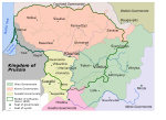
To the
In the event of a Russian attack, the Suwałki Gap would for Russia be important both for connecting Kaliningrad to the rest of Russia, and to prevent military assistance from the other NATO countries to reach the Baltic countries.In July 2016, two years after the
A July 2017 NATO exercise was for the first time focused on defense of the gap from a possible Russian attack,[18] and used troops and materiel from US, British, Polish, Lithuanian and Croatian sources.[19]
In September 2017, Russia and
Former border crossings

In the period 1991–2007, there were three road and one rail border crossing between Poland and Lithuania.[21]
On 1 May 2004, when both Poland and Lithuania joined the European Union, this border became an internal border of the European Union.[22] On 21 December 2007, Poland and Lithuania acceded to the Schengen Agreement.[23] After this, crossing the border became easier, as EU internal borders are open to all traffic with little need for control. There are still, however, occasional customs and police controls against smuggling of restricted goods; these affect only about 1% of travelers.[24][25][26]
Road
Rail
Gallery
-
 Map of Poland from the early 11th century shows Polish and Lithuanian lands separated by Old Prussian and Kievan Rus' territories
 -
 Map of Poland in the first half of the 13th century, shows a border between Duchy of Masovia and Lithuania
 -
 Map of Poland and Lithuania around 1275–1300, with visible Polish–Lithuanian border
 -
 Map of Poland and Lithuania around 1333–1370, with visible Polish–Lithuanian border
 -
 Map of Poland and Lithuania around 1370–1382, with visible Polish–Lithuanian border
 -
 Map of Poland and Lithuania around 1386–1434, with visible Polish–Lithuanian border
 -
 Map of Poland and Lithuania around 1466, with visible Polish–Lithuanian border
 -
 Map of Poland and Lithuania around 1526, with visible Polish–Lithuanian border
 -
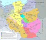
 Map of Polish-Lithuania Commonwealth after its formation in 1569, with visible Polish–Lithuanian border. Ukrainian territories were transferred under the administrative control of theCrown of Poland.
 -
 Map of Lithuania around 1867–1914, with visible Polish–Russian border (Lithuania did not exist at that time)
 -
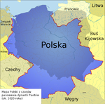
 Selected lines of demarcation between Lithuania and Poland, 1919–1939. Light orange line denotes the line drawn by the Suwałki Agreement.

.png)
.png)


_and_the_Crown_of_the_Kingdom_of_Poland_(red)_in_1386_-_1434.png)


References
- )
- ^ "Prezydent RP - Informacje o Polsce" (in Polish). Archived from the original on 25 June 2009. Retrieved 17 March 2015.. Page gives Polish PWN Encyklopedia as reference.
- ISBN 978-0-7656-1398-1.
- ^ Stephen R. Burant and Voytek Zubek, Eastern Europe's Old Memories and New Realities: Resurrecting the Polish–Lithuanian Union, East European Politics and Societies 1993; 7; 370, online
- ISBN 978-0-313-03456-5.
- ^ Polska w cyfrach[permanent dead link] [in:] E. Romer Atlas Polski współczesnej, 1928[permanent dead link].
- ISBN 0-472-10806-9.
- ISBN 83-05-12769-9.
- ^ Tadeusz Radziwonowicz. "Policja w ochronie granicy na odcinku suwalskim" (PDF) (in Polish).
- ^ a b Marek Kietliński (2002). "Delimitacja polskiej granicy wschodniej 1944-1950" (PDF). Zeszyt Naukowy Muzeum Wojska. Bialystok.
- ISBN 978-0-7425-0178-2.
- ISBN 978-1-139-49617-9.
- ^ "LR AT AKTO Dėl Lietuvos nepriklausomos valstybės atstatymo signatarai". Lietuvos Respublikos Seimas.
- ^ "Lietuvos Respublikos ir Lenkijos Respublikos sutartis dėl bendros valstybės sienos, su ja susijusių teisinių santykių, taip pat dėl bendradarbiavimo ir abipusės pagalbos šioje srityje" [Treaty between the Republic of Lithuania and the Republic of Poland on the common state border, legal relations connected therewith, and on the cooperation and mutual assistance in this field]. Office of the Seimas of the Republic of Lithuania (in Lithuanian). 5 March 1996. Retrieved 9 August 2021.
- ^ Pareigūnai pradeda krovininio transporto kelionės leidimų tikrinimą pasienyje su Lenkija
- ^ Pasienyje su Lenkija patikrinta 110 trečiųjų šalių vilkikų: daliai jų teko grįžti atgal
- ^ Bearak, Max (20 June 2016). "This tiny stretch of countryside is all that separates Baltic states from Russian envelopment". The Washington Post. Retrieved 20 June 2016.
- ^ a b Sytas, Andrius (18 June 2017). "NATO war game defends Baltic weak spot for first time". Reuters. Retrieved 18 June 2017.
- ^ a b "NATO war game defends Baltic weak spot for first time". EURACTIV MEDIA NETWORK BV. 19 June 2017.
- ^ "Closing the Gap: NATO Moves to Protect Weak Link in Defenses Against Russia". WSJ. Dow Jones & Company, Inc. 17 June 2016.
- ^ Kancelaria Sejmu RP. "Internetowy System Aktów Prawnych". sejm.gov.pl.
- ISBN 978-90-04-16223-5.
- ^ "Europe's border-free zone expands". BBC News. 27 December 2007. Retrieved 11 April 2015.
- ^ "Nowe polsko-litewskie drogi po wejściu do Schengen". DELFI. 28 July 2012.
- ^ "Wspólne patrole na polsko-litewskiej granicy :: społeczeństwo". Kresy.pl.
- ^ "Przemyt papierosów przy polsko – litewskiej granicy [ZDJĘCIA]". bialystok. 16 May 2014.
External links
- "Lithuania–Poland cross-border cooperation programme, a EU programme". Archived from the original on 18 July 2008.
- "Suwalki Gap". GlobalSecurity.org.
- "Securing The Suwałki Corridor: Strategy, Statecraft, Deterrence, and Defense". 9 July 2018.
- "This tiny stretch of countryside is all that separates Baltic states from Russian envelopment". The Washington Post.