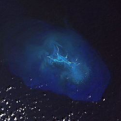
Maro Reef
Appearance

25°24′54″N 170°35′24″W / 25.415°N 170.590°W Maro Reef (
Honolulu, Hawaii, Maro Reef contains about 1 acre (4,000 m2) of dry land which itself can be submerged depending on the tides. Some scientists believe that it "may be on the verge of drowning" because the reefs are detached and are vulnerable to strong storm waves.[1]

USNS Mission San Miguel (T-AO-129)
ran aground on the reef, while running at full speed and in ballast, and sank on October 8, 1957.
The ship was a Buenaventura class tanker built in WW2, and due to problems with LORAN reception (for navigation) miscalculated its location striking Maro reef. It was rediscovered in 2015 by NOAA divers. At 523 feet long it is the largest ship lost on Maro reef and noted for historical significant as WW2 T2 tank vessel.[2]

Dowsett Reef
Dowsett Reef (also called Dowsett's Rock) is to the south of Maro Reef.[3] The sailing ship McNear, a bark, sunk on Dowsett Reef on May 14, 1900.[3] The ship's 33 occupants survived by sailing in boats to Laysan.[3]
See also
- List of reefs
- List of volcanoes in the Hawaiian – Emperor seamount chain
References
- ^ About Maro Reef Archived 2006-02-12 at the Wayback Machine
- ^ "Mystery Solved: The Disappearance of USNS Mission San Miguel". National Marine Sanctuary Foundation. Retrieved 2025-01-17.
- ^ a b c All about Hawaii: The Recognized Book of Authentic Information on Hawaii, Combined with Thrum's Hawaiian Annual and Standard Guide. Honolulu Star-Bulletin. 1913.
- Maro Reef Northwestern Hawaiian Islands Coral Reef Ecosystem Reserve
- Quick Facts on Maro Reef from the PBS Ocean Adventures site
- Papahānaumokuākea Marine National Monument Information Management System

