
Necker Island (Hawaii)
Necker Island Archeological District | |
Kaua'i County, Hawaii | |
| Area | 45.193 acres (182,890 m2) |
|---|---|
| NRHP reference No. | 88000641[1] |
| Added to NRHP | June 13, 1988 |


Necker Island (
The
Administration
Politically, Necker Island is part of the
Geography
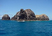
The remnant of a volcanic cone,[6] Necker Island is located about 120 kilometers (65 nmi; 75 mi) southeast of the French Frigate Shoals[7] on the northwestern end of a large, shallow ocean bank.[8] It is a hook-shaped rocky ridge about 1.3 kilometers (0.8 mi) long and between 60 and 200 meters (197 and 656 ft) wide.[9][7] Composed of basalt,[10] the island is steep-sided and barren, with very little soil,[3] and its rocks are heavily scoured and eroded.[11] It is the second-smallest of the Northwestern Hawaiian Islands,[11] with a total area of 45.193 acres (18.289 ha) according to the United States Census Bureau[4] or 41 acres (17 ha)[9] or 39.5 acres (16 ha) according to the United States Fish and Wildlife Service.[11]
The westernmost point on Necker Island is Mo'o Point (or Mo'o Head). The island's "hook" is Northwest Cape, a narrow spur that reaches a maximum height of 48 meters (156 ft) and juts northeastward from the west end of the island for 183 meters (600 ft).[12] Northwest Cape is connected to the rest of the island by a narrow gap that is barely above sea level.[7] Northwest Cape's tip is the northernmost point of the island.[12]
The main ridge of the island and Northwest Cape combine to partially enclose Shark Bay along the northern shore of the island; the bay opens to the northeast and usually is subject to rough seas.[9] Along the island's western shore, West Cove lies between Mo'o Point and the southern end of Northwest Cape.[12] A small islet, 300 feet (91 m) long and rising 10 feet (3 m) above sea level, lies just off Necker Island's eastern tip.[9]
The main ridge of Necker Island has five peaks. East to west, they are:[9]
- Siever's Peak, 61 meters (200 ft) high
- Bowl Hill (or Bryan Peak), 79 meters (259 ft) high
- Summit Hill (or Vaughn Peak), 84 meters (277 ft) high, the island's highest point
- Flagpole Hill, 56.4 meters (185 ft) high
- Annexation Peak (also Annexation Hill or Captain Brown Peak), 75 meters (247 ft) high
Bowl Cave is located on the northern slope of Bowl Hill. It is an important archaeological site.[13]
Necker Island has an average annual rainfall of just under 25 inches (635 mm).[3]
_(20159366959).jpg)
Flora and fauna
Vegetation on Necker Island is limited to low shrubs and grasses, none more than 2 feet (0.6 m) tall.[9] Five species of plants are known to occur:[9]
- Goosefoot shrub (Chenopodium oahuense), found on the island's terraced slopes
- Bunch grass (Panicum torridum) (i.e., kakonakona), which grows on the north slope of the ridge
- Purslane (Portulaca lutea) (i.e., ihi weed), found on flat tops of the ridge
- Pickle weed (wavesbreaking in Shark Bay can reach it
- Ohai shrub (Sesbania tomentasa), which grows on the crest of the ridge
The forester of the Territory of Hawaii attempted to introduce six other species of plants to Necker Island in June 1923, but all had died out by the latter half of the 1930s, if not earlier.[9]
The island is also noted for large numbers of birds.
Although it is the second-smallest of the Northwestern Hawaiian Islands, Necker Island has the second-largest surrounding
Archaeology

Necker Island is known for its numerous religious sites and cultural objects.[10] There are few, if any, signs of long-term habitation, giving rise to the theory that people visited the island for short periods from other islands instead of settling permanently.[11] Many anthropologists believe that the island was a ceremonial and religious site. Necker has 55 currently known sites including 33 ritual sites called heiau, while the remaining sites represent agricultural terraces, miscellaneous platforms, and shelter caves — of which Bowl Cave is the largest.[11] Cultural sites on Necker Island are contemporaneous with those on Nihoa and appear to have been abandoned at roughly the same time several centuries prior to European contact with the Hawaiian Islands.[18][19]
The heiau on Necker Island and Nihoa are unique in the Hawaiian chain representing a raised pavement of basalt stones with upright stones placed across this pavement often near the edges as opposed to the form common to other islands in the chain represented by a high stacked stone wall enclosing a central space.[18] This difference in form represents an earlier iteration of Hawaiian monumental architecture that offers a unique perspective on cultural norms prior to the abandonment of Necker.[19] Thanks to this difference in form, scholars often use the term 'marae' as opposed to 'heiau' in reference to these structures and some scholars argue that the shift in form represents a shift in ritual practice in Hawaii.[20]
Artifacts excavated on Necker Island show a remarkable number of artifacts that would normally be made out of wood rendered in stone. This is especially true of the presence of a series of remarkable carved stone bowls and a bird snare that would have required far more time and effort to create from stone. Additionally, a series of human figures carved from local stone have been recovered from Necker. These statues are up to 1.5 feet (0.5 m) in length and differ in style and medium to similar sculptures (usually rendered in wood) recovered elsewhere in Hawaii.[18] Other artifacts include adzes, fish and squid lures, hammer stones, awls, and other stone tools commonly found across the Hawaiian Islands.[21]
According to the oral traditions of the people of
History
Geological research in the early 21st century indicates that Necker Island is about 10 million years old.[22] While it rises only about 84 meters (277 ft) above sea level now, it reached 1,000 meters (3,281 ft) in height earlier in its history and at one time was comparable in size to modern Oahu.[23][24]
The French explorer
As late as the early 1890s, the Kingdom of Hawaii's claim to Necker Island remained in dispute, and the
In 1902, the
On August 21, 1959, the
In the early 21st century, Necker Island was a place of study for
Access
Access to Necker Island is by boat, and is quite difficult because of the island's nearly vertical coastline.[9] Heavy surf usually precludes landings along the coast in Shark Bay, but a small lee exists west of Northwest Cape, and landing on rocky shelves there is possible in moderately calm weather[9] but can be dangerous in high surf.[7]
Visits to Necker Island are permitted only for scientific, educational, and cultural purposes and require the approval of the United States Fish and Wildlife Service, which gives preference to scientific and cultural visits.[10][11]
Gallery
-
 Ceremony for the annexation of Necker Island (Mokumanamana) by the Provisional Government of Hawaii, May 27, 1894.
 -
 Necker Island
 -
 Moʻo Point (or Moʻo Head), the westernmost point of Necker Island
 -
 Necker Island


See also
- List of volcanoes in the Hawaiian – Emperor seamount chain
- List of islands
- Desert island
- Necker Island (British Virgin Islands) (dab)
- Stonehenge (famous site with standing stones)
References
Footnotes
- ^ "National Register Information System". National Register of Historic Places. National Park Service. January 23, 2007.
- ^ "Mokumanamana | Ocean Futures Society". www.oceanfutures.org. Retrieved October 21, 2021.
- ^ a b c "Necker Island in the Northwestern Hawaiian Islands". www.to-hawaii.com. Retrieved October 21, 2021.
- ^ a b Necker Island: Block 1001, Block Group 1, Census Tract 114.98, Honolulu County, Hawaii, United States Census Bureau.
- ^ a b c d e f g h Bryan, p. 10.
- ^ Harrison, p. 13.
- ^ a b c d e f g h Harrison, p. 14.
- ^ Harrison, pp. 13–14.
- ^ a b c d e f g h i j k l Bryan,p. 8.
- ^ a b c d e f g h i "Papahanaumokuakea Marine National Monument". www.papahanaumokuakea.gov. Retrieved October 21, 2021.
- ^ a b c d e f g h i j k l m n o p q r s t "Mokumanamana (Necker Island) - Hawaiian Islands - U.S. Fish and Wildlife Service". www.fws.gov. Retrieved October 21, 2021.
- ^ a b c Rauzon, p. 27.
- ^ Rauzon, p. 32.
- ^ a b Rauzon, p. 29.
- ^ a b Rauzon, p. 28.
- ^ JSTOR 4069859.
- S2CID 201316222.
- ^ OCLC 50920432.
- ^ OCLC 11841243.
- ^ a b "French Frigate Shoals". Archived from the original on February 13, 2007. Retrieved December 1, 2012.
- ^ "Archeology of the "Mystery Islands" Nihoa and Mokumanamana (U.S. National Park Service)". www.nps.gov. Retrieved March 8, 2022.
- ^ Evolution in Hawaii: A Supplement to Teaching about Evolution and the Nature of Science. Olson S. Washington (DC); 2004.
- ^ https://www.ncbi.nlm.nih.gov/books/NBK208869 National Academy of Sciences. (2004). Evolution in Hawaii: A Supplement to Teaching About Evolution and the Nature of Science, by Steve Olson. Washington, DC: The National Academies Press, 2004.
- ^ a b c d e f g Taillemite.
- ^ a b c d e f Bryan, p. 9.
- ^ Novaresio, 1996. p. 181 "Lapérouse ships, Astrolabe and Boussole"
- ^ Representatives, New Zealand Parliament House of (1900). Journal. Appendix.
- ^ Bryan, pp. 9–10.
- ^ Spatial and Temporal Comparisons of Benthic Composition at Necker Island, Northwestern Hawaiian Islands 2011
Bibliography
- Bryan, Edwin H.,Jr. The Northwestern Hawaiian Islands: An Annotated Bibliography. Honolulu: United States Fish and Wildlife Service, April 1978.
- Étienne Taillemite, “GALAUP, JEAN-FRANÇOIS DE, Comte de LAPÉROUSE,” in Dictionary of Canadian Biography, vol. 4, University of Toronto/Université Laval, 2003–, accessed October 14, 2021.
- Gilmore, Roland. "Mystery Islands." Hana Hou! The Magazine of Hawaiian Airlines. August–September 2010.
- Harrison, Craig S., Seabirds of Hawaii: Natural History and Conservation, Ithaca, New York: Cornell University Press, 1990 ISBN 978-0-801-49722-3
- Rauzon, Mark J. Isles of Refuge: Wlldlife and History of the Northwestern Hawaiian Islands. Honolulu: University of Hawaii Press.
Further reading
- Evenhuis, Neal L.; Eldredge, Lucius G., eds. (2004). Natural History of Nihoa and Necker Islands. Bishop Museum Bulletin in Cultural and Environmental Studies; No. 1. Honolulu, Hawaii: ISBN 1-58178-029-X.
- "Necker Island". The Columbia Gazetteer of North America. Columbia University Press. 2000. Archived from the original on March 29, 2002.
External links
- Northwest Hawaiian Islands Multi-Agency Education Project "Necker Island"
- Janeresture.com: Necker Island
- PBS Ocean Adventures website: Quick Facts on Necker Island
- NOAA Essay
- Papahānaumokuākea Marine National Monument Information Management System
- Pictures of Necker Island (National Oceanic Atmospheric Administration)
- Mokumanamana To Be Visited During Makali'i Voyage (June 14, 2019) on YouTube
- Voyaging Canoes Expect to Reach Mokumanamana this Evening (video)


| International | |
|---|---|
| National | |