
Pest County
Pest County
Pest vármegye | ||
|---|---|---|
.jpg)  .jpg) Clockwise, from top: the Börzsöny Mountain in Nagybörzsöny village, landscape of Kemence, and landscape of Vác | ||
|
Region Central Hungary | | |
| County seat | Budapest | |
| Districts | 18 districts | |
| Government | ||
| • President of the General Assembly | István Szabó (Fidesz-KDNP) | |
| Area | ||
| • Total | 6,393.14 km2 (2,468.41 sq mi) | |
| • Rank | 3rd in Hungary | |
| Population (2023) | ||
| • Total | 1,339,000 | |
| • Rank | 1st in Hungary | |
| • Density | 191.8/km2 (497/sq mi) | |
| GDP | ||
| • Total | HUF 3,607 billion €11.586 billion (2016) | |
| Postal code | 20xx – 23xx, 2440, 2461, 260x – 263x, 2680 – 2683, 27xx | |
| Area code(s) | (+36) 23, 24, 26, 27, 28, 29, 53 | |
| ISO 3166 code | HU-PE | |
| Website | www | |
Pest (
History
The present county Pest was formed after
This section needs expansion. You can help by adding to it. (June 2008) |
Demographics
Religion in Pest County (2011 census)
In 2015, it had a population of 1,226,115 and the population density was 192/km2.
| Year | County population[2] | Change |
|---|---|---|
| 1949 | 686,953 | n/a |
| 1960 | 13.76% | |
| 1970 | 12.43% | |
| 1980 | 10.83% | |
| 1990 | -2.46% | |
| 2001 | 14.11% | |
| 2011 | 12.37% | |
| 2015 | 0.71% | |
| 2018 | 2.91% |
Ethnicity
Besides the Hungarian majority, the main minorities are the Germans (approx. 25,000), Roma (20,000), Slovaks (6,000), Romanians (4,000) and Serbs (1,500).
Total population (2011 census): 1,217,476
Ethnic groups (2011 census):[3]
Identified themselves: 1,090,882 persons:
- Hungarians: 1,024,768 (93.94%)
- Germans: 24,994 (2.29%)
- Romani: 20,065 (1.84%)
- Others and indefinable: 21,055 (1.93%)
Approx. 178,000 persons in Pest County did not declare their ethnic group at the 2011 census.
Religion
Religious adherence in the county according to 2011 census:[4]
- Catholic – 445,106 (Roman Catholic – 435,717; Greek Catholic– 9,235);
- Reformed – 134,848;
- Evangelical – 32,564;
- Orthodox – 1,796;
- Judaism – 947;
- Other religions – 26,485;
- Non-religious – 200,430;
- Atheism – 19,869;
- Undeclared – 355,431.
Economy
The Gross domestic product (GDP) of the county was 13.8 billion euros in 2018, accounting for 10.3% of Hungary's economic output. GDP per capita adjusted for purchasing power was 17,000 euros or 56% of the EU27 average in the same year. The GDP per employee was 69% of the EU average.[5]
Regional structure

| № | English and Hungarian names |
Area (km2) |
Population (2011) |
Density (pop./km2) |
Seat | № of municipalities |
| 1 | Aszód District Aszódi járás |
298.37 | 37,472 | 126 | Aszód | 11 |
| 2 | Budakeszi District Budakeszi járás |
288.95 | 83,670 | 290 | Budakeszi | 12 |
| 3 | Cegléd District Ceglédi járás |
886.30 | 88,952 | 100 | Cegléd | 12 |
| 4 | Dabas District Dabasi járás |
614.23 | 48,289 | 79 | Dabas | 11 |
| 5 | Dunakeszi District Dunakeszi járás |
103.08 | 78,634 | 763 | Dunakeszi | 4 |
| 6 | Érd District Érdi járás |
184.29 | 116,510 | 632 | Érd | 7 |
| 7 | Gödöllő District Gödöllői járás |
449.66 | 139,826 | 311 | Gödöllő | 15 |
| 8 | Gyál District Gyáli járás |
170.99 | 40,853 | 239 | Gyál | 4 |
| 9 | Monor District Monori járás |
329.81 | 64,016 | 194 | Monor | 12 |
| 10 | Nagykáta District Nagykátai járás |
710.12 | 73,959 | 104 | Nagykáta | 15 |
| 11 | Nagykőrös District Nagykőrösi járás |
349.25 | 27,977 | 80 | Nagykőrös | 3 |
| 12 | Pilisvörösvár District Pilisvörösvári járás |
130.81 | 53,201 | 407 | Pilisvörösvár | 9 |
| 13 | Ráckeve District Ráckevei járás |
417.05 | 35,732 | 86 | Ráckeve | 11 |
| 14 | Szentendre District Szentendrei járás |
326.58 | 77,802 | 238 | Szentendre | 13 |
| 15 | Szigetszentmiklós District Szigetszentmiklósi járás |
211.28 | 110,448 | 523 | Szigetszentmiklós | 9 |
| 16 | Szob District Szobi járás |
438.32 | 24,875 | 57 | Szob | 17 |
| 17 | Vác District Váci járás |
362.19 | 68,234 | 188 | Vác | 18 |
| 18 | Vecsés District Vecsési járás |
119.74 | 47,026 | 393 | Vecsés | 4 |
| Pest County | 6,393.14 | 1,217,476 | 192 | Budapest | 187 | |
|---|---|---|---|---|---|---|
Politics
The Pest County Council, elected at the 2019 local government elections, is made up of 44 counselors,[6] with the following party composition:
| Party | Seats | Current County Assembly | ||||||||||||||||||||||||
|---|---|---|---|---|---|---|---|---|---|---|---|---|---|---|---|---|---|---|---|---|---|---|---|---|---|---|
| Fidesz-KDNP | 24 | |||||||||||||||||||||||||
| Momentum Movement | 9 | |||||||||||||||||||||||||
| Democratic Coalition | 7 | |||||||||||||||||||||||||
| Jobbik | 4 | |||||||||||||||||||||||||
Presidents of the General Assembly
| List of presidents since 1990[7] | |
|---|---|
| István Szabó (Fidesz-KDNP) | 2014– |
Municipalities
Pest County has 1
- City with county rights
(ordered by population, as of 2011 census)
- Érd (63,631)
- Towns
- Dunakeszi (40,545)
- Cegléd (36,645)
- Szigetszentmiklós (34,708)
- Vác (33,831)
- Gödöllő (32,522)
- Budaörs (26,757)
- Szentendre (25,310)
- Nagykőrös (24,134)
- Gyál (23,338)
- Dunaharaszti (20,473)
- Vecsés (20,088)
- Fót (19,068)
- Százhalombatta (17,952)
- Monor (17,626)
- Göd (17,476)
- Szigethalom (16,886)
- Pomáz (16,622)
- Dabas (16,386)
- Gyömrő (16,250)
- Veresegyház (15,998)
- Pécel (15,168)
- Abony (14,916)
- Pilisvörösvár (13,667)
- Budakeszi (13,502)
- Törökbálint (12,841)
- Biatorbágy (12,484)
- Nagykáta (12,467)
- Albertirsa (12,016)
- Kistarcsa (11,953)
- Maglód (11,738)
- Pilis (11,568)
- Üllő (11,425)
- Isaszeg (11,152)
- Tököl (10,851)
- Budakalász (10,619)
- Kerepes (10,068)
- Ráckeve (9,755)
- Halásztelek (9,200)
- Diósd (9,056)
- Ócsa (8,985)
- Piliscsaba (8,472)
- Sülysáp (8,195)
- Tura (7,774)
- Dunavarsány (7,363)
- Őrbottyán (7,102)
- Aszód (6,258)
- Tápiószele (5,914)
- Zsámbék (5,174)
- Örkény (4,730)
- Nagymaros (4,679)
- Szob (2,794)
- Újhartyán (2,685)
- Visegrád (1,718)
- Villages
- Acsa
- Alsónémedi

- Apaj
- Áporka
- Bag
- Bénye
- Bernecebaráti
- Budajenő
- Bugyi
- Ceglédbercel
- Csemő
- Csévharaszt
- Csobánka
- Csomád
- Csömör
- Csörög
- Csővár
- Dánszentmiklós
- Dány
- Délegyháza
- Domony
- Dömsöd
- Dunabogdány
- Ecser
- Erdőkertes
- Farmos
- Felsőpakony
- Galgagyörk
- Galgahévíz
- Galgamácsa
- Gomba
- Herceghalom
- Hernád
- Hévízgyörk
- Iklad
- Inárcs
- Ipolydamásd
- Ipolytölgyes
- Jászkarajenő
- Kakucs
- Kartal
- Káva
- Kemence
- Kiskunlacháza
- Kismaros
- Kisnémedi
- Kisoroszi
- Kocsér
- Kosd
- Kóka
- Kőröstetétlen
- Kóspallag
- Leányfalu
- Letkés
- Lórév
- Majosháza
- Makád
- Márianosztra
- Mende
- Mikebuda
- Mogyoród
- Monorierdő
- Nagybörzsöny
- Nagykovácsi
- Nagytarcsa
- Nyáregyháza
- Nyársapát
- Pánd
- Páty
- Penc
- Perbál
- Perőcsény
- Péteri
- Pilisborosjenő
- Pilisjászfalu
- Pilisszántó
- Pilisszentiván
- Pilisszentkereszt
- Pilisszentlászló
- Pócsmegyer
- Pusztavacs
- Pusztazámor
- Püspökhatvan
- Püspökszilágy
- Rád
- Remeteszőlős
- Solymár
- Sóskút
- Szada
- Szentlőrinckáta
- Szentmártonkáta
- Szigetbecse
- Szigetcsép
- Szigetmonostor
- Szigetszentmárton
- Szigetújfalu
- Szokolya
- Sződ
- Sződliget
- Tahitótfalu
- Taksony
- Tatárszentgyörgy
- Táborfalva
- Tápióbicske
- Tápiógyörgye
- Tápióság
- Tápiószecső
- Tápiószentmárton
- Tápiószőlős
- Tárnok
- Telki
- Tésa
- Tinnye
- Tóalmás
- Tök
- Törtel
- Újlengyel
- Újszilvás
- Úri
- Üröm
- Valkó
- Vasad
- Vácduka
- Vácegres
- Váchartyán
- Váckisújfalu
- Vácrátót
- Vácszentlászló
- Vámosmikola
- Verőce
- Verseg
- Zebegény
- Zsámbok
![]() municipalities are large villages.
municipalities are large villages.
Gallery
-
 View of Szentendre
 -
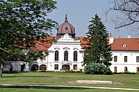 Grassalkovich Palace in Gödöllő
 -
 Citadel of Visegrád
 -
 Cathedral in Vác
 -
 Zsámbék Premontre monastery church
 -
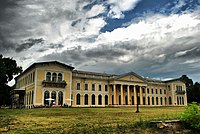 Károlyi Mansion, Fót
 -
 Mailáth Mansion in Törökbálint
 -
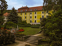
 Choral Castle, Pomáz


_3.jpg)
_2.jpg)
_5.jpg)
.jpg)


International relations
Pest County has a
|
|
References
- ^ Regions and Cities > Regional Statistics > Regional Economy > Regional GDP per Capita, OECD.Stats. Accessed on 16 November 2018.
- ^ népesség.com, "Pest megye népessége 1870-2015"
- ^ 1.1.6. A népesség anyanyelv, nemzetiség és nemek szerint – Frissítve: 2013.04.17.; Hungarian Central Statistical Office (in Hungarian)
- ^ 2011. ÉVI NÉPSZÁMLÁLÁS, 3. Területi adatok, 3.14 Pest megye, (in Hungarian) [1]
- ^ "Regional GDP per capita ranged from 30% to 263% of the EU average in 2018". Eurostat.
- ^ "Megyei közgyűlés tagjai 2019-2024 (Pest megye)". valasztas.hu. Retrieved 2019-10-29.
- ^ Önkormányzati választások eredményei (in Hungarian)
- ^ Külkapcsolatok (Pest megye)
External links
 Definitions from Wiktionary
 Media from Commons
 Travel information from Wikivoyage
 Data from Wikidata
- Official website
 in Hungarian and English


| ||
47°25′N 19°20′E / 47.417°N 19.333°E
| International | |
|---|---|
| National | |
| Geographic | |