
Srijemske Laze
Srijemske Laze
Sremske Laze | |
|---|---|
Vukovar-Syrmia | |
| Municipality | Stari Jankovci |
| Government | |
| • Body | Local Committee |
| Area | |
• Total | 8.8 sq mi (22.9 km2) |
| Elevation | 305 ft (93 m) |
| Population (2021)[3] | |
• Total | 398 |
| • Density | 45/sq mi (17/km2) |
| Demonym(s) | Lazanin (♂) Lazanka (♀) (per UTC+2 (CEST) |
| Area code | +385 032 |
Srijemske Laze (
Name
The name of the village in Croatian or Serbian is plural.
In addition to its official form the name of the village of Srijemske Laze is also known as Sremske Laze in its Ekavian pronunciation of Shtokavian dialect of the pluricentric Serbo-Croatian. Historically, Ekavian pronunciation was common both among autochthonous Serb and Croat communities in Podunavlje while both new post-World War II Serb and Croat settlers predominantly used Ijekavian pronunciation. This however changed in local context after the Croatian War of Independence when Ekavian was associated with Serb and Ijekavian with Croat community with some exceptions.
The word "Srijemske"/"Sremske" is a possessive adjective derived from the Serbo-Croatian word for the Syrmia region itself, meaning that the literal translation of the settlement's name in English is Syrmia's Laze. The name of the village comes from the old Croatian word ''laz'', which means a part of the hillside that can be overcome on foot. [5]
Geography
Southern edge of administrative area of village bordering
History
Middle Ages
In the Middle Ages modern village area were populated by Catholic population.[6] Name of place that than existed was Laz.[6] Origin of old village name comes from Croat word laz, which means the low gentle hill that man can easily exceed walking.[6] Catholic village Laz which was just south of the present day village, was abandoned under the influence of Ottoman Empire in the 17th century.[6]
Resettlement
After the liberation from the
Administrative changes up the collapse of Austro-Hungary
In 1701 village administratively became part of
Kingdom of Yugoslavia
At the end of the
World War II
During World War II village was part of Nazi puppet Independent State of Croatia and Vuka county within it. In 1941 in village lived about 900 inhabitants, out of which during the World War II 300 took part in Yugoslav Partisans and 150 were killed. During the war village was permanent safe place for partisans that because of that call it Little Moscow.[1] At that time in village was created two days of remembrance and celebration of that period. These were Socialist Slava (22 August) and Day of the Dead (14 October).[1] Socialist Slava was created in memory of year 1943, when about 120 people went to partisans, and Day of the Dead commemorate the 56 villagers killed on 14 October 1944 when Ustaše launched a punitive expedition aimed at the destruction of partisan nests.[1]
Era of socialist Yugoslavia
War in Croatia and peaceful reintegration
During the
Demographics
The village is faced with the challenge of
Politics
In Srijemske Laze there are local committees of Independent Democratic Serb Party and New Serbian Party.[6]
Culture
Every year on the Orthodox Christmas Eve (January 6), residents in the churchyard have a bonfire for "Badnjak", the Serbian word for Christmas Eve. In this occasion locals take oak trees from the area and make a ritual fire.
Education
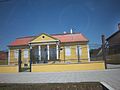
Branch school of Elementary school Stari Jankovci is located in Srijemske Laze. Education at local school is carried out in Serbian.[9]
Gallery
-

-

-
-
 Church of the Nativity of the Virgin, Srijemske Laze
 -


.jpg)
See also
- Church of the Nativity of the Virgin, Srijemske Laze
- Sremske Laze railway station
- Stari Jankovci municipality
References
You can help expand this article with text translated from the corresponding article in Croatian. (October 2012) Click [show] for important translation instructions.
|
You can help expand this article with text translated from the corresponding article in Serbian. (October 2012) Click [show] for important translation instructions.
|
- ^ a b c d Milutin Bekić, Održavanje, uređivanje i korištenje spomenika revolucije u nastavnoj praksi male područne škole. U zborniku: skupina autora, Mala područna škola, Školske novine i Zavod za prosvjetno-pedagošku službu SRH, Zagreb, 1981., str 45. – 48.
- Wikidata Q119585703.
- ^ "Population by Age and Sex, by Settlements" (xlsx). Census of Population, Households and Dwellings in 2021. Zagreb: Croatian Bureau of Statistics. 2022.
- ^ "Dr?avni zavod za statistiku Republike Hrvatske". Archived from the original on 16 November 2011. Retrieved 6 September 2012.
- ^ "Srijemske Laze". o-jankovci.hr. Retrieved 19 February 2023.
- ^ a b c d e f g h i j k l m "Općina Jankovci-Naselja Općine Jankovci:Srijemske Laze". Retrieved 29 June 2013.
- ^ "Srijemske Laze". o-jankovci.hr. Retrieved 19 February 2023.
- ISBN 9532221239.
- ^ Popis osnovnih i srednjih škola s nastavom na jeziku i pismu nacionalnih manjina po modelu A, školska godina 2011./2012., Ministarstvo znanosti obrazovanja i sporta
External links
45°14′N 18°56′E / 45.233°N 18.933°E
Stari Jankovci Municipality | ||
|---|---|---|
| Settlements |  | |
| Attractions | ||
| Traffic routes |
| |
| Neighboring towns and municipalities | ||
Villages of Vukovar-Syrmia County | ||
|---|---|---|
| Villages administered as part of cities |  | |
| Villages serving as municipal seat (other villages in municipality) | ||