
Talk:New York City Subway stations/sandbox

The
The present New York City Subway system is composed of three formerly separate systems that merged in 1940: the
The official count of stations is 472; however, this tabulation classifies some transfer stations as two or more stations, which are called "station complexes" within the nomenclature of the New York City Subway. If station complexes are counted as one station each, the number of stations is 423. 32 such station complexes exist. The reason for the higher count generally lies in the history of the New York City Subway: IRT, BMT and IND stations are usually counted separately, particularly if their lines are not parallel and are adjacent to or on another level to each other. Regardless of how stations are counted, the New York City Subway has the largest number of rapid transit stations in the world.
Included in the station counts is one station that is temporarily closed:
The Metropolitan Transportation Authority is currently building three new New York City Subway stations as part of the
Stations that share identical street names are disambiguated by the line name and/or the cross street each is associated with. For example, "
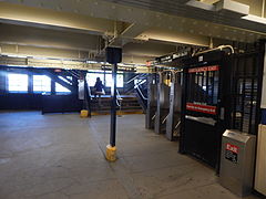
Station facilities and amenities
467 of the 472 stations in the system are served 24 hours a day.[note 1] Underground stations in the New York City Subway are typically accessed by staircases going down from street level. Many of these staircases are painted in a common shade of green, with slight or significant variations in design.[6] Other stations have unique entrances reflective of their location or date of construction. Several station entrance stairs, for example, are integrated into adjacent buildings.[6] Nearly all station entrances feature color-coded globe or square lamps signifying their status as an entrance (see below).[7]
Entrances
Turnstiles and entrance gates
The New York City Subway primarily employs two types of
Lamps
At most of the system's entrances and exits, there is a lamppost or two bearing a colored spherical or cube-shaped lamp. These lights roughly indicate the station's availability (i.e. how often it is accessible): green means a full-time entrance and booth, red means either a part-time booth or no booth, hence either exit-only or entrance with MetroCard. Older lamps are completely colored green or red, while newer ones, called "half-moons", have only the top half colored, while the bottom half is milky white; this is to provide more light, and the half-colored globes have the same meanings as the globes with full colors.[7] There are also some square lamps.
The meaning of the lights is poorly understood by passengers, and was originally more complicated. Green, yellow, and red lights were introduced in the early 1980s to indicate the entrance's availability, mostly to prevent muggings by warning riders away from entrances that were closed at night. Originally, green signified an entrance located at a full-time station booth, which was open
Further, with the introduction of the
Concourse
Many stations in the subway system have
Upon entering a station, passengers may use station booths (formerly known as token booths)
For various reasons, including maintenance costs, decreases in ridership, along with crime and safety issues, many stations have fare control areas, mezzanine areas and entrances that have been closed.[25][26][27] Many mezzanines that previously stretched the entire length of a station have been split or partitioned by fencing or permanent walls. These closed areas have been abandoned or converted into space for Transit Operations or the New York City Police Department.[9][18]
Facilities and amenities
Air conditioning
In August 2006, the MTA announced that all future subway stations, which include
Artwork
Many stations are decorated with intricate ceramic tile work, some of it dating back to 1904 when the subway first opened. The
The


Accessibility
Since the majority of the system was built before 1990, the year the
Entertainment
Since 1987, MTA has sponsored the "Music Under New York" (MUNY) program[38] in which street musicians enter a competitive contest to be assigned to the preferred high traffic locations. Each year, applications are reviewed and approximately 70 eligible performers are selected and contacted to participate in live auditions held for one day.[39][40][41][42]
At present, more than 100 soloists and groups participate in MUNY providing over 150 weekly performances at 25 locations throughout the transit system, for example
The New York City Transit (NYCT) is a subdivision of the Metropolitan Transportation Authority (MTA) that operates the city's subways and buses. The NYCT authorizes these types of free expression in subway stations: "Public speaking; distribution of written materials; solicitation for charitable, religious or political causes; and artist performances, including the acceptance of donations."
Performers must not be within 25 feet (7.6 m) of a token booth or 50 feet (15 m) from an MTA office/tower, blocking access to an escalator, stairwell, or elevator, interfering with transit services or passenger movement; or in an area where construction is occurring. In addition, performance is prohibited during public service announcements and may be no louder than 85 dBA at 5 feet (1.5 m) away or 70 dBa at 2 feet (0.61 m) from a token booth. Performances are prohibited in subway cars.[43]
Restrooms
Restrooms are rare in the subway system as only 129 open restrooms are in 77 of the system's 472 stations.
Newer subway stations have restrooms, including
Retail
Some platforms have newspaper stands that sell various items including newspapers and food. The MTA also installed retail spaces within paid areas in selected stations, including the station concourses of the
According to the MTA, the New York City Subway is home to 345 retail spaces, making over US$70 million in rent and licensing fees in 2009 for the authority. It is continuing to make efforts in attracting more diverse retailers and vendors to set up shop in the subway system.[50][51]
Connections
Rapid transit and rail connections are available at designated stations to
Station platforms and configurations
NYCS station configurations | |||||||||||||||||||||||||||||||||||||||||||||||||
|---|---|---|---|---|---|---|---|---|---|---|---|---|---|---|---|---|---|---|---|---|---|---|---|---|---|---|---|---|---|---|---|---|---|---|---|---|---|---|---|---|---|---|---|---|---|---|---|---|---|
Station with 2 tracks
and 2 side platforms | |||||||||||||||||||||||||||||||||||||||||||||||||
|
| |||||||||||||||||||||||||||||||||||||||||||||||||
Station with 2 tracks
and one island platform | |||||||||||||||||||||||||||||||||||||||||||||||||
|
| |||||||||||||||||||||||||||||||||||||||||||||||||
Local station with 3 tracks
| |||||||||||||||||||||||||||||||||||||||||||||||||
| |||||||||||||||||||||||||||||||||||||||||||||||||
Express station with 3 tracks
| |||||||||||||||||||||||||||||||||||||||||||||||||
| |||||||||||||||||||||||||||||||||||||||||||||||||
Local station with 4 tracks
| |||||||||||||||||||||||||||||||||||||||||||||||||
| |||||||||||||||||||||||||||||||||||||||||||||||||
Express station with 4 tracks
(typical configuration) | |||||||||||||||||||||||||||||||||||||||||||||||||
| |||||||||||||||||||||||||||||||||||||||||||||||||
Express station with 4 tracks
( Atlantic Av–Barclays Ctr ) | |||||||||||||||||||||||||||||||||||||||||||||||||
| |||||||||||||||||||||||||||||||||||||||||||||||||
DeKalb Avenue station(only weekday services shown) | |||||||||||||||||||||||||||||||||||||||||||||||||
|
| |||||||||||||||||||||||||||||||||||||||||||||||||
Out of the system's 472 stations, 280 are underground,
-
 Typical underground station
 -
 Typical elevated station
 -
 Typical entrance to an underground station
 -
 Typical entrance to an elevated station
 -
 Typical underground station mezzanine
 -
 Typical elevated station mezzanine


A typical subway station has waiting platforms ranging from 480 to 600 feet (150 to 180 m) long, though some IND platforms may be as long as 660 to 745 feet (201 to 227 m) long.
Almost everywhere expresses run, they run on the inner one (of 3) or two (of 4) tracks, and locals run on the outer two tracks. In a 3-track configuration, the center track can be used toward the center of the city in the morning and away from the center in the evening, though not every 3-track line has that express service.
There are a number of common platform configurations:
- On a 2-track line, a station may have one center island platform used for trains in both directions, or 2 side platforms, one for a train in each direction.
- For a 3-track or 4-track line, local stops will have side platforms and the middle one or two tracks will not stop at the station.
- For most 3- or 4-track express stops, there will be two island platforms, one for the local and express in one direction, and another for the local and express in the other direction. Each island platform provides a cross-platform interchange between the local and express services.
In a few cases, a 4-track station has an island platform for the center express tracks and two side platforms for the outside local tracks. This occurs only at three stations near major railway stations where the next station along the line is also an express station with the more common platform configuration. The purpose of splitting the platforms is to limit overcrowding by preventing cross-platform interchanges between local and express services. This occurs at
There is one notable 6-track local station,
Stations with two levels
Some stations have two levels. The levels separate the platforms of different services and/or directions. For example:
- the local trains on one level and the express trains on another level
- trains of two different lines on two different levels
- trains of two different directions on two different levels, with a cross-platform interchange on each level
- trains of different services on two different levels that are on the same line
Two lines on different levels
( 145th Street ; onlyrush hour services shown) | |||||||||||||||||||||||||||||||||||||||||||||||||
|---|---|---|---|---|---|---|---|---|---|---|---|---|---|---|---|---|---|---|---|---|---|---|---|---|---|---|---|---|---|---|---|---|---|---|---|---|---|---|---|---|---|---|---|---|---|---|---|---|---|
| |||||||||||||||||||||||||||||||||||||||||||||||||
Different services
on different levels ( 50th Street ) | |||||||||||||||||||||||||||||||||||||||||||||||||
|---|---|---|---|---|---|---|---|---|---|---|---|---|---|---|---|---|---|---|---|---|---|---|---|---|---|---|---|---|---|---|---|---|---|---|---|---|---|---|---|---|---|---|---|---|---|---|---|---|---|
| |||||||||||||||||||||||||||||||||||||||||||||||||
Express and local
trains on different levels ( 86th Street ) | |||||||||||||||||||||||||||||||||||||||||||||||||
|---|---|---|---|---|---|---|---|---|---|---|---|---|---|---|---|---|---|---|---|---|---|---|---|---|---|---|---|---|---|---|---|---|---|---|---|---|---|---|---|---|---|---|---|---|---|---|---|---|---|
| |||||||||||||||||||||||||||||||||||||||||||||||||
Different directions
on different levels ( 125th Street ) | |||||||||||||||||||||||||||||||||||||||||||||||||
|---|---|---|---|---|---|---|---|---|---|---|---|---|---|---|---|---|---|---|---|---|---|---|---|---|---|---|---|---|---|---|---|---|---|---|---|---|---|---|---|---|---|---|---|---|---|---|---|---|---|
| |||||||||||||||||||||||||||||||||||||||||||||||||
Complete lists of stations
The complete list of stations is split by
| Borough | Number of stations | Number of stations | Station complexes | Services |
|---|---|---|---|---|
| The Bronx | 70 | 68 | 2 | |
| Brooklyn | 170 | 157 | 10 | 2 3 4 5 A B C D |
| Manhattan | 148 | 119 | 18 | <6> 7 |
| Queens | 81 | 78 | 2 | J |
| All | 472 | 423 | 32 | <6> 7 |
Station complexes
The New York City Subway has several types of
| Name of station complex | Daytime Services | Borough |
|---|---|---|
14th Street/Sixth Avenue
|
| Manhattan |
14th Street–Eighth Avenue
|
A C E L | Manhattan |
14th Street–Union Square
|
Manhattan | |
34th Street–Herald Square
|
Manhattan | |
42nd Street–Bryant Park/Fifth Avenue
|
<F> M
|
Manhattan |
59th Street–Columbus Circle
|
1 A B C D | Manhattan |
149th Street–Grand Concourse
|
2 4 5 | the Bronx |
161st Street–Yankee Stadium
|
4 B D | the Bronx |
168th Street
|
1 A C | Manhattan |
Atlantic Avenue–Barclays Center
|
2 3 4 5 B D N Q R W | Brooklyn |
Bleecker Street/Broadway–Lafayette Street
|
<F> M
|
Manhattan |
Broadway Junction
|
Z
|
Brooklyn |
Brooklyn Bridge–City Hall/Chambers Street
|
Z
|
Manhattan |
Canal Street
|
Z
|
Manhattan |
Chambers Street–World Trade Center/Park Place
|
2 3 A C E | Manhattan |
Court Square
|
| Queens |
Court Street–Borough Hall
|
2 3 4 5 R W | Brooklyn |
Delancey Street–Essex Street
|
Z
|
Manhattan |
Fourth Avenue/Ninth Street
|
F G N R W | Brooklyn |
Franklin Avenue–Botanic Garden
|
2 3 4 5 S | Brooklyn |
Franklin Avenue–Fulton Street
|
C S | Brooklyn |
Fulton Street
|
Z
|
Manhattan |
Grand Central–42nd Street
|
<7> S
|
Manhattan |
Jay Street–MetroTech
|
Brooklyn | |
Lexington Avenue/51st–53rd Streets
|
Manhattan | |
Lexington Avenue/59th Street
|
Manhattan | |
Lorimer Street/Metropolitan Avenue
|
G L | Brooklyn |
Myrtle–Wyckoff Avenues
|
L M | Brooklyn |
New Utrecht Avenue/62nd Street
|
D N W | Brooklyn |
Roosevelt Avenue/74th Street
|
Queens | |
South Ferry–Whitehall Street
|
1 R W | Manhattan |
Times Square–42nd Street/42nd Street–Port Authority Bus Terminal
|
Manhattan |
Stations with the same name
There are many stations that share the same name. These stations are
| Name of station | Lines | Boroughs |
|---|---|---|
| Third Avenue | • IRT Pelham Line
• IRT White Plains Road Line
|
the Bronx |
| • BMT Canarsie Line
|
Manhattan | |
| Fifth Avenue | • BMT Broadway Line
• IRT Flushing Line
|
Manhattan |
| Seventh Avenue | • IND Culver Line
• BMT Brighton Line
|
Brooklyn |
| • IND Queens Boulevard Line and IND Sixth Avenue Line
|
Manhattan | |
| Eighth Avenue | • BMT Sea Beach Line
|
Brooklyn |
| • BMT Canarsie Line
|
Manhattan | |
Ninth Avenue
|
• ( BMT Culver Shuttle )
|
Brooklyn |
| 14th Street | • IND Eighth Avenue Line
• ( IRT Lexington Avenue Line )
|
Manhattan |
| 18th Avenue | • IND Culver Line
• BMT West End Line
|
Brooklyn |
| 18th Street | • IRT Seventh Avenue Line
• |
Manhattan |
| 20th Avenue | • BMT Sea Beach Line
• BMT West End Line
|
Brooklyn |
| 21st Street | • IND Crosstown Line
• IND 63rd Street Line
|
Queens |
| 23rd Street | • IND Eighth Avenue Line
• IRT Lexington Avenue Line
|
Manhattan |
| • IND Queens Boulevard Line
|
Queens | |
| 28th Street | • IRT Seventh Avenue Line
• IRT Lexington Avenue Line
|
Manhattan |
| 33rd Street | • IRT Lexington Avenue Line
|
Manhattan |
| • IRT Flushing Line
|
Queens | |
| 34th Street | • IRT Flushing Line
• IND Sixth Avenue Line )
|
Manhattan |
| 36th Street | • BMT Fourth Avenue Line
|
Brooklyn |
| • IND Queens Boulevard Line
|
Queens | |
| 42nd Street | • ( BMT Broadway Line )
• IRT Lexington Avenue Line
|
Manhattan |
| 46th Street | • IND Queens Boulevard Line
• IRT Flushing Line
|
Queens |
| 50th Street | • BMT West End Line
|
Brooklyn |
| • IND Eighth Avenue Line and IND Queens Boulevard Line
• IND Sixth Avenue Line
|
Manhattan | |
| 53rd Street | • BMT Fourth Avenue Line
|
Brooklyn |
| • Fifth Avenue (IND Queens Boulevard Line)
• Lexington Avenue (IND Queens Boulevard Line)
|
Manhattan | |
| 57th Street | • BMT Broadway Line
• IND Sixth Avenue Line
|
Manhattan |
| 59th Street | • BMT Fourth Avenue Line
|
Brooklyn |
| • ( IRT Broadway–Seventh Avenue Line )
• IRT Lexington Avenue Line
|
Manhattan | |
| 72nd Street | • IRT Broadway–Seventh Avenue Line
• IND Second Avenue Line
|
Manhattan |
| 77th Street | • BMT Fourth Avenue Line
|
Brooklyn |
| • IRT Lexington Avenue Line
|
Manhattan | |
| 79th Street | • BMT West End Line
|
Brooklyn |
| • IRT Broadway–Seventh Avenue Line
|
Manhattan | |
| 86th Street | • BMT Fourth Avenue Line
• BMT Sea Beach Line
|
Brooklyn |
| • IRT Broadway–Seventh Avenue Line
• IND Second Avenue Line
|
Manhattan | |
| 96th Street | • IRT Broadway–Seventh Avenue Line
• IND Second Avenue Line
|
Manhattan |
| 103rd Street | • IRT Broadway–Seventh Avenue Line
• IRT Lexington Avenue Line
|
Manhattan |
| • IRT Flushing Line
|
Queens | |
| 104th Street | • BMT Jamaica Line
• IND Fulton Street Line
|
Queens |
110th Street
|
• IRT Broadway–Seventh Avenue Line
• IRT Lexington Avenue Line
|
Manhattan |
| 111th Street | • IRT Flushing Line
• IND Fulton Street Line
|
Queens |
116th Street
|
• IRT Broadway–Seventh Avenue Line
• IRT Lexington Avenue Line
|
Manhattan |
| 125th Street | • IRT Broadway–Seventh Avenue Line
• IRT Lexington Avenue Line
|
Manhattan |
| 135th Street | • IND Eighth Avenue Line
• IRT Lenox Avenue Line
|
Manhattan |
| 138th Street | • IRT Jerome Avenue Line
• IRT Pelham Line
|
the Bronx |
| 145th Street | • IRT Broadway–Seventh Avenue Line
• IRT Lenox Avenue Line
|
Manhattan |
| 149th Street | • ( IRT White Plains Road Line )
• IRT Pelham Line
|
the Bronx |
| 155th Street | • IND Eighth Avenue Line
• IND Concourse Line
|
Manhattan |
161st Street
|
• ( IND Concourse Line )
|
the Bronx |
| 167th Street | • IND Jerome Avenue Line
• IND Concourse Line
|
the Bronx |
168th Street
|
• ( IRT Broadway–Seventh Avenue Line )
|
Manhattan |
| • BMT Jamaica Line |
Queens | |
| 170th Street | • IRT Jerome Avenue Line
• IND Concourse Line
|
the Bronx |
| 174th Street | • IND Concourse Line
• IRT White Plains Road Line
|
the Bronx |
| 175th Street | • IND Concourse Line
|
the Bronx |
| • IND Eighth Avenue Line
|
Manhattan | |
| 181st Street | • IND Eighth Avenue Line
• IRT Broadway–Seventh Avenue Line
|
Manhattan |
| 183rd Street | • IRT Jerome Avenue Line
• IND Concourse Line
|
the Bronx |
| 200th Street | • IRT Jerome Avenue Line
|
the Bronx |
| • IND Eighth Avenue Line
|
Manhattan | |
| 207th Street | • IND Eighth Avenue Line
• IRT Broadway–Seventh Avenue Line
|
Manhattan |
| 225th Street | • IRT White Plains Road Line
|
the Bronx |
| • IRT Broadway–Seventh Avenue Line
|
Manhattan | |
| 238th Street | • IRT White Plains Road Line
• IRT Broadway–Seventh Avenue Line
|
the Bronx |
| Atlantic Avenue | • ( BMT Brighton Line )
• |
Brooklyn |
| Avenue U | • BMT Sea Beach Line
• BMT Brighton Line
|
Brooklyn |
| Bay Parkway | • BMT West End Line
• IND Culver Line
|
Brooklyn |
| Bedford Avenue | • BMT Canarsie Line
• IND Crosstown Line
|
Brooklyn |
| Bedford Park Boulevard | • IRT Jerome Avenue Line
• IND Concourse Line
|
the Bronx |
| Bergen Street | • IND Culver Line
• IRT Eastern Parkway Line
|
Brooklyn |
| Beverley Road | • BMT Brighton Line
• IRT Nostrand Avenue Line
|
Brooklyn |
| Borough Hall | • ( IRT Eastern Parkway Line )
|
Brooklyn |
| Broadway | • IND Crosstown Line
• |
Brooklyn |
| • IND Sixth Avenue Line
|
Manhattan | |
| • BMT Astoria Line
• IRT Flushing Line
|
Queens | |
Broadway Junction
|
• ( IND Fulton Street Line )
|
Brooklyn |
| Canal Street | • IRT Seventh Avenue Line
• BMT Nassau Street Line )
|
Manhattan |
| Chambers Street | • IRT Seventh Avenue Line
• BMT Nassau Street Line
|
Manhattan |
| Cathedral Parkway | • IRT Broadway–Seventh Avenue Line
• IND Eighth Avenue Line
|
Manhattan |
| Church Avenue | • IND Culver Line
• IRT Nostrand Avenue Line
|
Brooklyn |
| City Hall | • BMT Broadway Line
• IRT Lexington Avenue Line loop
|
Manhattan |
| Clinton–Washington Avenues | • IND Crosstown Line
• IND Fulton Street Line
|
Brooklyn |
| Cortlandt Street | • IRT Seventh Avenue Line
• BMT Broadway Line
|
Manhattan |
| Court Street | • BMT Fourth Avenue Line
• |
Brooklyn |
| DeKalb Avenue | • BMT Fourth Avenue Line and BMT Brighton Line
• BMT Canarsie Line
|
Brooklyn |
| Dyckman Street | • IND Eighth Avenue Line
• IRT Broadway–Seventh Avenue Line
|
Manhattan |
East 180th Street
|
• ( IRT Dyre Avenue Line )
|
the Bronx |
| Elmhurst Avenue | • IRT Flushing Line
• IND Queens Boulevard Line
|
Queens |
| Flushing Avenue | • BMT Jamaica Line
• IND Crosstown Line
|
Brooklyn |
| Fordham Road | • IRT Jerome Avenue Line
• IRT Third Avenue Line
|
the Bronx |
| Fort Hamilton Parkway | • IND Culver Line
• |
Brooklyn |
Franklin Avenue
|
• ( BMT Franklin Avenue Shuttle )
• IRT Eastern Parkway Line
|
Brooklyn |
| Fulton Street | • IND Crosstown Line
|
Brooklyn |
| • ( IRT Broadway–Seventh Avenue Line )
|
Manhattan | |
Grand Central
|
• ( IRT Flushing Line )
|
Manhattan |
| Grand Street | • BMT Canarsie Line
|
Brooklyn |
| • IND Sixth Avenue Line
|
Manhattan | |
| Gun Hill Road | • ( IRT Third Avenue Line )
• IRT Dyre Avenue Line
|
the Bronx |
| Halsey Street | • BMT Canarsie Line
• BMT Jamaica Line
|
Brooklyn |
| Hoyt Street | • IRT Eastern Parkway Line
• IND Fulton Street Line and IND Crosstown Line
|
Brooklyn |
| Jackson Heights | • IRT Flushing Line
• IND Queens Boulevard Line
|
Queens |
Jay Street
|
• ( BMT Fourth Avenue Line )
|
Brooklyn |
| JFK Airport | • ( BMT Archer Avenue Line )
• IND Rockaway Line
|
Queens |
| Kings Highway | • BMT Sea Beach Line
• BMT Brighton Line
|
Brooklyn |
| Kingsbridge Road | • IRT Jerome Avenue Line
• IND Concourse Line
|
the Bronx |
| Kingston Avenue | • IND Fulton Street Line
• IRT Eastern Parkway Line
|
Brooklyn |
Lafayette
|
• IND Fulton Street Line
|
Brooklyn |
| • IND Sixth Avenue Line
|
Manhattan | |
| Lexington Avenue | • IND 63rd Street Line and BMT 63rd Street Line
• IND Queens Boulevard Line
|
Manhattan |
| Lorimer Street | • BMT Canarsie Line
• BMT Jamaica Line
|
Brooklyn |
| Metropolitan Avenue | • IND Crosstown Line
|
Brooklyn |
| • BMT Myrtle Avenue Line • |
Queens | |
| Mott Avenue | • IRT White Plains Road Line
|
the Bronx |
| • IND Rockaway Line
|
Queens | |
| Myrtle Avenue | • ( BMT Canarsie Line )
• BMT Fourth Avenue Line
|
Brooklyn |
| New Lots Avenue | • BMT Canarsie Line
• IRT New Lots Line
|
Brooklyn |
| Norwood | • IND Concourse Line
|
the Bronx |
| • BMT Jamaica Line
|
Brooklyn | |
| Nostrand Avenue | • IND Fulton Street Line
• IRT Eastern Parkway Line
|
Brooklyn |
| Park Place | • BMT Franklin Avenue Shuttle
|
Brooklyn |
| • IRT Seventh Avenue Line
|
Manhattan | |
| Parsons Boulevard | • IND Queens Boulevard Line
• IND Archer Avenue Line and BMT Archer Avenue Line
|
Queens |
| Pelham Parkway | • IRT White Plains Road Line
• IRT Dyre Avenue Line
|
the Bronx |
| Penn Station | • IND Eighth Avenue Line
• IRT Broadway–Seventh Avenue Line
|
Manhattan |
| Prospect Avenue | • IRT White Plains Road Line
|
the Bronx |
| • BMT Fourth Avenue Line
|
Brooklyn | |
| Prospect Park | • IND Culver Line
• BMT Brighton Line and BMT Franklin Avenue Shuttle
|
Brooklyn |
| Rector Street | • IRT Broadway–Seventh Avenue Line
• BMT Broadway Line
|
Manhattan |
| Rockaway Avenue | • IND Fulton Street Line
• IRT New Lots Line
|
Brooklyn |
| South Ferry | • ( BMT Broadway Line )
• IRT elevated lines
|
Manhattan |
| Spring Street | • IND Eighth Avenue Line
• IRT Lexington Avenue Line
|
Manhattan |
| Sutphin Boulevard | • IND Queens Boulevard Line
• BMT Jamaica Line
|
Queens |
| Sutter Avenue | • IRT New Lots Line
• BMT Canarsie Line
|
Brooklyn |
Times Square
|
• ( IRT Flushing Line )
|
Manhattan |
| Tremont Avenue | • IND Concourse Line
• |
the Bronx |
Union Square
|
• ( IRT Lexington Avenue Line )
|
Manhattan |
| Utica Avenue | • IND Fulton Street Line
• IRT Eastern Parkway Line
|
Brooklyn |
| Van Siclen Avenue | • BMT Jamaica Line
• IRT New Lots Line
|
Brooklyn |
| Wall Street | • IRT Lexington Avenue Line
• IRT Broadway–Seventh Avenue Line
|
Manhattan |
| Woodhaven Boulevard | • IND Queens Boulevard Line
• BMT Jamaica Line
|
Queens |
- The White Plains Road Line.
- The Seventh Avenue (IND Sixth Avenue Line)in Manhattan.
- The 50th Street (BMT West End Line)in Brooklyn.
- The Court Square–23rd Street (IND Queens Boulevard Line)in Queens.
- The Court Square–23rd Street (IND Queens Boulevard Line)in Queens.
- The 36th Street (IND Queens Boulevard Line)in Queens.
- Dyckman Street and Bedford Park Boulevard were both originally known as 200th Street.
Top stations by ridership
These tables list the top ten New York City Subway stations by annual, average weekday, and average weekend
| Rank | Station | Annual ridership (2015) |
|---|---|---|
| 1 | Times Square–42nd Street/42nd Street–Port Authority Bus Terminal
|
66,359,208 |
| 2 | Grand Central–42nd Street
|
46,737,564 |
| 3 | 34th Street–Herald Square
|
39,541,865 |
| 4 | 14th Street–Union Square
|
35,320,623 |
| 5 | 34th Street–Penn Station (Seventh Avenue) | 28,309,160 |
| 6 | 34th Street–Penn Station (Eighth Avenue) | 26,147,434 |
| 7 | 59th Street–Columbus Circle
|
23,299,666 |
| 8 | Fulton Street
|
21,671,684 |
| 9 | Lexington Avenue/59th Street
|
21,407,792 |
| 10 | 86th Street (Lexington Avenue)
|
20,890,828 |
| Rank | Station | Average weekday ridership (2015) |
|---|---|---|
| 1 | Times Square–42nd Street/42nd Street–Port Authority Bus Terminal
|
206,247 |
| 2 | Grand Central–42nd Street
|
160,294 |
| 3 | 34th Street–Herald Square
|
126,776 |
| 4 | 14th Street–Union Square
|
108,440 |
| 5 | 34th Street–Penn Station (Seventh Avenue) | 92,176 |
| 6 | 34th Street–Penn Station (Eighth Avenue) | 84,778 |
| 7 | Fulton Street
|
74,676 |
| 8 | 59th Street–Columbus Circle
|
73,954 |
| 9 | Lexington Avenue/51st–53rd Streets
|
70,686 |
| 10 | Lexington Avenue/59th Street
|
68,988 |
| Rank | Station | Average weekend ridership (2015) |
|---|---|---|
| 1 | Times Square–42nd Street/42nd Street–Port Authority Bus Terminal
|
253,004 |
| 2 | 14th Street–Union Square
|
143,123 |
| 3 | 34th Street–Herald Square
|
132,961 |
| 4 | Grand Central–42nd Street
|
109,137 |
| 5 | 34th Street–Penn Station (Seventh Avenue) | 88,770 |
| 6 | 34th Street–Penn Station (Eighth Avenue) | 83,698 |
| 7 | 59th Street–Columbus Circle
|
82,220 |
| 8 | 86th Street (Lexington Avenue)
|
76,054 |
| 9 | 74th Street–Broadway/
Jackson Heights–Roosevelt Avenue
|
73,373 |
| 10 | Lexington Avenue/59th Street
|
71,184 |
See also
- New York City Subway stations
- List of New York City Subway stations
- List of New York City Subway transfer stations
- List of New York City Subway terminals
- List of closed New York City Subway stations
- List of Staten Island Railway stations
- Accessibility of the Metropolitan Transportation Authority
Notes
- IRT 42nd Street Shuttleare closed during late nights.
- New York Timesarticle: "Junior Torres, smoking a cigarette yesterday near an entrance to the A line on Eighth Avenue and 15th Street, said confidently that he knew exactly what all the globes meant: green means always open, red means always closed, half-green means open most of the time and half-red means closed most of the time. 'That's what they mean,' Mr. Torres said. "Two transit workers near a 14th Street entrance allowed that they had never known just what the colors meant. And Toribio Nunez, coming out of the entrance, said he had always assumed that they were purely decorative, like lights on a Christmas tree. 'I've never looked at them, to tell you the truth,' he said.
"Linda Vaccari and Laura Cugini, tourists from Bologna, Italy, said they were pretty sure that the colors showed the colors of the train lines below, though this often did not work.[7]"
- South Ferry Broadway–Seventh Avenue Line stationas one station, even though these are two stations by MTA standards.
- Botanic Gardenis in an open cut, though they seem to be underground.
- ^ This counts stations that are partially on overpasses, but are not completely elevated.
References
- ^ The remaining New York City borough, Staten Island, is served by the Staten Island Railway, a rapid transit system also operated by the MTA but not connected physically to the New York City Subway.
- ^ a b "Subway and Bus Ridership Statistics 2015". New York Metropolitan Transportation Authority. Retrieved April 19, 2016.
- ^ "(New York City) Subways (Facts and Figures under title of Annual Subway Ridership)". MTA.info. Retrieved 2016-04-19.
- ^ Prior to the founding of the IRT, the Beach Pneumatic Transit was an 1869 demonstration for an underground transit system in New York City, measuring 312 feet (95 m) in length. The concept, heavily based on pneumatic tubes, was not adopted.
- ^ Martin, Andrew (2004-09-09). "USA: Going underground in New York". The Daily Telegraph. Retrieved 2009-07-04.
- ^ a b "SUBWAY ENTRANCE STYLINGS". Forgotten New York. February 14, 2005. Retrieved 6 December 2015.
- ^ a b c d e Kennedy, Randy (August 13, 2002). "Tunnel Vision; The Light at the Top of the Subway Stairs". The New York Times. Retrieved July 7, 2008.
- ^ Faison, Seth (January 21, 1993). "Automating Transit Fares Runs Afoul". The New York Times. Retrieved 6 December 2015.
- ^ a b c d e f "Reopening Closed Subway Entrances" (PDF). pcac.org. New York City Transit Riders Council. November 2001. Retrieved 6 December 2015.
- ^ a b c "How to Ride the Subway". Retrieved November 17, 2013.
- ^ "NYC Official Accessibility Guide" (PDF). nyc.gov. City of New York. 2008. Retrieved 20 September 2015.
- ^ Zimmer, Amy (June 13, 2002). "Stuck in the System: Disabled rider questions subway access". disablednyc.com. City Hall: Metro New York. Retrieved 20 September 2015.
- ^ Flegenheimer, Matt (December 31, 2014). "Exit Alarms in the Subways Are Silenced by the M.T.A." The New York Times. Retrieved 6 December 2015.
- ^ "SUBWAY ENTRANCE LAMPS | | Forgotten New YorkForgotten New York". Retrieved 2016-02-10.
- ^ "New York City Transit". 1999-02-09. Archived from the original on February 9, 1999. Retrieved 2016-02-14.
{{cite web}}: Unknown parameter|deadurl=ignored (|url-status=suggested) (help) - ^ "STATION HOUSES | | Forgotten New York". forgotten-ny.com. Retrieved 2016-02-24.
- New York Municipal Railway Corporation. 1915. Retrieved 4 March 2016.
- ^ a b "MTA New York City Transit Jay Street / Lawrence Street Stations Contract A-35913 / A-35914 / A-35927 / A-35978" (PDF). Metropolitan Transportation Authority. Retrieved 6 December 2015.
- ^ ISBN 978-1-4303-2550-5. Retrieved 27 February 2016.
- ^ "www.nycsubway.org: IRT West Side Line". www.nycsubway.org. Retrieved 2016-02-24.
- ^ "www.nycsubway.org: BMT Nassau Street-Jamaica Line". www.nycsubway.org. Retrieved 2016-02-25.
- ^ "MTA/New York City Transit - Subway Station Booth". web.mta.info. Retrieved 2016-03-13.
- ^ Grynbaum, Michael M. (October 8, 2009). "M.T.A. Station Agent Cuts Leave Riders Lost". New York Times. Retrieved March 13, 2016.
- ^ "Riding Safely". Metropolitan Transportation Authority. Retrieved 6 December 2015.
- ^ "Review of the A and C Lines" (PDF). Metropolitan Transportation Authority. December 11, 2015. Retrieved 19 January 2016.
- ^ "Closed entrances at over 100 subways stations create bottlenecks". am New York. Retrieved 2016-02-24.
- ^ "Brooklyn subway entrances remain locked despite ridership spike". am New York. Retrieved 2016-02-24.
- ^ Roberts, Sam (September 30, 2013). "No Heel Hazards (or Gusts) as Subway Expands". New York Times. Retrieved May 5, 2014.
- Daily News. New York. Retrieved February 10, 2016.
- ^ Jewler, Sam (August 30, 2009). "Does the New York Subway System Really Need to Be This Hot?". New York Magazine. Retrieved May 23, 2014.
However, New York's system now has a few D.C.-style chiller units — some were installed in Grand Central's 4,5,6 station during the Terminal's recent restoration, and there are four in the brand new South Ferry station.
- ^ "Arts for Transit: The Official Subway and Rail Art Guide". Metropolitan Transportation Authority. www.mta.info. Retrieved July 7, 2008.
- ^ Subway Art Hard To Miss, Easy To Uncover NY1 local news channel. Made November 11, 2010. Retrieved November 12, 2010.
- ^ "Subway Art Guide". nycsubway.org.
- ^ "MTA – Arts for Transit | NYCT Permanent Art". web.mta.info. Retrieved 2016-02-10.
- ^ "MTA Guide to Accessible Transit: MTA Subways and Buses". New York Metropolitan Transportation Authority. Retrieved March 8, 2010.
- ^ "About New York City Transit". MTA.info. Retrieved June 1, 2011.
- ^ a b "MTA Guide to Accessible Transit". MTA.info. Retrieved June 1, 2011.
- ^ MTA's Arts for Transit's Music Under New York (MUNY) Section MTA.info website.
- ^ "2010 Music Under New York Auditions". MTA.info (YouTube). May 27, 2010. Retrieved May 29, 2010.
- ^ "2011 Music Under New York Auditions". MTA.info (YouTube). May 27, 2011. Retrieved May 28, 2011.
- ^ "2012 Music Under New York Auditions". MTA.info (YouTube). May 16, 2012. Retrieved May 16, 2012.
- ISSN 0099-9660. Retrieved 2016-02-10.
- ^ "Rules of Conduct & Fines". mta.info. Metropolitan Transportation Authority. Retrieved February 10, 2016.
- ^ Haddon, Heather; Klopsis, Nicholas (April 11, 2010). "Flush with filth: Many subway station bathrooms dirty, or locked up". Newsday. Retrieved November 24, 2015.
- ^ Chatelain, Phillipe Martin. "Hold It In: Why Are Most Bathrooms in the NYC Subway Locked?". Untapped Cities. Retrieved 24 November 2015.
- ^ "Rapid Transit Challenge-restroom locations". Retrieved April 13, 2007.
- ^ Robbins, Christopher (February 25, 2014). "Map: Where Are The Usable Subway Bathrooms?". Gothamist. Retrieved May 8, 2014.
- ^ "Subway planners present the No. 7 extension, with room for improvement". Capital New York. February 15, 2011. Retrieved May 8, 2014.
- ^ "Second Avenue Subway SDEIS Chapter 13: Infrastructure and Energy" (PDF). mta.info. Metropolitan Transportation Authority. Archived from the original (PDF) on May 8, 2014. Retrieved February 10, 2016.
{{cite web}}: Unknown parameter|deadurl=ignored (|url-status=suggested) (help) - ^ Trendy Shops in the Subway MTA.info website. Made August 26, 2010. Retrieved September 2, 2010.
- ^ Morris, Keiko. "Below the Surface Lies Retail". Wall Street Journal. Retrieved 24 November 2015.
- ^ "Press Release – MTA Headquarters – MTA Board Approved Free Transfer Between Westchester County Bee Lines Bus Service and New York City Transit Subway, Buses and Railway Starting in April". MTA. 2007-02-05. Retrieved 2015-10-21.
- ^ Feinman, Mark S. (2000). "History of the Independent Subway". nycsubway.org. Retrieved February 10, 2016.
- ^ "IND Station Lengths". 2011-08-06. Archived from the original on August 6, 2011. Retrieved 2016-02-14.
{{cite web}}: Unknown parameter|deadurl=ignored (|url-status=suggested) (help)
| Current services |
| ||||||||||||
|---|---|---|---|---|---|---|---|---|---|---|---|---|---|
| Defunct services |
| ||||||||||||
| Stations (List) |
| ||||||||||||
| Divisions | |||||||||||||
| Other lists | |||||||||||||
| History |
| ||||||||||||
| Infrastructure | |||||||||||||
| Arts and culture | |||||||||||||
| Miscellaneous | |||||||||||||
| Other rapid transit in NYC |
| ||||||||||||
Cite error: There are <ref group=lower-alpha> tags or {{efn}} templates on this page, but the references will not show without a {{reflist|group=lower-alpha}} template or {{notelist}} template (see the help page).