
Upper Harz Water Regale
Mines of Rammelsberg, Historic Town of Goslar and Upper Harz Water Management System | |
|---|---|
| Includes | |
| Criteria | Cultural: (i)(ii)(iii)(iv) |
| Reference | 623ter-002 |
| Inscription | 1992 (16th Session) |
| Extensions | 2008, 2010 |
| Area | 1,009.89 ha (2,495.5 acres) |
| Buffer zone | 5,654.69 ha (13,973.0 acres) |
| Coordinates | 51°49′12″N 10°20′24″E / 51.82000°N 10.34000°E |
 Location of Upper Harz Water Regale in Germany  Upper Harz Water Regale (Lower Saxony) | |
The Upper Harz Water Regale (
The Upper Harz Water Regale is one of the largest and most important historic
The water system covers an area of roughly 200 square kilometres (77 sq mi) within the
The Water Regale

In German, the term Oberharzer Wasserwirtschaft ("Upper Harz Water Management") has also been frequently used to refer to these historic facilities. But this is not precise enough, because in the last hundred years an intensive, modern water management system has been put in place in the Upper Harz in the form of a number of new
The Upper Harz mining industry
The Upper Harz was once one of the most important mining regions in Germany.[6] The major products of its mines were silver, copper, lead, iron and, from the 19th century, zinc as well. The main source of income, however, was silver. From the 16th to the middle of the 19th centuries about 40–50% of the entire German silver production originated in the Upper Harz.[7] The taxes raised from this contributed significantly to the revenue of the royal houses in Hanover and Brunswick-Wolfenbüttel and helped to secure their positions of power and influence within the Holy Roman Empire.
Its lucrativeness justified a high commitment in terms of investment and effort. Hereby the Upper Harz mining industry produced a considerable number of innovations and inventions, including such important advances as the
Mining and water
Mining becomes a very energy-intensive activity as soon as excavation extends any significant distance underground. In the Upper Harz, vein mining (Gangerzbergbau) was the main form of extraction, with excavation following the near-vertical lodes straight down into the earth.[8] Only a few metres down the ingress of water increased the difficulty of excavation considerably. Initially it was mopped up using men standing on ladders, the so-called Wasserknechten ("water servants"), with their leather buckets. Later, the introduction of horses and whims (Göpel) enabled larger quantities of water to be lifted. But horses were expensive and had to be changed every few hours.[5] As a result, mines - particularly the richer, deeper ones - started to use hydropower systems, able to work continuously, 24 hours a day. To do this, streams were diverted onto water wheels that drove reciprocating pumps in order to raise water from greater depths and in greater quantities. The principle was to raise water with water.[5]
To operate these water wheels, a continuous and substantial supply of water was needed. Although the Upper Harz, with an annual precipitation of over 1300 millimetres per year, received copious amounts of water, the mines often lay high up in the mountains close to the watersheds where there were only a few streams of any size. In addition the flow of mountain streams in the rocky terrain was very variable. It often only needed a few weeks of low rainfall for the water supply to the mines to be threatened. This led to several mines having to be closed.[9]
In their heyday, the mines of the Upper Harz were among the deepest in the world. For example, as early as 1700, shaft depths of 300 metres were exceeded and, around 1830, a depth of 600 metres was attained; this was now so deep that the mine was actually below sea level - something which was considered significant at that time.[10] Deep shafts, however, demanded correspondingly high levels of energy to lift ore and pit water. This high energy consumption, combined with the heavy demand for water, led to even more strenuous attempts to develop the available water power.
The
Water diversion and storage elements
In all, 143 dammed ponds, 500 kilometres of ditch and 30 kilometres of tunnel were built for the collection, diversion and storage of the surface runoff water in the Upper Harz.[11] In addition about 100 kilometres of drainage adits are included as part of the Regale. These facilities were not, however, all in operation at the same time. The Harzwasserwerke today operates and maintains 65 dammed ponds, 70 kilometres of ditch and 20 kilometres of tunnel.[12] Several smaller dammed ponds still belong to the Lower Saxon State Forestry Department or are even in private hands.
The principle of water diversion is to collect the water in ditches, running almost parallel to the
The technology of the time did not enable dams to be built with heights of more than about 15 metres. This meant that many small ponds had to be laid out rather than a few larger ones. By arranging the ponds in a cascade, water could be retained at a high elevation in order to drive as many water wheels as possible. A number of these pond cascades were built, comprising four to six ponds.
The majority of water wheels were used to drive pumps. Occasionally, the power they generated had to be transmitted over several hundred metres to the mine itself using
-
 Arches on the Zellerfeld Ditch
 -
 Walkers by the Morgenbrodstal Ditch near Dammhaus
 -
 Regulating equipment for water supply on the Dam Ditch
 -
 Reconstruction of a reversible water wheel, with a 9.5 metre diameter, in Clausthal-Zellerfeld


Structures
- Reservoirs
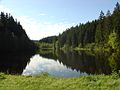
The 143 reservoirs or storage ponds, known as Teiche (singular: Teich), were impounded using
- Ditches
The ditches are supply channels almost parallel to the terrain contours, with a very slight incline of around 1-2 per mille and are accompanied by an inspection path.
- Tunnels
The underground water tunnels of between 20 and 1000 metres long were the most expensive investments in the Upper Harz Water Regale. They were worth the cost however because of their low operating costs and high hydraulic capacity.
- Special structures
- The aqueductbuilt from 1732 to 1734 with a length of over 900 metres and a height of 16 metres.
- The Oderteich differs considerably from the other Upper Harz ponds with regard to its construction materials and dimensions. Following its completion in 1722 to the start of the modern dam building period in 1892, it was the largest dam in Germany.[13]
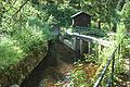
- In the Polsterberg Pumphouse water could be pumped from the Dam Ditch to a height of 8 metres using hydropower.
- The Huttaler Widerwaage is also frequently mentioned in this connexion: it is quite complex and enables water to flow in two different directions.
-
 The Smelter Pond (Hüttenteich) near Altenau
 -
 The dam of the Klein Clausthal Pond
 -
 The Huttaler Widerwaage and portal of the Huttal Tunnel
 -
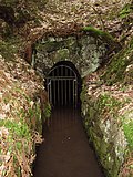 Exit portal of the Lower Hasenbach Tunnel


Tourism
Due to the sheer number of structures and the length of the ditches the Upper Harz Water Regale is best explored on foot. Thanks to the With a few exceptions, most of the ponds can be used by swimmers during the summer months. The majority are also leased to local angling clubs.
History
Construction
Mining activity in the Harz goes back to the 10th and 11th centuries.[6][13] The first water wheels in the Harz were erected in the 13th century in the Pandelbach valley southeast of Seesen.[11] At that time mining, including this early use of the so-called waterworks (Wasserkünste) for the mines, was managed by the Cistercian abbey at Walkenried.
The Black Death in the Middle Ages depopulated the Harz to a great extent and almost brought mining operations to a standstill. Another factor was probably that mining had reached its technical limits at the time with depths of up to about 60 metres.
A clear recovery followed from about 1520 onwards, initially at the instigation of the Duke of Brunswick-Wolfenbüttel,
It was the extensive use of hydropower that made the mining boom in the Upper Harz possible. As the mines became ever deeper over time they needed more and more energy. The lack of water following months of little rain or long periods of frost was time and again a limiting factor for the mines.[8] The expansion of the water system was achieved by raising the existing pond dams, building new dams, laying new ditches and extending existing ditch runs.
Further improvements: water tunnels and drainage adits

One example of the expansion of the Water Regale network was the optimisation of several ditch courses (the Dam Ditch, Upper and Lower Rosenhof Chutes), mainly during the 19th century, by the construction of so-called Wasserläufen (also Wasserüberleitungsstollen) or water tunnels. These enabled the distance travelled by the water to be significantly shortened.
Because most of the energy was needed to drain the mines of water and because the need for that continued to grow as mines became deeper, there were attempts early on, to dewater mines using drainage adits (Wasserlösungsstollen). This entailed driving tunnels from the mines to the valleys, through which water could drain away under gravity. The deeper the level of drainage, the longer the adit had to be. The longest of these tunnels is the Ernst August Adit, built in the mid-19th century, which is 35 kilometres long. It collected water from the mines in Bockswiese, Lautenthal, Zellerfeld, Clausthal and Wildemann and led it to Gittelde on the edge of the Harz.[8]
Heyday and decline
About 80–90% of the ponds in the Upper Harz Water Regale were created in the 16th and 17th centuries,
With the nationalisation of the mines on 1 January 1864 by the
An inventory dating to the year 1868 reveals that a total of 198 water wheels of various diameters and a total capacity of about 3000 horsepower were driven by the Upper Harz Water Regale .[14]
Around 1900, mining shaft depths of 1,000 metres were attained. But the cost of mining at greater and greater depths continued to rise. At the same time the industry had to compete with other metal mining areas at home and abroad in an era of improving transportation.
Hydroelectric power

Following the demise of the mining industry in 1930, water from the Upper Harz Water Regale was switched to generating electricity, some new structures being built as a result. The generation of electricity was carried out by Preussag until 1980 in the Kaiser Wilhelm (maximum output 4.5
The Water Regale today
Following the closure of power stations the facilities of the Water Regale were initially transferred to the Lower Saxony State Forestry Department, which maintained them through the Clausthal-Schulenberg Forestry Office at the cost of much labour and money. In order to relieve the state purse, in 1991 the Harzwasserwerke was given the task of operating and maintaining 65 reservoirs, 70 kilometres of ditch and 20 kilometres of water tunnel. The Harzwasserwerke has delegated the management of the Upper Harz Water Regale to its Clausthal office. No public money is spent; the cost of maintenance, a seven-figure sum annually, has to be borne by the Harzwasserwerke through its sale of drinking water.[12]
In addition to the facilities entrusted to the Harzwasserwerke there is a large number of dam ruins, tunnel entrances and several hundreds of kilometres of ditches that are not maintained. These structures enjoy the status of a so-called passive protected monument. That means that they are like the ruins of castles, subject to very gradual decay, but which may not be destroyed by modern measures without legal permission under conservation law.[13]
The Hirschler Pond is used by the public utilities of Clausthal-Zellerfeld to supply drinking water to Clausthal-Zellerfeld and Altenau; similarly Zellerfeld uses the Upper and Middle Kellerhals Ponds. Hahnenklee gets its drinking water from the Auerhahn Pond, the New Grumbach Pond and the Upper Kellerhals Pond.

Similar systems
There are similar water supply systems in the historic silver mining region near
See also
References
Citations
- ^ Langenscheidt's Muret-Sanders German-English dictionary (Berlin, 2004) gives one translation of the German word Regal as "regale", a legal and historical term.
- ^ ISBN 3-923605-42-0
- ^ Oberharzer Wasserregal zum Weltkulturerbe ernannt tagesschau.de, accessed on 1 August 2010
- ^ "Mines of Rammelsberg, Historic Town of Goslar and Upper Harz Water Management System". UNESCO World Heritage Centre. United Nations Educational, Scientific, and Cultural Organization. Retrieved 25 Jun 2022.
- ^ ISBN 3-00-009609-4
- ^ a b c Fleisch, Gerhard (1983), Die Oberharzer Wasserwirtschaft in Vergangenheit und Gegenwart (in German), Clausthal-Zellerfeld: TU Clausthal
- ^ Bornhardt, Friedrich Wilhelm Conrad Eduard (1900), Blei-, Silber- und Kupfererzeugung im Oberharz und am Rammelsberg (in German), Niedersächsische Bergarchiv Clausthal, IV B 1b 151
- ^ ISBN 3-89720-725-7
- ISBN 3-540-62930-0
- ^ Friedrich Wilhelm Conrad Eduard Bornhardt (1934), Wilhelm August Julius Albert und die Erfindung der Eisendrahtseile (in German), Berlin: VDI-Verlag
- ^ a b c d Teicke, Justus (September 2007), "Talsperren auf dem Weg zum Weltkulturerbe: Das Oberharzer Wasserregal" (PDF; 1,5 MB), Tagungsband zum 14. Deutschen Talsperrensymposium, Berichte des Lehrstuhls und der Versuchsanstalt für Wasserbau und Wasserwirtschaft (in German), München: TU München
- ^ a b c Schmidt, Martin (2005), Das Kulturdenkmal Oberharzer Wasserregal (PDF; 880 kB) (in German), Clausthal-Zellerfeld: Harzwasserwerke
- ^ a b c d e Schmidt, Martin (2007), WasserWanderWege (in German) (3. ed.), Clausthal-Zellerfeld: Pieper
- ISBN 3-9806619-2-X
- ^ "Hydropowerwerke der Harz Energie". Harz Energie. Retrieved 27 March 2009.
- ^ "Geschichte: Nachbergbauzeit von 1910 bis heute". Bergwerksmuseum Grube Samson. Retrieved 27 March 2009.
Sources
- Schmidt, Martin (2005), Das Kulturdenkmal Oberharzer Wasserregal (PDF; 880 kB) (in German), Clausthal-Zellerfeld: Harzwasserwerke
- Schmidt, Martin (2002), Die Wasserwirtschaft des Oberharzer Bergbaus, Schriftenreihe der Frontinus-Gesellschaft e. V. (in German) (3. ed.), Hildesheim: Harzwasserwerke, ISBN 3-00-009609-4
- Schmidt, Martin (2007), WasserWanderWege (in German) (3. ed.), Clausthal-Zellerfeld: Pieper
- Knissel, Walter; Fleisch, Gerhard (2005), Kulturdenkmal "Oberharzer Wasserregal" – eine epochale Leistung (in German) (2. ed.), Clausthal-Zellerfeld: Papierflieger, ISBN 3-89720-725-7
External links
Mines of Rammelsberg, Historic Town of Goslar and Upper Harz Water Management System UNESCO Official Website
NESCO Official WebsiteU
- Upper Harz Water Regale
- Location plan by the Harzwasserwerke for the currently active facilities (PDF; 679 kB)