
Vĩnh Long province
Vĩnh Long province
Tỉnh Vĩnh Long | |
|---|---|
 | |
|
UTC+7 (ICT) | |
| Calling code | 70 |
| ISO 3166 code | VN-49 |
| Website | vinhlong |
Vĩnh Long (Vietnamese:
Administrative history

Modern-day Vĩnh Long was part of Long Hồ dinh (barrack, 營) established by the
The area saw some of the heaviest fighting between the
In 1951, the Southern Resistance Administrative Committee of the
After the
In 1992, Mang Thít District was re-split from Long Hồ District. In 2007, Bình Tân District was created.
Geography
Lying between the Hau and Tien rivers in the center of the Mekong Delta, Vĩnh Long is a province well known for fishing.
Administrative divisions
Vĩnh Long is subdivided into eight district-level sub-divisions:
- 6 districts:
- Bình Tân
- Long Hồ
- Mang Thít
- Tam Bình
- Trà Ôn
- Vũng Liêm
They are further subdivided into five commune-level towns (or townlets), 94 communes, and 10 wards.
Economy
Traveling by water is a common practice here for such mundane tasks as grocery shopping as well as getting to restaurants and tourist attractions located on small islets accessible only by boat. Tourist infrastructure is still in its infancy here, but comfortable lodging and great food can be had for very reasonable prices.
Transportation
Located approximately 135 kilometres (84 mi) southwest of Hồ Chí Minh City, Vĩnh Long is easily accessible by bus, van or car using National Route 1 and the Mỹ Thuận Bridge.
Notable Vĩnh Long residents
- Võ Văn Kiệt
- Petrus Ký
- Ngô Đình Thục
- Hoài Lâm
Gallery
-
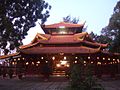 Ngọc Viên Ancestral Temple Vietnamese Mendicant Buddhist Sect
 -
 Statue of Guanyin of the Nine Dragons
 -
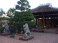 Công Thần Temple
 -
 Vĩnh Long Cathedral
 -
 Văn Thánh Temple


References
- ^ "Tình hình kinh tế, xã hội Vĩnh Long năm 2018". Cổng thông tin điện tử tỉnh Vĩnh Long. Retrieved 10 May 2020.
External links
Places adjacent to Vĩnh Long province | |
|---|---|
| International | |
|---|---|
| National | |
| Geographic | |
| Other | |